Issue Date: Monday, June 20th, 2016
Issue Time: 2:10PM MDT
Valid Period: June 21st through July 5th

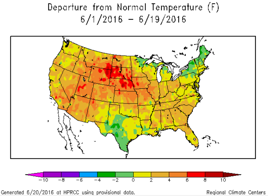
It has been a warm and rather dry start to summer in Colorado. The map below shows the temperature anomaly since June 1st, with 3-8F values common across our state. Regarding precipitation, most of the state is below normal for June, with isolated pockets of plentiful rainfall limited to parts of the Southeast and Northeast Plains. Fortunately, May precipitation was at or above average for many, thus drought concerns have been kept at bay thus far.
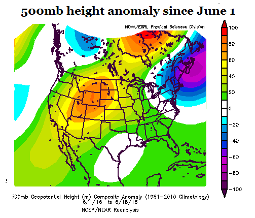
The warm temperatures at the surface have been associated with clockwise circulation anomaly in the upper atmosphere, as shown below. This promotes subsidence above the boundary layer and limits widespread rainfall. Note that it does not preclude rainfall altogether as we saw yesterday (6/19/2016) when over 1 inch of rain fell from a storm that formed almost directly under the heart of the ridge.
 Looking forward, we see a more active weather, and overall cooler (though “cool” in the summer is relative!) pattern for eastern Colorado. Meanwhile, western Colorado will continue to stay warm as the ridge intensity pulses. In the western part of the state, we turn our eyes farther southwest to see when the southwest North American monsoon may start. Climatologically, the last week of June and first week of July typically sees a marked increase in low-level moisture across the southwest. For example, Phoenix’s average dew point temperature goes from about 39F on June 21st to 55F by June 8th. Up until now, moisture has been certainly lacking with central Arizona breaking high-temperature records accompanied by very little humidity. Looking forward, there are some indications that monsoonal moisture may make it northward for the July 4th weekend. However, this is not the “most likely” outcome at this point in time.
Over the next 14 days, we have identified three organized precipitation events that are expected to impact the state. At this time, each event is categorized as “No Apparent Flood Threat”. Below, each event is described in more detail.
Event #1: Friday (6-24-2016) through Saturday (6-25-2016)
No Apparent Flood Threat as fast motion of disturbance will likely limit heavy rainfall
A moderate-sized disturbance, currently off the coast of North America will come ashore and dent the ridge over the Rocky Mountain states. At least one wave of showers and thunderstorms will occur during the Friday – Saturday timeframe. The locations most likely to be impacted are the Front Range mainly north of Colorado Springs and the Northeast Plains. Farther south, rainfall coverage appears to be limited given the position of the ridge. Up to 1.25 inches of rainfall, along with gusty westerly winds, is possible with this event. An elevated threat is not warranted at this time.

Event #2: Tuesday (6-28-2016) through Thursday (6-30-2016)
No Apparent Flood Threat because ridge strength will limit organized heavy rainfall
For several days following Event 1, the ridge is expected to re-exert dominance. Then, current guidance suggests it will weaken on its eastern periphery and allow more of a northerly flow to affect eastern Colorado. Again, this kind of situation is not particularly conducive to widespread heavy rainfall because the strength and duration of moisture return is insufficient. Nonetheless, enough instability should be in place for some moderate rainfall amounts, up to 1.5 inches, in the Front Range, Urban Corridor and Northeast Plains during this period.
Event #3: Monday (7-4-2016) through Tuesday (7-5-2016)
No Apparent Flood Threat but rainfall possible statewide
Another lull is expected after Event #2 where the ridge will strengthen and provide warm and dry weather for Colorado. Thereafter, in time for Independence Day, there are several possible scenarios painted by guidance today. First, the ridge weakens on its eastern periphery, like Event 2, and allows for small disturbances to propagate southward (east of the Continental Divide). Second, there are also indications that the southwest US heat low will finally be strong enough to begin transporting monsoonal moisture northward. Given the spread in guidance, there is no need for an elevated flood threat at this time. Also, given the dichotomous nature of these scenarios (i.e. if the first scenario occurs, western CO stays dry; if the second occurs, eastern CO stays dry), we do not include a precipitation map for this event.