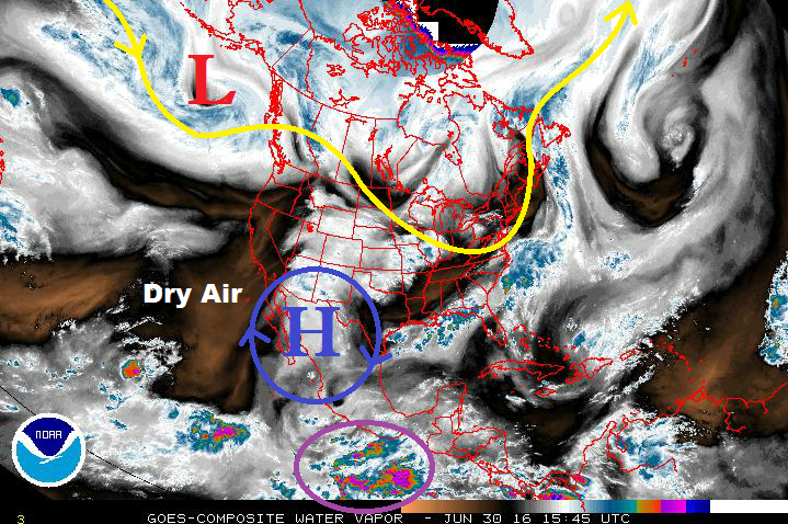
Issue Date: 6/30/2016
Issue Time: 1:10 PM
The upper-level low (denoted by a red “L” in the water vapor image) will shift slowly east through this coming weekend, ejecting weak disturbances into the mid-/upper-level flow. These disturbances will slide across the central/northern Rockies, working with the monsoonal moisture stuck underneath the high pressure ridge (blue “H”). Friday and Saturday (July 1/July 2) will be the wettest days of the first event, with moisture subsiding/shifting east slowly through the weekend.
By Monday (July 4), the moisture will subside and dry westerly flow will be overhead as high pressure builds across the region. This warming and drying period will continue through Thursday (July 7), only being broken up by a few afternoon high country showers/thunderstorms as sunshine and orographic effects work on residual moisture. This dry period will be hot, especially over the lower elevations of eastern Colorado. The Arkansas River Valley could see multiple afternoons with high temperatures over 100 F.
After the warming/drying period, another moisture surge awaits (Event #2) for the end of next week. This surge will be of the Gulf moisture type, transported into the state by south/southeasterly flow across the US plains. Moisture will be confined essentially along/east of the Continental Divide, with the strongest storms over the eastern plains. A cool front will escort this moisture eastward again Sunday/Monday (July 10/July 11), bringing another dry/warming period to Colorado. By the middle-to-end of that week (July 12-15), there are hints of monsoonal moisture returning to the state as the eastern Pacific becomes active with tropical activity. This would mainly impact areas along and west of the Continental Divide. This surge will be discussed as Event #3 below.
Event #1: Friday (07-01-2016) through Sunday (07-03-2016)
Elevated Flood Threat Continues
Event #1 is a continuation of Event #1 as discussed in Monday’s FTO. Multiple disturbances will eject from the upper-level low, currently over the Gulf of Alaska (but shifting eastward), providing upper-level support for scattered-to-widespread showers and thunderstorms through Saturday. Moisture will begin to subside and slide eastward on Sunday as the upper-level ridge builds across the region and dry, westerly flow encroaches on Colorado. Due to these factors, Sunday will see a downtick in thunderstorm intensity/coverage as compared to Friday and Saturday.
Event #2: Friday (07-08-2016) through Sunday (07-10-2016)
No Apparent Flood Threat as Best Moisture Remains Over the Plains
A Gulf moisture surge is forecast to move into eastern Colorado late next week, continuing through the weekend, as south/southwesterly low-level flow asserts itself across the central US. The moisture will be essentially confined along/east of the Continental Divide. The strongest storms will likely remain east of I-25 and over the plains, especially the Northeast Plains. Due to the higher threshold for flash flooding over the plains, no flood threat is apparent. If sufficient moisture can move back into the Front Range/Urban Corridor, a flood threat could emerge. Stay tuned.
Event #3: Tuesday (07-12-2016) through Friday (07-12-2016)
No Apparent Flood Threat due to Uncertainty Surrounding Timing of Monsoon Surge
The strength of the summer ridge, as well as the timing of the tropical activity in the eastern Pacific will play a big role in the eventual emergence of Event #3. At this current time, it looks more probable to occur late in the week, with the best moisture/support for storms over the High Country. Due to the uncertainties surrounding this event, no precipitation map will be issued. Stay tuned for an update on this time period in Monday’s FTO.


