Issue Date: 6/27/2016
Issue Time: 12:12 PM
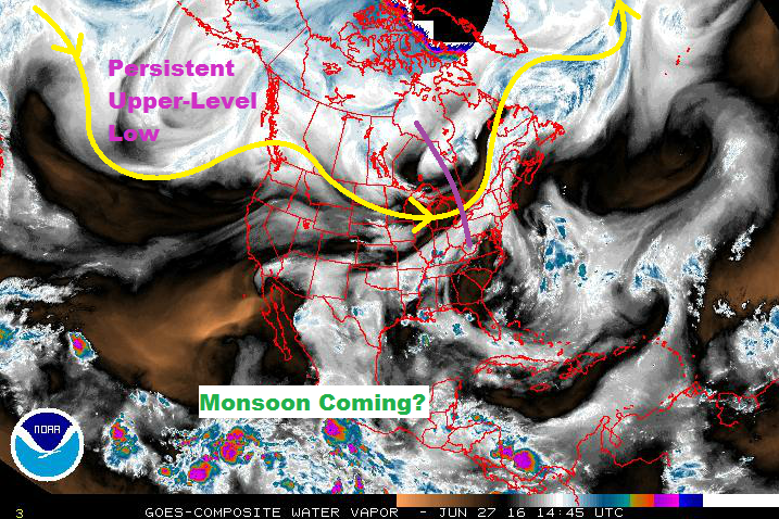
A persistent upper-level low near the Gulf of Alaska will be the main player during this FTO period, accompanied by what appears to be the first real gasp of monsoonal moisture this season. The persistent low will keep the flow above Colorado west/northwesterly, ejecting disturbances across the region. Meanwhile, from the south/southwest, the North American Monsoon is awakening, beginning to transport moisture into the southwest US. As of this writing, Yuma, AZ, IPW is sitting above 1.4 inches. This moisture will work its way north-northeastward into the Four Corners region over the next few days.
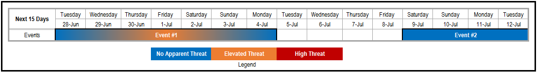
You’ll notice in the threat timeline at the top of the page, that Event #1 is a gradient of “No Apparent Threat” and “Elevated Threat.” I did this to give a visual note on how the threat will evolve. The first two days (Tuesday/Wednesday, June 28/29), will precede the deepest moisture moving in from the southwest. The end of the week and into the weekend (June 30 – July 3) will see the best combination of moisture/instability/disturbances, thus the transition to the “Elevated Flood Threat.” By Monday (July 4), the moisture will subside and dry westerly flow will be overhead, once again.
After the warming and drying period of Tuesday through Friday (July 5 – July 8), the next moisture surge awaits. Meanwhile, the persistent upper-level low will not be persistent anymore; instead, it will slide eastward along the US/Canada border. Depending on its eventual track will determine how much upper-level support is available for showers/thunderstorms. This will be monitored closely in the coming days. Also, there are hints in the extended range of tropical cyclone activity in the eastern North Pacific, which could have profound impacts in the extended range. As evidenced by the explanation above, there is some uncertainty surrounding the time frame of Event #2, so be sure and check back in with the FTO on Thursday.
Event #1: Tuesday (06-28-2016) through Monday (07-04-2016)
Elevated Flood Threat as First Monsoonal Moisture Surge Arrives
Awaiting the arrival of the main moisture surge, the first two days of this period will see progressively more shower/thunderstorm coverage. Temperature/dewpoint spreads in the low-levels suggest the heavy rain threat will be isolated through Wednesday. By Thursday, and lasting through Sunday, the moisture will be sufficiently deep enough to support scattered heavy rain events across much of the state as disturbances pivot across the region. Moisture will subside by late Sunday/early Monday, and dry westerly flow will be overhead.

Event #2: Saturday (07-09-2016) through Tuesday (07-12-2016)
No Apparent Flood Threat due to Uncertainty Surrounding Key Features
The upper-level low’s movement, timing of the next moisture surge, and any potential tropical cyclone activity in the eastern North Pacific are key factors in the extended range. Uncertainty exists with all three, and all will be monitored closely. Regardless, this looks to be the next opportunity for a wet period. Keep in mind that the precipitation map below represents the current thinking and will likely need adjustments moving forward. Stay tuned.