FTO 07-14-2016: Extended Elevated Flood Threat as Monsoon Returns

Issue Date: 7/14/2016
Issue Time: 12:50 PM

Threat_Timeline_20160714

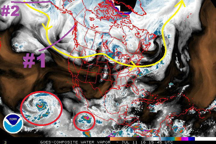
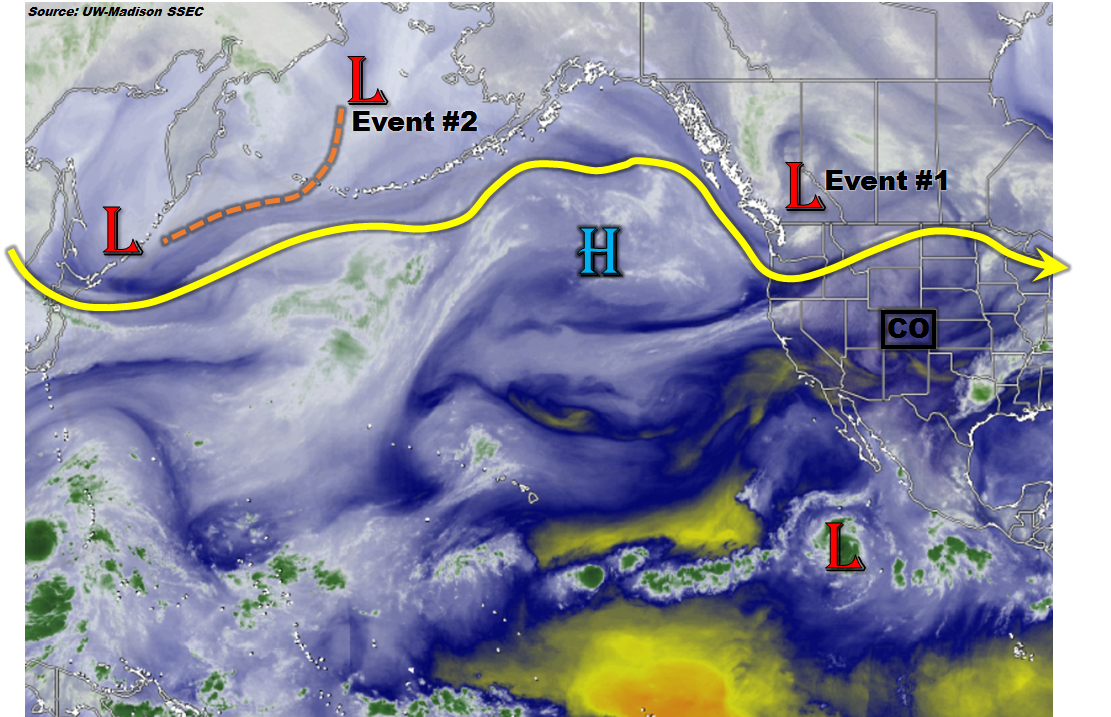
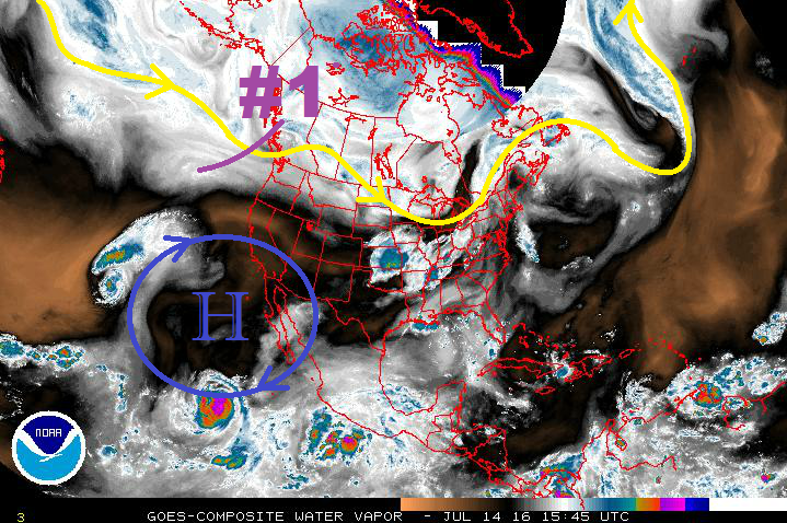
Event #1 will be the result of a mid-level disturbance (purple #1 in water vapor image below) swinging across the state within the northwest flow aloft, while modest low-level moisture remains in place across eastern Colorado. Enough instability will combine with modest wind shear to organize a few strong/severe thunderstorms across the eastern plains/Palmer Ridge regions. Isolated showers/thunderstorms will also be possible across the Front Range and Southeast Mountains, with lesser moisture in those locations tempering rain rates. To the west, warm and dry conditions are expected to continue.

WV_20160714

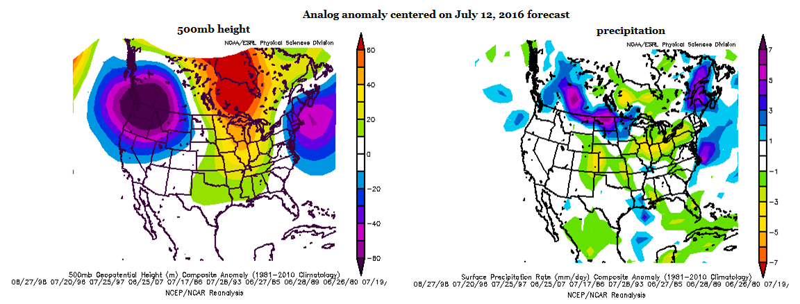
Changes are on the way for next week, beginning as early as Sunday, as low pressure strengthens over the Pacific Northwest coast and the strong high pressure center builds across the southwestern US. The movement of the high pressure center will allow for the reintroduction of some monsoonal moisture into western Colorado (Event #2). Moisture will become better through the midweek as the ridge shifts over the central US. Rounds of afternoon/evening showers and thunderstorms will continue throughout the week and into the next week, and the pattern sticks around until the end of this FTO period. This event, due to its duration and “rinse and repeat” nature, will be given the “Elevated Flood Threat” tag. Antecedent conditions are very important to western slope flood threats, and this pattern supports the threat.

On the other hand, for areas east of the Divide, the high pressure center will be too strong and likely too far north for meaningful moisture to enter the region. Instead, the moisture will be focused across western Colorado, and circled into Wyoming and Nebraska/South Dakota. Temperatures will climb as strong daytime heating prospers under the upper-level ridge, and gusty, downslope winds will help keep the low-levels dry. With these conditions in place, fire weather concerns will become elevated for areas along and east of the Front Range/Southeast Mountains.

The extended range is not completely bleak, though: The far Northeast Plains, Palmer Ridge, and Southeast Plains may get in on sporadic thunderstorms during the late afternoons/evenings/overnights, especially if an outflow boundary can back into the region from thunderstorms over Nebraska/Kansas. Additionally, a couple showers/high-based thunderstorms may drift over lower elevations adjacent to the mountains.

Some changes to the pattern may be on the way for the end of the period, with a trough deepening along the west coast and northwest flow aloft returning, along with south-southeasterly surface flow and Gulf moisture. This will be monitored in upcoming FTO’s.

Event #1: Friday (07-17-2016)

Elevated Flood Threat East of the Continental Divide

Low-level moisture combined with an upslope component to the wind field, strong daytime heating, and sufficient wind shear will allow for the development of isolated-to-scattered thunderstorms, mainly along and east of the Front Range/Southeast Mountains. Heavy rainfall will be a threat from stronger thunderstorms, and a few severe thunderstorms will produce strong winds/large hail, as well. Stay tuned to the FTB issued tomorrow morning.

Legend

Event #2: Tuesday (07-19-2016) through Friday (07-29-2016)

Elevated Flood Threat as Pattern Becomes “Stuck”

Most of the precipitation will remain over the High Country, with a few storms spilling over the Urban Corridor and adjacent plains. Additionally, sporadic thunderstorms will be possible across far eastern Colorado, especially if outflow boundaries from Nebraska/Kansas can back into the region. The strong high pressure will be slow to budge, allowing this pattern to stick around for an extended period of time. Some changes will be on the way towards the end of the period, but uncertainty surrounds their appearance. Continued rounds of afternoon/evening showers and thunderstorms over the High Country are the main concern with regards to a flood threat. Antecedent conditions, along with area burn scars (both old and new), will be important to monitor for any daily flood threats.

Legend

FTO 07-11-2016: Return of the Monsoon in the Extended Range

Issue Date: 7/11/2016
Issue Time: 1:20 PM

Threat_Timeline_20160711

The water vapor imagery tells the tale of the last few days, as well as the next few, with the large, dry airmass sitting overtop the southwestern US and extending back over the eastern Pacific Ocean. Changes are afoot beginning Wednesday night, however, as Event #1 begins to setup. The upper-level low/trough associated with Event #1 is denoted in the water vapor image below, and will continue to dig along the west coast over the next few days. Initially, it will eject a disturbance across the northern Rockies/plains, pushing a cool front through eastern Colorado on Wednesday night/Thursday morning. Behind this cool front, moisture will return to eastern Colorado. The moisture return, coupled with other factors, will bring about an elevated flood threat for Thursday (7/14) and Friday (7/15). More details on this event can be found in the event discussions below.

WV_20160711

The main trough associated with Event #1 will then stall over the Pacific, right along the west coast. It will then be reinforced by the trough/upper-level low marked Event #2. As this occurs the low/trough will deepen along the West Coast and a strong High pressure ridge will develop over the central US. When this occurs, monsoonal moisture will be transported into Colorado via south/southwesterly flow aloft, presenting an extended wet period for the High Country/Western Slope. The appearance of this monsoonal moisture begins on Tuesday, July 19th, and continues through the remainder of the period. For eastern Colorado, hot conditions will be aplenty during this timeframe, with many locations across the eastern plains in the upper 90s and low 100s. A few showers/thunderstorms may spill over onto the Urban Corridor and adjacent plains. Again, for more information, please see the event specific discussions below.

Event #1: Thursday (07-14-2016) and Friday (07-17-2016)

Elevated Flood Threat East of the Continental Divide

A cool front will move through Colorado on Wednesday night into Thursday morning. Behind it, decent moisture will return to eastern Colorado. This moisture combined with an upslope component to the low-level wind field, strong daytime heating, and sufficient wind shear will allow for the development of scattered thunderstorms, mainly along and east of the Front Range/Southeast Mountains. A secondary moisture surge on Friday will provide another period of scattered showers and thunderstorms. Heavy rainfall will be a threat from stronger thunderstorms, and a few severe thunderstorms will produce strong winds/large hail, as well.

Legend

Event #2: Tuesday (07-19-2016) through Friday (07-22-2016)

No Apparent Flood Threat as Monsoonal Moisture Returns

In the absence of large-scale support, the monsoonal moisture that will finally make its return to Colorado will be left without a dancing partner. Instead, daily thunderstorms will be reliant on daytime heating, orographic support, and escaping the downfall of cloud cover that limits instability. At any rate, there are likely to be a couple strong thunderstorms capable of heavy rainfall, so this period bears watching; a flood threat may become apparent in the next FTO issued on Thursday. Most of the precipitation will remain over the High Country, with a few storms spilling over the Urban Corridor and adjacent plains.

Legend

Event #3: Saturday (07-23-2016) through Tuesday (07-26-2016)

No Apparent Flood Threat, but Watchful Eye Necessary

Monsoonal moisture will look to continue its stay in Colorado, allowing for continued rounds of afternoon/evening showers and thunderstorms over the High Country. Much like Event #2, a few will spill over the Urban Corridor and adjacent plains. With a prolonged wet period, antecedent conditions will be important to monitor for any daily flood threats.

Legend

FTO 07-07-2016: Three Events, No Apparent Flood Threats

Issue Date: 7/7/2016
Issue Time: 1:45 PM

Threat_Timeline_20160707

Before we jump into discussing this week’s precipitation, it is important to discuss the underlying conditions that have developed over the last month or so. The image below shows the June 2016 Palmer Z-index for Colorado, which details how monthly moisture conditions depart from normal; think short-term drought and wetness. Generally speaking, areas east of the Continental Divide have fared the best, and this should not be a surprise. We spent quit a bit of last month, at least during moist periods, under northwesterly flow aloft, which typically favors areas east of the Divide and over the Plains.

PalmerZ_June2016

Along and west of the Continental Divide has been a different story, resulting in the introduction of short-term, or “flash” drought conditions. This is important to consider moving forward through this time period, because there does not appear to be much relief in the way of moisture for western areas. With the dry fuels in place, fire weather concerns will be heightened; especially next work week under a building ridge of high pressure that will allow temperatures to climb.

As for the “Flood Threat” portion of this outlook, there isn’t an apparent flood threat to be found, though there are three “events” to be discussed. The main storm track is well north of Colorado (typical of summertime), and our chances essentially hang on the timing/strength of any monsoonal moisture surges.

WV_20160707

As of right now, that moisture is being siphoned off into the Pacific Ocean as the Eastern Pacific comes to life with tropical cyclones. The westernmost purple circle highlights Hurricane Blas, a Category 3 Hurricane. The easternmost purple circle denotes Tropical Depression Four-E; it will likely become a named Tropical Storm by Friday, and then a Hurricane on Sunday.
For discussions regarding the individual events, please see the event discussions below.

Event #1: Friday (07-08-2016) through Sunday (07-10-2016)

No Apparent Flood Threat as a Typical Summertime Pattern Gears Up

Moisture will return to eastern Colorado as weak, low surface pressure remains persistent along the leeward side of the Rockies, owing to the westerly flow aloft. This will back the moisture into eastern Colorado, allowing a dryline to set up across the eastern plains. On Sunday, a weak cool front will move out of Wyoming and across the region, making Sunday the most active day of the event. This is relatively speaking, of course, as only isolated-to-scattered showers/thunderstorms are expected. Moisture, while it will make its return in the mid-levels, will still be meager in the lower-levels, and heavy rain will be hard to come by. No precipitation map is needed because totals will likely stay below the 0.5 inch threshold.

Event #2: Friday (07-15-2016) and Saturday (07-16-2016)

No Apparent Flood Threat as a Quick-Hitting Disturbance Finds a Little Better Moisture

The longwave trough oriented northeast-to-southwest across the Gulf of Alaska will eject a quick-hitting shortwave disturbance during this timeframe. Southerly flow will bring Gulf moisture closer to the I-25 corridor than during Event #1, allowing for a little bit better shot at strong thunderstorms/heavy rainfall. The heaviest rain will remain east, where flash flood thresholds are higher. Thus, no apparent flood threat.

Legend

Event #3: Wednesday (07-20-2016) through Friday (07-22-2016)

No Apparent Flood Threat, but Could This Be the Next Monsoonal Surge?

With the aforementioned fire weather concerns, the next monsoonal surge will be anxiously awaited. It appears that this timeframe may be the next chance at a good moisture surge, and will bring the chance for scattered-to-widespread showers/thunderstorms back to western Colorado. There is uncertainty surrounding this timeframe, as models have waffled back and forth between surge/no surge. Stay tuned to the next FTO on Monday for another look at this event.

FTO 07-04-2016: Hit Or (Mostly) Miss Rainfall This Week; Then Waiting For The Next Monsoon Surge

Issue Date: Monday, July 4th, 2016
Issue Time: 12:00PM MDT

threat_timeline

For this edition of the Flood Threat Outlook (FTO), we first look at what has occurred over the past week or so. The three-panel maps below show the 500mb height, air temperature and precipitation anomalies across the United States over the past week. As roughly expected in previous FTOs, a ridge with moderate intensity has been positioned over the North American west coast. This position is far enough northwest of Colorado that disturbances were able to pass through both from the north and south, contributing to well above normal rainfall across the state over that time. The northwest states have seen very warm weather but our temperatures have remained close to seasonal averages after a rather warm June. The other major weather news was the first coordinated surge of monsoon moisture, which brought welcome shower and storm activity to our western slope. Fortunately, flooding was largely avoided as rainfall amounts were of the light to moderate variety.

past_week_tripanelNow we transition to this morning’s weather map, as shown by the water vapor image below. Notice that the northwest US ridge has been replaced in dramatic fashion by a strong low-pressure disturbance. Part of this disturbance will quickly swing by the northern Rocky Mountain states, setting up a rather uneventful Event #1. Then, looking farther to the west, we spot Event #2 as a low pressure system currently west of Alaska. This is expected to enter the northwest US coast late this week, but again, despite it being classified as an “event”, widespread heavy rainfall is not expected. In general, disturbances that move in a westerly fashion across the northern Rocky Mountain states are extremely unfavorable to rainfall in CO due to a lack of return flow and in this case, very fast propagation speed.

wv_markup

As we look farther out, the left map below shows that the northwest US disturbance seen in the water vapor image above is more-or-less expected to stick around for the next 6-10 days. For Colorado, this will result in a transport of warm, dry air from the eastern Pacific subtropical high. Thus, as shown in the right map, below, the analog method suggests much drier than normal conditions through the next week to 10 days. Thereafter, there is enough guidance to suggest that another large-scale monsoon surge will develop and affect the southwest US. This has been marked as Event #3 in this FTO. If this comes to fruition, there will certainly be enough potential for an elevated flood threat. However, at this point, no apparent threat is seen until there is more consensus that the monsoon surge will indeed occur.

8day_forecast_analogBelow, each of the three events discussed above is described in more detail.

Event #1: Tuesday (7/5) through Wednesday (7/6)

No Apparent Flood Threat

A fast moving disturbance will affect mainly northern Colorado on Tuesday (7/5) and Wednesday (7/6). Fast storm motion and marginal instability will combine to keep rainfall in the 0.25 – 0.5 inch range. Gusty winds and lightning may be the more impactful threat.

Event #2: Sunday (7/10) through Monday (7/11)

No Apparent Flood Threat

Another fast moving “westerly flow” disturbance will likely affect northern areas of the state late this weekend. At this time, this event looks similar to Event #1 with a general 0.25 to 0.5 inches of rainfall possible for lucky locations. It is possible that the tail end of this event could see more substantial rainfall, but this will require the disturbance to take a more southeasterly dive. If that occurs, the residual cool front and moisture could affect the state for an additional day of rainfall. However, at this time, this looks quite unlikely with the more likely scenario being the disturbance racing off to the east-northeast of our state.

Event #3: Saturday (7/16) through Monday (7/18)

No Apparent Flood Threat at this time, but this event has the potential to be upgraded

After a prolonged hiatus of seasonably warm and mostly dry weather, guidance suggests that things could turn interesting into the weekend of Saturday 7/16. A moderate intensity ridge looks to quickly break down and transition far enough east of Colorado to open the gates for a strong push of monsoon moisture originating off the Gulf of Mexico and the Mexican west coast. If this is the case, a multi-day period of unsettled weather will likely affect western Colorado and possibly spread eastward across the Continental Divide. At this time, we are conservatively showing the potential of a wide swath of 1.0 – 1.5 inch rainfall especially for the climatologically favored San Juans. Once it becomes clear that this monsoon surge will indeed occur, this estimate will likely need to be upped. Until then, there is no apparent flood threat.


Legend