Issue Date: 7/7/2016
Issue Time: 1:45 PM

Before we jump into discussing this week’s precipitation, it is important to discuss the underlying conditions that have developed over the last month or so. The image below shows the June 2016 Palmer Z-index for Colorado, which details how monthly moisture conditions depart from normal; think short-term drought and wetness. Generally speaking, areas east of the Continental Divide have fared the best, and this should not be a surprise. We spent quit a bit of last month, at least during moist periods, under northwesterly flow aloft, which typically favors areas east of the Divide and over the Plains.
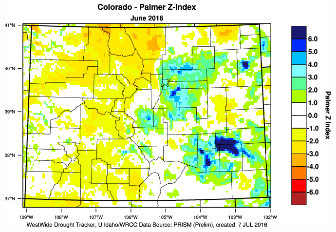
Along and west of the Continental Divide has been a different story, resulting in the introduction of short-term, or “flash” drought conditions. This is important to consider moving forward through this time period, because there does not appear to be much relief in the way of moisture for western areas. With the dry fuels in place, fire weather concerns will be heightened; especially next work week under a building ridge of high pressure that will allow temperatures to climb.
As for the “Flood Threat” portion of this outlook, there isn’t an apparent flood threat to be found, though there are three “events” to be discussed. The main storm track is well north of Colorado (typical of summertime), and our chances essentially hang on the timing/strength of any monsoonal moisture surges.
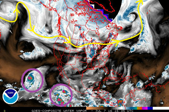
As of right now, that moisture is being siphoned off into the Pacific Ocean as the Eastern Pacific comes to life with tropical cyclones. The westernmost purple circle highlights Hurricane Blas, a Category 3 Hurricane. The easternmost purple circle denotes Tropical Depression Four-E; it will likely become a named Tropical Storm by Friday, and then a Hurricane on Sunday.
For discussions regarding the individual events, please see the event discussions below.
Event #1: Friday (07-08-2016) through Sunday (07-10-2016)
No Apparent Flood Threat as a Typical Summertime Pattern Gears Up
Moisture will return to eastern Colorado as weak, low surface pressure remains persistent along the leeward side of the Rockies, owing to the westerly flow aloft. This will back the moisture into eastern Colorado, allowing a dryline to set up across the eastern plains. On Sunday, a weak cool front will move out of Wyoming and across the region, making Sunday the most active day of the event. This is relatively speaking, of course, as only isolated-to-scattered showers/thunderstorms are expected. Moisture, while it will make its return in the mid-levels, will still be meager in the lower-levels, and heavy rain will be hard to come by. No precipitation map is needed because totals will likely stay below the 0.5 inch threshold.
Event #2: Friday (07-15-2016) and Saturday (07-16-2016)
No Apparent Flood Threat as a Quick-Hitting Disturbance Finds a Little Better Moisture
The longwave trough oriented northeast-to-southwest across the Gulf of Alaska will eject a quick-hitting shortwave disturbance during this timeframe. Southerly flow will bring Gulf moisture closer to the I-25 corridor than during Event #1, allowing for a little bit better shot at strong thunderstorms/heavy rainfall. The heaviest rain will remain east, where flash flood thresholds are higher. Thus, no apparent flood threat.

Event #3: Wednesday (07-20-2016) through Friday (07-22-2016)
No Apparent Flood Threat, but Could This Be the Next Monsoonal Surge?
With the aforementioned fire weather concerns, the next monsoonal surge will be anxiously awaited. It appears that this timeframe may be the next chance at a good moisture surge, and will bring the chance for scattered-to-widespread showers/thunderstorms back to western Colorado. There is uncertainty surrounding this timeframe, as models have waffled back and forth between surge/no surge. Stay tuned to the next FTO on Monday for another look at this event.