Issue Date: Monday, July 4th, 2016
Issue Time: 12:00PM MDT

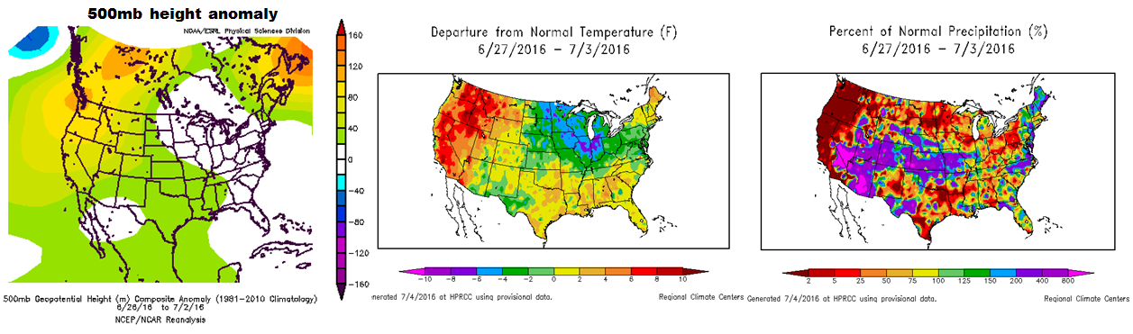
For this edition of the Flood Threat Outlook (FTO), we first look at what has occurred over the past week or so. The three-panel maps below show the 500mb height, air temperature and precipitation anomalies across the United States over the past week. As roughly expected in previous FTOs, a ridge with moderate intensity has been positioned over the North American west coast. This position is far enough northwest of Colorado that disturbances were able to pass through both from the north and south, contributing to well above normal rainfall across the state over that time. The northwest states have seen very warm weather but our temperatures have remained close to seasonal averages after a rather warm June. The other major weather news was the first coordinated surge of monsoon moisture, which brought welcome shower and storm activity to our western slope. Fortunately, flooding was largely avoided as rainfall amounts were of the light to moderate variety.
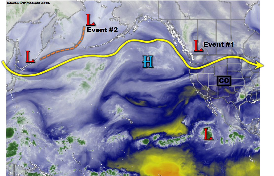
 Now we transition to this morning’s weather map, as shown by the water vapor image below. Notice that the northwest US ridge has been replaced in dramatic fashion by a strong low-pressure disturbance. Part of this disturbance will quickly swing by the northern Rocky Mountain states, setting up a rather uneventful Event #1. Then, looking farther to the west, we spot Event #2 as a low pressure system currently west of Alaska. This is expected to enter the northwest US coast late this week, but again, despite it being classified as an “event”, widespread heavy rainfall is not expected. In general, disturbances that move in a westerly fashion across the northern Rocky Mountain states are extremely unfavorable to rainfall in CO due to a lack of return flow and in this case, very fast propagation speed.
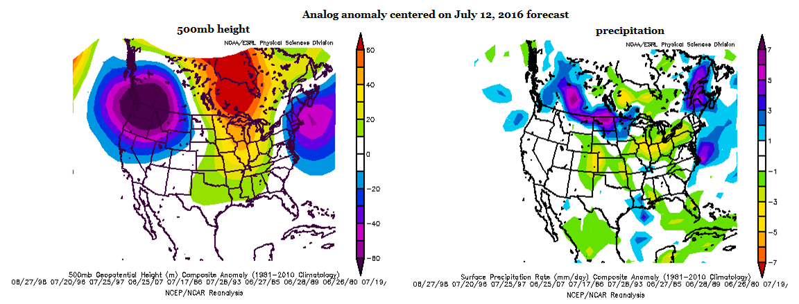
As we look farther out, the left map below shows that the northwest US disturbance seen in the water vapor image above is more-or-less expected to stick around for the next 6-10 days. For Colorado, this will result in a transport of warm, dry air from the eastern Pacific subtropical high. Thus, as shown in the right map, below, the analog method suggests much drier than normal conditions through the next week to 10 days. Thereafter, there is enough guidance to suggest that another large-scale monsoon surge will develop and affect the southwest US. This has been marked as Event #3 in this FTO. If this comes to fruition, there will certainly be enough potential for an elevated flood threat. However, at this point, no apparent threat is seen until there is more consensus that the monsoon surge will indeed occur.
 Below, each of the three events discussed above is described in more detail.
Event #1: Tuesday (7/5) through Wednesday (7/6)
No Apparent Flood Threat
A fast moving disturbance will affect mainly northern Colorado on Tuesday (7/5) and Wednesday (7/6). Fast storm motion and marginal instability will combine to keep rainfall in the 0.25 – 0.5 inch range. Gusty winds and lightning may be the more impactful threat.
Event #2: Sunday (7/10) through Monday (7/11)
No Apparent Flood Threat
Another fast moving “westerly flow” disturbance will likely affect northern areas of the state late this weekend. At this time, this event looks similar to Event #1 with a general 0.25 to 0.5 inches of rainfall possible for lucky locations. It is possible that the tail end of this event could see more substantial rainfall, but this will require the disturbance to take a more southeasterly dive. If that occurs, the residual cool front and moisture could affect the state for an additional day of rainfall. However, at this time, this looks quite unlikely with the more likely scenario being the disturbance racing off to the east-northeast of our state.
Event #3: Saturday (7/16) through Monday (7/18)
No Apparent Flood Threat at this time, but this event has the potential to be upgraded
After a prolonged hiatus of seasonably warm and mostly dry weather, guidance suggests that things could turn interesting into the weekend of Saturday 7/16. A moderate intensity ridge looks to quickly break down and transition far enough east of Colorado to open the gates for a strong push of monsoon moisture originating off the Gulf of Mexico and the Mexican west coast. If this is the case, a multi-day period of unsettled weather will likely affect western Colorado and possibly spread eastward across the Continental Divide. At this time, we are conservatively showing the potential of a wide swath of 1.0 – 1.5 inch rainfall especially for the climatologically favored San Juans. Once it becomes clear that this monsoon surge will indeed occur, this estimate will likely need to be upped. Until then, there is no apparent flood threat.
