Issue Date: 7/11/2016
Issue Time: 1:20 PM

The water vapor imagery tells the tale of the last few days, as well as the next few, with the large, dry airmass sitting overtop the southwestern US and extending back over the eastern Pacific Ocean. Changes are afoot beginning Wednesday night, however, as Event #1 begins to setup. The upper-level low/trough associated with Event #1 is denoted in the water vapor image below, and will continue to dig along the west coast over the next few days. Initially, it will eject a disturbance across the northern Rockies/plains, pushing a cool front through eastern Colorado on Wednesday night/Thursday morning. Behind this cool front, moisture will return to eastern Colorado. The moisture return, coupled with other factors, will bring about an elevated flood threat for Thursday (7/14) and Friday (7/15). More details on this event can be found in the event discussions below.
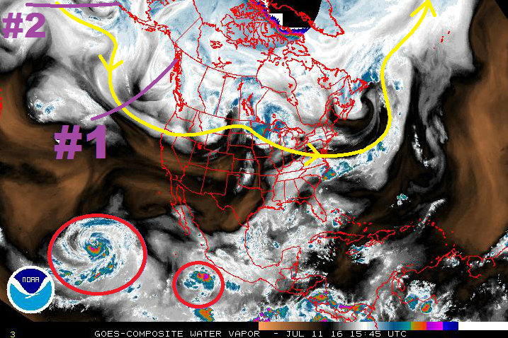
The main trough associated with Event #1 will then stall over the Pacific, right along the west coast. It will then be reinforced by the trough/upper-level low marked Event #2. As this occurs the low/trough will deepen along the West Coast and a strong High pressure ridge will develop over the central US. When this occurs, monsoonal moisture will be transported into Colorado via south/southwesterly flow aloft, presenting an extended wet period for the High Country/Western Slope. The appearance of this monsoonal moisture begins on Tuesday, July 19th, and continues through the remainder of the period. For eastern Colorado, hot conditions will be aplenty during this timeframe, with many locations across the eastern plains in the upper 90s and low 100s. A few showers/thunderstorms may spill over onto the Urban Corridor and adjacent plains. Again, for more information, please see the event specific discussions below.
Event #1: Thursday (07-14-2016) and Friday (07-17-2016)
Elevated Flood Threat East of the Continental Divide
A cool front will move through Colorado on Wednesday night into Thursday morning. Behind it, decent moisture will return to eastern Colorado. This moisture combined with an upslope component to the low-level wind field, strong daytime heating, and sufficient wind shear will allow for the development of scattered thunderstorms, mainly along and east of the Front Range/Southeast Mountains. A secondary moisture surge on Friday will provide another period of scattered showers and thunderstorms. Heavy rainfall will be a threat from stronger thunderstorms, and a few severe thunderstorms will produce strong winds/large hail, as well.

Event #2: Tuesday (07-19-2016) through Friday (07-22-2016)
No Apparent Flood Threat as Monsoonal Moisture Returns
In the absence of large-scale support, the monsoonal moisture that will finally make its return to Colorado will be left without a dancing partner. Instead, daily thunderstorms will be reliant on daytime heating, orographic support, and escaping the downfall of cloud cover that limits instability. At any rate, there are likely to be a couple strong thunderstorms capable of heavy rainfall, so this period bears watching; a flood threat may become apparent in the next FTO issued on Thursday. Most of the precipitation will remain over the High Country, with a few storms spilling over the Urban Corridor and adjacent plains.
Event #3: Saturday (07-23-2016) through Tuesday (07-26-2016)
No Apparent Flood Threat, but Watchful Eye Necessary
Monsoonal moisture will look to continue its stay in Colorado, allowing for continued rounds of afternoon/evening showers and thunderstorms over the High Country. Much like Event #2, a few will spill over the Urban Corridor and adjacent plains. With a prolonged wet period, antecedent conditions will be important to monitor for any daily flood threats.