Issue Date: 7/14/2016
Issue Time: 12:50 PM
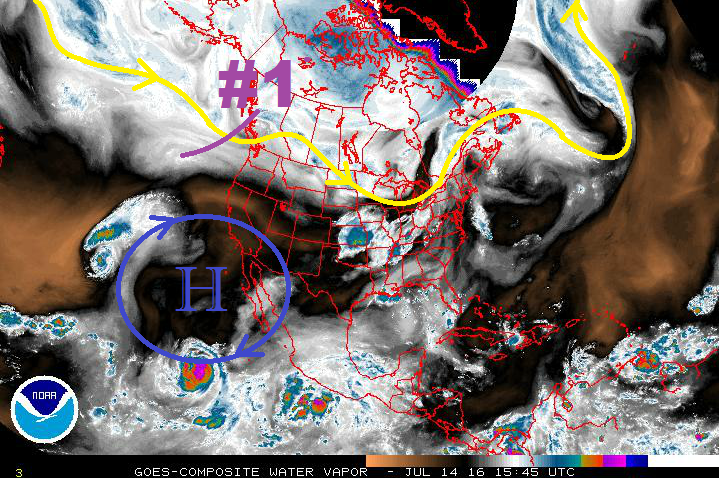
Event #1 will be the result of a mid-level disturbance (purple #1 in water vapor image below) swinging across the state within the northwest flow aloft, while modest low-level moisture remains in place across eastern Colorado. Enough instability will combine with modest wind shear to organize a few strong/severe thunderstorms across the eastern plains/Palmer Ridge regions. Isolated showers/thunderstorms will also be possible across the Front Range and Southeast Mountains, with lesser moisture in those locations tempering rain rates. To the west, warm and dry conditions are expected to continue.
Changes are on the way for next week, beginning as early as Sunday, as low pressure strengthens over the Pacific Northwest coast and the strong high pressure center builds across the southwestern US. The movement of the high pressure center will allow for the reintroduction of some monsoonal moisture into western Colorado (Event #2). Moisture will become better through the midweek as the ridge shifts over the central US. Rounds of afternoon/evening showers and thunderstorms will continue throughout the week and into the next week, and the pattern sticks around until the end of this FTO period. This event, due to its duration and “rinse and repeat” nature, will be given the “Elevated Flood Threat” tag. Antecedent conditions are very important to western slope flood threats, and this pattern supports the threat.
On the other hand, for areas east of the Divide, the high pressure center will be too strong and likely too far north for meaningful moisture to enter the region. Instead, the moisture will be focused across western Colorado, and circled into Wyoming and Nebraska/South Dakota. Temperatures will climb as strong daytime heating prospers under the upper-level ridge, and gusty, downslope winds will help keep the low-levels dry. With these conditions in place, fire weather concerns will become elevated for areas along and east of the Front Range/Southeast Mountains.
The extended range is not completely bleak, though: The far Northeast Plains, Palmer Ridge, and Southeast Plains may get in on sporadic thunderstorms during the late afternoons/evenings/overnights, especially if an outflow boundary can back into the region from thunderstorms over Nebraska/Kansas. Additionally, a couple showers/high-based thunderstorms may drift over lower elevations adjacent to the mountains.
Some changes to the pattern may be on the way for the end of the period, with a trough deepening along the west coast and northwest flow aloft returning, along with south-southeasterly surface flow and Gulf moisture. This will be monitored in upcoming FTO’s.
Event #1: Friday (07-17-2016)
Elevated Flood Threat East of the Continental Divide
Low-level moisture combined with an upslope component to the wind field, strong daytime heating, and sufficient wind shear will allow for the development of isolated-to-scattered thunderstorms, mainly along and east of the Front Range/Southeast Mountains. Heavy rainfall will be a threat from stronger thunderstorms, and a few severe thunderstorms will produce strong winds/large hail, as well. Stay tuned to the FTB issued tomorrow morning.
Event #2: Tuesday (07-19-2016) through Friday (07-29-2016)
Elevated Flood Threat as Pattern Becomes “Stuck”
Most of the precipitation will remain over the High Country, with a few storms spilling over the Urban Corridor and adjacent plains. Additionally, sporadic thunderstorms will be possible across far eastern Colorado, especially if outflow boundaries from Nebraska/Kansas can back into the region. The strong high pressure will be slow to budge, allowing this pattern to stick around for an extended period of time. Some changes will be on the way towards the end of the period, but uncertainty surrounds their appearance. Continued rounds of afternoon/evening showers and thunderstorms over the High Country are the main concern with regards to a flood threat. Antecedent conditions, along with area burn scars (both old and new), will be important to monitor for any daily flood threats.


