FTO 07-07-2022: Break in Rainfall This Weekend with Extreme Heat Forecast

Issue Date: Thursday, July 7th, 2022
Issue Time: 3PM MDT
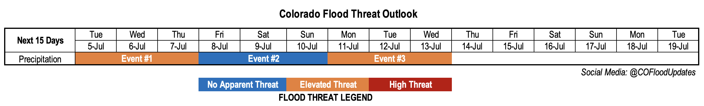
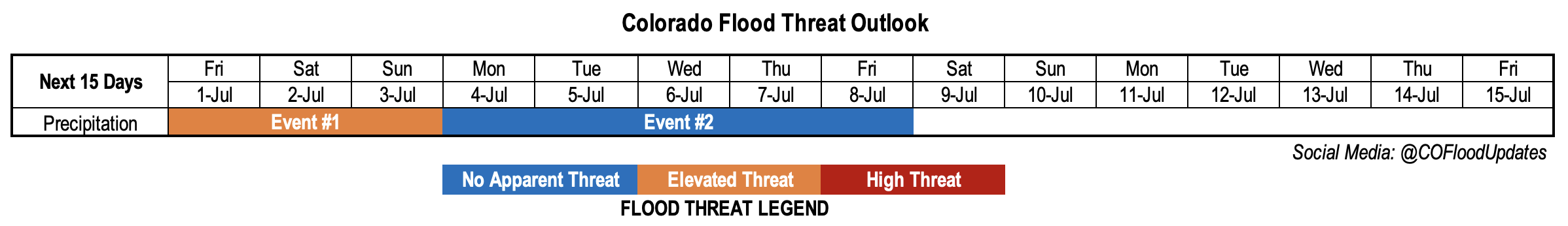
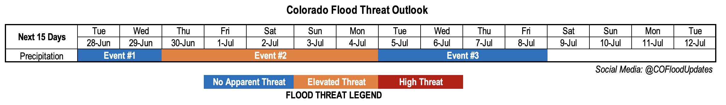
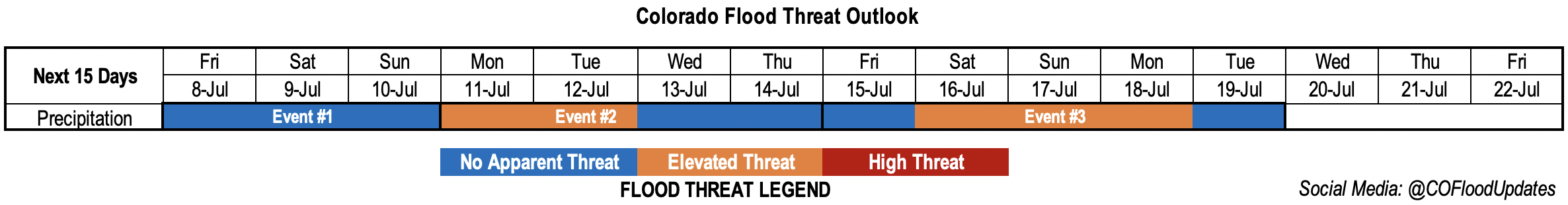
Valid Dates: 7/8 – 7/22

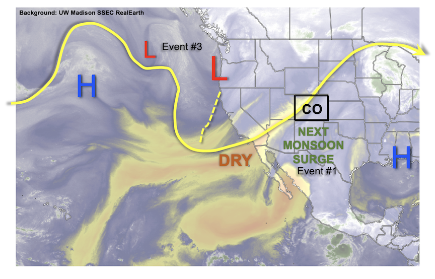
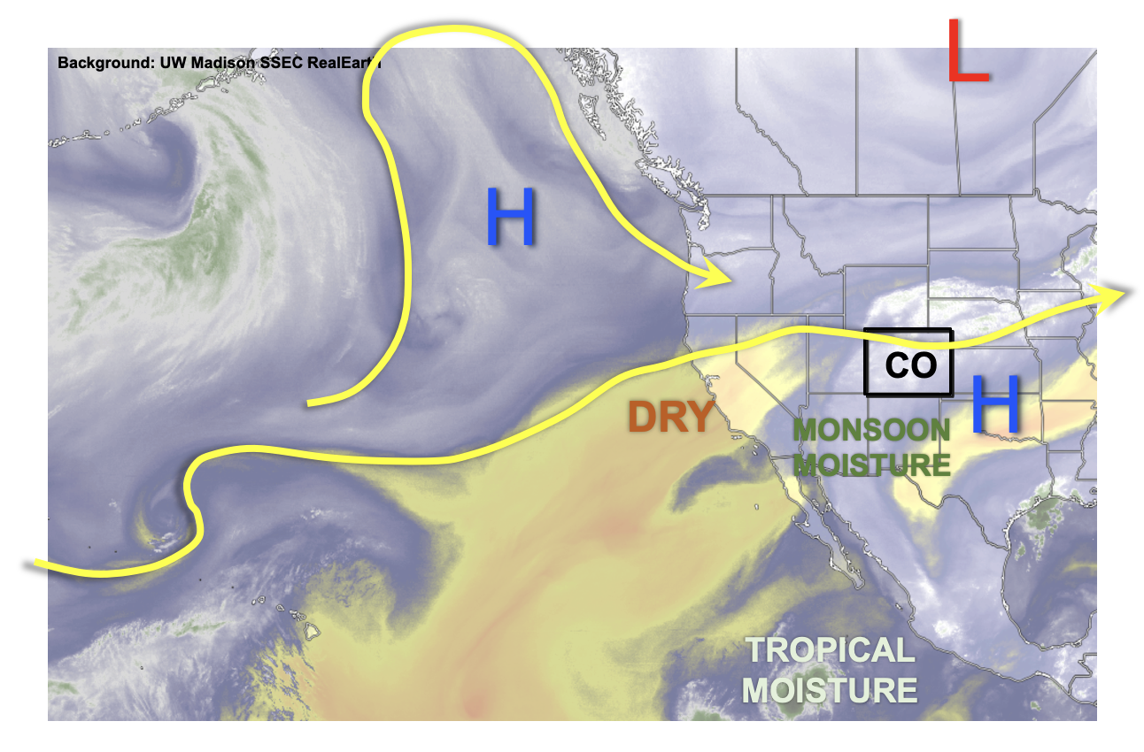
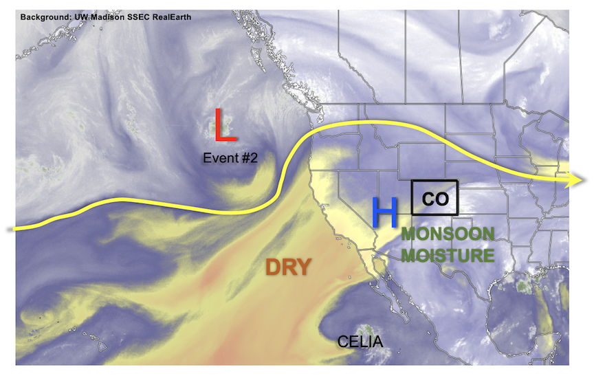
Looking at the water vapor imagery below, there are two very distinctive air masses over the state with more moisture located along and to the east of the green arrows. Dry southwesterly flow is forecast to increase through tomorrow, and paired with a building High pressure axis to our west and north, hot temperatures and minimal rainfall are forecast for this weekend (Event #1). Just how hot will it get? Guidance is showing high temperatures as high as 15-18°F above normal, so there could be some daily temperature records broken. Afternoon high temperatures across the eastern plains and western valleys could reach between 100-105°F, so expect to see some excessive heat advisories to be issued.

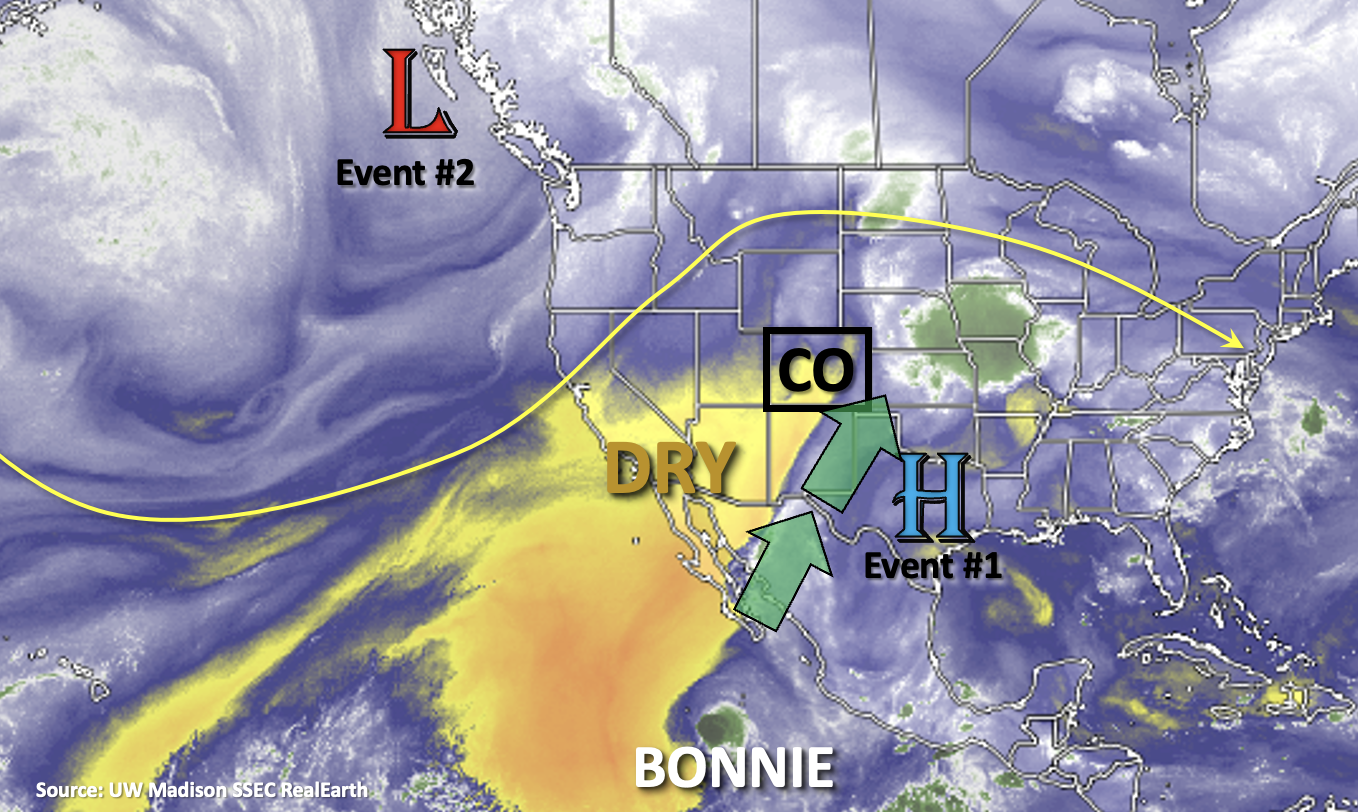
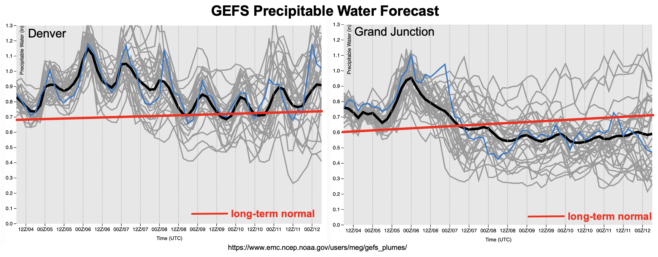
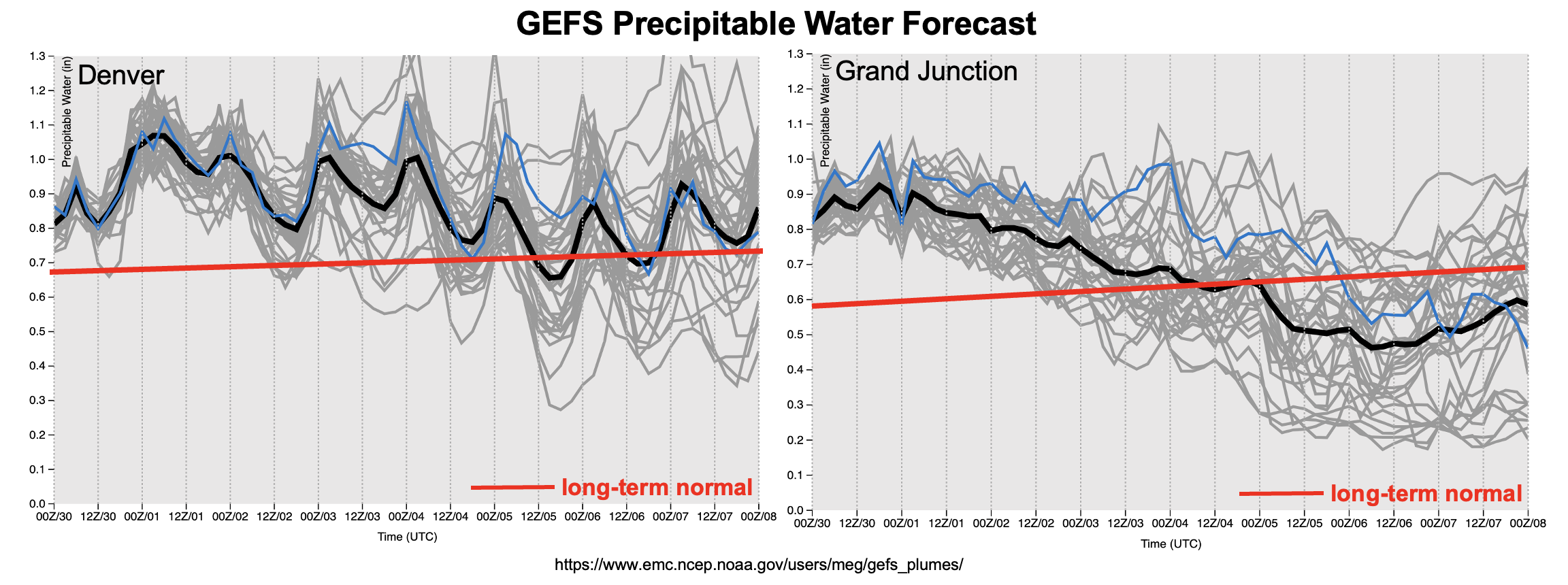
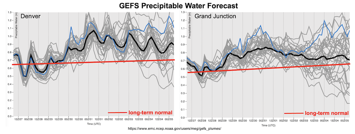
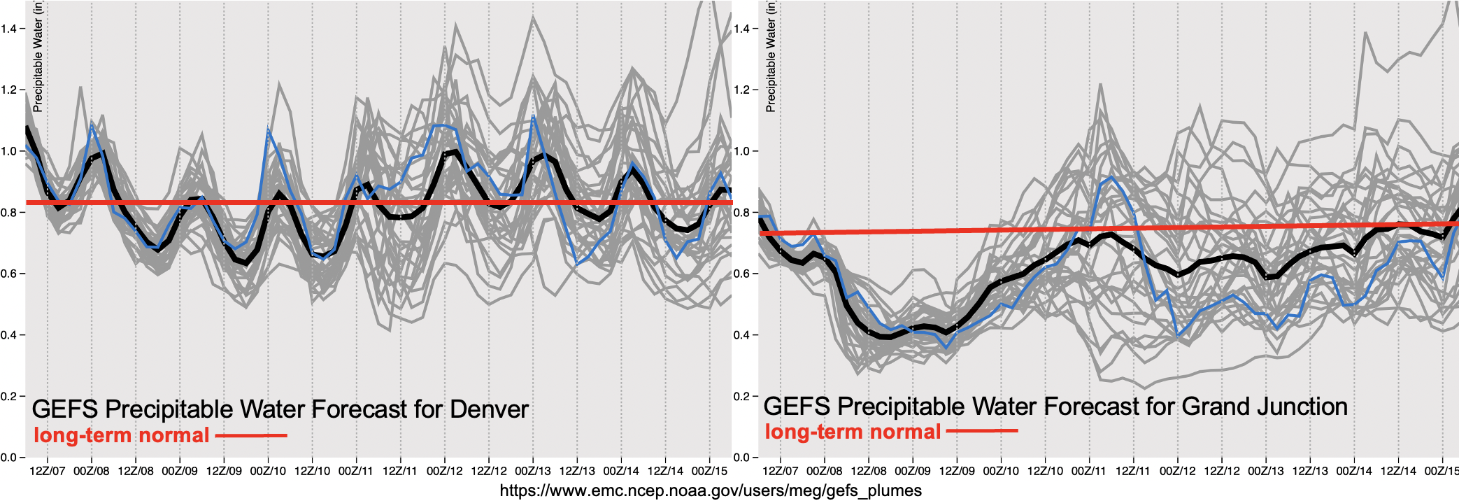
The Low shown off the west coast is forecast to slowly break down the ridge by late this weekend and into early next week. This will allow the trough to pass to our north and return cooler temperatures to start the work week behind a cold front. Higher moisture return is expected over eastern Colorado as shown by normal to below average values in the PW plumes below, which will cause an Elevated flood threat to be issued for the start of Event #2. Moisture return over western Colorado is less certain, but there will likely be an uptick in storm coverage over the southern high terrains during this period.

The ridge axis will then begin to rebuild to our west before moving directly overhead by mid-next week, which will place Colorado in an unfavorable position for moisture transport. This should cause a downtick in afternoon storm coverage as well as flooding potential, which is shown by a slight decrease in the average PW plume over Denver below.

Event #3 likely begins at the end of next week as another Low moves off the west coast and pushes the ridge axis to our east. This is typically a favorable pattern for moisture return, therefore an Elevated flood threat has been issued.

Event #1: Friday – Sunday (7/87/10)

No Apparent Threat as subsidence and drying keeps only isolated precipitation chances in the forecast.

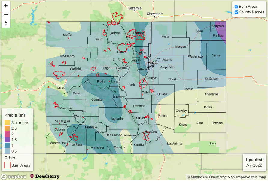
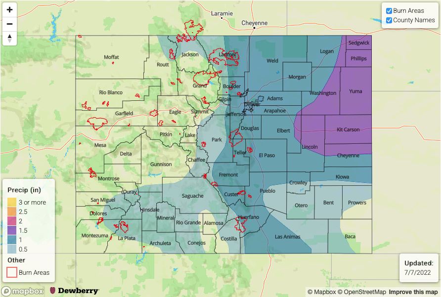
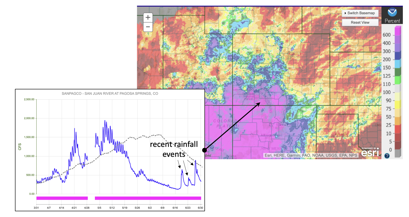
As is typical during monsoon season, residual moisture often gets trapped underneath the ridging pattern. While drying trends occur between systems, there is typically enough residual moisture to produce at least weak rainfall over the mountains with our diurnal heating pattern. That is exactly what will happen this weekend, which means that a few lucky spots (likely south) will get a small break from the heat. However, with the dry surface layer, virga and cloud cover will be more likely along with brief outflow winds from storms that develop. Max 30-minute rainfall rates around 0.40 inches look to be possible, so flooding is NOT expected. Due to the more isolated nature of the rainfall this weekend and totals likely remaining under 0.5 inches, no precipitation map has been drawn.

Event #2: Monday – Thursday (7/117/14)

Elevated/No Apparent Threat flood threat as the ridge breaks down and a cold front returns moisture to eastern and central Colorado.

A cold front looks to drop south across the state sometime from late on Sunday into Monday, which should help return cooler temperatures behind it. It looks to stall out before making it fully across the state, so southern Colorado is forecast to remain hot. Moisture return looks decent over eastern and central Colorado, which means there will be an increased chance for precipitation in the afternoon and evenings. The transition to westerly and northwest flow aloft is also favorable for sending mid-level disturbances through the state, and with storms tracking to the adjacent eastern plains where moisture is higher, there will be an Elevated flood threat. Daily details will be tracked in the FTB, but it is likely the flood threat will only affect the adjacent eastern plains. More run of the mill rainfall and thunderstorms are forecast for the latter part of this event favoring the high terrains for accumulation.

Event #3: Friday – Tuesday (7/157/19)

Elevated/No Apparent Threat as subtropical moisture returns to the state.

Still a bit too far out to know all the details about Event #3, but there is consensus among guidance that the upper-level ridge axis will be pushed slightly eastward during this period. This is a favorable pattern for moisture advection across the state, so it is likely scattered to numerous storms will return to the forecast for the weekend. Slowing steering flow under the ridge should allow storms to produce higher accumulations, so an Elevated flood threat has been issued. Tune back into the FTO on Monday as the details of this event will likely evolve. Due to low confidence in the placement of precipitation this far out, no map has been drawn, but rainfall will likely favor the climatological hotspots: southern San Juan Mountains, Southeast Mountains, Raton Ridge & Palmer Ridge/southern Front Range intersect.

FTO 07-04-2022: Pesky Heavy Rainfall Threat To Persist; Brief Heat Wave Also On The Way

Issue Date: Monday, July 4th, 2022
Issue Time: 1:30PM MDT
Valid Dates: 7/5 – 7/18

Since last Thursday’s Outlook, there have been a couple of notable forecast changes for this Independence Day edition of the Outlook. First, the aforementioned statewide heat wave is still expected later this week, although its peak intensity and duration have (fortunately!) both trended in the less impressive direction. Second, the anticipated drying is also still on schedule, but it will be limited to mainly the northwest portion of the state and for a shorter duration, essentially leaving the rest of the state vulnerable to at least an isolated heavy rainfall threat for a prolonged stretch.

As shown in the water vapor image, below, the features dictating Colorado’s precipitation chances over the course of this Outlook are familiar ones during our summers. First, we note an upper-level ridge centered over the southeast US, which will promote moist, generally southerly flow over Colorado. This will be amplified by a rather strong trough just off the western North American coast. However, the trough itself will move little and actually retrogress (or move “against” the prevailing wind direction) back westward until early next week. Looking closer to home, a pulse of monsoonal moisture is aimed directly at Colorado setting up a 48-72 hour period of enhanced precipitation chances (Event #1). With PW values exceeding 1.5 inches entering AZ and NM, moisture will be once again aplenty over Colorado by Tuesday. Initially, it seemed that only the higher terrain will be the prime recipient of heavier rainfall and elevated flood threat. However, “spillover” moisture now seems like it will make it far enough eastward to bump up heavy rainfall potential over the Northeast Plains (and possibly Southeast Plains).

As shown in the forecast GEFS PW plumes, below, moisture will decrease statewide following Event #1, but especially over the northwest part of the state. Precipitation chances will follow suit, though isolated to widely scattered storms are still expected over mainly the central and southern higher terrain (Event #2). Flooding looks unlikely at this time, though given enough moisture, a low-end flood threat could emerge at relatively short notice (i.e. check in with daily Bulletins!). At the same time, the aforementioned upper-level ridge will expand quickly westward and build in strength to produce very hot temperatures for a 24-48 hour stretch next weekend. Fortunately, it does appear that the hot weather will be rather quickly extinguished as a passing of a Pacific cool front looks more likely either late this weekend or early next week. This will setup an increase in precipitation chances as well as heavy rainfall and elevated flooding potential (Event #3). Fortunately, it appears that almost all of eastern Colorado, which has stayed on the drier side during June, should see enhanced coverage of soaking rain. The finer details of Event #3 will still be determined over the next few days, but it suffices to say that no one will be complaining about the heat wave coming to an end so soon.

The identified precipitation events are described in more detail below.

Event #1: Tuesday – Thursday (July 5 – July 7)

Elevated Flood Threat Initially Over Southern/Central High Terrain, Possibly Spreading Over Plains

Widespread showers and thunderstorms are expected over mainly the San Juan and Central Mountains on Tuesday, and then expanding to the Northern Mountains by Wednesday and possibly Thursday. At least isolated short-term heavy rainfall looks likely, with max 30-minute intensity in the 0.8 – 1.0 inch and max 1-hour rainfall in the 1.2 – 1.6 inch range possible. Depending on subtler details such as how quickly the initial round of storms form, there could be a more prolonged 3 – 6 hour rainfall accumulation flood threat elevating the threat of debris slides and mud flows (in addition to flash flooding).

Further east, there is more uncertainty but isolated storms are looking more likely with the potential for marginally heavy rainfall up to 2 inches per hour. An isolated flash flood threat will exist if this materializes.

Event #2: Friday – Sunday (July 8 – July 10)

Storm Coverage And Intensity To Decrease As Heat Builds; No Apparent Flood Threat

Storm coverage and intensity should drop into the isolated to widely scattered variety as heat and subsidence temporarily dominated headlines. The best coverage will be where climatological terrain-induced circulations are most favorable: the Front Range, Central Mountains, San Juan Mountains and Southeast Mountains. Max 30-minute rainfall up to 0.5 inches looks possible, but flooding is currently not anticipated.

Event #3: Monday – Wednesday (July 11 – July 13)

Elevated Flood Threat Returns Mainly To Eastern/Central Colorado

A Pacific cool front is poised to move across northern and eastern Colorado sometime in the Sunday – Monday timeframe, which will set the stage for an increase in moisture, and more favorable dynamics for storm activity. Scattered to numerous showers and storms are expected over the Front Range, Palmer Ridge and Southeast Mountains with max 30-minute rainfall rates looking to exceed 0.8 inches per hour, warranting an elevated threat. Further east across the lower elevations, the character of the rainfall is more uncertain and will depend on instability, front passage timing and moisture. However, with frontal boundaries in place and an increase in PW into the 1.2+ inch range, max 1-hour rainfall exceeding 2.0 inches looks possible at this time, which also warrants a low-end Elevated threat for isolated flash flooding.

FTO 06-30-2022: Flood Threat Through The July 4th Weekend, Then Isolated Storms With Heat Building

Issue Date: Thursday, June 30th, 2022
Issue Time: 2PM MDT
Valid Dates: 7/1-7/15

Mother Nature could not have done a bigger favor for southwest Colorado this June. With the early snowmelt and dry spring conditions in the San Juan Mountains, all concerns were focused on the building drought and possible wildfire potential there. Instead, as shown below, a majority of the region received 200-500% of their normal June precipitation. Some of these statistics are probably an overly generous depiction of the wetness, given that June is a typically a drier transition month (i.e. the divide by a small number effect). Nonetheless, as shown below for the San Juan River as an example (note 3 recent rain-related spikes of 500, 200 and 600 c.f.s.), almost all major rivers in southwest Colorado saw multiple spikes in streamflow during a time when average streamflow is typically quickly receding post snow-melt.

Switching back from hindcast to forecast mode, the water vapor image, below, shows a continuation of a relatively familiar pattern the Colorado has witnessed for about 2 weeks now. A week upper-level ridge is centered over the US Great Plains, around which clockwise flow is continuously directing monsoon moisture into our state. In fact, a (weak) connection all the way to the tropics is helping this cause. While moisture is by no means overwhelming, it will plenty enough to result in widely scattered to numerous showers and storms, depending on a given day’s subtler features, at least across our higher terrain (Event #1). Further helping this cause will be a cool front that will move across mainly eastern Colorado today and stall near the New Mexico border by Friday. While the lower temperatures behind this front will limit instability somewhat, the increase in moisture will offset this and still support widespread storm activity over mainly the central and southern higher terrain on Friday with some spillover onto the Southeast and Northeast Plains. By Saturday and Sunday, storms should be mainly limited to the higher terrain as a building ridge will promote subsidence over the eastern plains.

By July 4th, as shown in the forecast PW plumes below, some drying of the atmosphere will reduce storm coverage into the isolated to widely scattered variety. Over the course of the following week, we expect a continuation of these mainly higher terrain storms but with No Apparent Flood Threat. Later next week, a strong ridge looks to build over the Four Corners with near-record heat looking more likely. Fortunately, some moisture will still remain within Colorado for at least isolated higher terrain storms to provide some brief relief from the heat.

The two identified precipitation events are described in more detail below.

Event #1: Friday – Sunday (July 1 – July 3)

Elevated Flood Threat As Numerous Showers And Storms Expected Statewide

Afternoon and evening thunderstorms are expected daily Friday through Sunday with the highest coverage over central and eastern Colorado on Friday, shifting towards central, southern and southwest Colorado by Saturday and Sunday. Max 30-minute rainfall exceeding 0.8 inches with max 1-hour rainfall exceeding 1.0 inch looks likely over at least isolated portions of the higher terrain, warranting the Elevated threat. Further east over the plains, the heavy rainfall potential is more conditional but 1-hour rainfall up to 2.0 inches looks possible closer to the Raton and Palmer ridges each day. It is uncertain how far east storms will be able to propagate.

Event #2: Monday – Friday (July 4 – July 8)

Isolated Storms Possible Over Mainly Higher Terrain As Heat Builds Through The Week; No Apparent Flood Threat

The dominant story line will likely shift to a potential multi-day heat wave by next weekend. But in the run-up to that, sufficient boundary layer moisture will support isolated to perhaps widely scattered afternoon and evening storms over the higher terrain. Max 30-minute rainfall up to 0.5 inches looks possible, but flooding is not anticipated at this time. Some spillover is possible into the Southeast Plains but only brief moderate/heavy rainfall is currently expected.

FTO 06-27-2022: Monsoon Moisture As Far (In Time) As The Eye Can See

Issue Date: Monday, June 27th, 2022
Issue Time: 2:15PM MDT
Valid Dates: 6/28-7/12

Anticipating the start of monsoon season is a difficult task, and this year provides an excellent example of why this is the case. According to the American Meteorological Society glossary, the English word “monsoon” is derived from the Arabic word “mausim”, which simply means “season”. It has conventionally been used to describe the seasonal shift in low-level winds in relatively low-latitude places like India where summer heating of the continental air leads to a lowering of pressure compared to that over the nearby ocean. In turn, a transition to onshore winds marks the start of a prolonged rainy season. It is trickier to identify the monsoon over the southwest United States both due to the importance of our topography in driving its own circulation, as well as the fact that at our latitude, we still see synoptic scale disturbances that can promote moisture surges, and ensuing rainfall. Note that synoptic scale forcing is technically NOT part of a conventional monsoon, hence the complication.

The multi-day precipitation event in Colorado from June 17-20 initially looked more like a possibly “one-off” plume of subtropical moisture driven northward by a strong, large-scale trough. Fast forwarding to now, however, it does indeed appear that when it’s all said and done, this event will mark the start of the 2022 Southwest Monsoon.

Without meaningful dynamics over the past week, plenty of moisture along with subtle atmospheric disturbances and Colorado’s unique topographically-driven circulation have combined to produce and impressive and widespread 3-5 inches of rainfall over a 10 day period along the New Mexico border. As shown in the water vapor image, below, an upper-level ridge is currently establishing itself over the Four Corners region. This feature will be the primary weather factor in the pattern through the Independence Day weekend. Upper-level ridges are not exactly known as being threatening features from the standpoint of heavy rainfall potential. However, as shown in the forecast PW plumes, below, after a brief drying period through Wednesday, moisture will quickly return and stay well above seasonal normal levels, generally in the 0.7 – 1.2 inch, statewide. With the weak steering flow underneath the ridge, sufficient instability will generate the potential for at least short-term heavy rainfall. Unfortunately, the weak steering flow also reduces our ability to forecast the subtle day-to-day features that could accentuate or mitigate storm coverage and exact intensity. Nonetheless, at a minimum, we expect daily rounds of higher elevation storms through at least the middle of next week.

There are three identified precipitation events in this Outlook, and they are described in more detail below.

Event #1: Tuesday – Wednesday (June 28 – June 29)

Scattered Showers and Storms Over Higher Terrain, But No Apparent Flood Threat

The drop in moisture will reduce storm coverage and maximum rainfall intensity over the next 48 hours. However, isolated to widely scattered afternoon showers and thunderstorms are expected first over mainly the San Juan Mountains on Tuesday, then spreading northward into the Central and Northern Mountains by Wednesday. Maximum rainfall intensity is expected to be right around 0.5 inches at any given location. However, that 0.5 inches could fall in a 15-30 minute period as a brief heavy downpour. There is No Apparent Flood threat at this time. However, stay tuned to daily Bulletin updates for the most updated information.

Event #2: Thursday – Monday (June 30 – July 4)

Elevated Flood Threat As An Increase In Storm Coverage And Rainfall Intensity Expected Statewide

The approach of a decaying Pacific cool front will support an increase in shower and storm activity across most of the state heading into the extended Independence Day weekend. By Thursday, storm coverage is expected to be highest over central and northeast Colorado. Friday and Saturday, storms will shift generally south and then southwest into the Southeast Plains, Southeast Mountains and San Juan Mountains. By Sunday and Monday, the highest storm chances will remain over the higher terrain.

Over this prolonged period, daily rainfall intensity exceeding 0.8 inch in 30 minutes and 1.0 inch per hour over at least isolated parts of western and central Colorado looks like a good bet. Further east, storm coverage will be more conditional, and lower in coverage, but higher rainfall intensity approaching 2.0 inches per hour will be possible where storms are able to break through the atmospheric cap.

Overall, this does not look like a particularly threatening event. However, given the fact that there will be an increase in recreational activity over the holiday weekend, please stay tuned to the latest Bulletin updates as heavy rainfall potential will certainly exist.

Event #3: Tuesday – Friday (July 5 – July 8)

A Decrease In Storm Coverage But Precipitation Chances To Continue; No Apparent Flood Threat

Uncertainty in the forecast details increase after Event #2, but it does appear there will be sufficient moisture to support at least isolated thunderstorm activity. The most favorable regions currently appear to be the entire higher terrain. It is too premature to produce a precipitation map for this event, but expect the next Outlook to provide more information.