Issue Date: Thursday, July 7th, 2022
Issue Time: 3PM MDT
Valid Dates: 7/8 – 7/22
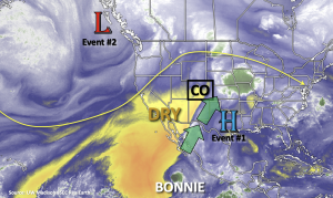
Looking at the water vapor imagery below, there are two very distinctive air masses over the state with more moisture located along and to the east of the green arrows. Dry southwesterly flow is forecast to increase through tomorrow, and paired with a building High pressure axis to our west and north, hot temperatures and minimal rainfall are forecast for this weekend (Event #1). Just how hot will it get? Guidance is showing high temperatures as high as 15-18°F above normal, so there could be some daily temperature records broken. Afternoon high temperatures across the eastern plains and western valleys could reach between 100-105°F, so expect to see some excessive heat advisories to be issued.
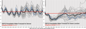
The Low shown off the west coast is forecast to slowly break down the ridge by late this weekend and into early next week. This will allow the trough to pass to our north and return cooler temperatures to start the work week behind a cold front. Higher moisture return is expected over eastern Colorado as shown by normal to below average values in the PW plumes below, which will cause an Elevated flood threat to be issued for the start of Event #2. Moisture return over western Colorado is less certain, but there will likely be an uptick in storm coverage over the southern high terrains during this period.
The ridge axis will then begin to rebuild to our west before moving directly overhead by mid-next week, which will place Colorado in an unfavorable position for moisture transport. This should cause a downtick in afternoon storm coverage as well as flooding potential, which is shown by a slight decrease in the average PW plume over Denver below.
Event #3 likely begins at the end of next week as another Low moves off the west coast and pushes the ridge axis to our east. This is typically a favorable pattern for moisture return, therefore an Elevated flood threat has been issued.
Event #1: Friday – Sunday (7/8 – 7/10)
No Apparent Threat as subsidence and drying keeps only isolated precipitation chances in the forecast.
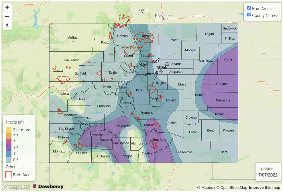
As is typical during monsoon season, residual moisture often gets trapped underneath the ridging pattern. While drying trends occur between systems, there is typically enough residual moisture to produce at least weak rainfall over the mountains with our diurnal heating pattern. That is exactly what will happen this weekend, which means that a few lucky spots (likely south) will get a small break from the heat. However, with the dry surface layer, virga and cloud cover will be more likely along with brief outflow winds from storms that develop. Max 30-minute rainfall rates around 0.40 inches look to be possible, so flooding is NOT expected. Due to the more isolated nature of the rainfall this weekend and totals likely remaining under 0.5 inches, no precipitation map has been drawn.
Event #2: Monday – Thursday (7/11 – 7/14)
Elevated/No Apparent Threat flood threat as the ridge breaks down and a cold front returns moisture to eastern and central Colorado.
A cold front looks to drop south across the state sometime from late on Sunday into Monday, which should help return cooler temperatures behind it. It looks to stall out before making it fully across the state, so southern Colorado is forecast to remain hot. Moisture return looks decent over eastern and central Colorado, which means there will be an increased chance for precipitation in the afternoon and evenings. The transition to westerly and northwest flow aloft is also favorable for sending mid-level disturbances through the state, and with storms tracking to the adjacent eastern plains where moisture is higher, there will be an Elevated flood threat. Daily details will be tracked in the FTB, but it is likely the flood threat will only affect the adjacent eastern plains. More run of the mill rainfall and thunderstorms are forecast for the latter part of this event favoring the high terrains for accumulation.
Event #3: Friday – Tuesday (7/15 – 7/19)
Elevated/No Apparent Threat as subtropical moisture returns to the state.
Still a bit too far out to know all the details about Event #3, but there is consensus among guidance that the upper-level ridge axis will be pushed slightly eastward during this period. This is a favorable pattern for moisture advection across the state, so it is likely scattered to numerous storms will return to the forecast for the weekend. Slowing steering flow under the ridge should allow storms to produce higher accumulations, so an Elevated flood threat has been issued. Tune back into the FTO on Monday as the details of this event will likely evolve. Due to low confidence in the placement of precipitation this far out, no map has been drawn, but rainfall will likely favor the climatological hotspots: southern San Juan Mountains, Southeast Mountains, Raton Ridge & Palmer Ridge/southern Front Range intersect.


