Issue Date: Monday, June 27th, 2022
Issue Time: 2:15PM MDT
Valid Dates: 6/28-7/12
Anticipating the start of monsoon season is a difficult task, and this year provides an excellent example of why this is the case. According to the American Meteorological Society glossary, the English word “monsoon” is derived from the Arabic word “mausim”, which simply means “season”. It has conventionally been used to describe the seasonal shift in low-level winds in relatively low-latitude places like India where summer heating of the continental air leads to a lowering of pressure compared to that over the nearby ocean. In turn, a transition to onshore winds marks the start of a prolonged rainy season. It is trickier to identify the monsoon over the southwest United States both due to the importance of our topography in driving its own circulation, as well as the fact that at our latitude, we still see synoptic scale disturbances that can promote moisture surges, and ensuing rainfall. Note that synoptic scale forcing is technically NOT part of a conventional monsoon, hence the complication.
The multi-day precipitation event in Colorado from June 17-20 initially looked more like a possibly “one-off” plume of subtropical moisture driven northward by a strong, large-scale trough. Fast forwarding to now, however, it does indeed appear that when it’s all said and done, this event will mark the start of the 2022 Southwest Monsoon.
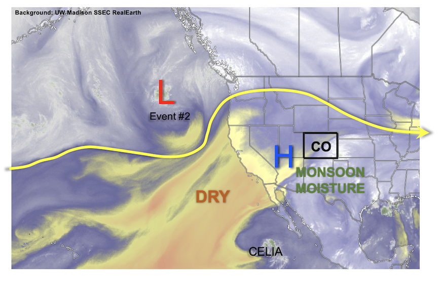
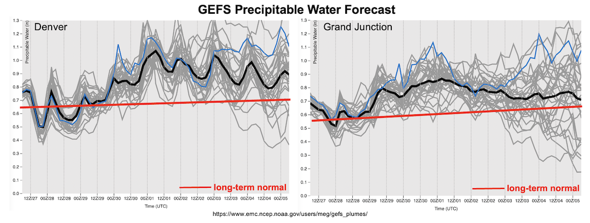
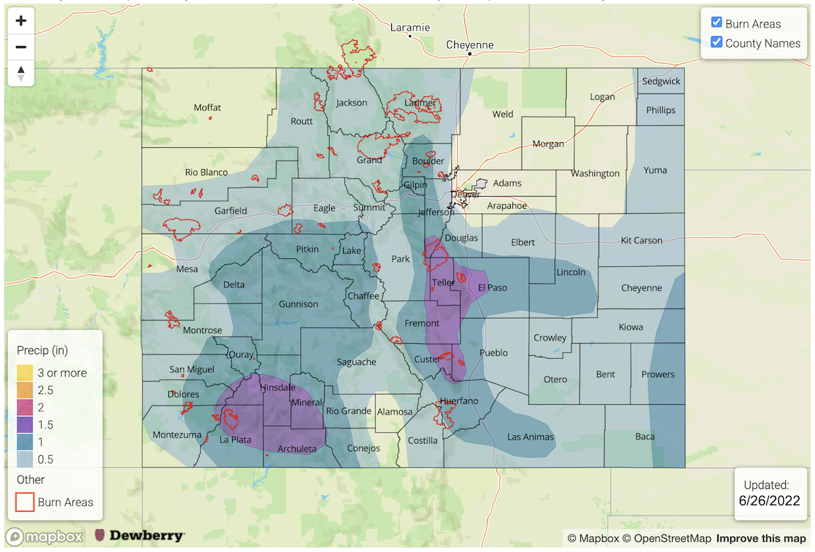
Without meaningful dynamics over the past week, plenty of moisture along with subtle atmospheric disturbances and Colorado’s unique topographically-driven circulation have combined to produce and impressive and widespread 3-5 inches of rainfall over a 10 day period along the New Mexico border. As shown in the water vapor image, below, an upper-level ridge is currently establishing itself over the Four Corners region. This feature will be the primary weather factor in the pattern through the Independence Day weekend. Upper-level ridges are not exactly known as being threatening features from the standpoint of heavy rainfall potential. However, as shown in the forecast PW plumes, below, after a brief drying period through Wednesday, moisture will quickly return and stay well above seasonal normal levels, generally in the 0.7 – 1.2 inch, statewide. With the weak steering flow underneath the ridge, sufficient instability will generate the potential for at least short-term heavy rainfall. Unfortunately, the weak steering flow also reduces our ability to forecast the subtle day-to-day features that could accentuate or mitigate storm coverage and exact intensity. Nonetheless, at a minimum, we expect daily rounds of higher elevation storms through at least the middle of next week.
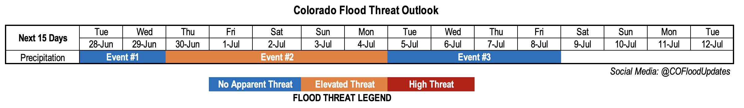
There are three identified precipitation events in this Outlook, and they are described in more detail below.
Event #1: Tuesday – Wednesday (June 28 – June 29)
Scattered Showers and Storms Over Higher Terrain, But No Apparent Flood Threat
The drop in moisture will reduce storm coverage and maximum rainfall intensity over the next 48 hours. However, isolated to widely scattered afternoon showers and thunderstorms are expected first over mainly the San Juan Mountains on Tuesday, then spreading northward into the Central and Northern Mountains by Wednesday. Maximum rainfall intensity is expected to be right around 0.5 inches at any given location. However, that 0.5 inches could fall in a 15-30 minute period as a brief heavy downpour. There is No Apparent Flood threat at this time. However, stay tuned to daily Bulletin updates for the most updated information.
Event #2: Thursday – Monday (June 30 – July 4)
Elevated Flood Threat As An Increase In Storm Coverage And Rainfall Intensity Expected Statewide
The approach of a decaying Pacific cool front will support an increase in shower and storm activity across most of the state heading into the extended Independence Day weekend. By Thursday, storm coverage is expected to be highest over central and northeast Colorado. Friday and Saturday, storms will shift generally south and then southwest into the Southeast Plains, Southeast Mountains and San Juan Mountains. By Sunday and Monday, the highest storm chances will remain over the higher terrain.
Over this prolonged period, daily rainfall intensity exceeding 0.8 inch in 30 minutes and 1.0 inch per hour over at least isolated parts of western and central Colorado looks like a good bet. Further east, storm coverage will be more conditional, and lower in coverage, but higher rainfall intensity approaching 2.0 inches per hour will be possible where storms are able to break through the atmospheric cap.
Overall, this does not look like a particularly threatening event. However, given the fact that there will be an increase in recreational activity over the holiday weekend, please stay tuned to the latest Bulletin updates as heavy rainfall potential will certainly exist.
Event #3: Tuesday – Friday (July 5 – July 8)
A Decrease In Storm Coverage But Precipitation Chances To Continue; No Apparent Flood Threat
Uncertainty in the forecast details increase after Event #2, but it does appear there will be sufficient moisture to support at least isolated thunderstorm activity. The most favorable regions currently appear to be the entire higher terrain. It is too premature to produce a precipitation map for this event, but expect the next Outlook to provide more information.