Issue Date: Monday, July 4th, 2022
Issue Time: 1:30PM MDT
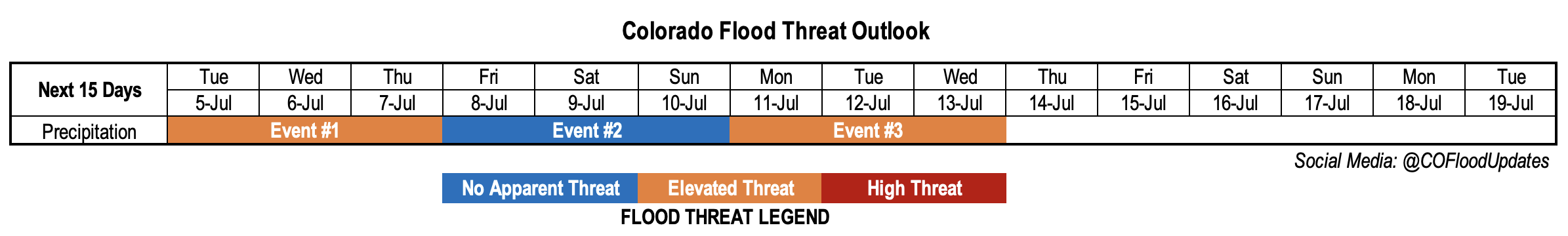
Valid Dates: 7/5 – 7/18
Since last Thursday’s Outlook, there have been a couple of notable forecast changes for this Independence Day edition of the Outlook. First, the aforementioned statewide heat wave is still expected later this week, although its peak intensity and duration have (fortunately!) both trended in the less impressive direction. Second, the anticipated drying is also still on schedule, but it will be limited to mainly the northwest portion of the state and for a shorter duration, essentially leaving the rest of the state vulnerable to at least an isolated heavy rainfall threat for a prolonged stretch.
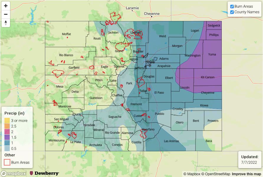
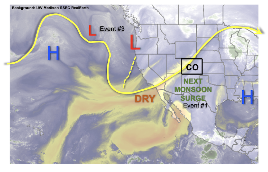
As shown in the water vapor image, below, the features dictating Colorado’s precipitation chances over the course of this Outlook are familiar ones during our summers. First, we note an upper-level ridge centered over the southeast US, which will promote moist, generally southerly flow over Colorado. This will be amplified by a rather strong trough just off the western North American coast. However, the trough itself will move little and actually retrogress (or move “against” the prevailing wind direction) back westward until early next week. Looking closer to home, a pulse of monsoonal moisture is aimed directly at Colorado setting up a 48-72 hour period of enhanced precipitation chances (Event #1). With PW values exceeding 1.5 inches entering AZ and NM, moisture will be once again aplenty over Colorado by Tuesday. Initially, it seemed that only the higher terrain will be the prime recipient of heavier rainfall and elevated flood threat. However, “spillover” moisture now seems like it will make it far enough eastward to bump up heavy rainfall potential over the Northeast Plains (and possibly Southeast Plains).
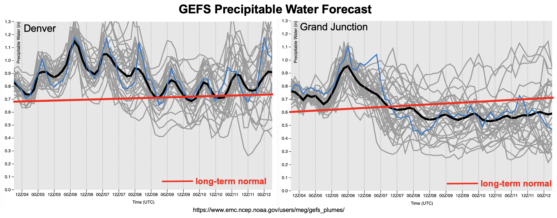
As shown in the forecast GEFS PW plumes, below, moisture will decrease statewide following Event #1, but especially over the northwest part of the state. Precipitation chances will follow suit, though isolated to widely scattered storms are still expected over mainly the central and southern higher terrain (Event #2). Flooding looks unlikely at this time, though given enough moisture, a low-end flood threat could emerge at relatively short notice (i.e. check in with daily Bulletins!). At the same time, the aforementioned upper-level ridge will expand quickly westward and build in strength to produce very hot temperatures for a 24-48 hour stretch next weekend. Fortunately, it does appear that the hot weather will be rather quickly extinguished as a passing of a Pacific cool front looks more likely either late this weekend or early next week. This will setup an increase in precipitation chances as well as heavy rainfall and elevated flooding potential (Event #3). Fortunately, it appears that almost all of eastern Colorado, which has stayed on the drier side during June, should see enhanced coverage of soaking rain. The finer details of Event #3 will still be determined over the next few days, but it suffices to say that no one will be complaining about the heat wave coming to an end so soon.
The identified precipitation events are described in more detail below.
Event #1: Tuesday – Thursday (July 5 – July 7)
Elevated Flood Threat Initially Over Southern/Central High Terrain, Possibly Spreading Over Plains
Widespread showers and thunderstorms are expected over mainly the San Juan and Central Mountains on Tuesday, and then expanding to the Northern Mountains by Wednesday and possibly Thursday. At least isolated short-term heavy rainfall looks likely, with max 30-minute intensity in the 0.8 – 1.0 inch and max 1-hour rainfall in the 1.2 – 1.6 inch range possible. Depending on subtler details such as how quickly the initial round of storms form, there could be a more prolonged 3 – 6 hour rainfall accumulation flood threat elevating the threat of debris slides and mud flows (in addition to flash flooding).
Further east, there is more uncertainty but isolated storms are looking more likely with the potential for marginally heavy rainfall up to 2 inches per hour. An isolated flash flood threat will exist if this materializes.
Event #2: Friday – Sunday (July 8 – July 10)
Storm Coverage And Intensity To Decrease As Heat Builds; No Apparent Flood Threat
Storm coverage and intensity should drop into the isolated to widely scattered variety as heat and subsidence temporarily dominated headlines. The best coverage will be where climatological terrain-induced circulations are most favorable: the Front Range, Central Mountains, San Juan Mountains and Southeast Mountains. Max 30-minute rainfall up to 0.5 inches looks possible, but flooding is currently not anticipated.
Event #3: Monday – Wednesday (July 11 – July 13)
Elevated Flood Threat Returns Mainly To Eastern/Central Colorado
A Pacific cool front is poised to move across northern and eastern Colorado sometime in the Sunday – Monday timeframe, which will set the stage for an increase in moisture, and more favorable dynamics for storm activity. Scattered to numerous showers and storms are expected over the Front Range, Palmer Ridge and Southeast Mountains with max 30-minute rainfall rates looking to exceed 0.8 inches per hour, warranting an elevated threat. Further east across the lower elevations, the character of the rainfall is more uncertain and will depend on instability, front passage timing and moisture. However, with frontal boundaries in place and an increase in PW into the 1.2+ inch range, max 1-hour rainfall exceeding 2.0 inches looks possible at this time, which also warrants a low-end Elevated threat for isolated flash flooding.