FTO 08-25-2016: Two Big Pattern Swings Ahead

Issue Date: 8/25/2016
Issue Time: 2:35 PM

Threat_Timeline_20160825
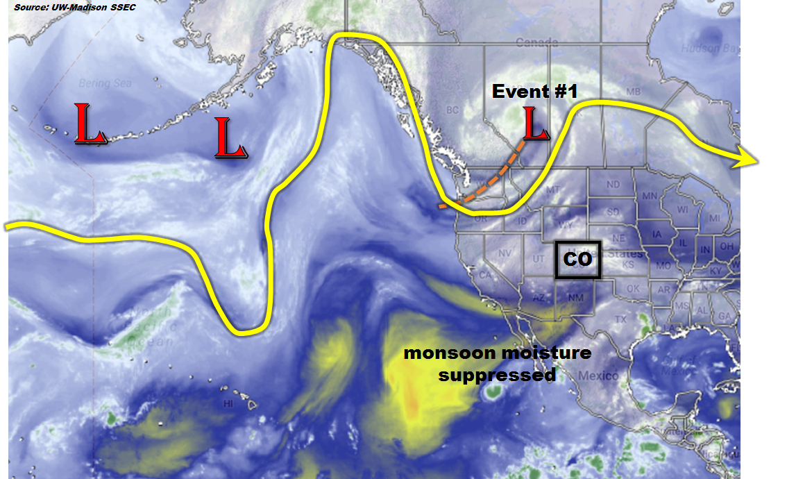
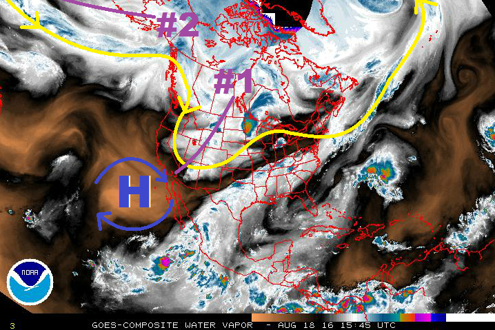
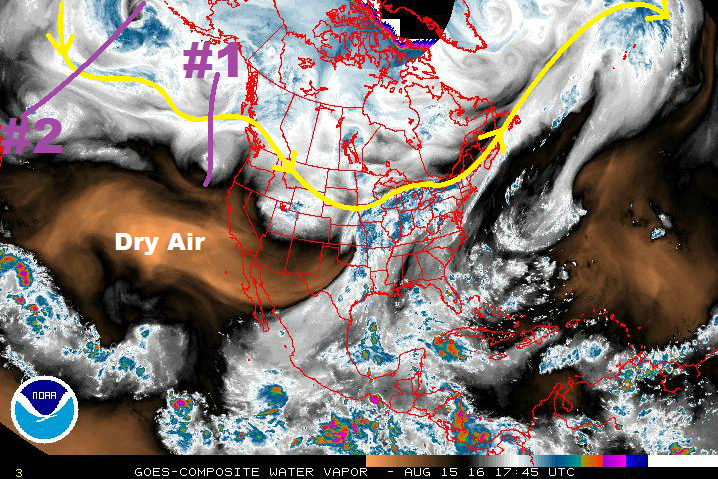
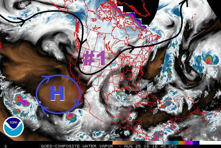
Event #1 in this forecast is a continuation of Event #1 from Monday’s FTO; the event is winding down as the large-scale trough continues its push to the east. Before it is able to clear the state, however, it will provide a couple more days of cooler weather (Friday/Saturday). For Friday, a fair amount of subtropical moisture will still be in place across the state, while the upper-level pattern will promote a good bit of upward motion. Over the mountains, garden variety showers/thunderstorms are expected, with locally heavy rainfall a concern with precipitable water values still elevated. Recent fire burns, like the Hayden Pass Fire burn, will need to be monitored closely. Further east over the lower elevations, a few strong-to-marginally severe thunderstorms will mix in with scattered showers/thunderstorms. The main focus areas for these storms will depend on which area receives the best sunshine and daytime heating, allowing for enhanced instability. Storm motions will help to mitigate the flash flood threat somewhat as they should move fairly quickly to the east.

Activity will begin to wind down on Saturday, so to speak, as upper-level dynamics become less favorable and moisture begins to fade. Residual low-level moisture will keep isolated-to-scattered showers/thunderstorms in the forecast, but reduce the overall flash flood threat. The best chance for heavy rainfall on Saturday will likely be across southern Colorado, where the best moisture will reside. By Sunday, drier air will invade the state as upper-level ridging builds in from the west, ushering in a drier/warmer period.

WV_20160825

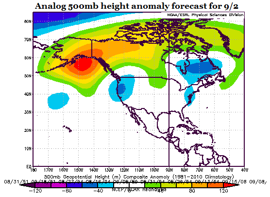
During this period, there will only be limited storm activity, mainly confined to the higher terrain as orographic effects work on residual moisture. Temperatures are expected to climb above seasonal averages, while slightly enhanced fire danger returns over the higher elevations due to low relative humidity. This stretch of warm/dry weather will continue until Thursday, when the next pattern change begins to take shape. A large-scale trough will once again develop/deepen along the west coast, bringing southwesterly flow back to Colorado. This setup would imply rainfall chances for the High Country and Western Slope, with a few storms working across the adjacent lower elevations. Uncertainty regarding smaller-scale features, as well as the amount of monsoonal moisture that will make a return, will keep this event designated as “No Apparent Flood Threat” for the time being. If deep southerly develops in concert with the trough, then the heavy rainfall threat will increase. Stay tuned to Monday’s FTO for an update on this event.

Event #1: Friday (08-26-2016) and Saturday (08-27-2016)

Elevated Flood Threat due to Potential for Locally Heavy Rainfall and Strong Storms

A fair amount of subtropical moisture will still be in place across Colorado on Friday, while the upper-levels provide support for scattered showers/thunderstorms. Pockets of enhanced instability will develop over the plains where the best daytime heating takes place. Over the mountains, scattered garden variety thunderstorms are expected, with locally heavy rainfall remaining a threat. Burn scars, especially new burn scars, will need to be monitored, as well as urban areas with high amounts of impervious surfaces. A couple strong-to-marginally severe thunderstorms will mix in over the plains. Storm motions will help mitigate the flood threat somewhat. For Saturday, moisture and favorable dynamics will begin to fade as the trough continues to shift eastward. Stay tuned to the daily FTB for up-to-date information.

Legend

Event #2: Friday (09-02-2016) through Thursday (09-08-2016)

No Flood Threat Apparent as Moisture Return Isn’t Clear

The stretch of warm/dry weather will come to an end as southwesterly flow aloft returns to the state ahead of the next upper-level trough. Early in the period, the focus for showers/storms will be across the High Country and Western Slope, mainly along and west of the Continental Divide. Uncertainty remains regarding smaller-scale features and moisture return, so expect the precipitation map to change a bit over time as details become clearer.

Legend

FTO 08-22-2016: Early Rainfall Chances Followed By Heat Next Week

Issue Date: Monday, August 22nd, 2016
Issue Time: 2:25PM MDT
Valid dates: August 23rd through September 6th

threat_timeline

A roller-coaster type weather pattern appears to be on the horizon for the Rocky Mountain states including Colorado. The water vapor image, below, shows the path of the polar jet stream across the eastern North Pacific Ocean and western North America. The first important feature is the strong low-pressure system and associated trough centered in western Canada. Upon close inspection, this trough extends across the entire western US coast and is further being supported by a subtropical jet spanning across the southern US and westward into the eastern subtropical Pacific. Interestingly, the generally zonal position of this jet is precluding the northward transport of fresh monsoonal moisture. However, with adequate residual moisture available and sloshing around over CO, UT, NM and AZ, daily thunderstorm and shower activity will be likely across the western slope. This will be further accentuated by the main trough’s movement to the east, which will support the eastward expansion of rain and storm activity across the Continental Divide. The trough will trek only slowly, possibly splitting into multiple centers of action, which may result in an additional quick hitting rainfall chance on Sunday, 8/28.

wv_markup

Upon the trough’s passage, Colorado will enter a generally quieter period of warm/hot weather with only limited storm activity that will last most of next week. Temperatures above seasonal averages will be likely with highs in the 90s for many valley locations. An enhanced wildfire risk is anticipated for a few days especially at higher elevation locations due to low surface relative humidity. However, it does not appear that this stretch of hot weather will last long. A potentially major pattern changes appears possible by early September with a large-scale trough re-developing over the western US coast. This can be seen in today’s analog forecast for 500mb height anomalies centered on September 2nd. These negative height anomalies using the analogs are consistent with long-range atmospheric models, the latter being even more bullish on the trough’s development. This type of flow would imply rainfall chances for the western slope, possibly spreading eastward across the Divide. However, the main wildcard at the moment is the degree to which subtropical monsoonal flow will be involved. Without deep southerly flow, chances of heavy rainfall will be limited and thus this event, #3, is labeled as No Apparent Flood Threat.

analog_8-14dayBelow we describe the details of each event.

Event #1: Tuesday (8/23) through Friday (8/26)

An Elevated Flood Threat will start on the western slope and transition to eastern CO

Tuesday will feature more widespread shower and storm activity for most of the western slope. Climatologically favored regions such as the San Juan, Elk and Sawatch ranges will be most favored for consistently moderate to heavy rainfall from afternoon and evening storms. By Wednesday, the center of action of the heaviest rain will shift both eastward and southward. The Front Range and Palmer Ridge will see an increase in rainfall chances, along with the Sangre de Cristo mountains. However, rainfall amounts do not appear to be particularly threatening. By Thursday and Friday, the most likely scenario is for a continual eastward shift in activity so that the eastern Plains will see a round or two of thunderstorms. Friday the activity will likely be more focused in the Southeast Plains, and a Pacific-origin frontal passage is expected farther north. In all, this multi-day event will bring up to 2 inches of rainfall for isolated locations of the western slope. Farther east 0.5 – 1.0 inch of rainfall will be possible. An isolated flash flood risk will be likely each day, though widespread flooding is not expected.

Legend

Event #2: Sunday (8/28)

A quick hitting rainfall event possible, but No Apparent Flood Threat

The main trough responsible for Event #1 may split with a piece lagging behind and crossing CO on Sunday. At this time, it appears that this will be a very quick hitting event that will likely graze the Northeast Plains with up to 0.5 inches of rainfall. Thus, a rainfall map is not included.

Event #3: Monday (9/5) – Tuesday (9/6)

Significant pattern change possible but No Apparent Flood Threat due to uncertainty about intensity

After a prolonged hot period, a large trough may return to the west coast and bring with it much cooler weather along with an increase in widespread rainfall. As mentioned previously, the return of monsoonal flow is a major wildcard. Without it, this will be a light to moderate rainfall event without a flood threat. With monsoonal flow, this would certainly pose a flood threat. Currently, odds are favoring on limited to negligible monsoon moisture. Thus, we are leaving this event without a flood threat.

FTO 08-18-2016: Two Elevated Flood Threat Events in Next 7 Days

Issue Date: 8/18/2016
Issue Time: 1:24 PM

Threat_Timeline_20160818

The upper-level trough associated with Event #1 (purple line in water vapor image) has begun its push eastward across the northern Rockies. At this time, it appears the trough will slide further north than originally anticipated in Monday’s FTO, which will keep the best broad-scale support north of Colorado. This will help mitigate the threat of heavy rain/flooding somewhat, but a few other factors remain to be considered.

First, the trough will push a cool front south-southeastward through the state on Friday, which will provide upslope flow and an increase in low-level moisture across eastern Colorado. Precipitable water values will tick upward towards, and slightly above, 1 inch along the Urban Corridor and across the plains, which is sufficient for efficient rainfall processes.

Second, Cloud cover and cool temperatures will need to be monitored over the plains, because too much of each and instability will be limited to the low end of the scale, mitigating some of the flood threat. Overall, for Friday, isolated-to-scattered coverage of showers/thunderstorms is expected for the High Country, with more scattered coverage across the lower elevations of eastern Colorado. It will be important to check back in with the FTB for an updated look at the forecast. The airmass will gradually dry out beginning on Saturday, but northwest flow aloft will keep isolated-to-scattered showers/thunderstorms in the forecast over/near the higher terrain, with the steering flow taking a few over the plains.

WV_20160818

After Event #1, a quick reset of upper-level ridging will occur over the state on Sunday/early Monday. Isolated thunderstorms can still be expected over/near the higher terrain thanks to orographic effects and residual moisture, but the overall flooding/heavy rain threat will be reduced. Deeper moisture and southwest flow aloft works back into the region during the afternoon on Monday, marking the start of Event #2. The associated upper-trough will pass through the region on Tuesday night, meaning the best storm coverage during this event will occur on Tuesday. IPW values will not be overly high, with Grand Junction likely topping out near 0.9 inches, so any flood threats over the higher terrain associated with this event will likely be on the low end. The high pressure circulation off the coast of Baja California will continue to help keep deep southwest moisture at bay while the upper-trough again shears moisture to the east of Colorado.

A possible cool front passing through eastern Colorado, associated with the upper-trough, will need to be monitored. Behind it, better moisture and upslope flow will help focus the heavy rain threat along the Front Range/Southeast Mountains and adjacent lower elevations for Wednesday/Thursday. Stay tuned to Monday’s edition of the FTO for an updated look at this time frame.

After Event #2, model solutions diverge, but ensemble solutions suggest a return to upper-level ridging and relatively drier weather through the end of this FTO period. The higher terrain will be favored for daily, diurnally-driven, “garden variety” showers/thunderstorms, while adjacent elevations remain at the mercy of activity drifting off the mountains. Unfortunately, model performance continues to be poor in the extended time frame, so this outcome will need more monitoring.

Event #1: Friday (08-19-2016) and Saturday (08-20-2016)

Elevated Flood Threat as Upper-Level Trough and Cool Front Push Through

A few complicated factors make this near-term event more “muddy” than we’d like, as multiple scenarios must be considered. Above, these factors are discussed in depth:

– Broad-scale support will be positioned further north than previous forecasts indicated
– Cool frontal passage and upslope flow
– Cloud cover limiting daytime heating/instability

Overall, for Friday, isolated-to-scattered coverage of showers/thunderstorms is expected for the High Country, with more scattered coverage across the lower elevations of eastern Colorado. The airmass will gradually dry out beginning on Saturday, but northwest flow aloft will keep isolated-to-scattered showers/thunderstorms in the forecast over/near the higher terrain, with the steering flow taking a few over the plains.

Legend

Event #2: Monday (08-22-2016) through Thursday (08-25-2016)

Elevated Flood Threat as the Next Trough Comes Down the Pipe

Deeper moisture and southwest flow aloft works back into the region during the afternoon on Monday, with the upper-trough passing through on Tuesday night. The best storm coverage during this event will occur on Tuesday with the help of the broad-scale support from the trough. Moisture will increase, but not substantially, with Grand Junction likely topping out near 0.9 inches, so any flood threats over the higher terrain associated with this event will likely be on the low end.

A possible cool front passing through eastern Colorado, will need to be monitored for an increase I moisture and upslope flow. This will help focus the heavy rain threat along the Front Range/Southeast Mountains and adjacent lower elevations for Wednesday/Thursday. Stay tuned to Monday’s edition of the FTO for an updated look.

Legend

FTO 08-15-2016: Elevated Flood Threat This Weekend

Issue Date: 8/15/2016
Issue Time: 2:08 PM

Threat_Timeline_20160815

Prior to Event #1, upper-level troughing will continue the process of deepening over the West Coast. This will bring southwest flow aloft back to Colorado, allowing for a slight uptick in moisture. Embedded in this flow will be a few weak disturbances, resulting in increasing clouds and storm coverage, especially over/near the higher terrain. Drier low-levels will keep rain rates below flash flood thresholds, with the main impacts being gusty winds and lightning. All of this will set the stage for Event #1.

The circulation underneath the purple “#1” on the water vapor image below will drop southward out of Canada, helping to deepen the upper-level trough along the west coast, and begin its transition eastward across the region. This will push a series of cool fronts across Colorado, establish upslope flow in their wake, and reintroducing good low-level moisture. Areas over and near the mountains/preferred terrain of the Raton Ridge/Palmer Ridge will be favored for more widespread showers and thunderstorms, while scattered coverage is expected over the plains. The airmass will gradually dry out beginning on Sunday, but northwest flow aloft will keep isolated-to-scattered showers/thunderstorms in the forecast over/near the higher terrain, with the steering flow taking a few over the plains.

WV_20160815

Event #2 looks to be a quick-hitting event, with a fairly transient mid-/upper-level disturbance being ejected by the longwave trough marked by the purple line/”#2” in the water vapor image. In the mid- and upper-levels, moisture will be fairly lacking across Colorado, but southerly surface flow across the far eastern plains will provide a pool of good low-level moisture. A dry-line/convergence boundary will exist on the western edge of the moisture thanks to westerly flow off of the mountains, providing a focus for a few stronger storms to develop. Drier air over the mountains will attempt to squash convection, but a few isolated thunderstorms will develop, resulting in mainly gusty winds and lightning. Unfortunately, model performance continues to be poor in the extended time frame, so this situation will need more monitoring before a flood threat designation will be given. For now, it will remain “No Apparent Flood Threat.”

Event #1: Friday (08-19-2016) and Sunday (08-21-2016)

Elevated Flood Threat due to Upslope Flow and Deeper Moisture

A low pressure circulation will drop southward out of Canada, helping to deepen the upper-level trough along the west coast. Shortly thereafter, the trough will begin to swing eastward across the region, pushing a series of cool fronts through Colorado. Behind the cool fronts, upslope flow will reintroduce good low-level moisture. Areas over and near the mountains/preferred terrain of the Raton Ridge/Palmer Ridge will be favored for more widespread showers and thunderstorms, while scattered coverage is expected over the plains.

Legend

Event #2: Wednesday (08-24-2016) and Thursday (08-25-2016)

No Apparent Flood Threat as Uncertainty Remains in the Details

Event #2 will be brought on by a fairly transient mid-/upper-level disturbance providing broader scale support to a low-level moisture pool across far eastern Colorado. A few strong-to-severe storms will be possible due to the available moisture, instability, and wind shear. Drier air will be in place over the mountains, so any storms there will result in more wind than rain. As stated above, model performance continues to be poor in the extended time frame, but the QPF map below represents our best forecast thinking. Stay tuned to the next FTO on Thursday for an updated look.

Legend