Issue Date: 8/25/2016
Issue Time: 2:35 PM
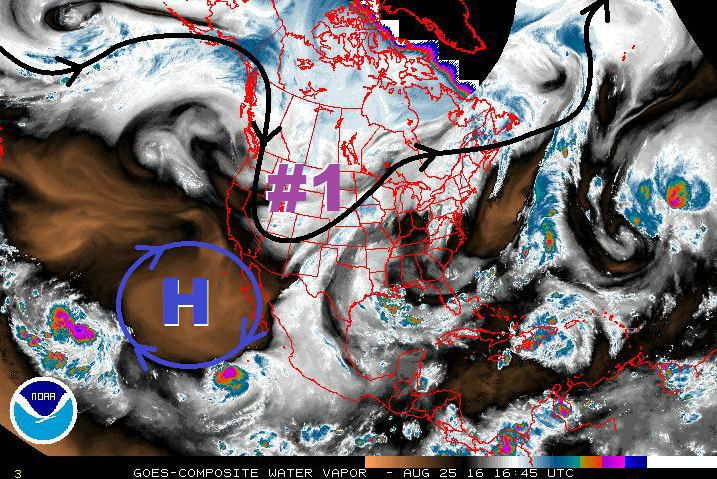
 Event #1 in this forecast is a continuation of Event #1 from Monday’s FTO; the event is winding down as the large-scale trough continues its push to the east. Before it is able to clear the state, however, it will provide a couple more days of cooler weather (Friday/Saturday). For Friday, a fair amount of subtropical moisture will still be in place across the state, while the upper-level pattern will promote a good bit of upward motion. Over the mountains, garden variety showers/thunderstorms are expected, with locally heavy rainfall a concern with precipitable water values still elevated. Recent fire burns, like the Hayden Pass Fire burn, will need to be monitored closely. Further east over the lower elevations, a few strong-to-marginally severe thunderstorms will mix in with scattered showers/thunderstorms. The main focus areas for these storms will depend on which area receives the best sunshine and daytime heating, allowing for enhanced instability. Storm motions will help to mitigate the flash flood threat somewhat as they should move fairly quickly to the east.
Activity will begin to wind down on Saturday, so to speak, as upper-level dynamics become less favorable and moisture begins to fade. Residual low-level moisture will keep isolated-to-scattered showers/thunderstorms in the forecast, but reduce the overall flash flood threat. The best chance for heavy rainfall on Saturday will likely be across southern Colorado, where the best moisture will reside. By Sunday, drier air will invade the state as upper-level ridging builds in from the west, ushering in a drier/warmer period.
During this period, there will only be limited storm activity, mainly confined to the higher terrain as orographic effects work on residual moisture. Temperatures are expected to climb above seasonal averages, while slightly enhanced fire danger returns over the higher elevations due to low relative humidity. This stretch of warm/dry weather will continue until Thursday, when the next pattern change begins to take shape. A large-scale trough will once again develop/deepen along the west coast, bringing southwesterly flow back to Colorado. This setup would imply rainfall chances for the High Country and Western Slope, with a few storms working across the adjacent lower elevations. Uncertainty regarding smaller-scale features, as well as the amount of monsoonal moisture that will make a return, will keep this event designated as “No Apparent Flood Threat” for the time being. If deep southerly develops in concert with the trough, then the heavy rainfall threat will increase. Stay tuned to Monday’s FTO for an update on this event.
Event #1: Friday (08-26-2016) and Saturday (08-27-2016)
Elevated Flood Threat due to Potential for Locally Heavy Rainfall and Strong Storms
A fair amount of subtropical moisture will still be in place across Colorado on Friday, while the upper-levels provide support for scattered showers/thunderstorms. Pockets of enhanced instability will develop over the plains where the best daytime heating takes place. Over the mountains, scattered garden variety thunderstorms are expected, with locally heavy rainfall remaining a threat. Burn scars, especially new burn scars, will need to be monitored, as well as urban areas with high amounts of impervious surfaces. A couple strong-to-marginally severe thunderstorms will mix in over the plains. Storm motions will help mitigate the flood threat somewhat. For Saturday, moisture and favorable dynamics will begin to fade as the trough continues to shift eastward. Stay tuned to the daily FTB for up-to-date information.
Event #2: Friday (09-02-2016) through Thursday (09-08-2016)
No Flood Threat Apparent as Moisture Return Isn’t Clear
The stretch of warm/dry weather will come to an end as southwesterly flow aloft returns to the state ahead of the next upper-level trough. Early in the period, the focus for showers/storms will be across the High Country and Western Slope, mainly along and west of the Continental Divide. Uncertainty remains regarding smaller-scale features and moisture return, so expect the precipitation map to change a bit over time as details become clearer.

