Issue Date: Monday, August 22nd, 2016
Issue Time: 2:25PM MDT
Valid dates: August 23rd through September 6th

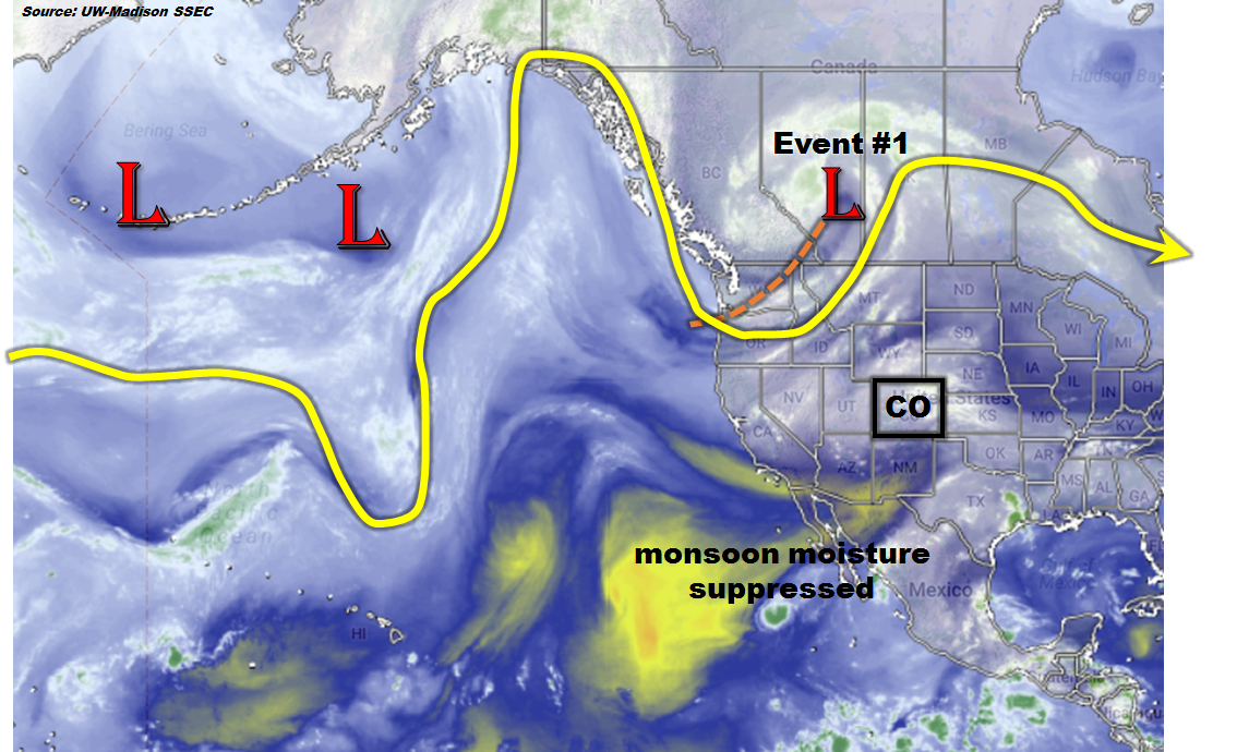
A roller-coaster type weather pattern appears to be on the horizon for the Rocky Mountain states including Colorado. The water vapor image, below, shows the path of the polar jet stream across the eastern North Pacific Ocean and western North America. The first important feature is the strong low-pressure system and associated trough centered in western Canada. Upon close inspection, this trough extends across the entire western US coast and is further being supported by a subtropical jet spanning across the southern US and westward into the eastern subtropical Pacific. Interestingly, the generally zonal position of this jet is precluding the northward transport of fresh monsoonal moisture. However, with adequate residual moisture available and sloshing around over CO, UT, NM and AZ, daily thunderstorm and shower activity will be likely across the western slope. This will be further accentuated by the main trough’s movement to the east, which will support the eastward expansion of rain and storm activity across the Continental Divide. The trough will trek only slowly, possibly splitting into multiple centers of action, which may result in an additional quick hitting rainfall chance on Sunday, 8/28.
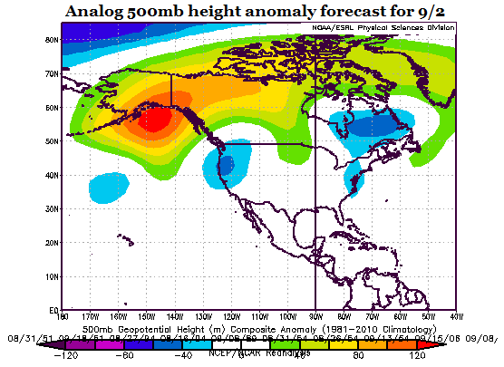
Upon the trough’s passage, Colorado will enter a generally quieter period of warm/hot weather with only limited storm activity that will last most of next week. Temperatures above seasonal averages will be likely with highs in the 90s for many valley locations. An enhanced wildfire risk is anticipated for a few days especially at higher elevation locations due to low surface relative humidity. However, it does not appear that this stretch of hot weather will last long. A potentially major pattern changes appears possible by early September with a large-scale trough re-developing over the western US coast. This can be seen in today’s analog forecast for 500mb height anomalies centered on September 2nd. These negative height anomalies using the analogs are consistent with long-range atmospheric models, the latter being even more bullish on the trough’s development. This type of flow would imply rainfall chances for the western slope, possibly spreading eastward across the Divide. However, the main wildcard at the moment is the degree to which subtropical monsoonal flow will be involved. Without deep southerly flow, chances of heavy rainfall will be limited and thus this event, #3, is labeled as No Apparent Flood Threat.
 Below we describe the details of each event.
Event #1: Tuesday (8/23) through Friday (8/26)
An Elevated Flood Threat will start on the western slope and transition to eastern CO
Tuesday will feature more widespread shower and storm activity for most of the western slope. Climatologically favored regions such as the San Juan, Elk and Sawatch ranges will be most favored for consistently moderate to heavy rainfall from afternoon and evening storms. By Wednesday, the center of action of the heaviest rain will shift both eastward and southward. The Front Range and Palmer Ridge will see an increase in rainfall chances, along with the Sangre de Cristo mountains. However, rainfall amounts do not appear to be particularly threatening. By Thursday and Friday, the most likely scenario is for a continual eastward shift in activity so that the eastern Plains will see a round or two of thunderstorms. Friday the activity will likely be more focused in the Southeast Plains, and a Pacific-origin frontal passage is expected farther north. In all, this multi-day event will bring up to 2 inches of rainfall for isolated locations of the western slope. Farther east 0.5 – 1.0 inch of rainfall will be possible. An isolated flash flood risk will be likely each day, though widespread flooding is not expected.

Event #2: Sunday (8/28)
A quick hitting rainfall event possible, but No Apparent Flood Threat
The main trough responsible for Event #1 may split with a piece lagging behind and crossing CO on Sunday. At this time, it appears that this will be a very quick hitting event that will likely graze the Northeast Plains with up to 0.5 inches of rainfall. Thus, a rainfall map is not included.
Event #3: Monday (9/5) – Tuesday (9/6)
Significant pattern change possible but No Apparent Flood Threat due to uncertainty about intensity
After a prolonged hot period, a large trough may return to the west coast and bring with it much cooler weather along with an increase in widespread rainfall. As mentioned previously, the return of monsoonal flow is a major wildcard. Without it, this will be a light to moderate rainfall event without a flood threat. With monsoonal flow, this would certainly pose a flood threat. Currently, odds are favoring on limited to negligible monsoon moisture. Thus, we are leaving this event without a flood threat.