Issue Date: 8/18/2016
Issue Time: 1:24 PM

The upper-level trough associated with Event #1 (purple line in water vapor image) has begun its push eastward across the northern Rockies. At this time, it appears the trough will slide further north than originally anticipated in Monday’s FTO, which will keep the best broad-scale support north of Colorado. This will help mitigate the threat of heavy rain/flooding somewhat, but a few other factors remain to be considered.
First, the trough will push a cool front south-southeastward through the state on Friday, which will provide upslope flow and an increase in low-level moisture across eastern Colorado. Precipitable water values will tick upward towards, and slightly above, 1 inch along the Urban Corridor and across the plains, which is sufficient for efficient rainfall processes.
Second, Cloud cover and cool temperatures will need to be monitored over the plains, because too much of each and instability will be limited to the low end of the scale, mitigating some of the flood threat. Overall, for Friday, isolated-to-scattered coverage of showers/thunderstorms is expected for the High Country, with more scattered coverage across the lower elevations of eastern Colorado. It will be important to check back in with the FTB for an updated look at the forecast. The airmass will gradually dry out beginning on Saturday, but northwest flow aloft will keep isolated-to-scattered showers/thunderstorms in the forecast over/near the higher terrain, with the steering flow taking a few over the plains.
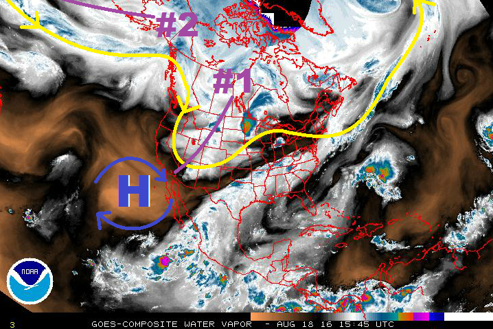
After Event #1, a quick reset of upper-level ridging will occur over the state on Sunday/early Monday. Isolated thunderstorms can still be expected over/near the higher terrain thanks to orographic effects and residual moisture, but the overall flooding/heavy rain threat will be reduced. Deeper moisture and southwest flow aloft works back into the region during the afternoon on Monday, marking the start of Event #2. The associated upper-trough will pass through the region on Tuesday night, meaning the best storm coverage during this event will occur on Tuesday. IPW values will not be overly high, with Grand Junction likely topping out near 0.9 inches, so any flood threats over the higher terrain associated with this event will likely be on the low end. The high pressure circulation off the coast of Baja California will continue to help keep deep southwest moisture at bay while the upper-trough again shears moisture to the east of Colorado.
A possible cool front passing through eastern Colorado, associated with the upper-trough, will need to be monitored. Behind it, better moisture and upslope flow will help focus the heavy rain threat along the Front Range/Southeast Mountains and adjacent lower elevations for Wednesday/Thursday. Stay tuned to Monday’s edition of the FTO for an updated look at this time frame.
After Event #2, model solutions diverge, but ensemble solutions suggest a return to upper-level ridging and relatively drier weather through the end of this FTO period. The higher terrain will be favored for daily, diurnally-driven, “garden variety” showers/thunderstorms, while adjacent elevations remain at the mercy of activity drifting off the mountains. Unfortunately, model performance continues to be poor in the extended time frame, so this outcome will need more monitoring.
Event #1: Friday (08-19-2016) and Saturday (08-20-2016)
Elevated Flood Threat as Upper-Level Trough and Cool Front Push Through
A few complicated factors make this near-term event more “muddy” than we’d like, as multiple scenarios must be considered. Above, these factors are discussed in depth:
– Broad-scale support will be positioned further north than previous forecasts indicated
– Cool frontal passage and upslope flow
– Cloud cover limiting daytime heating/instability
Overall, for Friday, isolated-to-scattered coverage of showers/thunderstorms is expected for the High Country, with more scattered coverage across the lower elevations of eastern Colorado. The airmass will gradually dry out beginning on Saturday, but northwest flow aloft will keep isolated-to-scattered showers/thunderstorms in the forecast over/near the higher terrain, with the steering flow taking a few over the plains.

Event #2: Monday (08-22-2016) through Thursday (08-25-2016)
Elevated Flood Threat as the Next Trough Comes Down the Pipe
Deeper moisture and southwest flow aloft works back into the region during the afternoon on Monday, with the upper-trough passing through on Tuesday night. The best storm coverage during this event will occur on Tuesday with the help of the broad-scale support from the trough. Moisture will increase, but not substantially, with Grand Junction likely topping out near 0.9 inches, so any flood threats over the higher terrain associated with this event will likely be on the low end.
A possible cool front passing through eastern Colorado, will need to be monitored for an increase I moisture and upslope flow. This will help focus the heavy rain threat along the Front Range/Southeast Mountains and adjacent lower elevations for Wednesday/Thursday. Stay tuned to Monday’s edition of the FTO for an updated look.