Issue Date: 8/15/2016
Issue Time: 2:08 PM

Prior to Event #1, upper-level troughing will continue the process of deepening over the West Coast. This will bring southwest flow aloft back to Colorado, allowing for a slight uptick in moisture. Embedded in this flow will be a few weak disturbances, resulting in increasing clouds and storm coverage, especially over/near the higher terrain. Drier low-levels will keep rain rates below flash flood thresholds, with the main impacts being gusty winds and lightning. All of this will set the stage for Event #1.
The circulation underneath the purple “#1” on the water vapor image below will drop southward out of Canada, helping to deepen the upper-level trough along the west coast, and begin its transition eastward across the region. This will push a series of cool fronts across Colorado, establish upslope flow in their wake, and reintroducing good low-level moisture. Areas over and near the mountains/preferred terrain of the Raton Ridge/Palmer Ridge will be favored for more widespread showers and thunderstorms, while scattered coverage is expected over the plains. The airmass will gradually dry out beginning on Sunday, but northwest flow aloft will keep isolated-to-scattered showers/thunderstorms in the forecast over/near the higher terrain, with the steering flow taking a few over the plains.
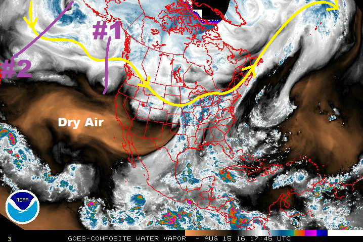
Event #2 looks to be a quick-hitting event, with a fairly transient mid-/upper-level disturbance being ejected by the longwave trough marked by the purple line/”#2” in the water vapor image. In the mid- and upper-levels, moisture will be fairly lacking across Colorado, but southerly surface flow across the far eastern plains will provide a pool of good low-level moisture. A dry-line/convergence boundary will exist on the western edge of the moisture thanks to westerly flow off of the mountains, providing a focus for a few stronger storms to develop. Drier air over the mountains will attempt to squash convection, but a few isolated thunderstorms will develop, resulting in mainly gusty winds and lightning. Unfortunately, model performance continues to be poor in the extended time frame, so this situation will need more monitoring before a flood threat designation will be given. For now, it will remain “No Apparent Flood Threat.”
Event #1: Friday (08-19-2016) and Sunday (08-21-2016)
Elevated Flood Threat due to Upslope Flow and Deeper Moisture
A low pressure circulation will drop southward out of Canada, helping to deepen the upper-level trough along the west coast. Shortly thereafter, the trough will begin to swing eastward across the region, pushing a series of cool fronts through Colorado. Behind the cool fronts, upslope flow will reintroduce good low-level moisture. Areas over and near the mountains/preferred terrain of the Raton Ridge/Palmer Ridge will be favored for more widespread showers and thunderstorms, while scattered coverage is expected over the plains.

Event #2: Wednesday (08-24-2016) and Thursday (08-25-2016)
No Apparent Flood Threat as Uncertainty Remains in the Details
Event #2 will be brought on by a fairly transient mid-/upper-level disturbance providing broader scale support to a low-level moisture pool across far eastern Colorado. A few strong-to-severe storms will be possible due to the available moisture, instability, and wind shear. Drier air will be in place over the mountains, so any storms there will result in more wind than rain. As stated above, model performance continues to be poor in the extended time frame, but the QPF map below represents our best forecast thinking. Stay tuned to the next FTO on Thursday for an updated look.