FTO 05-18-2017: Very Active, Cool Pattern But Flood Threat Subdued

Issue Date: May 18, 2017
Issue Time: 1PM MDT
Valid Dates: May 19th – June 2

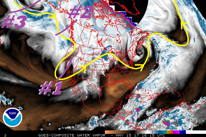
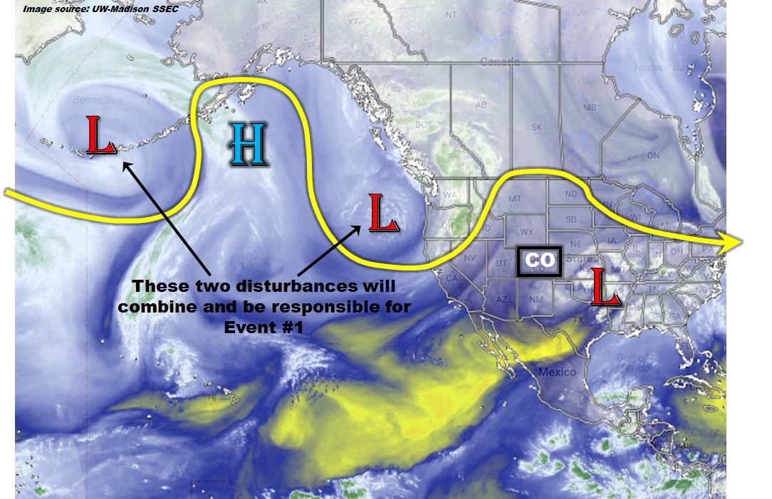
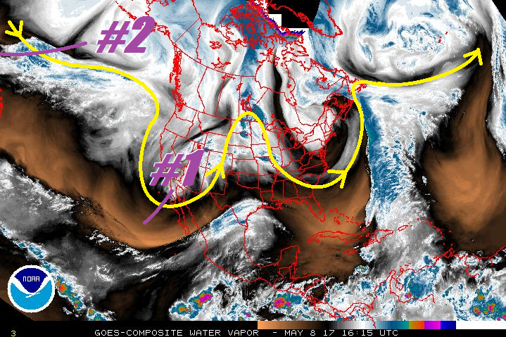
The North Pacific/North American water vapor image, below, shows a very active jet stream across the entire region. During the next 15 days, there are four precipitation events that have been identified as capable of producing widespread precipitation. Event #1 is ongoing, courtesy of a cut-off low that is currently swinging through Colorado, providing a late spring snowstorm for the higher terrain and rain for the lower elevations. Most of the precipitation associated with this storm will be finished by later this evening. However, some additional precipitation will be possible for eastern parts of the state on Friday. Thereafter, the ridge currently off the west coast will shift slightly eastward, intensify and aid in the development of an impressive trough across the central United States. This kind of pattern will promote a slew of disturbances, referred to here as Event #2 and Event #3, originating off the Canadian and Montana Rockies and quickly moving southeastward across eastern Colorado. While precipitation chances with each disturbance are high, no flood threat is currently warranted.

The period from May 27 – May 30 currently looks to be an in-between period where the west coast ridge will temporarily bulge into Colorado. A few warm days are likely during this stretch. Thereafter, a breakdown of the southern periphery of the ridge is expected, which will provide access for disturbances to affect Colorado from the west and southwest. Once again, no flood threat is warranted at this time, and future Outlooks will have a better grasp of this event.

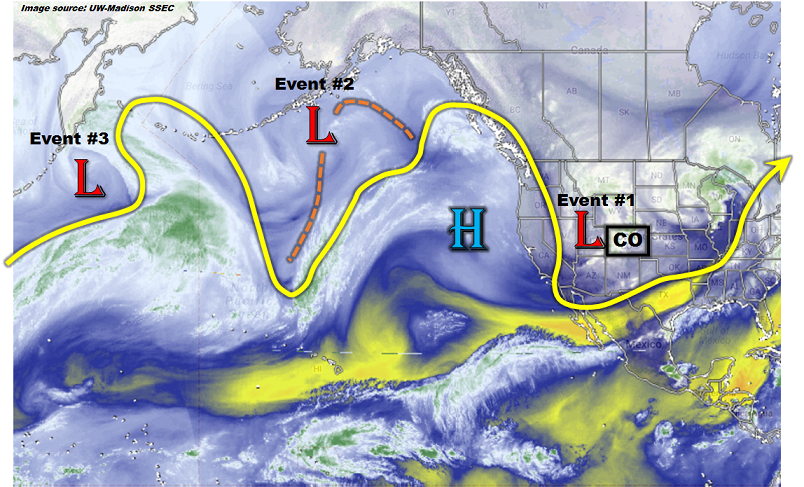
Below we describe each of the three identified Events in more detail.

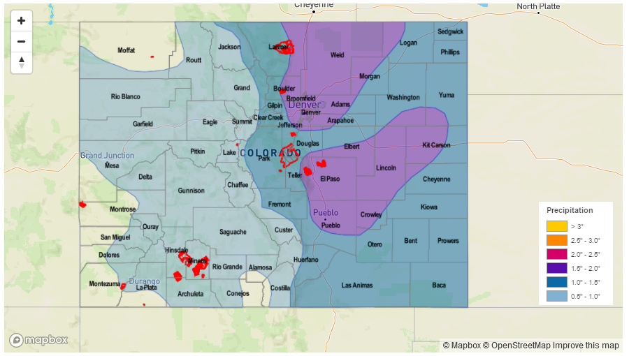
Event #1: Friday (5/19)

Elevated Flood Threat as cut-off low pressure exits the region

An impressive late spring snowstorm will depart Colorado early Friday. As it does so, light to moderate rainfall, possibly mixed with morning snow above 6,000 feet will continue through Friday afternoon. The rainfall intensity will not be enough to cause flooding concerns. However, the large amount of antecedent rainfall will mean that many creeks and streams of the Front Range will be swollen. Some of this will be mitigated by low snow levels, which will greatly temper the runoff rates. Nonetheless, nuisance stream-side flooding will be common in the foothills. This is expected to subside by Saturday. Please pay attention to National Weather Service warnings and advisories for key problem areas.

Legend

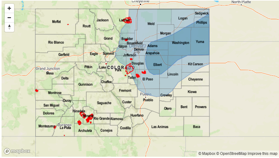
Event #2: Sunday (5/21) through Tuesday (5/23)

Daily precipitation chances but No Anticipated Flood Threat

A large-scale ridge-trough combination will setup by Sunday across western and central North America, respectively. Several “northwest flow” disturbances will quickly trek across mainly eastern Colorado from Sunday through Tuesday. The amount of instability through this time period appears to be low as return (easterly/southeasterly) flow will not have time to develop. Although many areas will see light precipitation, flooding is not expected. Nonetheless, many higher elevation regions east of the Continental Divide should pick up over 0.5 inches of beneficial rain and snowfall during this time period.

Legend

Event #3: Thursday (5/25) through Friday (5/26)

No Anticipated Flood Threat at this time, but upgrade possible

Although the large-scale pattern from Event #2 is expected to continue as Event #3 occurs, there may be more moisture available for heavier precipitation amounts. The favored regions are expected to be northeast Colorado and into the Palmer Ridge. At this time, there is not enough confidence to warrant a precipitation map.

Event #4: Wednesday (5/31) through Friday (6/2)

No Anticipated Flood Threat at this time

After Event #3, a high pressure ridge will bulge eastward causing a string of warm and mainly dry days. Thereafter, reasonable consensus exists that the flow along the southern periphery of the ridge will break down and allow for a return of disturbances from the west and southwest. Such a pattern would be conducive for moderate to heavy rainfall in the San Juans as well as most of eastern Colorado, east of the Continental Divide. At this time, there is not enough confidence that the ridge will break down. Thus, a precipitation map is not provided.

FTO 05-15-2017: Active Period Ahead

Issue Date: 5/15/2017
Issue Time: 1:00 PM

An active period is in store for Colorado over the next ten days with three events lined up to swing through the region. The water vapor image below highlights the three disturbances associated with each: Event #1 is the upper-trough currently over the western US, Event #2 is an upper-level low that will dig in immediately behind #1, and Event #3 is an upper-level trough/low gathering near Alaska. Event #1 is a quick-hitting event, with the upper-trough pushing through the region Tuesday and exiting Tuesday night ahead of the second event. Moisture isn’t expected to be deep enough to warrant widespread flooding concerns, but close attention will be paid during tomorrow’s FTB. Make sure you check back in for that updated information.

Event #2 will present an elevated flood threat to Colorado, thanks in part to its expected slow movement, broad upper-level support, the return of deeper moisture from the subtropics, and surface features including a cold front and upslope flow. At this time, it appears that Wednesday and Thursday will be the days with the greatest flood threat during this event. Event #3, at the moment, is expected to move into the region by Monday of next week, but the flood threat is far from certain. Questions about the depth of moisture and locations of any surface boundaries will need to be answered before a determination can be made. However, using climatology as a tool, one can infer that there will likely be a chance for strong-to-severe thunderstorms across eastern Colorado during a setup such as the one expected, and with that usually comes a flood threat. With that in mind, stay tuned to the update in Thursday’s FTB.

Event #1: Tuesday (05-16-2017)

No Apparent Threat as Stage Gets Set for Following Event

Event #1 is a quick-hitting event, but it will “set the state,” so to speak, for Event #2. Decent lapse rates and ascent will provide the support for scattered showers and thunderstorms across the state. Far eastern Colorado will have a slim chance for a strong-to-severe thunderstorm or two, but it looks like the majority of the state will be under the risk of garden-variety showers/storms. The depth of moisture, at this time, doesn’t appear to be enough to warrant a flood threat. Pay attention to the FTB tomorrow for any updates to the situation. No precipitation map will be drawn due to expected totals below 0.5 inches.

Event #2: Wednesday (05-17-2017) through Friday (05-19-2017)

Elevated Flood Threat as Upper-Level Low Swings Through

A fairly slow-moving upper-level low, combined with intensifying surface low pressure and the presence of a frontal boundary, will set Colorado up for an unsettled 3-day period of showers/thunderstorms. Scattered-to-widespread activity is expected, with swaths of greater than 1 inch of rain expected across portions of the Grand Valley, Central Mountains, San Juan Mountains, Front Range, Southeast Mountains, Urban Corridor, Palmer Ridge, Northeast Plains and Southeast Plains. Stay tuned to daily FTB’s for more information.

Legend

Event #3: Monday (05-22-2017) through Wednesday (05-24-2017)

No Apparent Threat Due to Uncertainty, But Climatology is Important

Uncertainty will keep this period from obtaining any flood threat designation, but climatology points toward the possibility with the upper-level pattern expected. Eastern Colorado will be under the greatest concern for strong-to-severe thunderstorms and heavy rainfall, but the presence of easterly low-level flow could push this back into the mountains and foothills, as well. No precipitation map will be drawn until more details come into focus. Stay tuned.

FTO 05-11-2017: Warm and Dry To Start, Followed By Multi-Day Flood Threat

Issue Date: May 11th, 2017
Issue Time: 3:05PM EDT
Valid Dates: May 12 – May 26

This afternoon’s water vapor imagery, below, continues to show a very active North Pacific jet stream that will continue to affect Colorado over the next 15 days. The first feature of note is the departing cut-off low-pressure system that affected the state over the past 3 days. As this continues to move away, Colorado will be increasingly influenced by a moderate strength ridge that will provide several days of warm and dry conditions. Certainly a welcome change after a string of days with severe weather and heavy rainfall.

Turning our attention westwards, we see two low-pressure systems in the North Pacific, separated by a high pressure ridge. Despite the fact that the eastern feature is already entering the west coast of North America, it will be in no hurry to propagate eastward and will instead nearly stall out. Thereafter, guidance is in surprisingly good agreement that the two large-scale troughs will merge over the western US and thereafter begin to affect Colorado. This has been identified as Event #1. There is some uncertainty as to how long this event will affect the state and where exactly the low pressure will develop. However, an elevated flood threat appears likely.

Thereafter, a more zonal flow will develop over western North America. Seasonally warm temperatures are expected and several weak disturbances may affect the state. However, the next organized precipitation event does not appear to be in the works until the latter part of the 15-day period, when another trough affects Colorado.

Below we describe each of the two identified Events in more detail.

Event #1: Thursday (5/18) and Friday (5/19)

Elevated Flood Threat as another cut-off low pressure is likely to affect Colorado’s weather

Somewhat similar to the recent cut-off low pressure, this event will begin in earnest on Thursday as the cut-off enters the state either from the west or southwest. Current guidance is in very good agreement about the chances of heavy rainfall both Thursday and Friday. On Thursday, as the disturbance first affects the state, at least one round of thunderstorms is expected across a wide swath of the state, with the possible exception of the far southeast. Flash flooding will be possible along with hail, and gusty thunderstorm winds. Up to 1.5 inches of rainfall could fall, with the highest threat regions being the Palmer Ridge and into the Central Mountains. By Friday, as the system moves across the state, a deep easterly/southeasterly moisture feed will likely result in another round of showers and thunderstorms. The focus region this time will be in the Front Range along the Wyoming border. Flash flooding, debris slides and mud flows will be possible. It is possible that this event is upgraded to a High flood threat, so stay tuned.

Legend

Event #2: Thursday (5/25) and Friday (5/26)

No Anticipated Flood Threat at this time

A more zonal flow will provide Colorado with seasonable weather after Event #1. At this time, it appears another large-scale trough may enter the west coast by Wednesday 5/24. Thereafter, chances of widespread precipitation will increase as easterly winds bring in Gulf of Mexico moisture. The chances of rainfall exceeding 0.5 inches is uncertain at this time, so no precipitation map is provided.

FTO 05-08-2017: A Tale of Two, Slow-Moving Troughs

Issue Date: 5/8/2017
Issue Time: 1:10 PM

Two events are highlighted over the next 15 days, brought about by two large-scale low pressure troughs that are slow to leave the region. Both of these troughs/upper-lows are visible in the water vapor imagery below, denoted by the purple “#1” and “#2”. Event #1 is ongoing at this time, as the upper-level low continues to spin across the desert SW/northern California Baja. Due to its placement, along with the central US ridge, southerly flow will continue to direct moisture from the subtropics across Colorado for the next few days. The flood threat is heightened on Tuesday and Wednesday, but will wind down on Thursday. By Friday, the upper-low is expected to be over central Great Plains, with drier, northwesterly flow across Colorado as upper-level ridging builds in. Residual moisture over the mountains will allow for the usual diurnal convection to take place, but no flood threat is expected. The ridge will hold down the flood threat through Saturday, before southerly flow returns on Sunday as the next upper-level low (Event #2) digs southward along the West Coast.

Just as Event #1, the upper-level low associated with Event #2 is expected to be a slow-moving system, providing multiple days of subtropical moisture to the region. There is, however, significant uncertainty in the low’s exact placement, which will have profound implications on the moisture return in Colorado. Right now, it appears that it will be tilted/located in a way that doesn’t maximize rainfall in Colorado, and therefore no flood threat is apparent. This situation can change, and attention will need to be paid to this system. Stay tuned for an update in Thursday’s FTO. After Event #2, ridging is expected to build back across the region, and a bit of a drying trend will take place.

Event #1: Tuesday (05-09-2017) through Thursday (05-11-2017)

Elevated Flood Threat for Exiting Upper-Level Low

The upper-level low will begin its exit from the region, slowly moving across AZ/NM and eventually into central KS/OK. Ahead of the low, southerly flow will continue to advect moisture northward into the region through Wednesday. South-southeasterly surface flow behind Monday’s cold front will open the low-levels to Gulf of Mexico moisture, while the mid- and upper-levels continue to be saturated from the subtropics. As the low moves east of the area by Thursday and the subtropical moisture stream is cut off, residual moisture from the previous days of rainfall will allow for diurnal convection to take place, mainly in/near the mountains.

Event #2: Sunday (05-14-2017) through Thursday (05-18-2017)

No Apparent Threat Due to Uncertainty Surrounding Low’s Placement

The upper-level low associated with Event #2 is apparent, and is forecast to dig southward along the West Coast by Sunday. Uncertainty surrounds its exact placement and the tilt of the system, which can have profound implications on the amount of moisture available to Colorado. Due to the uncertainty, no precipitation map will be drawn. Please check back with Thursday’s FTO for an update to this event.