Issue Date: 5/15/2017
Issue Time: 1:00 PM

An active period is in store for Colorado over the next ten days with three events lined up to swing through the region. The water vapor image below highlights the three disturbances associated with each: Event #1 is the upper-trough currently over the western US, Event #2 is an upper-level low that will dig in immediately behind #1, and Event #3 is an upper-level trough/low gathering near Alaska. Event #1 is a quick-hitting event, with the upper-trough pushing through the region Tuesday and exiting Tuesday night ahead of the second event. Moisture isn’t expected to be deep enough to warrant widespread flooding concerns, but close attention will be paid during tomorrow’s FTB. Make sure you check back in for that updated information.
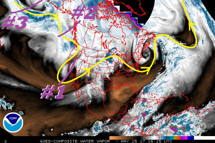
Event #2 will present an elevated flood threat to Colorado, thanks in part to its expected slow movement, broad upper-level support, the return of deeper moisture from the subtropics, and surface features including a cold front and upslope flow. At this time, it appears that Wednesday and Thursday will be the days with the greatest flood threat during this event. Event #3, at the moment, is expected to move into the region by Monday of next week, but the flood threat is far from certain. Questions about the depth of moisture and locations of any surface boundaries will need to be answered before a determination can be made. However, using climatology as a tool, one can infer that there will likely be a chance for strong-to-severe thunderstorms across eastern Colorado during a setup such as the one expected, and with that usually comes a flood threat. With that in mind, stay tuned to the update in Thursday’s FTB.
Event #1: Tuesday (05-16-2017)
No Apparent Threat as Stage Gets Set for Following Event
Event #1 is a quick-hitting event, but it will “set the state,” so to speak, for Event #2. Decent lapse rates and ascent will provide the support for scattered showers and thunderstorms across the state. Far eastern Colorado will have a slim chance for a strong-to-severe thunderstorm or two, but it looks like the majority of the state will be under the risk of garden-variety showers/storms. The depth of moisture, at this time, doesn’t appear to be enough to warrant a flood threat. Pay attention to the FTB tomorrow for any updates to the situation. No precipitation map will be drawn due to expected totals below 0.5 inches.
Event #2: Wednesday (05-17-2017) through Friday (05-19-2017)
Elevated Flood Threat as Upper-Level Low Swings Through
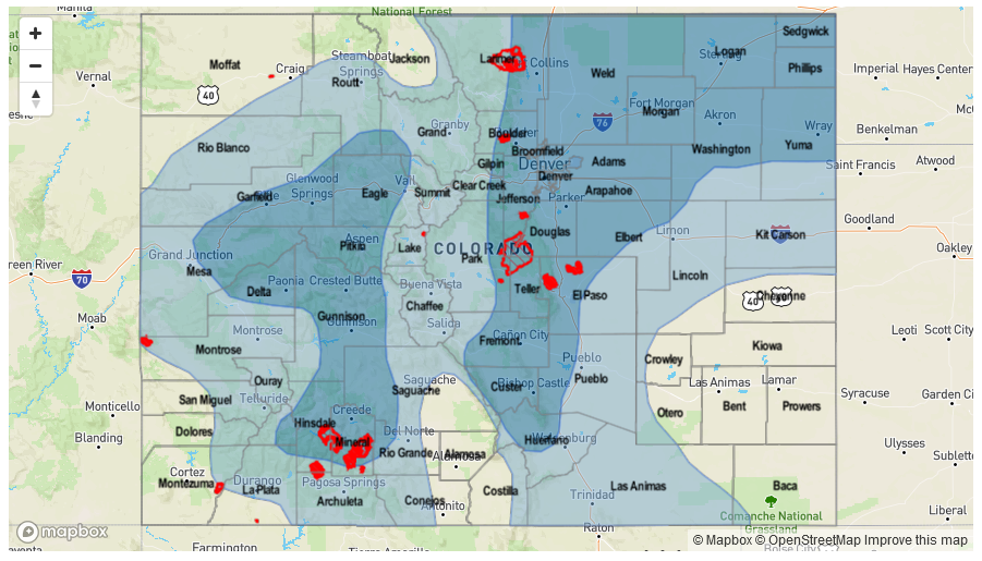
A fairly slow-moving upper-level low, combined with intensifying surface low pressure and the presence of a frontal boundary, will set Colorado up for an unsettled 3-day period of showers/thunderstorms. Scattered-to-widespread activity is expected, with swaths of greater than 1 inch of rain expected across portions of the Grand Valley, Central Mountains, San Juan Mountains, Front Range, Southeast Mountains, Urban Corridor, Palmer Ridge, Northeast Plains and Southeast Plains. Stay tuned to daily FTB’s for more information.

Event #3: Monday (05-22-2017) through Wednesday (05-24-2017)
No Apparent Threat Due to Uncertainty, But Climatology is Important
Uncertainty will keep this period from obtaining any flood threat designation, but climatology points toward the possibility with the upper-level pattern expected. Eastern Colorado will be under the greatest concern for strong-to-severe thunderstorms and heavy rainfall, but the presence of easterly low-level flow could push this back into the mountains and foothills, as well. No precipitation map will be drawn until more details come into focus. Stay tuned.