Issue Date: May 11th, 2017
Issue Time: 3:05PM EDT
Valid Dates: May 12 – May 26
 This afternoon’s water vapor imagery, below, continues to show a very active North Pacific jet stream that will continue to affect Colorado over the next 15 days. The first feature of note is the departing cut-off low-pressure system that affected the state over the past 3 days. As this continues to move away, Colorado will be increasingly influenced by a moderate strength ridge that will provide several days of warm and dry conditions. Certainly a welcome change after a string of days with severe weather and heavy rainfall.
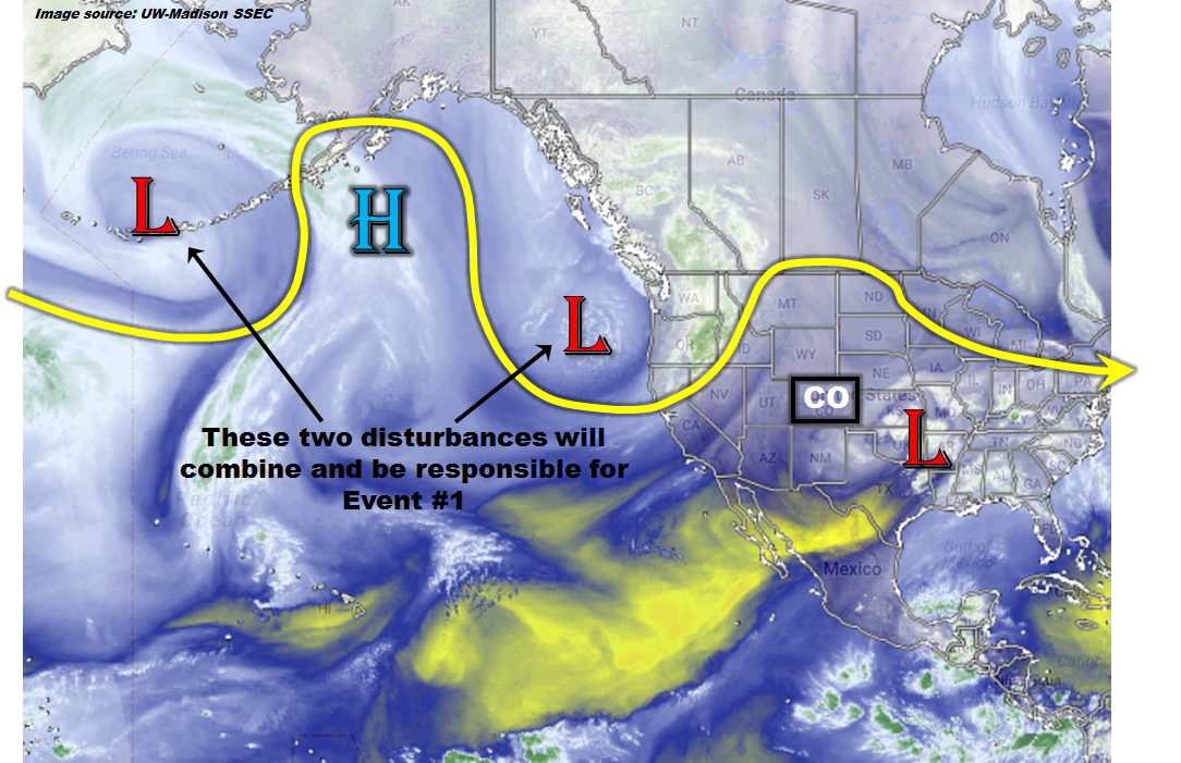
Turning our attention westwards, we see two low-pressure systems in the North Pacific, separated by a high pressure ridge. Despite the fact that the eastern feature is already entering the west coast of North America, it will be in no hurry to propagate eastward and will instead nearly stall out. Thereafter, guidance is in surprisingly good agreement that the two large-scale troughs will merge over the western US and thereafter begin to affect Colorado. This has been identified as Event #1. There is some uncertainty as to how long this event will affect the state and where exactly the low pressure will develop. However, an elevated flood threat appears likely.
Thereafter, a more zonal flow will develop over western North America. Seasonally warm temperatures are expected and several weak disturbances may affect the state. However, the next organized precipitation event does not appear to be in the works until the latter part of the 15-day period, when another trough affects Colorado.
Below we describe each of the two identified Events in more detail.
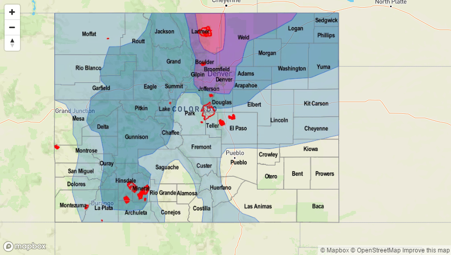
Event #1: Thursday (5/18) and Friday (5/19)
Elevated Flood Threat as another cut-off low pressure is likely to affect Colorado’s weather
Somewhat similar to the recent cut-off low pressure, this event will begin in earnest on Thursday as the cut-off enters the state either from the west or southwest. Current guidance is in very good agreement about the chances of heavy rainfall both Thursday and Friday. On Thursday, as the disturbance first affects the state, at least one round of thunderstorms is expected across a wide swath of the state, with the possible exception of the far southeast. Flash flooding will be possible along with hail, and gusty thunderstorm winds. Up to 1.5 inches of rainfall could fall, with the highest threat regions being the Palmer Ridge and into the Central Mountains. By Friday, as the system moves across the state, a deep easterly/southeasterly moisture feed will likely result in another round of showers and thunderstorms. The focus region this time will be in the Front Range along the Wyoming border. Flash flooding, debris slides and mud flows will be possible. It is possible that this event is upgraded to a High flood threat, so stay tuned.

Event #2: Thursday (5/25) and Friday (5/26)
No Anticipated Flood Threat at this time
A more zonal flow will provide Colorado with seasonable weather after Event #1. At this time, it appears another large-scale trough may enter the west coast by Wednesday 5/24. Thereafter, chances of widespread precipitation will increase as easterly winds bring in Gulf of Mexico moisture. The chances of rainfall exceeding 0.5 inches is uncertain at this time, so no precipitation map is provided.