FTO 07-13-2017: Copious Moisture Supports Early High Flood Threat

Issue Date: Thursday, July 13, 2017
Issue Time: 3PM MDT
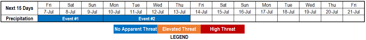
Valid Dates: 7/14-7/28

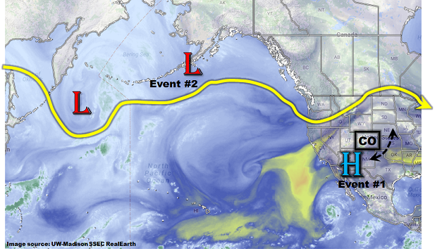
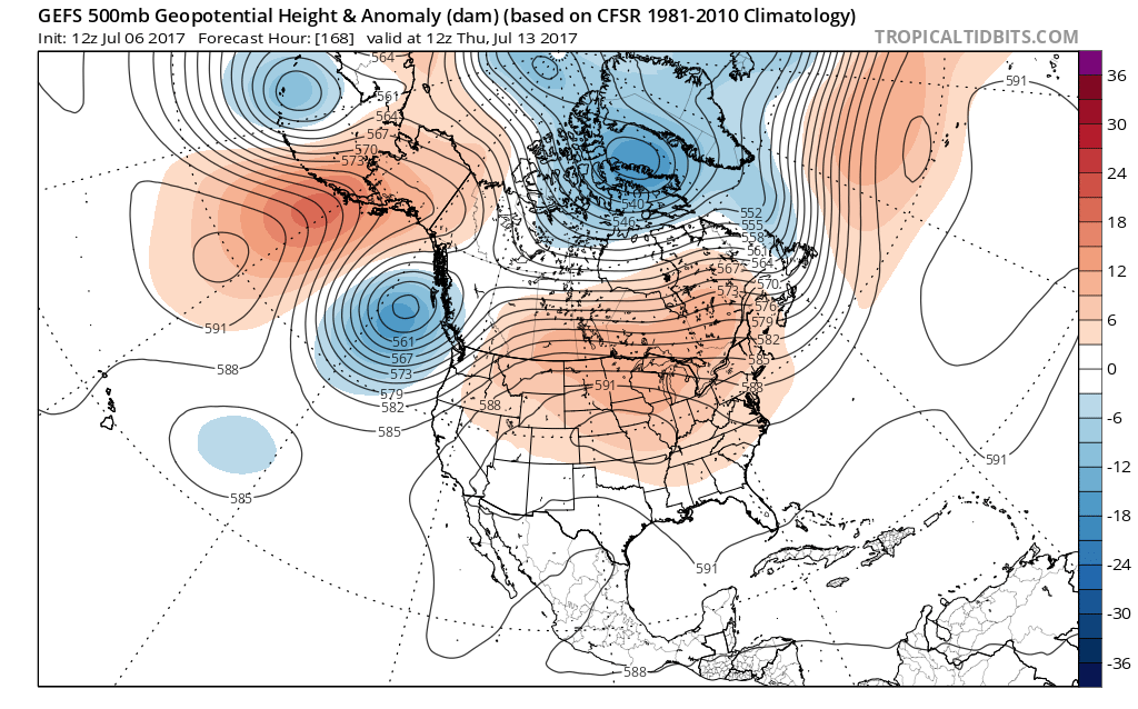
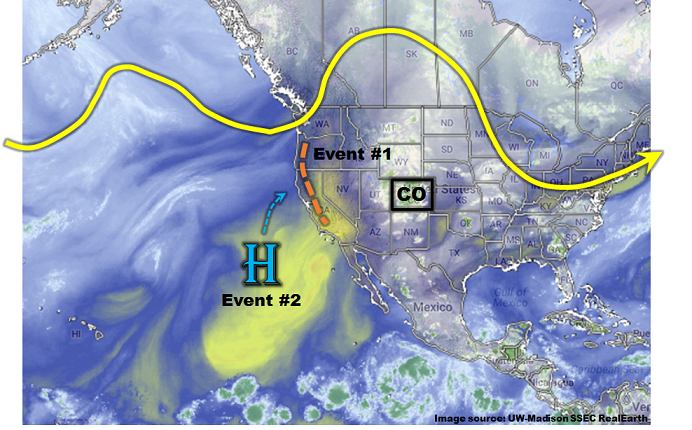
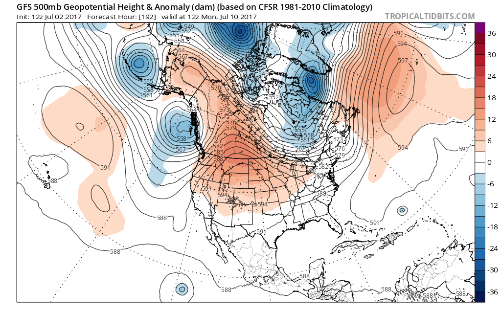
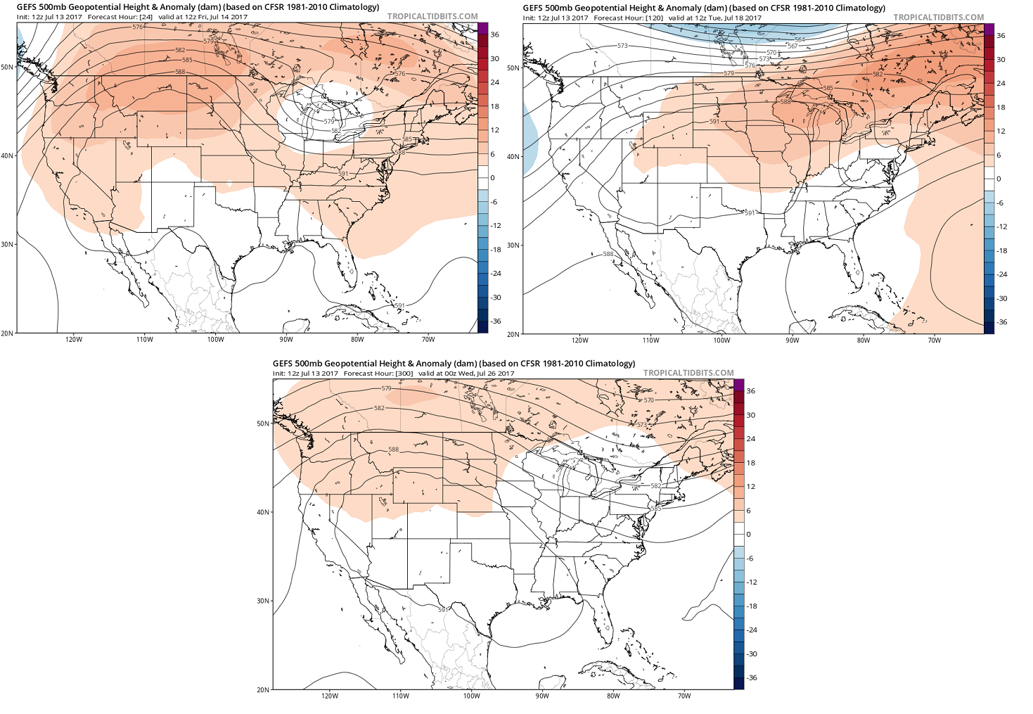
For the Flood Threat Outlook, one of our staple images is the North Pacific water vapor map. The rationale for this is that this map is a meaningful snapshot of current conditions and also a reasonable first guess at what the future may bring. For today’s Outlook, however, that map is just not very informative. Instead, the key to deciphering the weather pattern over the next 15 days is to look much closer to home. The three panel image, below, shows the forecasted mean 500-mb height anomaly from the GFS ensembles for day 1, day 5 and day 13 (clockwise). The take-away message is that, in the upper-levels of the atmosphere, there will be surprisingly little change in the pattern. A weak-to-moderate upper-level ridge is expected to maintain an influence over western North America.

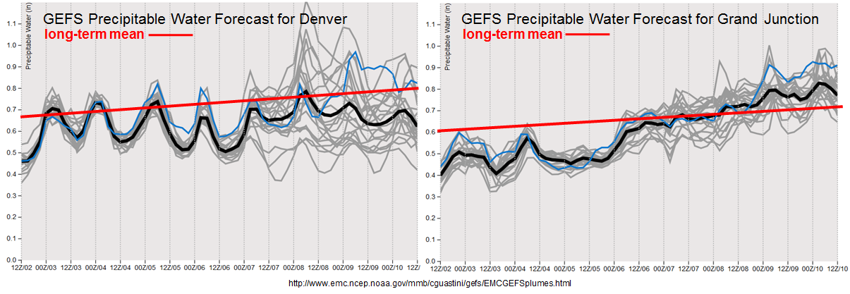
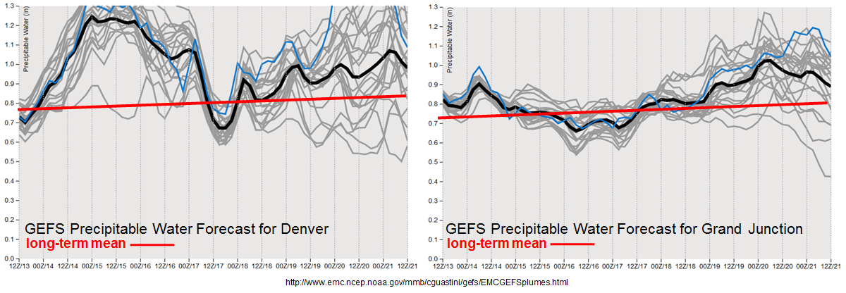
Unfortunately, during this time of year, the upper-level atmosphere provides surprising little translation into precipitation intensity especially across our state. However, the fact that the anomalous ridge will be north of Colorado for the duration of the Outlook is important, because such a position is typically associated with above normal Precipitable Water (PW) across most of Colorado. [Some early research has suggested that this is due to an increased frequency of surface high pressures moving southward out of Canada, providing fresh surges of upslope, moist air from the southeast.] Indeed, as seen in the forecasted PW values in the GFS ensembles, above normal values are expected throughout almost the entirety of the Outlook period. In fact, “above normal” may not be a strong enough word, since over the 7/14-7/16 period, significantly above normal PW (and though not shown here, low-level moisture as well) is expected to affect Colorado. Although PW is a strong predictor of precipitation potential, one mitigating factor to the rainfall threat will be a lack of upper-level dynamics. At this point in the summer, this is not much of a constraint, as we saw with the widespread heavy rainfall on Wednesday 7/12 despite rather weak upper-level dynamics. However, the weak steering winds tend to favor more isolated nature of the heavy rainfall threat, rather than a widespread/evolving storm cluster-type threat that is associated with shortwave disturbances.

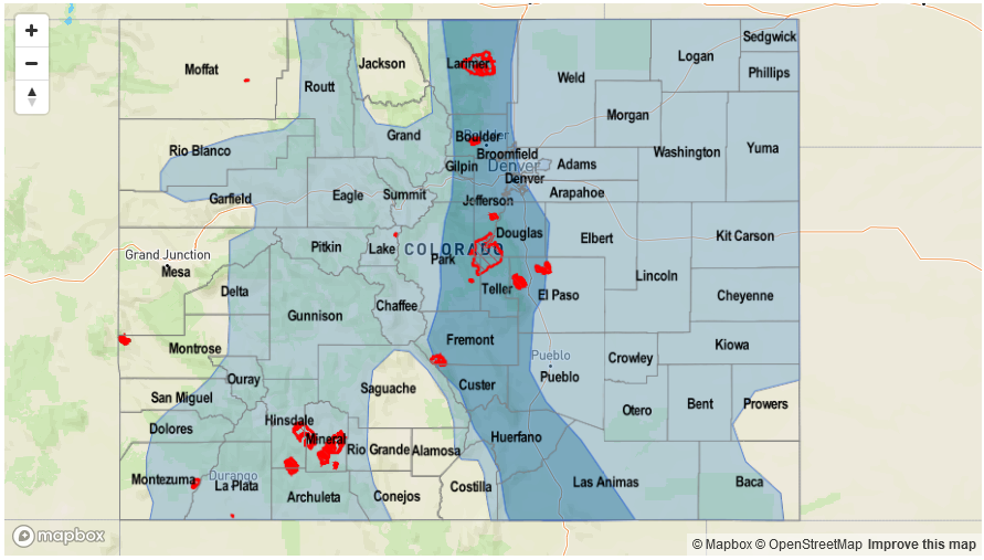
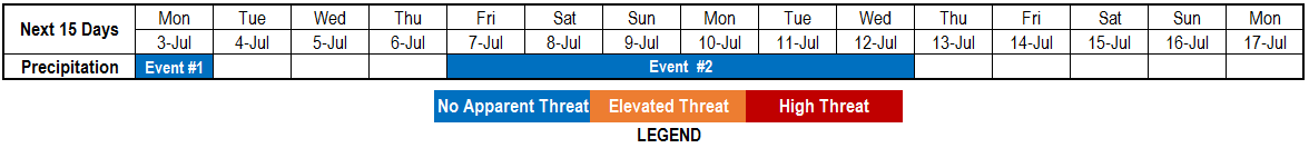
We have identified two organized precipitation events for this 15-day Outlook. Below each event is described in more detail.

Event #1: Friday (7/14) through Monday (7/17)

High Flood Threat as very high moisture content supports at least isolated heavy rainfall

Surface high pressure will quickly move southward out of Canada, providing “return” southeasterly flow into Colorado. Strong moisture transport will result in PW values potentially exceeding 1.5 inches across eastern parts of the state – this is an extremely high reading that is very unusual even for eastern Colorado. With a lack of upper-level forcing, the main forcing mechanisms for this event will be (i) frontal dynamics on Friday and Saturday, and then (ii) climatological diurnal anabatic (i.e. upslope) flow from quick morning heating. Expect daily rounds of showers and thunderstorms, first focused on northeast Colorado on Friday, then east-central and southeast Colorado later in the event. With the high moisture content, max 1-hour rainfall up to 2.7 inches will be possible across eastern areas with up to 1.9 inches closer to the mountains and up to 1.1 inches across the western slope. Repeated storms moving a given locale will be of concern and max 3-hour rainfall up to 3.5 inches looks like a possibility on Friday – Sunday. Isolated flash flooding will be likely, along with debris slides and mud flows as wet soils become an increasing concern due to repeated rainfall. Rainfall intensities are expected to drop somewhat by Monday as higher moisture leaves the state. Please stay tuned to daily Flood Threat Bulletins for a much more detailed look at this event as it transpires.

Legend

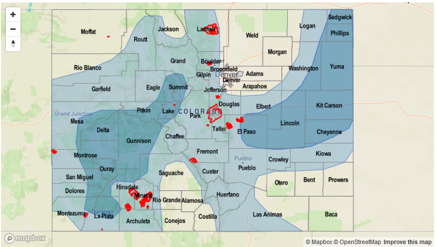
Event #2: Wednesday (7/19) through Saturday (7/22)

Elevated Flood Threat as cool front provides focus for heavy rainfall

After a brief return to heat following Event #1, another surface high pressure is expected to bring in a fresh cool front starting Wednesday, 7/19. Scattered to numerous showers and thunderstorms will accompany the front’s passage across northeast Colorado. Max 1-hour rainfall up to 2.3 inches (east) and 1.7 inches (central) will contribute to an isolated flash flooding threat. Across the western slope, moisture content is uncertain, and the flood threat looks to be subdued at the moment. With current guidance again suggesting very high moisture availability across eastern Colorado for this event, it is possible that an upgrade to a High threat will be required during the next Outlook.

Legend

FTO 07-10-2017: Incredibly Persistent Pattern Continues To Favor Heat; Rainfall, Not So Much

Issue Date: Monday, July 10, 2017
Issue Time: 3PM MDT
Valid Dates: 7/11-7/25

Once again, the upper-level ridge that is typically a staple over western North America during the summer months, continues to maintain a firm grasp on Colorado’s weather. Although it is common to see the ridge centered somewhere in close proximity to Colorado, the past 7-14 days have seen remarkably little variation in the ridge position and intensity. Furthermore, there has been a near absence of any upper-level disturbances. Interestingly, it appears this pattern will persist for nearly the entire period covered by this 15-day Flood Threat Outlook. Although the upper-level ridge is expected to wobble around a bit (see water vapor image, below), it will remain centered very close to Colorado. Such a pattern is simply not conducive for any kind of organized rainfall in our state. That is not to say there will not be heavy rainfall, but such activity is expected to remain of a very isolated nature.

We have identified two precipitation events for this Outlook. The first event will be associated with a surge of monsoonal moisture traversing the state over the next 72 hours. An elevated flood threat is anticipated for isolated flash flooding. Notably, the western slope will get much needed rainfall. After a break in action, another event is identified later in the Outlook. Current guidance suggests influences from both the main jet stream as well as possible monsoonal moisture (and inverted trough from the south). Unfortunately, it is too soon to determine if a flood threat will accompany the second event.

What is much more certain is the incredibly persistent above average temperatures expected for at least a portion of the state over nearly the entire Outlook (see image below). This follows on the heels of a very warm June, almost setting in stone above average July temperatures, at least on a statewide level.

Below we describe each of the two identified precipitation events in more detail.

Event #1: Tuesday (7/11) through Thursday (7/13)

Elevated Flood Threat as monsoonal surge treks across the state

A surge of monsoon moisture will move across Colorado starting on Tuesday, supporting heavier rainfall both west and east of the Continental Divide. First on Tuesday, scattered to numerous showers and storms are expected over the San Juans, Central Mountains and Northern Mountains. With little shear and negligible upper-level forcing, only relatively brief heavy rainfall is expected. Max 1-hour rain rates could approach 1 inch per hour in favored parts of the western Central Mountains and San Juans. Isolated flash flooding, mud flows and debris slides will be possible, especially given the parched soil that will promote initial rapid runoff. Meanwhile, out east, a round of showers and storms is expected to develop mainly over the Palmer Ridge and track eastward. With plenty of moisture in place, quick bursts of heavy rainfall, to the tune of 1.25 – 1.5 inches per hour will accompany the strongest cells. Gusty winds will be possible in cells that are light on moisture content as rain-cooled downdrafts descend to the surface. Scattered shower and storm activity is expected for Wednesday though with lower rainfall rates. By Thursday, a cool front will graze eastern Colorado and support higher rainfall rates, up to 1.5 inches per hour. Isolated flash flooding will be possible.

Legend

Event #2: Wednesday (7/19) through Sunday (7/23)

No Apparent Flood Threat as a combination of disturbances approach Colorado

A persistent ridge will reform after Event #1, causing above average temperatures statewide (especially out west). The first signs of a possible pattern shift may be on the horizon as a disturbance currently situated across the central Pacific begins to move eastward. At the same time, the upper-level ridge is expected to move east allowing for some easterly transport of relatively moist area into Colorado. A prolonged period of unsettled weather may be on tap for both eastern and western Colorado. However, currently, there is only marginal confidence for widespread rainfall, and even less confidence of heavy rainfall. The precipitation map shows the possibility of rainfall east and west of the Divide but amounts are expected to remain below 1.0 inch. Thus, flooding is not expected at this time. Stay tuned to Thursday’s Flood Threat Outlook for an update on this event.

Legend

FTO 07-06-2017: First Monsoon Surge On The Horizon; Heat Continues Statewide

Issue Date: Thursday, July 6th, 2017
Issue Time: 3PM MDT
Valid Dates: 7/7-7/21

Just like the last Flood Threat Outlook, we do not have to look far away from home to foresee what is in store for Colorado’s weather during the next 15-day period. Shown in the water vapor image, below, we see a strong upper-level high pressure ridge currently positioned just west of our state. With strong subsidence underneath and to the east of it, very hot temperatures of 5-15F above normal have been the rule over the past few days. Today’s guidance is in remarkably good agreement that a relatively persistent pattern will continue over at least the next 7-10 days and perhaps even through the entire 15-day period. This pattern will be marked by the above average intensity upper-level ridge over central and western North America and a trough of low pressure off the west coast. Despite the pattern’s persistence, subtle shifts in the ridge’s position will have sizeable implications on Colorado’s precipitation chances.

There are two precipitation events that have been identified for this Outlook. The first event will be courtesy of a surface high pressure and attendant cool front that will sweep across mainly eastern Colorado on Friday. This will increase shower and storm chances out east for Friday, with decreasing coverage on Saturday and Sunday. With average to above average Precipitable water expected, short-term heavy rainfall will be possible but flooding is not expected. The second event will be the season’s first organized surge of monsoon moisture from the southwest. This will begin by early next week but peak by next Wednesday or Thursday, as the ridge wobbles far enough east to promote southerly moist flow statewide (see the forecasted 500-mb height anomaly pattern below). Although isolated heavy rainfall will be likely during Event #2, the lack of confidence in the moisture availability (especially regarding near-surface moisture) does not support an elevated flood threat at this time.

After Event #2 guidance continues to show a persistent high pressure ridge expected over or north of Colorado, supporting above normal temperatures for the tail end of the 15-day period. This can be seen below using the Saint Louis University’s CIPS analog guidance, which shows probabilities of temperature being above or below normal. A noteworthy impact of this would be a continued risk of elevated fire danger, which research has shown is dictated by prolonged periods of above normal temperatures.

Below we describe each of the two identified precipitation events in more detail.

Event #1: Friday (7/7) through Sunday (7/9)

No Apparent Flood Threat as cool front traverses across eastern Colorado

A cool front will move southward across eastern Colorado on Friday, providing an enhanced focus for shower and storm activity. Short-term heavy rainfall will be possible mainly across eastern Colorado, though the higher elevations could also experience isolated heavy rainfall producing storms. Up to 0.6 inches in 30 minutes will be possible except for far eastern areas where up to 1.5 inches per hour will be possible. These intensities are below flash flood levels, and flooding is not expected. As the front losing momentum in southern Colorado, the diurnal upslope flow will allow for better storm coverage across the Southeast Mountains, Raton Ridge and Southeast Plains on Saturday and Sunday. However, with no upper-level support, thunderstorm activity is expected to remain of the pulse variety with only 15-30 minutes of heavy rainfall under any given storm. Up to 0.7 inches of rainfall in 30 minutes will be possible.

West of the Continental Divide, increasing low-level moisture will continue to support isolated to scattered storm activity. Up to 0.6 inches per hour is possible here. With these values being well below flood-intensity thresholds, flooding is currently not expected.

Legend

Event #2: Monday (7/10) through Thursday (7/13)

No Apparent Flood Threat at this time as moisture and precipitation chances finally increase for western slope

The first organized surge of monsoon moisture is expected to affect Colorado starting early next week. Precipitable water values will increase to near 1 inch along the Utah border. Daily rounds of afternoon/evening shower and storm activity will increase in coverage on Monday and Tuesday, peaking on Wednesday and Thursday. With only weak wind shear, only short-term heavy rainfall is expected. Max 30-minute rates up to 0.6 inches will be possible. However, with the prolonged duration of the event, the rainfall will gradually add up. Over 1.5 inches of total event rainfall will be possible along the climatologically favored southern slopes of the San Juans and perhaps the Central Mountains. At this time, there is no apparent flood threat. However, it is possible that this event will be upgraded to an elevated flood threat by Monday’s Outlook. Stay tuned.


Legend

FTO 07-02-2017: Relief On The Way For Dry Western Slope; Heat Persists Elsewhere

Issue Date: Sunday, July 2nd, 2017
Issue Time: 4PM MDT
Valid Dates: 7/3-7/17

For almost all Flood Threat Outlooks, it is usually necessary to look far westward across the Pacific Ocean to get a heads up on Colorado’s precipitation chances over the coming weeks. Interestingly, this is not the case during this 15-day Outlook. As can be seen in the water vapor image, below, the domain includes only a bit of the eastern Pacific. After the passage of a weak disturbance, identified as Event #1 that will bring light to moderate precipitation mainly for eastern areas, the atmospheric pattern becomes remarkably persistent. This is due to the development and migration of a blocking ridge to become situated along the Montana/Saskatchewan border.

As can be seen in the long-range 500-mb height anomaly forecast, below, once this ridge sets up across southern Canada by later this week, it will move little over the next 7 or so days. In fact, there is a high degree of consistency across ensemble guidance (both GFS and ECMWF) that this will occur. With such a ridge position, significantly above average temperatures can be expected immediately under the anomalous ridge. However, Colorado will lie on its southern periphery meaning the temperature signal is weaker (although generally above average temperatures are expected throughout this entire Outlook period). The more notable impact of this ridge position is that it is far enough north to allow for the advection of relatively moist easterly flow into southern Colorado, including west of the Continental Divide. This will certainly be welcome news for western slope residents who have been in a notable dry streak throughout most of June. This pattern resembles that of the desert southwest monsoon; but without distinct moisture surges, we avoid calling it as such for the time being.

Looking at the ensemble Precipitable Water forecast plumes, below, note the persistent increase in moisture at Grand Junction. By July 7th, the PW is forecasted to finally get above average across western Colorado, for the first time in weeks. That is the good news. The bad news is that while PW is a good predictor of precipitation chances, it is a rather poor predictor of precipitation amount. Thus, we have stayed conservative for this Outlook and have not posted an elevated flood threat for western Colorado yet, because at this time rainfall rates are expected to stay below flood intensity levels. However, given the persistence of the pattern, this may certainly change as the finer details become clearer during the next 3-5 days.

Below we describe each of the two identified precipitation events in more detail.

Event #1: Monday (7/3)

No Apparent Flood Threat as disturbance bring light rainfall across Colorado

A weak disturbance will quickly move across Colorado on Monday morning, and will likely support some isolated to scattered shower and thunderstorm activity mainly across eastern areas. Storm motion will be relatively high, and moisture content will be marginal. Thus, flooding is not currently anticipated as rainfall is expected to stay below 0.75 inches.

Event #2: Friday (7/7) through Wednesday (7/12)

No Apparent Flood Threat as moisture and precipitation chances finally increase for western slope

A persistent pattern will bring easterly flow into southern Colorado, allowing for the return of moisture to the area. With plenty of morning sunshine expected daily, generating instability will not be an issue and scattered to numerous shower and storm activity is expected across southwest and southern Colorado. However, low level moisture supply currently looks to be marginal. Without organized disturbances, only popcorn thunderstorms are currently expected, generally yielding up to 0.5 inches of quick rainfall, but not much of a flood threat. Nonetheless, with such a prolonged event, total rainfall will add up over time, and over 1.5 inches is looking more likely for southwest Colorado. Wet soils could become an issue later in the event, which may necessitate an elevated flood threat. However, without knowledge of exact location, this is currently too speculative to act upon. Stay tuned!

Legend