Issue Date: Thursday, July 13, 2017
Issue Time: 3PM MDT
Valid Dates: 7/14-7/28
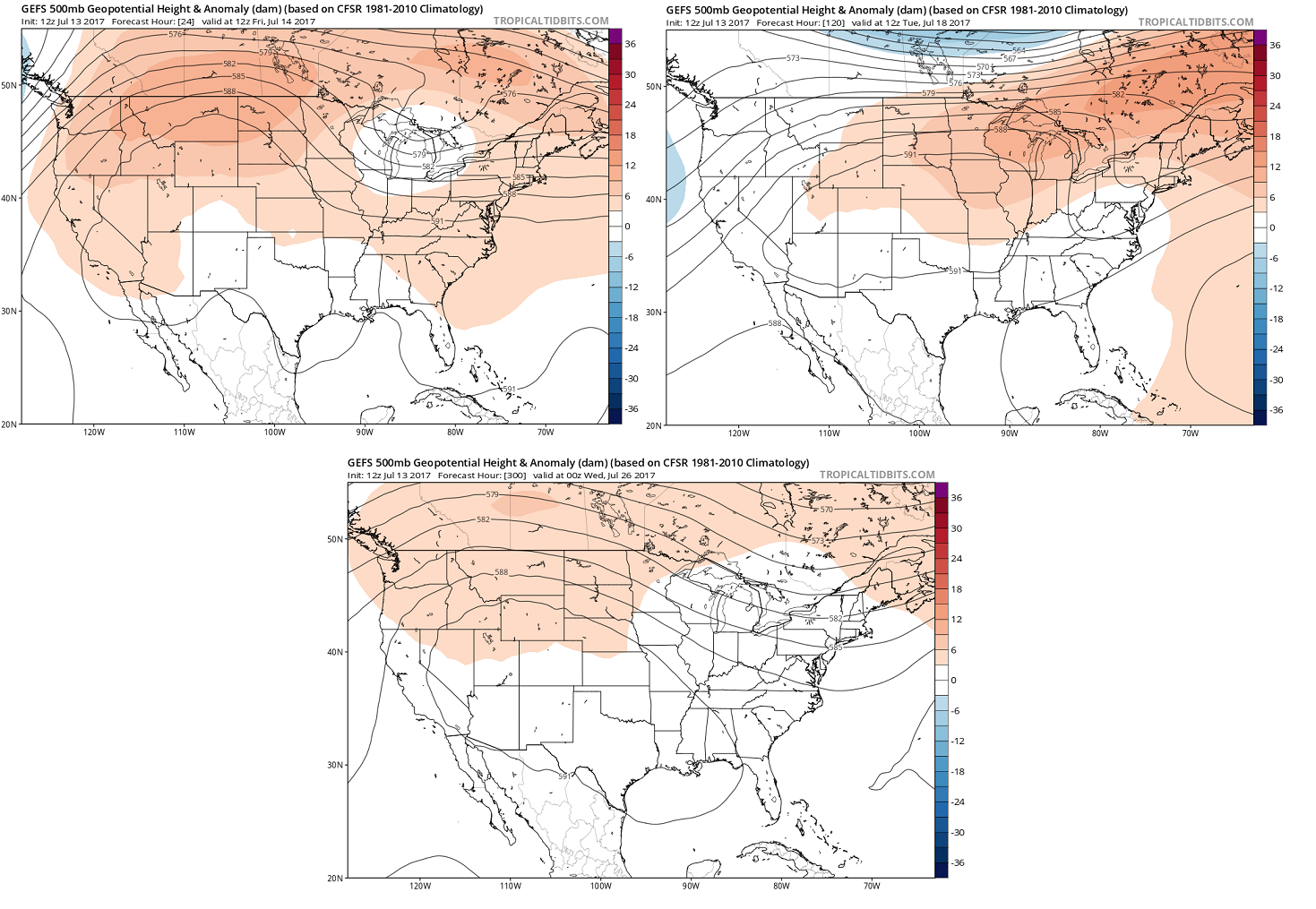
For the Flood Threat Outlook, one of our staple images is the North Pacific water vapor map. The rationale for this is that this map is a meaningful snapshot of current conditions and also a reasonable first guess at what the future may bring. For today’s Outlook, however, that map is just not very informative. Instead, the key to deciphering the weather pattern over the next 15 days is to look much closer to home. The three panel image, below, shows the forecasted mean 500-mb height anomaly from the GFS ensembles for day 1, day 5 and day 13 (clockwise). The take-away message is that, in the upper-levels of the atmosphere, there will be surprisingly little change in the pattern. A weak-to-moderate upper-level ridge is expected to maintain an influence over western North America.
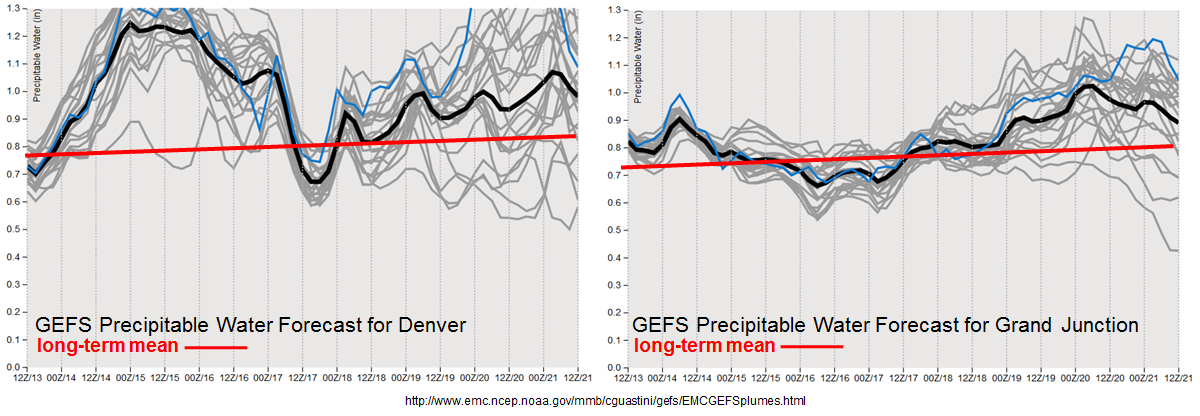
Unfortunately, during this time of year, the upper-level atmosphere provides surprising little translation into precipitation intensity especially across our state. However, the fact that the anomalous ridge will be north of Colorado for the duration of the Outlook is important, because such a position is typically associated with above normal Precipitable Water (PW) across most of Colorado. [Some early research has suggested that this is due to an increased frequency of surface high pressures moving southward out of Canada, providing fresh surges of upslope, moist air from the southeast.] Indeed, as seen in the forecasted PW values in the GFS ensembles, above normal values are expected throughout almost the entirety of the Outlook period. In fact, “above normal” may not be a strong enough word, since over the 7/14-7/16 period, significantly above normal PW (and though not shown here, low-level moisture as well) is expected to affect Colorado. Although PW is a strong predictor of precipitation potential, one mitigating factor to the rainfall threat will be a lack of upper-level dynamics. At this point in the summer, this is not much of a constraint, as we saw with the widespread heavy rainfall on Wednesday 7/12 despite rather weak upper-level dynamics. However, the weak steering winds tend to favor more isolated nature of the heavy rainfall threat, rather than a widespread/evolving storm cluster-type threat that is associated with shortwave disturbances.
We have identified two organized precipitation events for this 15-day Outlook. Below each event is described in more detail.
Event #1: Friday (7/14) through Monday (7/17)
High Flood Threat as very high moisture content supports at least isolated heavy rainfall
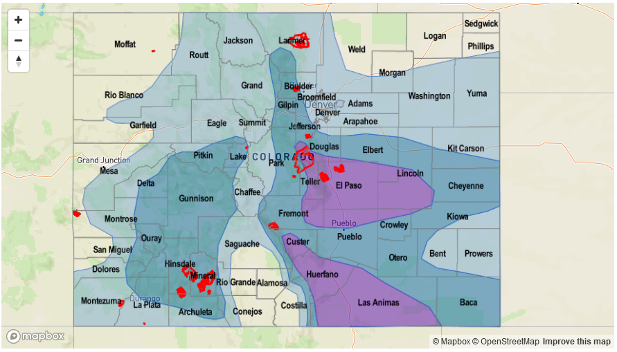
Surface high pressure will quickly move southward out of Canada, providing “return” southeasterly flow into Colorado. Strong moisture transport will result in PW values potentially exceeding 1.5 inches across eastern parts of the state – this is an extremely high reading that is very unusual even for eastern Colorado. With a lack of upper-level forcing, the main forcing mechanisms for this event will be (i) frontal dynamics on Friday and Saturday, and then (ii) climatological diurnal anabatic (i.e. upslope) flow from quick morning heating. Expect daily rounds of showers and thunderstorms, first focused on northeast Colorado on Friday, then east-central and southeast Colorado later in the event. With the high moisture content, max 1-hour rainfall up to 2.7 inches will be possible across eastern areas with up to 1.9 inches closer to the mountains and up to 1.1 inches across the western slope. Repeated storms moving a given locale will be of concern and max 3-hour rainfall up to 3.5 inches looks like a possibility on Friday – Sunday. Isolated flash flooding will be likely, along with debris slides and mud flows as wet soils become an increasing concern due to repeated rainfall. Rainfall intensities are expected to drop somewhat by Monday as higher moisture leaves the state. Please stay tuned to daily Flood Threat Bulletins for a much more detailed look at this event as it transpires.
Event #2: Wednesday (7/19) through Saturday (7/22)
Elevated Flood Threat as cool front provides focus for heavy rainfall
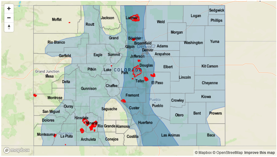
After a brief return to heat following Event #1, another surface high pressure is expected to bring in a fresh cool front starting Wednesday, 7/19. Scattered to numerous showers and thunderstorms will accompany the front’s passage across northeast Colorado. Max 1-hour rainfall up to 2.3 inches (east) and 1.7 inches (central) will contribute to an isolated flash flooding threat. Across the western slope, moisture content is uncertain, and the flood threat looks to be subdued at the moment. With current guidance again suggesting very high moisture availability across eastern Colorado for this event, it is possible that an upgrade to a High threat will be required during the next Outlook.


