Issue Date: Sunday, July 2nd, 2017
Issue Time: 4PM MDT
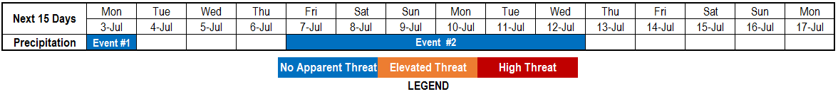
Valid Dates: 7/3-7/17
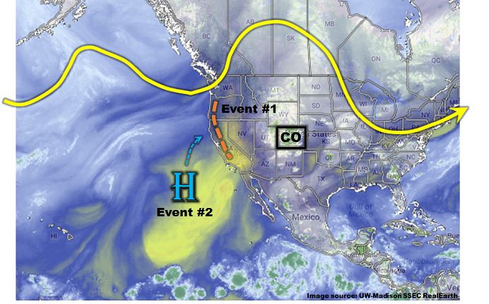
For almost all Flood Threat Outlooks, it is usually necessary to look far westward across the Pacific Ocean to get a heads up on Colorado’s precipitation chances over the coming weeks. Interestingly, this is not the case during this 15-day Outlook. As can be seen in the water vapor image, below, the domain includes only a bit of the eastern Pacific. After the passage of a weak disturbance, identified as Event #1 that will bring light to moderate precipitation mainly for eastern areas, the atmospheric pattern becomes remarkably persistent. This is due to the development and migration of a blocking ridge to become situated along the Montana/Saskatchewan border.
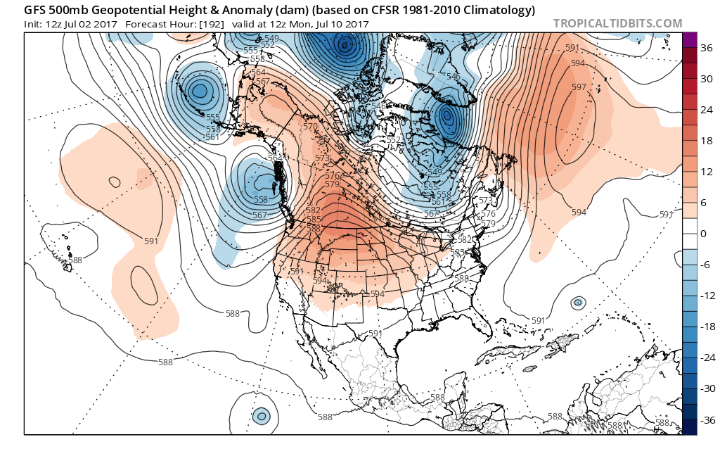
As can be seen in the long-range 500-mb height anomaly forecast, below, once this ridge sets up across southern Canada by later this week, it will move little over the next 7 or so days. In fact, there is a high degree of consistency across ensemble guidance (both GFS and ECMWF) that this will occur. With such a ridge position, significantly above average temperatures can be expected immediately under the anomalous ridge. However, Colorado will lie on its southern periphery meaning the temperature signal is weaker (although generally above average temperatures are expected throughout this entire Outlook period). The more notable impact of this ridge position is that it is far enough north to allow for the advection of relatively moist easterly flow into southern Colorado, including west of the Continental Divide. This will certainly be welcome news for western slope residents who have been in a notable dry streak throughout most of June. This pattern resembles that of the desert southwest monsoon; but without distinct moisture surges, we avoid calling it as such for the time being.
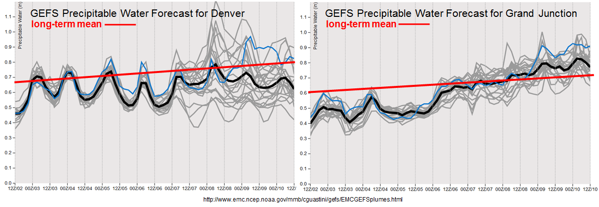
Looking at the ensemble Precipitable Water forecast plumes, below, note the persistent increase in moisture at Grand Junction. By July 7th, the PW is forecasted to finally get above average across western Colorado, for the first time in weeks. That is the good news. The bad news is that while PW is a good predictor of precipitation chances, it is a rather poor predictor of precipitation amount. Thus, we have stayed conservative for this Outlook and have not posted an elevated flood threat for western Colorado yet, because at this time rainfall rates are expected to stay below flood intensity levels. However, given the persistence of the pattern, this may certainly change as the finer details become clearer during the next 3-5 days.
Below we describe each of the two identified precipitation events in more detail.
Event #1: Monday (7/3)
No Apparent Flood Threat as disturbance bring light rainfall across Colorado
A weak disturbance will quickly move across Colorado on Monday morning, and will likely support some isolated to scattered shower and thunderstorm activity mainly across eastern areas. Storm motion will be relatively high, and moisture content will be marginal. Thus, flooding is not currently anticipated as rainfall is expected to stay below 0.75 inches.
Event #2: Friday (7/7) through Wednesday (7/12)
No Apparent Flood Threat as moisture and precipitation chances finally increase for western slope
A persistent pattern will bring easterly flow into southern Colorado, allowing for the return of moisture to the area. With plenty of morning sunshine expected daily, generating instability will not be an issue and scattered to numerous shower and storm activity is expected across southwest and southern Colorado. However, low level moisture supply currently looks to be marginal. Without organized disturbances, only popcorn thunderstorms are currently expected, generally yielding up to 0.5 inches of quick rainfall, but not much of a flood threat. Nonetheless, with such a prolonged event, total rainfall will add up over time, and over 1.5 inches is looking more likely for southwest Colorado. Wet soils could become an issue later in the event, which may necessitate an elevated flood threat. However, without knowledge of exact location, this is currently too speculative to act upon. Stay tuned!