FTO 09-07-2017: Above Normal Moisture Hangs Around, Supports Brief Elevated Flood Threat

Issue Date: Thursday, September 7, 2017
Issue Time: 12PM MDT
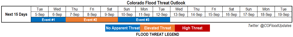
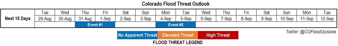
Valid Dates: 9/8 – 9/22

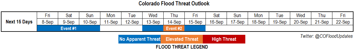
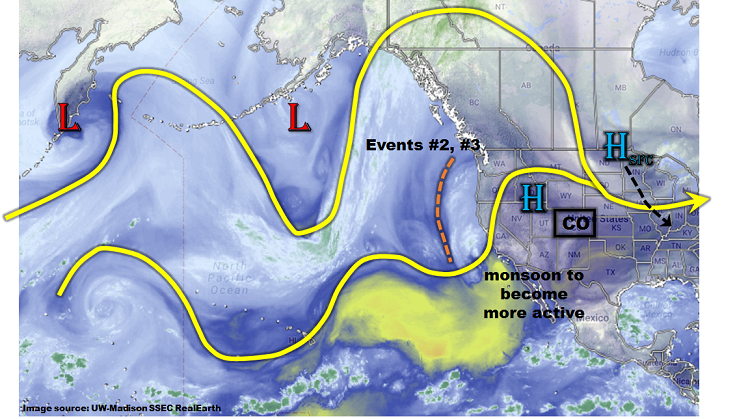
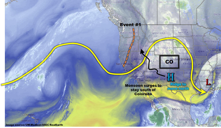
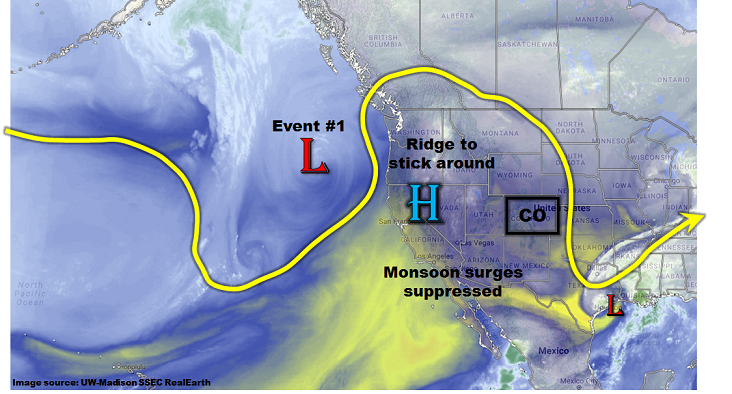
A high-amplitude jet stream is seen this morning across western North American with a large upper-level ridge over the Great Plains and a trough off the coastline. Within the trough are two embedded disturbances, or shortwaves, that will be the main features controlling Colorado’s weather over the next 7-10 days. Two precipitation events have been identified for the 15-day Outlook, corresponding to each shortwave. The first event will be mainly light to moderate precipitation as low-level moisture remains marginal. The second event, while more uncertain because the shortwave is expected to cut off from the main flow, has more potential to cause heavier rainfall due to a supply of higher moisture content available for it to draw from.

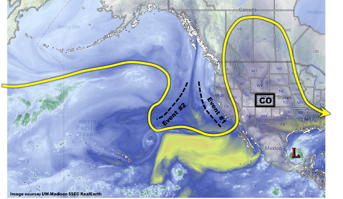
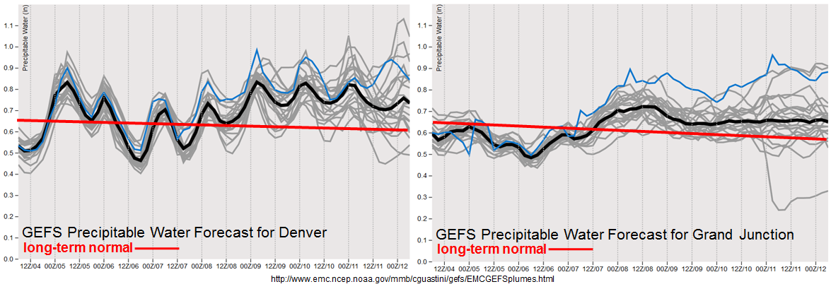
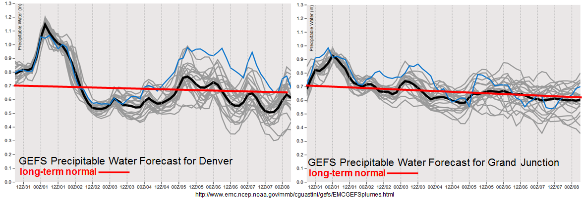
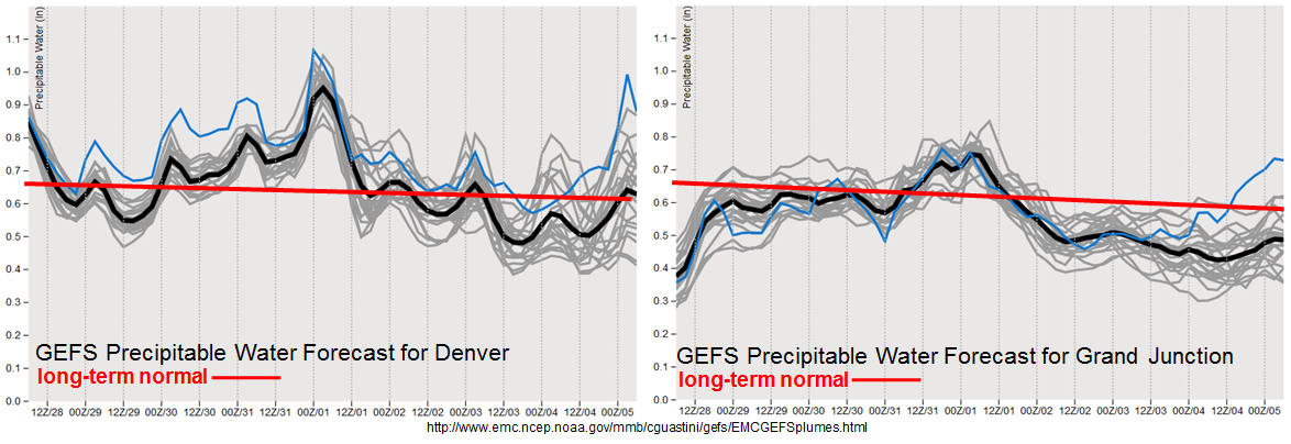
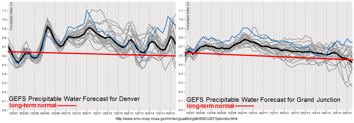
As shown in the forecasted Precipitable Water plumes, below, moisture content is expected to remain at or above seasonal normal through the majority of the next 10 day period. However, seasonal “normal” is entering a period of rapid decline. For example, at Denver, normal PW decreases by about 5% every week during September and October. Thus, above normal does not have the same impact as it did during July and August. Nonetheless, note that during Event #2, there is a potential to approach PW of 1 inch, which combined with other factors, can cause heavy rainfall east of the Continental Divide. To the west, it is looking more likely that the Southwest monsoon may be waning, at least for Colorado. Monsoon surges continue in Arizona, but moisture is not expected to make it far enough north to support heavy rainfall across the Western Slope, even over the climatologically favored San Juans.

Below we describe each of the two identified precipitation events in more detail.

Event #1: Friday (9/8) through Sunday (9/10)

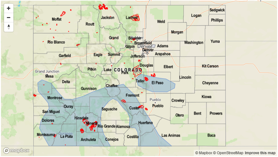
No Apparent Flood Threat but increase in PM showers and weak storms likely for San Juans

A weak shortwave will approach Colorado from the west, causing a slight increase in rainfall coverage mainly across the San Juan mountains. Daily round of storms could produce up to 0.5 inches per hour of rainfall, locally, with up to 1 inch could fall over the entire period of the Event. However, flooding is not expected. Furthermore, storm coverage outside of the San Juans is expected to be rather limited.

Legend

Event #2: Wednesday (9/13) through Friday (9/15)

Brief Elevated Flood Threat as cut-off low finally moves east

Despite a considerable amount of uncertainty remaining regarding timing, it does appear that the expected cut-off low will move eastward out of the eastern Pacific early next week. The system will move slow enough to allow for moisture return across most of Colorado. An increase in afternoon and evening shower and storm activity is expected over the San Juans, Southeast Mountains, Raton Ridge and Palmer Ridge. Currently, it appears that Thursday could have a brief Elevated flood threat as the main disturbance moves overhead. With Precipitable Water values as high as 1 – 1.1 inches east of the Continental Divide, isolated heavy rainfall up to 1.7 inches per hour (east) and 1.2 inches per hour (west) could be possible. Fire scars in the Southeast Mountains will need to be watched since even 0.5 inches of rain per hour could cause excessive runoff.

Legend

FTO 09-04-2017: A More Active Period Is Expected Statewide, Starting With The Cool Front Passage

Issue Date: Monday, September 4, 2017
Issue Time: 12:25PM MDT
Valid Dates: 9/5-9/19

After a brief lull, active weather is expected to return to Colorado this week, though active weather does not necessarily translate to heavy rainfall this time of year. As shown in the water vapor image below, a split flow pattern is currently noted over the eastern North Pacific Ocean. Closer to home, a strong fall cold front is being accompanied southward by a surface high pressure ridge across the northern Great Plains. The frontal passage will result in up to a 30F drop in afternoon high temperatures from Monday to Tuesday for parts of eastern Colorado (no such relief will occur west of the Continental Divide). The aforementioned split flow pattern will be key to deciphering precipitation chances for this Labor Day edition of the 15-day Flood Threat Outlook. In particular the feature of most interest is the trough currently positioned west of the North American coast. This feature is expected to remain nearly stationary over the next 5-7 days, while ejecting disturbances both to the north and south. The implications are interesting for Colorado because a south/southwesterly flow aloft is conducive for transporting monsoon moisture and precipitation for the western slope. Meanwhile, embedded shortwaves in the northern jet stream are expected to provide at least slight increases in precipitation coverage and intensity east of the Continental Divide.

In all, we foresee three precipitation events for this Outlook, though there will be relatively little demarcation between each event. Event #1 will be rainfall activity associated with the frontal passage, expected to last through Wednesday with No Apparent Flood Threat. Event #2 will be the approach of the eastern Pacific trough that may provide isolated heavy rainfall east of the Continental Divide as well as across Southwest Colorado. Event #3 will be due to the presence of residual moisture that will provide scattered diurnal storms across the High Country, with a possible eastward extension into the Plains. In all, the forecast Precipitable Water (PW) plumes, below, show that moisture at Denver and Grand Junction is expected to stay above to well-above climatological levels for early September. In turn, this suggests above normal precipitation chances, though confidence in heavy rainfall is weaker.

Below we describe each of the three identified precipitation events in more detail.

Event #1: Tuesday (9/5) and Wednesday (9/6)

No Apparent Flood Threat as front passage leaves residual moisture in southern and southwestern areas.

Daily rounds of isolated to widely scattered showers and thunderstorms are expected in the Southeast Mountains and San Juans on Tuesday and Wednesday. Instability will be limited and moisture will remain marginal so daily rainfall amounts of up to 0.5 inches are expected. The best coverage will be in the San Juans. Elsewhere, northeast Colorado will see a tremendous cool-down on Tuesday, followed by a rapid warm-up on Wednesday. Flooding is not expected with this event.

Event #2: Thursday (9/7) through Saturday (9/9)

Low-end Elevated Flood Threat for mainly isolated heavy rainfall and flash flooding

As the trough approaches Colorado, an increase in precipitation chances is expected statewide. Precipitable water is expected to increase to 0.8 – 1.0 inch out west and up to 1.2 inches out east. At a minimum, daily upslope flow is expected to produce scattered to numerous showers and thunderstorms mainly in central and southern Colorado. However, some storms could make it out onto the eastern Plains given even slight upper-level support. Maximum rainfall rates are expected to remain right at flood threat thresholds: roughly 1 inch per hour out west and up to 1.7 inches per hour out east. Thus, an isolated flash flooding risk will be possible, with mud flows and debris slides also possible over the Foothills. The Southeast Mountains’ fire burn areas will be of particular concern given that precipitation chances will be high in this region.

Legend

Event #3: Sunday (9/10) through Tuesday (9/12)

No Apparent Flood Threat as residual moisture and trough position in question

A weak ridge is expected to re-establish following Event #2. However, residual moisture is expected to remain implying isolated to scattered shower activity in the higher terrain. At this time, it does not appear that heavy rainfall will occur and precipitation rates are expected to remain below 0.5 inches per hour out west and 0.75 inches per hour east. It is possible that this event will be upgraded given what transpires farther southwest with the monsoon.

FTO 08-31-2017: Summer To Leave With A Few Storms And Lots Of Heat; Fall Cool Front To Bring Relief

Issue Date: Thursday, August 31, 2017
Issue Time: 12:20PM MDT
Valid Dates: 9/1-9/15

The afternoon’s water vapor imagery, below, shows a disturbance has finally penetrated the previously impressive upper-level ridge. This disturbance will cross Colorado on Friday, bringing widespread shower and storm activity statewide. This is identified as Event #1 in today’s 15-day Flood Outlook. However, the ridge will not cede its ground that easily, and will return with a vengeance over the weekend. High temperatures up to 15F above normal are likely statewide with a few lower elevation locations likely to top 100F. For reference, here are the latest dates that long-term Colorado weather stations have recorded a 95F reading:

  • Alamosa – July 5 (only happened once),
  • Colorado Springs – September 17,
  • Denver – September 19,
  • Pueblo – September 25 (though 94F has been observed as late as mid-October), and
  • Grand Junction – September 18.

The upper-level ridge re-establishment will be temporary as a strong fall cold front will race southward out of Canada starting Monday. The frontal passage, identified as Event #2, will cause in increase in shower and storm coverage. However, as shown in the forecasted Precipitable Water plumes, below, we do not foresee a heavy rainfall threat due to limited moisture and quick storm motion. Thereafter, a slow decrease in available moisture will limit heavy rainfall chances, as well as precipitation in general.

Below we describe each of the two identified precipitation events in more detail.

Event #1: Friday (9/1)

Low-end Elevated Flood Threat as shortwave moves across Colorado

A shortwave will continue moving across Colorado on Friday, temporarily increasing rainfall coverage and intensity. Afternoon and evening showers and thunderstorms are expected. Highest coverage will be in the foothills east of the Continental Divide, though some activity will make it farther east especially in the Southeast Plains. With the upper-level support, scattered thunderstorms are also expected across the eastern plains. A severe threat, mainly for large hail, will accompany the isolated heavy rainfall. Max 1-hour rainfall up to 1.1 inch (west) and 1.5 inch (east) can be expected. These rates are right at flood threat intensity and a low-end flood threat is expected mainly for isolated flash flooding. The most vulnerable areas are likely to be burn scars in the Southeast Mountains (Junkins, Beulah Hill, Hayden Pass).

Legend

Event #2: Monday (9/4) through Wednesday (9/6)

No Apparent Flood Threat as front passage likely, but return moisture limited

Guidance is in excellent agreement today regarding the passage of a strong fall-like cool front starting on Monday, 9/4. An increase in rainfall coverage is expected mainly east of the Continental Divide. However, moisture will be limited, and showers and the main precipitation type. Isolated thunderstorms remain a possibility and it is not impossible that a low-end flood threat will develop as the amount of moisture becomes more certain. The best chances of precipitation exceeding 0.5 inches will be in south-central Colorado.

Legend

FTO 08-28-2017: Two Precipitation Events Over Next 7 Days, But Headline Is Very Warm & Mainly Dry Conditions Statewide

Issue Date: Monday, August 28, 2017
Issue Time: 2PM MDT
Valid Dates: 8/29-9/12

Calmer weather has settled into Colorado, followed a prolonged, very active stretch during most of July and early August. Daily rounds of isolated to widely scattered showers and weak thunderstorms have still persisted especially in climatologically favored regions of the central and southern part of the state. However, heavy rainfall has been isolated and brief, and flooding has not been an issue.

As shown in the water vapor image, below, relatively quiet weather is expected through the entirety of this 15-day Outlook. A seasonably strong ridge is currently positioned over the Great Basin. This is maintaining dry and well above normal temperatures west of the Continental Divide and a few isolated storms in the picture across eastern Colorado. Off the west coast, a shortwave embedded in the jet stream is expected to temporarily flatten the ridge and support an increase in precipitation coverage across mainly eastern Colorado; this is identified as Event #1.

As shown in the forecasted Precipitation Water plumes, below, the shortwave passage will cause a brief increase in moisture, especially east of the Continental Divide. Short-term heavy rainfall will be possible, along with isolated severe weather in far eastern Colorado. However, rainfall rates are expected to stay just below flood threat level. After a rapid warm up following Event #1, a strong high pressure is expected to move south out of Canada, driving a fall cool front across mainly eastern Colorado. This is currently identified as Event #2. Although precipitation coverage and intensity are expected to increase, heavy rainfall is expected to be limited, and flooding is not expected at this time.

Finally, it is interesting to note that the lull in monsoon moisture continues across the western slope. Although monsoon surges can occur well into September, chances of heavy rainfall drop off drastically starting in early September. Climatologically speaking, it is much too soon to suggest that the monsoon may be finished for western Colorado, but when we look back several weeks from now, this could end up being the truth.

Below we describe each of the two identified precipitation events in more detail.

Event #1: Thursday (8/31) and Friday (9/1)

No Anticipated Flood Threat as shortwave treks across Colorado; upgrade possible

A shortwave will move across Colorado on Thursday and Friday, temporarily increasing rainfall coverage and intensity. Highest coverage will be east of the Continental Divide. Afternoon and evening showers and weak thunderstorms are expected across the High Country of central and southern Colorado. With the upper-level support, scattered thunderstorms are also expected across the eastern plains. A severe threat, mainly for large hail, will accompany the isolated heavy rainfall. Max 1-hour rainfall up to 1 inch (west) and 1.5 inch (east) can be expected. These rates are just below flood threat intensity. However, if slightly more moisture return occurs, an elevated threat could occur on Thursday.

By Friday, precipitation chances will scoot further south towards the Southeast Mountains and plains. However, moisture levels are expected to drop and rainfall rates should be limited to 1 inch an hour or less. Flooding is not expected at this time.

Legend

Event #2: Monday (9/4) through Tuesday (9/5)

No Apparent Flood Threat as front passage likely, but moisture appears to low for heavy rainfall

Guidance is in reasonable agreement today regarding the passage of a strong fall-like cool front starting on Monday, 9/4. An increase in rainfall coverage is expected mainly east of the Continental Divide. However, moisture return appears to be limited, and it is not clear if there will be enough instability to even generate thunderstorms. At this time, precipitation amounts in the 0.25 – 0.5 inch range are foreseen, and thus a precipitation map is not provided.