Issue Date: Monday, September 4, 2017
Issue Time: 12:25PM MDT
Valid Dates: 9/5-9/19

After a brief lull, active weather is expected to return to Colorado this week, though active weather does not necessarily translate to heavy rainfall this time of year. As shown in the water vapor image below, a split flow pattern is currently noted over the eastern North Pacific Ocean. Closer to home, a strong fall cold front is being accompanied southward by a surface high pressure ridge across the northern Great Plains. The frontal passage will result in up to a 30F drop in afternoon high temperatures from Monday to Tuesday for parts of eastern Colorado (no such relief will occur west of the Continental Divide). The aforementioned split flow pattern will be key to deciphering precipitation chances for this Labor Day edition of the 15-day Flood Threat Outlook. In particular the feature of most interest is the trough currently positioned west of the North American coast. This feature is expected to remain nearly stationary over the next 5-7 days, while ejecting disturbances both to the north and south. The implications are interesting for Colorado because a south/southwesterly flow aloft is conducive for transporting monsoon moisture and precipitation for the western slope. Meanwhile, embedded shortwaves in the northern jet stream are expected to provide at least slight increases in precipitation coverage and intensity east of the Continental Divide.
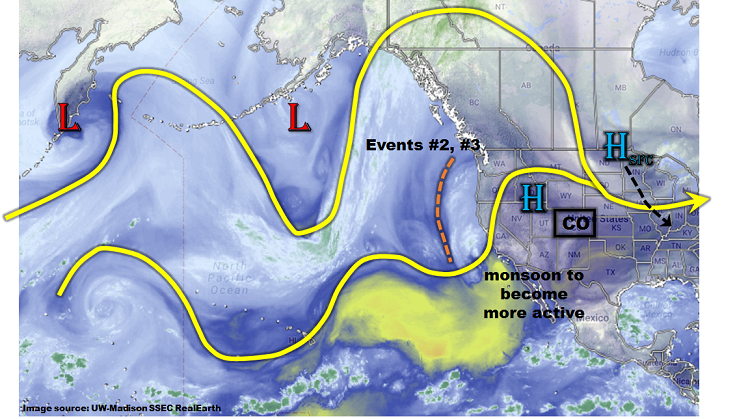
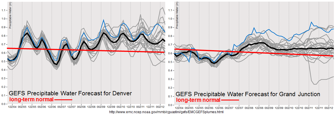
In all, we foresee three precipitation events for this Outlook, though there will be relatively little demarcation between each event. Event #1 will be rainfall activity associated with the frontal passage, expected to last through Wednesday with No Apparent Flood Threat. Event #2 will be the approach of the eastern Pacific trough that may provide isolated heavy rainfall east of the Continental Divide as well as across Southwest Colorado. Event #3 will be due to the presence of residual moisture that will provide scattered diurnal storms across the High Country, with a possible eastward extension into the Plains. In all, the forecast Precipitable Water (PW) plumes, below, show that moisture at Denver and Grand Junction is expected to stay above to well-above climatological levels for early September. In turn, this suggests above normal precipitation chances, though confidence in heavy rainfall is weaker.
Below we describe each of the three identified precipitation events in more detail.
Event #1: Tuesday (9/5) and Wednesday (9/6)
No Apparent Flood Threat as front passage leaves residual moisture in southern and southwestern areas.
Daily rounds of isolated to widely scattered showers and thunderstorms are expected in the Southeast Mountains and San Juans on Tuesday and Wednesday. Instability will be limited and moisture will remain marginal so daily rainfall amounts of up to 0.5 inches are expected. The best coverage will be in the San Juans. Elsewhere, northeast Colorado will see a tremendous cool-down on Tuesday, followed by a rapid warm-up on Wednesday. Flooding is not expected with this event.
Event #2: Thursday (9/7) through Saturday (9/9)
Low-end Elevated Flood Threat for mainly isolated heavy rainfall and flash flooding
As the trough approaches Colorado, an increase in precipitation chances is expected statewide. Precipitable water is expected to increase to 0.8 – 1.0 inch out west and up to 1.2 inches out east. At a minimum, daily upslope flow is expected to produce scattered to numerous showers and thunderstorms mainly in central and southern Colorado. However, some storms could make it out onto the eastern Plains given even slight upper-level support. Maximum rainfall rates are expected to remain right at flood threat thresholds: roughly 1 inch per hour out west and up to 1.7 inches per hour out east. Thus, an isolated flash flooding risk will be possible, with mud flows and debris slides also possible over the Foothills. The Southeast Mountains’ fire burn areas will be of particular concern given that precipitation chances will be high in this region.

Event #3: Sunday (9/10) through Tuesday (9/12)
No Apparent Flood Threat as residual moisture and trough position in question
A weak ridge is expected to re-establish following Event #2. However, residual moisture is expected to remain implying isolated to scattered shower activity in the higher terrain. At this time, it does not appear that heavy rainfall will occur and precipitation rates are expected to remain below 0.5 inches per hour out west and 0.75 inches per hour east. It is possible that this event will be upgraded given what transpires farther southwest with the monsoon.