Issue Date: Monday, August 28, 2017
Issue Time: 2PM MDT
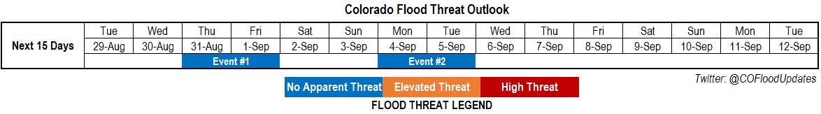
Valid Dates: 8/29-9/12
Calmer weather has settled into Colorado, followed a prolonged, very active stretch during most of July and early August. Daily rounds of isolated to widely scattered showers and weak thunderstorms have still persisted especially in climatologically favored regions of the central and southern part of the state. However, heavy rainfall has been isolated and brief, and flooding has not been an issue.
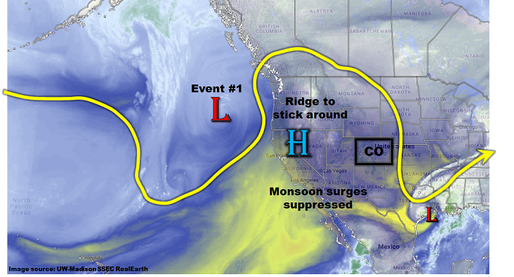
As shown in the water vapor image, below, relatively quiet weather is expected through the entirety of this 15-day Outlook. A seasonably strong ridge is currently positioned over the Great Basin. This is maintaining dry and well above normal temperatures west of the Continental Divide and a few isolated storms in the picture across eastern Colorado. Off the west coast, a shortwave embedded in the jet stream is expected to temporarily flatten the ridge and support an increase in precipitation coverage across mainly eastern Colorado; this is identified as Event #1.
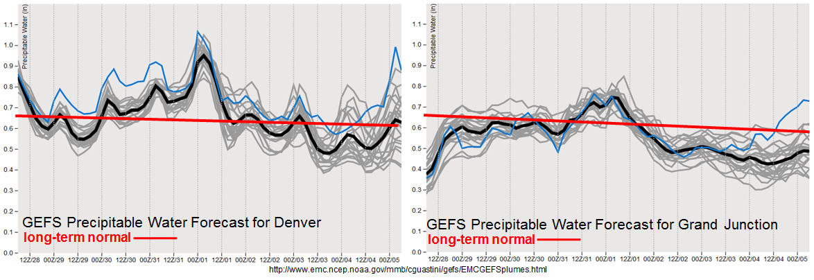
As shown in the forecasted Precipitation Water plumes, below, the shortwave passage will cause a brief increase in moisture, especially east of the Continental Divide. Short-term heavy rainfall will be possible, along with isolated severe weather in far eastern Colorado. However, rainfall rates are expected to stay just below flood threat level. After a rapid warm up following Event #1, a strong high pressure is expected to move south out of Canada, driving a fall cool front across mainly eastern Colorado. This is currently identified as Event #2. Although precipitation coverage and intensity are expected to increase, heavy rainfall is expected to be limited, and flooding is not expected at this time.
Finally, it is interesting to note that the lull in monsoon moisture continues across the western slope. Although monsoon surges can occur well into September, chances of heavy rainfall drop off drastically starting in early September. Climatologically speaking, it is much too soon to suggest that the monsoon may be finished for western Colorado, but when we look back several weeks from now, this could end up being the truth.
Below we describe each of the two identified precipitation events in more detail.
Event #1: Thursday (8/31) and Friday (9/1)
No Anticipated Flood Threat as shortwave treks across Colorado; upgrade possible
A shortwave will move across Colorado on Thursday and Friday, temporarily increasing rainfall coverage and intensity. Highest coverage will be east of the Continental Divide. Afternoon and evening showers and weak thunderstorms are expected across the High Country of central and southern Colorado. With the upper-level support, scattered thunderstorms are also expected across the eastern plains. A severe threat, mainly for large hail, will accompany the isolated heavy rainfall. Max 1-hour rainfall up to 1 inch (west) and 1.5 inch (east) can be expected. These rates are just below flood threat intensity. However, if slightly more moisture return occurs, an elevated threat could occur on Thursday.
By Friday, precipitation chances will scoot further south towards the Southeast Mountains and plains. However, moisture levels are expected to drop and rainfall rates should be limited to 1 inch an hour or less. Flooding is not expected at this time.

Event #2: Monday (9/4) through Tuesday (9/5)
No Apparent Flood Threat as front passage likely, but moisture appears to low for heavy rainfall
Guidance is in reasonable agreement today regarding the passage of a strong fall-like cool front starting on Monday, 9/4. An increase in rainfall coverage is expected mainly east of the Continental Divide. However, moisture return appears to be limited, and it is not clear if there will be enough instability to even generate thunderstorms. At this time, precipitation amounts in the 0.25 – 0.5 inch range are foreseen, and thus a precipitation map is not provided.