FTO 05-07-2018: Another Spring Soaking Expected by the Week’s End

Issue Date: Monday, May 7, 2018
Issue Time: 2PM MDT
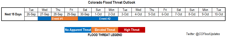
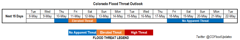
Valid Dates: 5/8 – 5/22

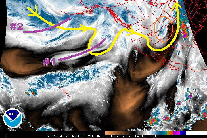
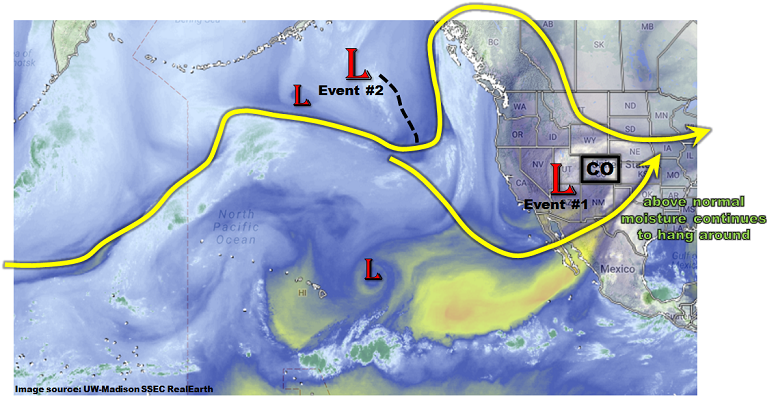
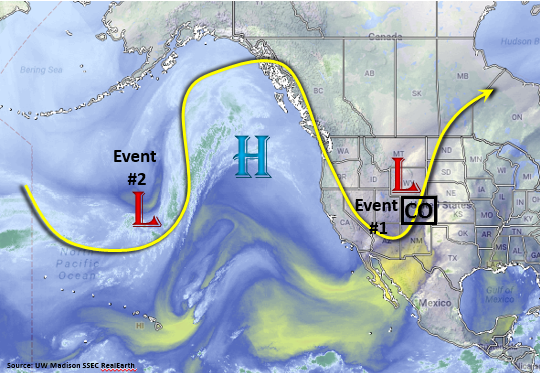
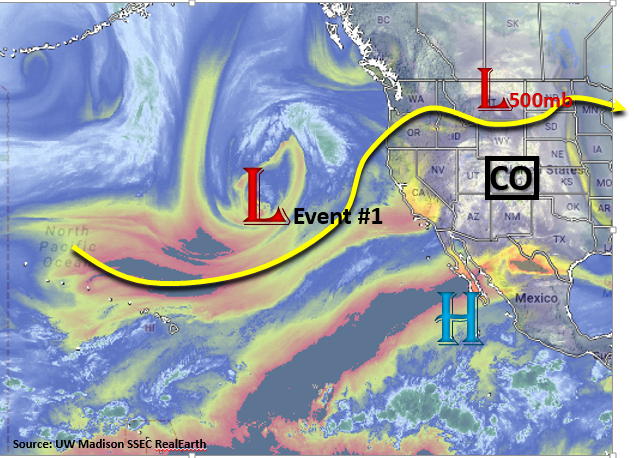
The upper level disturbance that is currently affecting the state can be seen over Montana in the water vapor imagery below. This will continue move through the state this afternoon and beginning tomorrow, the visible ridge over the west coast will begin to build. This will bring warm and dry weather to the state the next couple of days before arrival of the next system. Event #1 is associated with the large scale disturbance over the Pacific that will continue to march eastward the next couple of days. Currently, the trough is forecasted to dig south into Utah and Arizona and produce an unsettled weather pattern over the state beginning Thursday. After this trough moves out of the state Sunday, a quieter, more zonal and ridging pattern sets up for the remainder of next week. Models are hinting at another large scale disturbance (Event #2) moving through the area at the end of this Outlook; however, it is essential to stress this may change. Currently, the rainfall for Event #2 is projected to fall over the higher terrains and eastern plains.

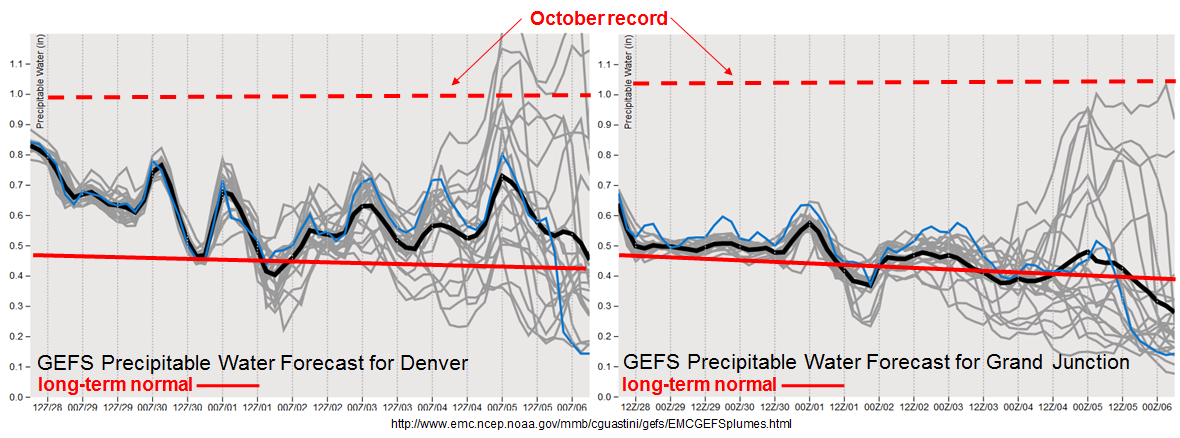
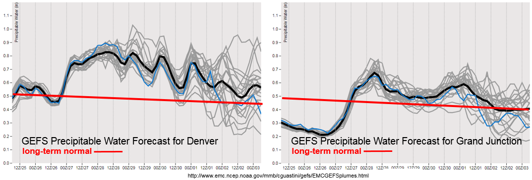
Later this week, moisture levels will begin to rise with the approaching trough. By Thursday, an increase in moisture, paired with shortwaves, will help trigger isolated thunderstorms over the higher terrain and eastern plains. By Friday afternoon, PW is expected to be in the 0.6-0.7 inch range west of the Continental Divide, and east of the Divide, PW values will increase to 0.8 inches over northern Urban Corridor and Northeast Plains. The upper level dynamics and increased moisture will produce showers nearly statewide, but the greatest rainfall totals will be confined to the northern high terrains and Northeast Plains. The best chances of heavy rainfall and flooding will occur from Friday afternoon into Saturday.  Below we describe the two identified precipitation events in more detail.

Event #1: Thursday (5/10) – Sunday (5/13)

Elevated/No Apparent Threat as increased moisture pairs with a trough for a rain-filled weekend

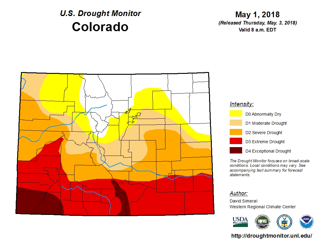
Moisture returns to northeast Colorado and the far eastern plains later this week. This event will begin with isolated thunderstorms over the high terrains and Northeast Plains Thursday. Friday into Saturday, expect showers to increase in coverage and intensity. The best chances for heavy rainfall totals will be over the northern high terrains and Northeast Plains. 1-hr rain rates will generally be around or under 0.1 inches with stronger storms producing rates up to 0.25 inches/hour. West of the Continental Divide, higher rainfall totals will be confined to the mountains, though more limited rainfall should occur in the valleys. Snow will be likely at elevations above 9,500 feet with the snowline decreasing in elevation Saturday night. Similar to the last storm, this will provide a much needed soaking for the ground due to low snowpack this last winter. Unfortunately, the event won’t do much to alleviate the growing drought over southern Colorado.


Legend

Event #2: Friday (5/18) – Monday (5/21)

No Apparent Threat as another trough approaches the state from the west

The ridging pattern begins to break down again towards the end of next week brining more rainfall to the state. Currently the GFS is forecasting a trough moving into the Great Basin from the west coast. Moisture appears to only be present east of the Continental Divide, which is normal for this time of year. Confidence is low at this time, but the rainfall will likely affect the Front Range, Southeast Mountains and eastern plains. Stay tuned to the future FTOs as details will likely change.

Legend

FTO 05-03-2018: Two Events on the Horizon to Welcome Back the FTO

Issue Date: 5/3/2018
Issue Time: 11:00 AM

We are back with the first edition of the FTO for the 2018 season. It is our pleasure to serve you again this season.
Before jumping into the discussion of this FTO period, I wanted to discuss briefly the Drought Monitor for the state of Colorado, released this morning (05-03-2018). As you can see, drought has taken hold across a chunk of Colorado, with extreme/exceptional drought blanketing southern Colorado. This will be important to keep an eye on as the summer progresses, both as a fire issue and as a potential limiting factor on flash flood potential. This recent storm over the last couple of days has helped, but unfortunately most of the rain fell to the north of the extreme drought region.

Now, let’s get to the FTO forecast. First, in the water vapor imagery below, I have highlighted a few features of note. The orange-circled area is the low-pressure system currently exiting the state, which will leave behind nothing more than enough residual moisture for a couple isolated showers/thunderstorms early in the FTO period. Thus, this will receive no special treatment as an event, and our eyes can turn to Event #1. Event #1 is an approaching upper-level trough denoted with a purple line and “#1” in the water vapor image. Event #1 will begin to impact Colorado on Sunday, May 6th, as the disturbance works with surface high pressure over the Plains to usher in moisture from the Gulf of Mexico, producing scattered showers/thunderstorms, mainly east of the Continental Divide and across the eastern Plains. Monday (May 7th) will see an increase in showers/thunderstorms over the mountains with continued activity over the Plains, as well, before the disturbance moves east of the state by Tuesday morning.

After Event #1, transient high pressure will result in drier conditions for Tuesday and Wednesday, before Event #2 comes knocking on Thursday, May 10th. Event #2 is marked by a quickly moving shortwave trough, ejected from the larger low-pressure area that will remain centered over the Gulf of Alaska. Event #2 looks like a classic eastern plains severe weather event for Thursday, May 10th, with a few thunderstorms over the mountains, as well. By Friday, the disturbance is east of the state and Event #2 ends as quickly as it began. Then, the focus will be on the low-pressure area centered over the Gulf of Alaska.

At the current time, it appears that the low-pressure will remain stationary for a couple of days, as ridging builds over the southwestern US, which will allow for Colorado to dry out Friday-Monday (11th-13th). Uncertainty, owing to the spring time transient pattern, precludes me from designating this as an official event, however a mention is necessary. Tuesday through Thursday (May 15-17) looks to be the most likely time frame of impacts for Colorado. An update on this will come in Monday’s edition of the FTO; we will continue to monitor the area.

Event #1: Sunday (05-06-2018) through Tuesday morning (05-08-2018)

No Apparent Threat as Best Moisture Stays Across the Plains

Event #1 will be the result of a disturbance aloft working with surface high pressure over the Plains to usher in moisture from the Gulf of Mexico. Sunday will feature scattered showers/thunderstorms over the eastern Plains and a few over the high country, mainly east of the Continental Divide. Monday will be the most active day of the event, with plenty of moisture and instability to produce scattered showers/thunderstorms across much of the state. Over lower elevations of eastern Colorado, a few severe storms will be possible, as the early-May sunshine heats the surface and results in pockets of stronger instability. The disturbance will then move east of the state by Tuesday morning.

Legend

Event #2: Thursday (05-10-2018) through Friday morning (05-11-2018)

No Apparent Threat as Quick-Hitting Disturbance Marches Through

Event #2 appears to be a classic eastern Colorado severe setup, with isolated-to-scattered thunderstorms over the mountains and scattered strong-to-severe thunderstorms over the plains. Strong westerly winds in the cloud layer will keep storms moving towards the east at a good pace, so no flood threat is apparent at this time. However, this event should result in beneficial rain for eastern Colorado, outlined by the precipitation map below.

Legend

FTO 09-28-2017: Prospects Of Heavy Rainfall Continue To Hang Around, Later Than Normal

Issue Date: Thursday, September 28, 2017
Issue Time: 1PM MDT
Valid Dates: 9/29-10/13

Note: This is the last Flood Threat Outlook for the 2017 season. We will be back next spring, starting May 1.

After a fairly quiet start to September, a sudden recent change in the weather pattern has now put most of eastern Colorado in the above normal precipitation category for the month (see below). In fact, some locations in the Southeast Plains have accumulated 2-3 times their normal precipitation. The vast majority of the precipitation has fallen in relatively orderly fashion and flooding has largely been avoided (just like in the summer, thankfully). West of the Continental Divide, the San Juans have fared well with close to normal amounts, but other locations are below normal for September precipitation.

As shown in the Precipitable Water (PW) composite anomaly for the past 7 days, a large area of above normal moisture has existed in the Central and Northern Great Plains. Anomalies of up to 0.2-0.4 inches (the units below need to be multiplied by 0.04 to arrive at inches) have been found across OK, KS and NE. With even weak return (easterly) flow, pulses of this moisture have found their way into the Arkansas River valley, supporting the widespread generous precipitation.

As shown in the water vapor image, below, we expect a continuation of a very active pattern over the next week or so. The current disturbance, presently located over the Four Corners, will trek slowly NNE within the large scale trough in the subtropical jet stream. It will continue to provide mainly light to perhaps moderate precipitation through this weekend (Event #1). However, overall, this large-scale trough is not expected to move anywhere fast and a new shortwave, currently in the Gulf of Alaska, will help keep the western US in an unsettled weather pattern. This is identified as Event #2.

Unfortunately, the forecast for Event #2 has a very large amount of uncertainty with it. This can be easily seen in the forecasted PW plumes for Denver and Grand Junction, below. At both locations, not the sudden increase in spread beginning on Wednesday, 10/4. This arises due to uncertainty in the southern extent of the new trough, as well as how long of a return flow will exist from the Gulf of Mexico. In short, the range of PW forecasts is from well below normal to near October record levels approaching or exceeding 1 inch at both locations! Due to the continuation of much above normal PW in the Central Plains, a brief Elevated threat is warranted for eastern Colorado during Event #2. However, it is essential to stress that this may change. However, if a flood threat appears, we will be doing special Flood Threat Bulletin(s) as warranted.

Below we describe the two identified precipitation events in more detail.

Event #1: Friday (9/29) through Sunday (10/1)

No Apparent Flood Threat as precipitation coverage gradually steps down from Friday through Sunday

With enough moisture available, along with favorable dynamics, we expect pulses of rain and snow shower activity to continue through Sunday. The highest coverage will be Friday, favoring the upslope regions of the San Juans and Northern Mountains. Activity will subside by Saturday, though isolated to scattered showers will still be possible mainly over the higher terrain. By Sunday, there is a chance of enhanced precipitation coverage in far eastern Colorado as a warm sector is expected to setup here. At this time, the highest instability and low-level moisture is expected to remain in KS. Thus, while hourly rainfall rates up to 0.8 inches could occur along the KS border, this would not be enough to cause flooding concerns.

Legend

Event #2: Tuesday (10/3) through Friday (10/6)

Brief Elevated Flood Threat as another large system approaches Colorado; widespread rain/snow likely

After only a short lull following Event #2, another shortwave is expected to reinvigorate the western US trough, leading to statewide unsettled weather beginning on Tuesday. Widespread rain and snow showers are expected over the higher terrain mainly west of the Continental Divide on Tuesday, spreading eastward on Wednesday. Total precipitation (rain and snow) of up to 1.5 inches could occur in the favor upslope regions of the San Juans, Central Mountains and Northern Mountains. The biggest uncertainty at this time is for eastern Colorado. Some guidance is suggesting that return moisture advection will be strong enough to bring PW over 1 inch east of the Continental Divide. This will be supported by a relatively strong low-level surface cyclone expected to develop in eastern Colorado. Moderately strong instability, to the tune of Convective Available Potential Energy exceeding 750 J/kg, is possible in the eastern third of the state. This is where the highest risk of heavy rainfall and flooding will occur on Wednesday. At this time, the chance of 1-hr rainfall rates exceeding 1.5 inches and 3-hour rates exceeding 2.5 inches is possible, though not yet probable. If this materializes, we will be providing a special Flood Threat Bulletin(s).

After Wednesday, a gradual decrease in moisture is expected statewide. Precipitation coverage will accordingly decrease though scattered rain and snow showers will be possible, especially over northern Colorado, through Friday.

Legend

FTO 09-25-2017: Unsettled Weather Pattern Continues with a Cutoff Low Over the Desert Southwest

Issue Date: Monday, September 25, 2017
Issue Time: 3PM MDT
Valid Dates: 9/26 – 10/10

The slow moving, high-amplitude weather pattern that has influenced Colorado’s weather since late last week will continue to impact the state for the first portion of this forecast period. Today and tonight the first trough, that has driven the unsettled weather pattern over Colorado since late last week, will finally start to lift to the northeast. Another trough begins to dig south Tuesday and a closed Low forms over AZ/UT by Wednesday morning. This closed Low spins and remains nearly stationary over Utah until Thursday afternoon when it begins to lift northeast (Event #1). By Saturday morning, more westerly flow will replace the southwesterly flow aloft bringing warmer temperatures and should confine showers to the high terrains. A weak trough forms over the Pacific Northwest Saturday, and by Sunday afternoon/evening the disturbance makes its way into Colorado for Event #2. By mid-week, more zonal flow is expected, which will decrease the chances for heavy rainfall.

Currently average to below average Precipitable Water (PW) is present in Denver and Grand Junction. Beginning Tuesday, PW is forecasted to increase rapidly for locations east and west of the Continental Divide. The upturn in PW is expected to last through Sunday morning. This intensification of low level moisture occurs due to the counterclockwise rotation of the surface Low over the desert southwest. To the east of the Low (Colorado) there will be an increase in south/southeast surface winds, which will draw in moisture in from the Gulf of Mexico. The GEFS has PW values over 1 inch on Thursday over the Southeast Plains, which is 30-40% above average for this time of year. The uptick in moisture occurs in tandem with multiple shortwaves from the cutoff low. This will create an Elevated Flood Threat for Thursday and Friday. Although Event #2 occurs directly after Event #1, the atmosphere is expected to dry out quite a bit. This decreases the chances for heavy rainfall, and at this time there is No Apparent Flood Threat.

Below we describe the identified precipitation event in more detail.

Event #1: Wednesday (9/27) – Saturday (9/30)

Elevated Flood Threat with highest accumulations expected over the southern mountains and eastern plains

The high amplitude system over the western US continues to drop multiple troughs to our west. The next trough is expected to dig south Tuesday, and a cutoff Low forms over the desert southwest by Wednesday morning. This pattern is known for producing heavy rain in southern Colorado and along the Front Range. As is expected with a closed Low system, little to no movement occurs as it draws in moisture on its east side from the Gulf. Moisture is expected to increase rapidly both east and west of the Continental Divide starting Tuesday and reach its maximum Wednesday and Thursday. At the same time, multiple shortwaves and an upper level jet stream over the state are expected to increase lift. Wednesday, showers are expected to be strongest over the Central and San Juan Mountains. By Thursday showers and thunderstorms will spread to the east over the Southeast Mountains, Palmer Ridge, Raton Ridge and Southeast Plains. With high PW values, especially over the Southeast Plains, there is an Elevated Flood Threat for Thursday and Friday. Severe thunderstorms may be possible both days over the Southeast Plains should instability be able to pair with the available shear. The Low lifts to the north/northwest overnight Friday. Showers are likely again Saturday with residual moisture in the atmosphere, but accumulations will be confined to the higher terrains.

Legend

Event #2: Sunday (10/1) – Monday (10/2)

No Apparent Flood Threat as an upper trough develops over Montana and moves into the state

A second, weaker trough then develops Saturday following Event #1 over the Pacific Northwest. By Sunday afternoon, the trough moves into Colorado with the jet stream positioned over the northwest corner. Increased shortwave activity and upper level support will bring another round of showers to the state Sunday afternoon and Monday. Drier air works its way in from the desert southwest, so precipitation should be confined east of the Continental Divide. Flood is not expected at this time, but please check back to Thursday’s FTO to see if a special FTB will issued Monday.

Legend