Issue Date: Monday, September 25, 2017
Issue Time: 3PM MDT
Valid Dates: 9/26 – 10/10

The slow moving, high-amplitude weather pattern that has influenced Colorado’s weather since late last week will continue to impact the state for the first portion of this forecast period. Today and tonight the first trough, that has driven the unsettled weather pattern over Colorado since late last week, will finally start to lift to the northeast. Another trough begins to dig south Tuesday and a closed Low forms over AZ/UT by Wednesday morning. This closed Low spins and remains nearly stationary over Utah until Thursday afternoon when it begins to lift northeast (Event #1). By Saturday morning, more westerly flow will replace the southwesterly flow aloft bringing warmer temperatures and should confine showers to the high terrains. A weak trough forms over the Pacific Northwest Saturday, and by Sunday afternoon/evening the disturbance makes its way into Colorado for Event #2. By mid-week, more zonal flow is expected, which will decrease the chances for heavy rainfall.
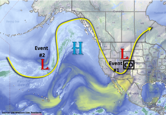
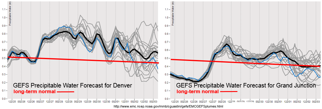
Currently average to below average Precipitable Water (PW) is present in Denver and Grand Junction. Beginning Tuesday, PW is forecasted to increase rapidly for locations east and west of the Continental Divide. The upturn in PW is expected to last through Sunday morning. This intensification of low level moisture occurs due to the counterclockwise rotation of the surface Low over the desert southwest. To the east of the Low (Colorado) there will be an increase in south/southeast surface winds, which will draw in moisture in from the Gulf of Mexico. The GEFS has PW values over 1 inch on Thursday over the Southeast Plains, which is 30-40% above average for this time of year. The uptick in moisture occurs in tandem with multiple shortwaves from the cutoff low. This will create an Elevated Flood Threat for Thursday and Friday. Although Event #2 occurs directly after Event #1, the atmosphere is expected to dry out quite a bit. This decreases the chances for heavy rainfall, and at this time there is No Apparent Flood Threat.
Below we describe the identified precipitation event in more detail.
Event #1: Wednesday (9/27) – Saturday (9/30)
Elevated Flood Threat with highest accumulations expected over the southern mountains and eastern plains
The high amplitude system over the western US continues to drop multiple troughs to our west. The next trough is expected to dig south Tuesday, and a cutoff Low forms over the desert southwest by Wednesday morning. This pattern is known for producing heavy rain in southern Colorado and along the Front Range. As is expected with a closed Low system, little to no movement occurs as it draws in moisture on its east side from the Gulf. Moisture is expected to increase rapidly both east and west of the Continental Divide starting Tuesday and reach its maximum Wednesday and Thursday. At the same time, multiple shortwaves and an upper level jet stream over the state are expected to increase lift. Wednesday, showers are expected to be strongest over the Central and San Juan Mountains. By Thursday showers and thunderstorms will spread to the east over the Southeast Mountains, Palmer Ridge, Raton Ridge and Southeast Plains. With high PW values, especially over the Southeast Plains, there is an Elevated Flood Threat for Thursday and Friday. Severe thunderstorms may be possible both days over the Southeast Plains should instability be able to pair with the available shear. The Low lifts to the north/northwest overnight Friday. Showers are likely again Saturday with residual moisture in the atmosphere, but accumulations will be confined to the higher terrains.

Event #2: Sunday (10/1) – Monday (10/2)
No Apparent Flood Threat as an upper trough develops over Montana and moves into the state
A second, weaker trough then develops Saturday following Event #1 over the Pacific Northwest. By Sunday afternoon, the trough moves into Colorado with the jet stream positioned over the northwest corner. Increased shortwave activity and upper level support will bring another round of showers to the state Sunday afternoon and Monday. Drier air works its way in from the desert southwest, so precipitation should be confined east of the Continental Divide. Flood is not expected at this time, but please check back to Thursday’s FTO to see if a special FTB will issued Monday.