Issue Date: Thursday, September 28, 2017
Issue Time: 1PM MDT
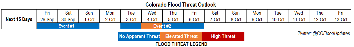
Valid Dates: 9/29-10/13
Note: This is the last Flood Threat Outlook for the 2017 season. We will be back next spring, starting May 1.
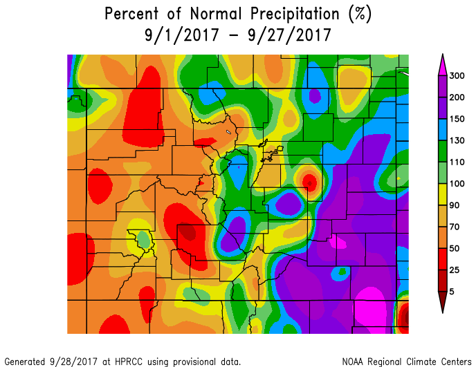
After a fairly quiet start to September, a sudden recent change in the weather pattern has now put most of eastern Colorado in the above normal precipitation category for the month (see below). In fact, some locations in the Southeast Plains have accumulated 2-3 times their normal precipitation. The vast majority of the precipitation has fallen in relatively orderly fashion and flooding has largely been avoided (just like in the summer, thankfully). West of the Continental Divide, the San Juans have fared well with close to normal amounts, but other locations are below normal for September precipitation.
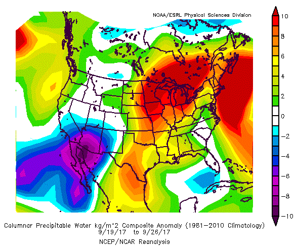
As shown in the Precipitable Water (PW) composite anomaly for the past 7 days, a large area of above normal moisture has existed in the Central and Northern Great Plains. Anomalies of up to 0.2-0.4 inches (the units below need to be multiplied by 0.04 to arrive at inches) have been found across OK, KS and NE. With even weak return (easterly) flow, pulses of this moisture have found their way into the Arkansas River valley, supporting the widespread generous precipitation.
As shown in the water vapor image, below, we expect a continuation of a very active pattern over the next week or so. The current disturbance, presently located over the Four Corners, will trek slowly NNE within the large scale trough in the subtropical jet stream. It will continue to provide mainly light to perhaps moderate precipitation through this weekend (Event #1). However, overall, this large-scale trough is not expected to move anywhere fast and a new shortwave, currently in the Gulf of Alaska, will help keep the western US in an unsettled weather pattern. This is identified as Event #2.
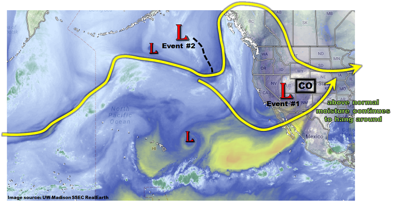
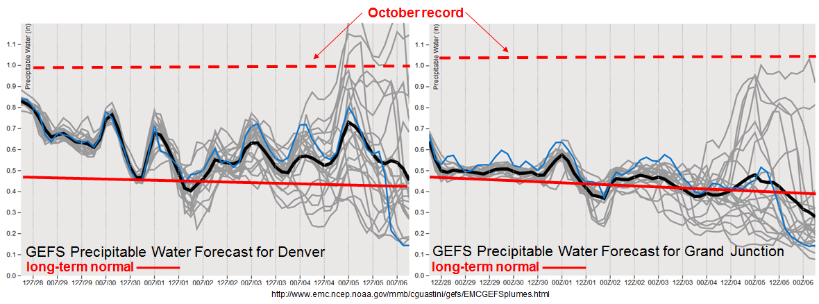
Unfortunately, the forecast for Event #2 has a very large amount of uncertainty with it. This can be easily seen in the forecasted PW plumes for Denver and Grand Junction, below. At both locations, not the sudden increase in spread beginning on Wednesday, 10/4. This arises due to uncertainty in the southern extent of the new trough, as well as how long of a return flow will exist from the Gulf of Mexico. In short, the range of PW forecasts is from well below normal to near October record levels approaching or exceeding 1 inch at both locations! Due to the continuation of much above normal PW in the Central Plains, a brief Elevated threat is warranted for eastern Colorado during Event #2. However, it is essential to stress that this may change. However, if a flood threat appears, we will be doing special Flood Threat Bulletin(s) as warranted.
Below we describe the two identified precipitation events in more detail.
Event #1: Friday (9/29) through Sunday (10/1)
No Apparent Flood Threat as precipitation coverage gradually steps down from Friday through Sunday
With enough moisture available, along with favorable dynamics, we expect pulses of rain and snow shower activity to continue through Sunday. The highest coverage will be Friday, favoring the upslope regions of the San Juans and Northern Mountains. Activity will subside by Saturday, though isolated to scattered showers will still be possible mainly over the higher terrain. By Sunday, there is a chance of enhanced precipitation coverage in far eastern Colorado as a warm sector is expected to setup here. At this time, the highest instability and low-level moisture is expected to remain in KS. Thus, while hourly rainfall rates up to 0.8 inches could occur along the KS border, this would not be enough to cause flooding concerns.

Event #2: Tuesday (10/3) through Friday (10/6)
Brief Elevated Flood Threat as another large system approaches Colorado; widespread rain/snow likely
After only a short lull following Event #2, another shortwave is expected to reinvigorate the western US trough, leading to statewide unsettled weather beginning on Tuesday. Widespread rain and snow showers are expected over the higher terrain mainly west of the Continental Divide on Tuesday, spreading eastward on Wednesday. Total precipitation (rain and snow) of up to 1.5 inches could occur in the favor upslope regions of the San Juans, Central Mountains and Northern Mountains. The biggest uncertainty at this time is for eastern Colorado. Some guidance is suggesting that return moisture advection will be strong enough to bring PW over 1 inch east of the Continental Divide. This will be supported by a relatively strong low-level surface cyclone expected to develop in eastern Colorado. Moderately strong instability, to the tune of Convective Available Potential Energy exceeding 750 J/kg, is possible in the eastern third of the state. This is where the highest risk of heavy rainfall and flooding will occur on Wednesday. At this time, the chance of 1-hr rainfall rates exceeding 1.5 inches and 3-hour rates exceeding 2.5 inches is possible, though not yet probable. If this materializes, we will be providing a special Flood Threat Bulletin(s).
After Wednesday, a gradual decrease in moisture is expected statewide. Precipitation coverage will accordingly decrease though scattered rain and snow showers will be possible, especially over northern Colorado, through Friday.