Issue Date: 5/3/2018
Issue Time: 11:00 AM

We are back with the first edition of the FTO for the 2018 season. It is our pleasure to serve you again this season.
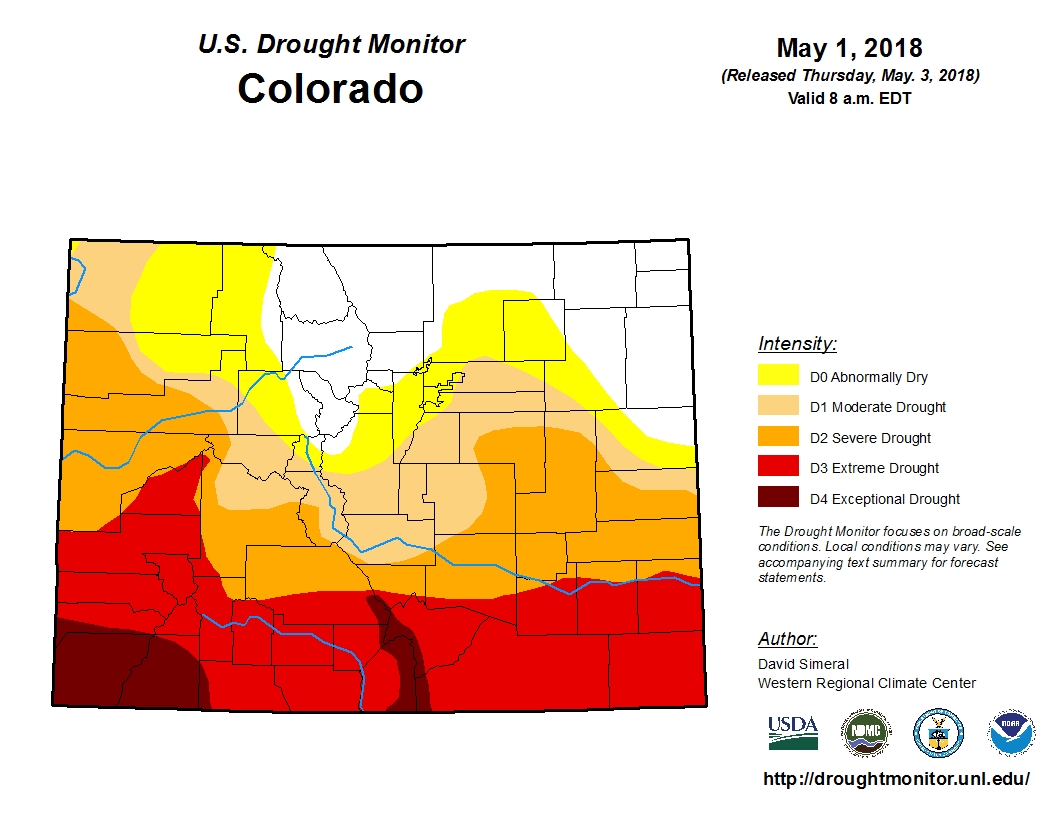
Before jumping into the discussion of this FTO period, I wanted to discuss briefly the Drought Monitor for the state of Colorado, released this morning (05-03-2018). As you can see, drought has taken hold across a chunk of Colorado, with extreme/exceptional drought blanketing southern Colorado. This will be important to keep an eye on as the summer progresses, both as a fire issue and as a potential limiting factor on flash flood potential. This recent storm over the last couple of days has helped, but unfortunately most of the rain fell to the north of the extreme drought region.
Now, let’s get to the FTO forecast. First, in the water vapor imagery below, I have highlighted a few features of note. The orange-circled area is the low-pressure system currently exiting the state, which will leave behind nothing more than enough residual moisture for a couple isolated showers/thunderstorms early in the FTO period. Thus, this will receive no special treatment as an event, and our eyes can turn to Event #1. Event #1 is an approaching upper-level trough denoted with a purple line and “#1” in the water vapor image. Event #1 will begin to impact Colorado on Sunday, May 6th, as the disturbance works with surface high pressure over the Plains to usher in moisture from the Gulf of Mexico, producing scattered showers/thunderstorms, mainly east of the Continental Divide and across the eastern Plains. Monday (May 7th) will see an increase in showers/thunderstorms over the mountains with continued activity over the Plains, as well, before the disturbance moves east of the state by Tuesday morning.
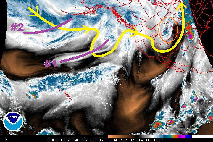
After Event #1, transient high pressure will result in drier conditions for Tuesday and Wednesday, before Event #2 comes knocking on Thursday, May 10th. Event #2 is marked by a quickly moving shortwave trough, ejected from the larger low-pressure area that will remain centered over the Gulf of Alaska. Event #2 looks like a classic eastern plains severe weather event for Thursday, May 10th, with a few thunderstorms over the mountains, as well. By Friday, the disturbance is east of the state and Event #2 ends as quickly as it began. Then, the focus will be on the low-pressure area centered over the Gulf of Alaska.
At the current time, it appears that the low-pressure will remain stationary for a couple of days, as ridging builds over the southwestern US, which will allow for Colorado to dry out Friday-Monday (11th-13th). Uncertainty, owing to the spring time transient pattern, precludes me from designating this as an official event, however a mention is necessary. Tuesday through Thursday (May 15-17) looks to be the most likely time frame of impacts for Colorado. An update on this will come in Monday’s edition of the FTO; we will continue to monitor the area.
Event #1: Sunday (05-06-2018) through Tuesday morning (05-08-2018)
No Apparent Threat as Best Moisture Stays Across the Plains
Event #1 will be the result of a disturbance aloft working with surface high pressure over the Plains to usher in moisture from the Gulf of Mexico. Sunday will feature scattered showers/thunderstorms over the eastern Plains and a few over the high country, mainly east of the Continental Divide. Monday will be the most active day of the event, with plenty of moisture and instability to produce scattered showers/thunderstorms across much of the state. Over lower elevations of eastern Colorado, a few severe storms will be possible, as the early-May sunshine heats the surface and results in pockets of stronger instability. The disturbance will then move east of the state by Tuesday morning.

Event #2: Thursday (05-10-2018) through Friday morning (05-11-2018)
No Apparent Threat as Quick-Hitting Disturbance Marches Through
Event #2 appears to be a classic eastern Colorado severe setup, with isolated-to-scattered thunderstorms over the mountains and scattered strong-to-severe thunderstorms over the plains. Strong westerly winds in the cloud layer will keep storms moving towards the east at a good pace, so no flood threat is apparent at this time. However, this event should result in beneficial rain for eastern Colorado, outlined by the precipitation map below.