FTO 06-04-2018: Dry and Hot to Start this Week with an Uptick of Showers by the Weekend

Issue Date: Monday, June 4th, 2018
Issue Time: 1:15PM MDT
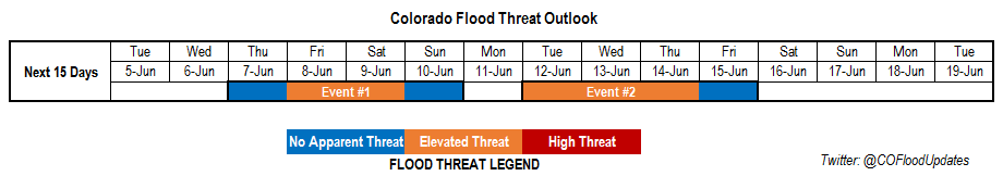
Valid Dates: 6/5 – 6/19

The start of this 15-day flood outlook will be dominated by a ridging pattern over Colorado. With the jet stream well to the north of Colorado, this will be a very summer-like period marked with high temperatures through this weekend and limited heavy rainfall potential. The more westerly wind component will pull in very arid air (marked below in orange), which will dry out the atmosphere allowing for only isolated showers to form over the higher terrains each afternoon with the diurnal flow pattern. Low dew points will cause garden variety showers and thunderstorms to produce gusty winds rather than heavy rainfall for the first part of this week. Should these storms stay intact as they reach the eastern plains, some local heavier rainfall will be possible due to higher dew points. Tuesday, some stronger storms could form over the far Southeast Plains along a dry line, but at this time the flooding is not expected as 15-20 knot storm motion will limit rainfall totals under 1.5 inches/hour.

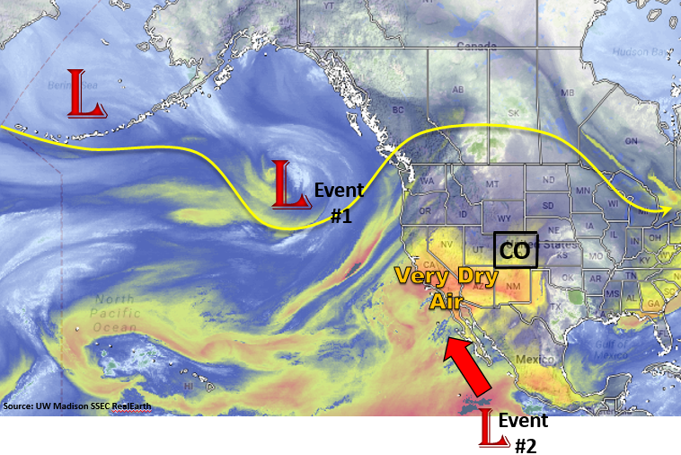
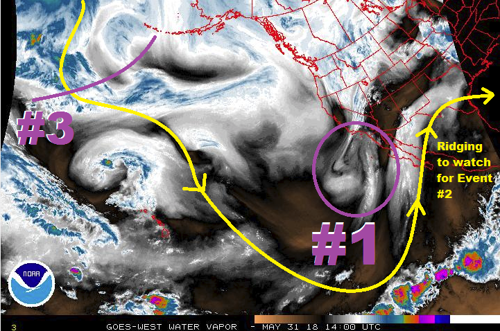
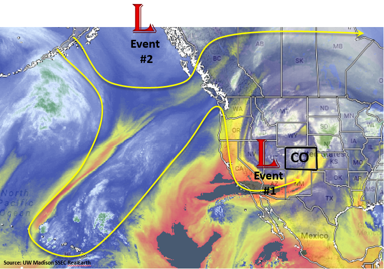
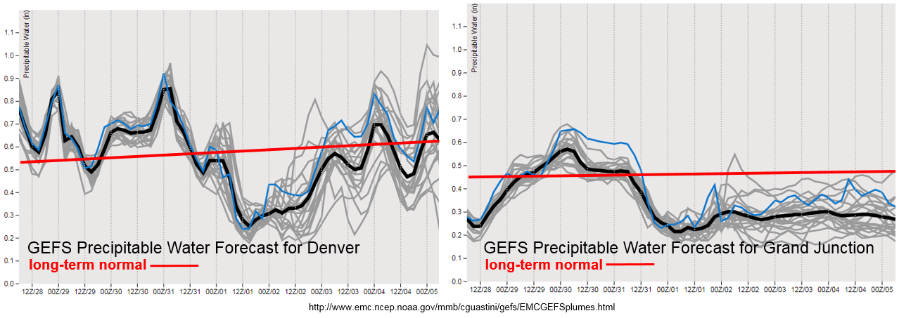
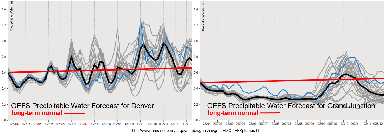
Towards the end of the week the ridge axis shifts to the east of Colorado allowing an uptick in moisture over Denver and Grand Junction (Event #1). This increase can be seen in the GEFS Precipitable Water (PW) plume forecasts for Denver and Grand Junction below. Southwesterly flow will pull in Pacific/Gulf of CA moisture into southwestern/southern Colorado and strong south/southeasterly winds east of the Continental Divide will pull in moisture from the Gulf of Mexico. Thus, there should be an uptick in afternoon thunderstorm coverage and the potential for some heavier rainfall on Saturday into Sunday with slower storm motion under the ridge. Thunderstorm coverage will still be isolated.

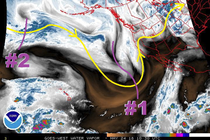
At the start of next week, the GEFS hints at a tropical system moving north along the Baja and into Southern California (Event #2). This tropical system has yet to form, but if it does it would draw in very high PW water values into western and southern Colorado similar to the monsoon pattern. Paired with some shortwave action as the low begins to disperse, this could cause some very heavy rainfall across the San Juan, Central and Southeast Mountains next Tuesday, Wednesday and Thursday. Confidence in this current solution is low, but it will increase closer to this event. So, be sure to check back to Thursday’s FTO. Below we describe each of the two identified precipitation events in more detail.

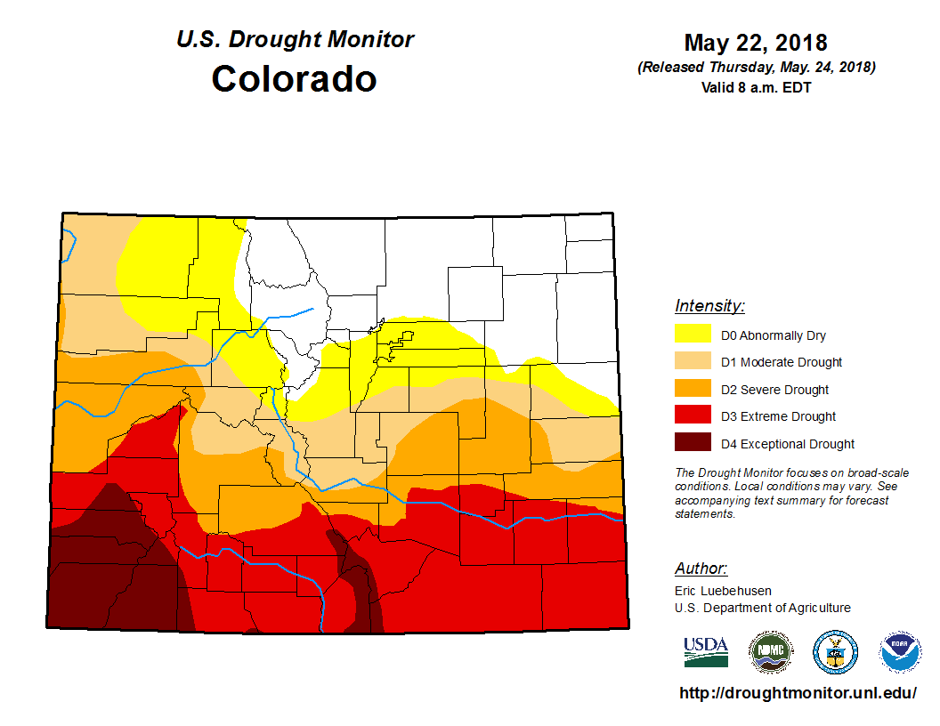
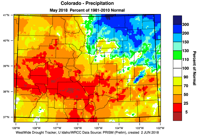
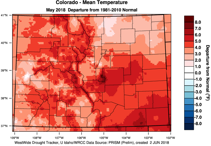
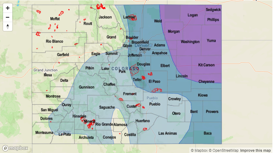
In other news, we have been highlighting the ongoing drought over southern Colorado. Below are the precipitation and temperature anomalies for the month of May from the WRCC. The two days of heavy rainfall in late May over the northeast plains and Urban Corridor helped precipitation values rise to 150-200% above normal. Elsewhere, May was quite dry with isolated portions of the Central Mountains and Grand Valley at less than 5% of normal precipitation. Statewide, temperatures were above well above average. As expected, the warmer temperatures helped dry out the little ground moisture from this winter’s snowpack, which increased fire danger across the the state. We are still looking at critical fire danger across the southern portion of the state this FTO period due to dry fuels and high temperatures in the 90s each day.

Event #1: Thursday (6/7) – Sunday (6/10)

Elevated Flood Threat/No Apparent Threat as the ridge axis slides east and allows an increase in PW for more widespread thunderstorm activity.

The surface high pressure begins to move eastward, which will allow moisture return southwest and eastern CO. With PW values moving closer to 1 inch and light steering flow under the ridge, some isolated heavy rainfall will be likely on Friday and Saturday. The most favored region for thunderstorm activity will be the San Juan Mountains, Southeast Mountains and Northeast Plains; however, the heavier rainfall should be limited to the Northeast Plains. The fire scars over the Southeast Mountains may need to be watched for excessive runoff. Isolated flash flooding, debris slides and mud flows will be possible over the mountains.

Legend

Event #2: Tuesday (6/12) – Friday (6/15)

Elevated Flood Threat/No Apparent Threat as a tropical system brings high PW to the San Juan and Southeast Mountains and strong southeast winds increase PW over the Northeast Plains.

Currently, the GFS is producing a tropical system that moves up the coast of the Baja and into Southern CA. If this transpires, this would supply ample moisture return to southwest and southern Colorado similar to the monsoon pattern. Currently, it is unknown if this system will develop and when the timing of the heaviest rainfall would be. Threats could include flash flooding, debris slides and mud flows over the steeper terrains. Over the plains, field ponding and flooding of low elevation roads are possible. Be sure to check back to Thursday’s FTO for more details as this forecast is likely to change quite a bit.

Legend

FTO 05-31-2018: Slow Start, Unsettled Finish

Issue Date: 5/31/2018
Issue Time: 9:10 AM

This FTO period will get off to a slow start, with a short, one-day event being noted on Sunday, June 3rd, immediately followed by a fairly quiet and hot four-day period. To illustrate the upcoming 15 days, we turn (as usual) to the water vapor imagery to identify any large-scale potential for flooding events. Event #1 is easy to pick out on the water vapor image; it is currently the base of a long wave trough, but will become cut off from the main atmospheric flow, slowly progressing towards Colorado over the next 2-3 days, before finally encroaching on Colorado as a weak shortwave by Sunday, June 3rd. This will provide one day of scattered showers and thunderstorms to the state. Low-level moisture will be a bit on the low side, with “inverted-v” atmospheric sounding profiles precluding the issuance of any flood threat designation for this event. However, this event borders on needing a flood threat designation, and the appearance of more moisture than currently expected will likely result in a flood threat, so be sure to check in on the daily FTB for the most up-to-date forecast.

For Monday, June 4th through Thursday, June 7th, upper-level ridging will build across the south-central United States, placing Colorado under dry, westerly flow aloft and allowing temperatures to rise; it will be an early taste of summer heat before the official start of summer. Some locations across the eastern plains, especially those near the CO/KS border and those in the Arkansas River valley, will see temperatures flirt with 100 degrees. June 8th marks the start of Event #2 (continuing through Tuesday, June 12th), as the ridge axis slides far enough east for southwesterly flow aloft to funnel moisture from eastern Pacific/Gulf of California into Colorado. While this event resembles the monsoon, it is still too early for a good monsoon push. Instead, the dry desert air across the southwestern US will zap a lot of the moisture before it gets to the state, limiting daily thunderstorms to the high-based, garden-variety types. Eastern Colorado, if it is able to grab any moisture from the Great Plains, will be an area to watch for potential flood threats. At this time, no flood threat designation will be given to this time period.

Following quickly on the heels of the previous event, Event #3 will close out the period (Wednesday, June 13th – Friday, June 15th) with 3 days of daily showers/thunderstorms. A shortwave disturbance from the Pacific Northwest will flatten the stubborn ridge that had hung on over the central US for the better part of 8-10 days, providing a trigger the scattered thunderstorm development. At the current time, two big question marks that preclude the issuance of any flood threat designation are, 1) will enough moisture return to the state from the Great Plains/Gulf of Mexico, and 2) will this shortwave disturbance take a path favorable to rainfall in Colorado? The strength of the ridge will play a large role in how this scenario plays out – if the ridge is stronger than expected, this shortwave will stay to the north, leaving Colorado out to dry. With the uncertainty remaining, no flood threat designation will be assigned. Check back with Monday’s FTO for an update on this time period.

Event #1: Sunday (06-03-2018)

No Apparent Threat as Weak Shortwave Briefly Moves through the State

A weak shortwave will become cut off from the main atmospheric flow, slowly meandering its way from southern California towards Colorado. By the time it reaches Colorado, it will pick up enough speed to only bring one day of rainfall to the state. Even so, low-level moisture is expected to be on the low side, reducing the efficiency of rainfall production. Therefore, no flood threat designation is warranted. However, pay close attention to the daily FTB, because if moisture can make a better return to eastern Colorado than expected, a short-term flood threat may be warranted due to stronger thunderstorms and better rainfall efficiency.

<

Legend

Event #2: Friday (06-08-2018) through Tuesday (06-12-2018)

No Apparent Threat from “Monsoon-like” Event

Event #2 is the result of the high-pressure ridge axis shifting far enough to the east to allow for a weak funnel of moisture from the eastern Pacific/Gulf of California. The dry Desert Southwest will zap the moisture from the air before it can get to Colorado, severely hampering rainfall potential. High-based, garden-variety thunderstorms will be the main impact. East of the mountains, close attention will need to be paid to moisture return from the Great Plains/Gulf of Mexico. It’s that time of year where influxes of moisture can be brought on by small-scale surface boundaries, which are beyond the skill of any forecaster/model at this range. Monday’s FTO will provide a needed update on this time period.

Legend

Event #3: Wednesday (06-13-2018) through Friday (06-15-2018)

No Apparent Threat due to High Uncertainty

High uncertainty hovers over this potential event, with the strength of the ridge playing a key role in the resulting weather. A strong ridge will keep the shortwave north of the state, leaving Colorado out to dry with hot temperatures. If the ridge weakens, the shortwave will be able to flatten the ridge and impact Colorado, bringing a period of showers and thunderstorms to the state. Stay tuned.

FTO 05-28-2018: Chance for Afternoon Showers and Thunderstorms to Start the Work Week

Issue Date: Monday, May 28th, 2018
Issue Time: 2:35PM MDT
Valid Dates: 5/29 – 6/12

The repetitive pattern will continue for this next 15-day flood outlook. The jet stream this last few weeks has been more summerlike with the core of the jet residing north over the Midwest. The recurring troughs dropping into the Great Basin has also been rather rhythmic. The water vapor imagery below shows the low that has been controlling the weather the last few days (Event #1) and another trough over Alaska (Event #2). This low associated with Event #1 will begin to lift into an open wave to the northeast this afternoon through tomorrow causing severe weather for northeast Colorado. The second trough will begin to move over the west coast Thursday and drop south over the Great Basin. Before this event reaches Colorado Friday, a ridge will build over the state. While the axis of the ridge is to the west and north of Colorado (drying pattern), residual moisture should be ample enough for isolated afternoon mixes of showers and thunderstorms through Thursday. The tough for Event #2 quickly lifts to the northwest by Saturday morning, and in its wake, plus a weak cool front, a ridge begins to build over the state once again. Temperatures will be above average this week and climb into the low 90s for the lower elevations by this weekend under the developing ridge. The warmer temperatures will continue to melt away the snowpack, so rivers will be running high. However, no major riverine flooding is expected through next weekend.

The GEFS Precipitable Water (PW) plume forecast for Denver and Grand Junction shows this above average moisture through Wednesday, before southwest and westerly flow begin to dry out the lower levels and decrease PW. The moisture through Wednesday should be enough for the diurnal heating pattern to excite a mix of isolated mixed showers and thunderstorms. After Wednesday, southwest flow begin to dry out the state and easterly low level flow will struggle to get PW high enough for heavy rainfall. There is one expectation over the Southeast Plains where severe weather and heavy rainfall could organize Wednesday afternoon. Gusty winds and limited rainfall will be likely elsewhere for storms that form towards the end of this week. Monday and Tuesday of next week a trough to the north will help pull some moisture back into eastern Colorado (potential Event #3), but details for heavy rainfall and severe weather potential over the eastern plains is limited at this time. Please check back to Thursday’s FTO as daily events this far out are hard to forecast and are best predicted in 24-hour time frames.

Event #1: Tuesday (5/29)

Elevated Flood Threat as the open wave lifts northwest into the Dakotas and provides extra lift for thunderstorms over the Northeast Plains and Front Range

PW continues to remains high enough for isolated thunderstorm development over the Northern Mountains and Front Range during the afternoon. The storms should be more isolated than Monday, but extra energy remaining from the trough should help support thunderstorm development. Over the eastern plains and Palmer Divide, a few isolated, severe thunderstorms may form along a line of convergence. Higher moisture will allow heavier rainfall, but high accumulation should be limited due to the more isolated nature of the storms and quicker storm motion. However, after two nights of heavy rainfall, increased runoff could cause a flood threat. Confidence of severe thunderstorm coinciding with saturated soils placement is low, so please check back to tomorrow’s FTB.

Legend

Event #2: Wednesday (5/30) – Thursday (5/31)

No Apparent Threat as the ridge builds and begins to dry out the state

The disturbance that will bring about Event #2 is less about dynamics and more about residual moisture under the building ridge. Expect afternoon showers and thunderstorms to form over the mountains with diurnal flow, but they will be more isolated in nature than Monday and Tuesday. Slower storm motion under the ridge could pair with localized moisture for heavy rainfall, but the more likely outcome is gusty winds under the cores and increased fire danger due to drying southwesterly/westerly winds. Higher PW over the Southeast Plains with southeasterly flow may help trigger a few severe storms along a moisture boundary. Rain rates could exceed 1.5 inches per hour. Please tune back to the daily FTB as details for the forecast will evolve.

Legend

FTO 05-24-2018: Two Events on the Horizon as the Spring Storm Track Continues its Annual Shift Northward

Issue Date: 5/24/2018
Issue Time: 6:35 AM

Before we get into the extended forecast for the FTO, it would be a good idea to take stock of how the longer time-frame of the drought monitor looks. Even though we’ve had plenty of thunderstorms in the forecast, the long-term picture isn’t good, as shown in the Drought Monitor image below. Moderate or worse drought grips more than 60% of the state, with much of the southern third of Colorado in the Extreme/Exceptional Drought categories. Unfortunately, the extended forecast that is presented below doesn’t offer much relief for those dealing with the worst of the drought.

To begin this FTO period, Friday and Saturday (May 25th/26th) will be marked by warm and mainly dry conditions as a quick ridge builds over the state. A few garden-variety afternoon/evening thunderstorms over the higher terrain, and drifting over adjacent valleys, are expected as daytime heating and orographic effects play on residual moisture, but they won’t result in much as atmospheric moisture remains limited. Event #1 makes an appearance as the approach of an upper-level low that centers itself over the Great Basin on Sunday, May 27th. It will be in no hurry to go anywhere, and will spin in place for a couple of days before weakening and finally lifting to the north/northeast on Tuesday, May 29th. At this point in time, the forecast calls for the upper-level low to remain positioned to keep the best moisture and rainfall north and west of Colorado. However, some low-level moisture is expected to return to northeast Colorado as easterly surface flow develops with the emergence of a surface low pressure center over the Southeastern Plains. This event will get a no apparent threat for now, but a shift of the low pressure track to the south/east of the current forecast position would open Colorado to more rainfall.

After Event #1, a transient “dirty ridge” will move into position over Colorado, allowing for a couple days (May 30th/May 31st) of decreasing numbers of storms and increasing temperatures. Daily afternoon/evening thunderstorms over/adjacent to the higher terrain will still be present thanks to daytime heating working on residual moisture. Event #2 will follow Friday, June 1st – Sunday, June 3rd in the form of a low-pressure trough that will follow a similar path to Event #1, keeping the best impacts north of Colorado. The place to watch, once again, will be northeast Colorado where southeasterly surface flow will attempt to bring low-level moisture into the area. It is that time of year where a few severe thunderstorms will likely attend this pattern, so this will need to be monitored over the next few days. After Event #2, Mother Nature will back off for the remainder of the period as strong ridging builds across the western US. This will bring a drying/warming trend to the state, but as is typical of Colorado during the summer months, garden-variety afternoon/evening thunderstorms over and near the higher terrain will likely accompany the otherwise sunny and dry days.

Event #1: Sunday (05-27-2018) through Tuesday (05-29-2018)

No Apparent Threat as Best Support Remains North and West of Colorado

Unfortunately for drought-stricken areas of Colorado, Event #1 is not expected to bring much relief as it keeps the best moisture/rainfall over Utah/Wyoming. The upper-level low will more-or-less stall for a couple of days before finally lifting to the north-northeast on Tuesday, May 29th. The best rainfall for Colorado will be across Northeast Colorado, as low-level moisture from the Great Plains is pulled into the area by easterly surface flow. No flood threat is apparent at this time, but be sure to monitor the daily FTB forecasts, as this type of pattern can result in small-scale threats that are best determined in the 24-hour timeframe.

Legend

Event #2: Friday (06-01-2018) through Sunday (06-03-2018)

No Apparent Threat as Low Pressure Trough Follows Similar Path to Event #1

The best rainfall from Event #2 is expected to stay north and west of Colorado as the upper-level trough takes a similar path to that taken by the first event. As has been the pattern so far this year, northeastern Colorado (including the Urban Corridor, Palmer Ridge, and Northeast Plains) will be the area to watch thanks to easterly surface flow advecting low-level moisture into the area. Patterns such as this one often result in some form of severe thunderstorm threat, so we will continue to monitor this pattern over the coming days and bring an update in Monday’s FTO. No precipitation map will be drawn due to forecast rainfall expected to be less than 0.5 inches.