Issue Date: 5/24/2018
Issue Time: 6:35 AM

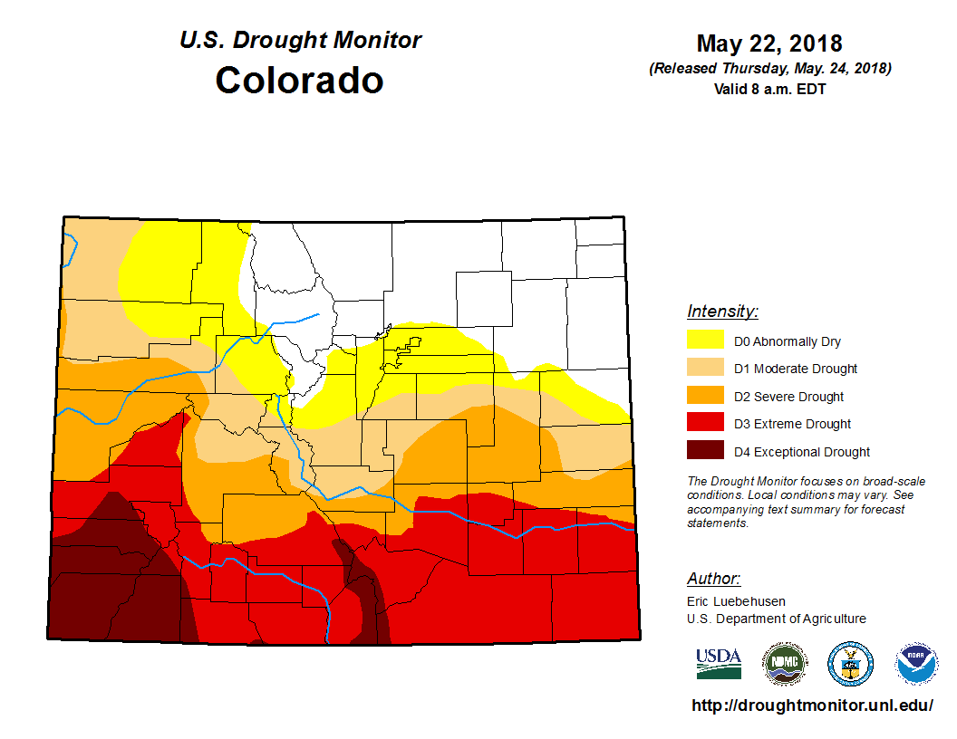
Before we get into the extended forecast for the FTO, it would be a good idea to take stock of how the longer time-frame of the drought monitor looks. Even though we’ve had plenty of thunderstorms in the forecast, the long-term picture isn’t good, as shown in the Drought Monitor image below. Moderate or worse drought grips more than 60% of the state, with much of the southern third of Colorado in the Extreme/Exceptional Drought categories. Unfortunately, the extended forecast that is presented below doesn’t offer much relief for those dealing with the worst of the drought.
To begin this FTO period, Friday and Saturday (May 25th/26th) will be marked by warm and mainly dry conditions as a quick ridge builds over the state. A few garden-variety afternoon/evening thunderstorms over the higher terrain, and drifting over adjacent valleys, are expected as daytime heating and orographic effects play on residual moisture, but they won’t result in much as atmospheric moisture remains limited. Event #1 makes an appearance as the approach of an upper-level low that centers itself over the Great Basin on Sunday, May 27th. It will be in no hurry to go anywhere, and will spin in place for a couple of days before weakening and finally lifting to the north/northeast on Tuesday, May 29th. At this point in time, the forecast calls for the upper-level low to remain positioned to keep the best moisture and rainfall north and west of Colorado. However, some low-level moisture is expected to return to northeast Colorado as easterly surface flow develops with the emergence of a surface low pressure center over the Southeastern Plains. This event will get a no apparent threat for now, but a shift of the low pressure track to the south/east of the current forecast position would open Colorado to more rainfall.
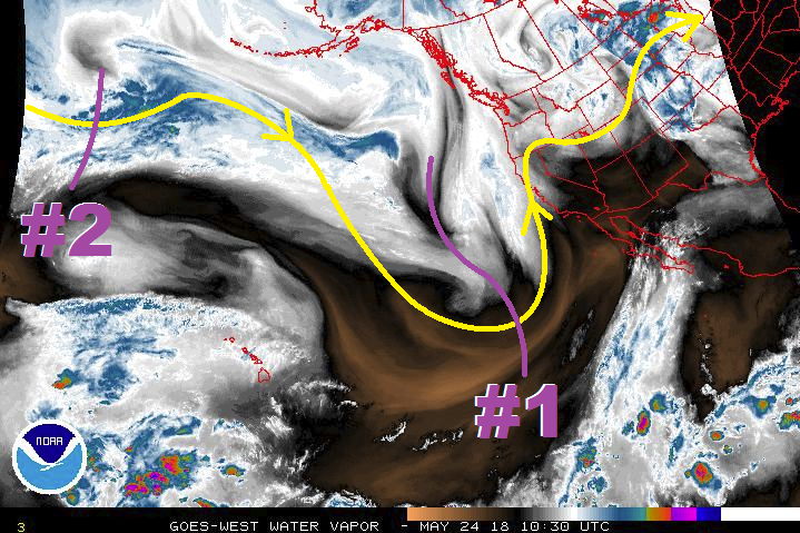
After Event #1, a transient “dirty ridge” will move into position over Colorado, allowing for a couple days (May 30th/May 31st) of decreasing numbers of storms and increasing temperatures. Daily afternoon/evening thunderstorms over/adjacent to the higher terrain will still be present thanks to daytime heating working on residual moisture. Event #2 will follow Friday, June 1st – Sunday, June 3rd in the form of a low-pressure trough that will follow a similar path to Event #1, keeping the best impacts north of Colorado. The place to watch, once again, will be northeast Colorado where southeasterly surface flow will attempt to bring low-level moisture into the area. It is that time of year where a few severe thunderstorms will likely attend this pattern, so this will need to be monitored over the next few days. After Event #2, Mother Nature will back off for the remainder of the period as strong ridging builds across the western US. This will bring a drying/warming trend to the state, but as is typical of Colorado during the summer months, garden-variety afternoon/evening thunderstorms over and near the higher terrain will likely accompany the otherwise sunny and dry days.
Event #1: Sunday (05-27-2018) through Tuesday (05-29-2018)
No Apparent Threat as Best Support Remains North and West of Colorado
Unfortunately for drought-stricken areas of Colorado, Event #1 is not expected to bring much relief as it keeps the best moisture/rainfall over Utah/Wyoming. The upper-level low will more-or-less stall for a couple of days before finally lifting to the north-northeast on Tuesday, May 29th. The best rainfall for Colorado will be across Northeast Colorado, as low-level moisture from the Great Plains is pulled into the area by easterly surface flow. No flood threat is apparent at this time, but be sure to monitor the daily FTB forecasts, as this type of pattern can result in small-scale threats that are best determined in the 24-hour timeframe.

Event #2: Friday (06-01-2018) through Sunday (06-03-2018)
No Apparent Threat as Low Pressure Trough Follows Similar Path to Event #1
The best rainfall from Event #2 is expected to stay north and west of Colorado as the upper-level trough takes a similar path to that taken by the first event. As has been the pattern so far this year, northeastern Colorado (including the Urban Corridor, Palmer Ridge, and Northeast Plains) will be the area to watch thanks to easterly surface flow advecting low-level moisture into the area. Patterns such as this one often result in some form of severe thunderstorm threat, so we will continue to monitor this pattern over the coming days and bring an update in Monday’s FTO. No precipitation map will be drawn due to forecast rainfall expected to be less than 0.5 inches.