Issue Date: 5/31/2018
Issue Time: 9:10 AM

This FTO period will get off to a slow start, with a short, one-day event being noted on Sunday, June 3rd, immediately followed by a fairly quiet and hot four-day period. To illustrate the upcoming 15 days, we turn (as usual) to the water vapor imagery to identify any large-scale potential for flooding events. Event #1 is easy to pick out on the water vapor image; it is currently the base of a long wave trough, but will become cut off from the main atmospheric flow, slowly progressing towards Colorado over the next 2-3 days, before finally encroaching on Colorado as a weak shortwave by Sunday, June 3rd. This will provide one day of scattered showers and thunderstorms to the state. Low-level moisture will be a bit on the low side, with “inverted-v” atmospheric sounding profiles precluding the issuance of any flood threat designation for this event. However, this event borders on needing a flood threat designation, and the appearance of more moisture than currently expected will likely result in a flood threat, so be sure to check in on the daily FTB for the most up-to-date forecast.
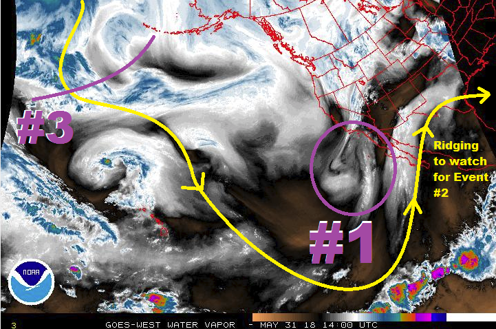
For Monday, June 4th through Thursday, June 7th, upper-level ridging will build across the south-central United States, placing Colorado under dry, westerly flow aloft and allowing temperatures to rise; it will be an early taste of summer heat before the official start of summer. Some locations across the eastern plains, especially those near the CO/KS border and those in the Arkansas River valley, will see temperatures flirt with 100 degrees. June 8th marks the start of Event #2 (continuing through Tuesday, June 12th), as the ridge axis slides far enough east for southwesterly flow aloft to funnel moisture from eastern Pacific/Gulf of California into Colorado. While this event resembles the monsoon, it is still too early for a good monsoon push. Instead, the dry desert air across the southwestern US will zap a lot of the moisture before it gets to the state, limiting daily thunderstorms to the high-based, garden-variety types. Eastern Colorado, if it is able to grab any moisture from the Great Plains, will be an area to watch for potential flood threats. At this time, no flood threat designation will be given to this time period.
Following quickly on the heels of the previous event, Event #3 will close out the period (Wednesday, June 13th – Friday, June 15th) with 3 days of daily showers/thunderstorms. A shortwave disturbance from the Pacific Northwest will flatten the stubborn ridge that had hung on over the central US for the better part of 8-10 days, providing a trigger the scattered thunderstorm development. At the current time, two big question marks that preclude the issuance of any flood threat designation are, 1) will enough moisture return to the state from the Great Plains/Gulf of Mexico, and 2) will this shortwave disturbance take a path favorable to rainfall in Colorado? The strength of the ridge will play a large role in how this scenario plays out – if the ridge is stronger than expected, this shortwave will stay to the north, leaving Colorado out to dry. With the uncertainty remaining, no flood threat designation will be assigned. Check back with Monday’s FTO for an update on this time period.
Event #1: Sunday (06-03-2018)
No Apparent Threat as Weak Shortwave Briefly Moves through the State
A weak shortwave will become cut off from the main atmospheric flow, slowly meandering its way from southern California towards Colorado. By the time it reaches Colorado, it will pick up enough speed to only bring one day of rainfall to the state. Even so, low-level moisture is expected to be on the low side, reducing the efficiency of rainfall production. Therefore, no flood threat designation is warranted. However, pay close attention to the daily FTB, because if moisture can make a better return to eastern Colorado than expected, a short-term flood threat may be warranted due to stronger thunderstorms and better rainfall efficiency.
<

Event #2: Friday (06-08-2018) through Tuesday (06-12-2018)
No Apparent Threat from “Monsoon-like” Event
Event #2 is the result of the high-pressure ridge axis shifting far enough to the east to allow for a weak funnel of moisture from the eastern Pacific/Gulf of California. The dry Desert Southwest will zap the moisture from the air before it can get to Colorado, severely hampering rainfall potential. High-based, garden-variety thunderstorms will be the main impact. East of the mountains, close attention will need to be paid to moisture return from the Great Plains/Gulf of Mexico. It’s that time of year where influxes of moisture can be brought on by small-scale surface boundaries, which are beyond the skill of any forecaster/model at this range. Monday’s FTO will provide a needed update on this time period.
Event #3: Wednesday (06-13-2018) through Friday (06-15-2018)
No Apparent Threat due to High Uncertainty
High uncertainty hovers over this potential event, with the strength of the ridge playing a key role in the resulting weather. A strong ridge will keep the shortwave north of the state, leaving Colorado out to dry with hot temperatures. If the ridge weakens, the shortwave will be able to flatten the ridge and impact Colorado, bringing a period of showers and thunderstorms to the state. Stay tuned.