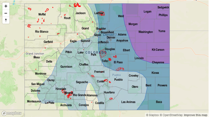
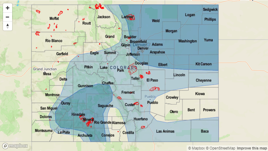
Issue Date: Monday, June 4th, 2018
Issue Time: 1:15PM MDT
Valid Dates: 6/5 – 6/19
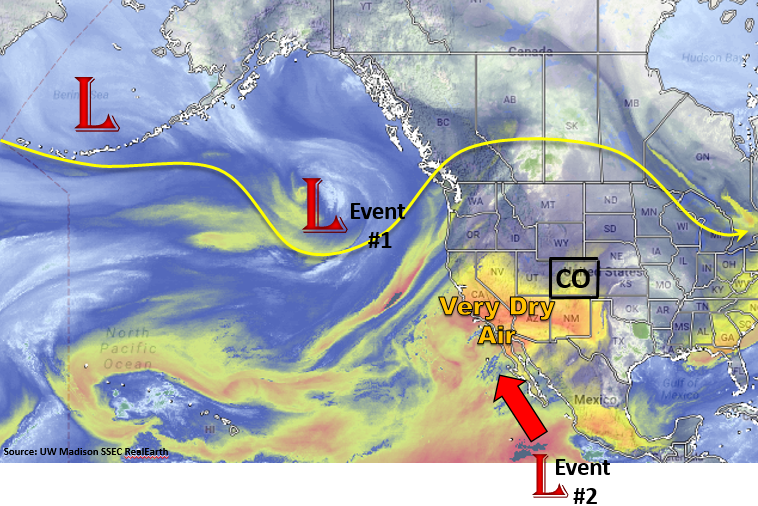
The start of this 15-day flood outlook will be dominated by a ridging pattern over Colorado. With the jet stream well to the north of Colorado, this will be a very summer-like period marked with high temperatures through this weekend and limited heavy rainfall potential. The more westerly wind component will pull in very arid air (marked below in orange), which will dry out the atmosphere allowing for only isolated showers to form over the higher terrains each afternoon with the diurnal flow pattern. Low dew points will cause garden variety showers and thunderstorms to produce gusty winds rather than heavy rainfall for the first part of this week. Should these storms stay intact as they reach the eastern plains, some local heavier rainfall will be possible due to higher dew points. Tuesday, some stronger storms could form over the far Southeast Plains along a dry line, but at this time the flooding is not expected as 15-20 knot storm motion will limit rainfall totals under 1.5 inches/hour.
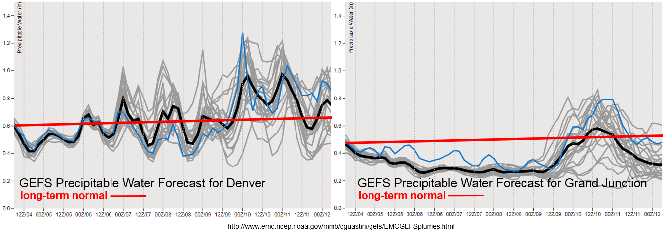
Towards the end of the week the ridge axis shifts to the east of Colorado allowing an uptick in moisture over Denver and Grand Junction (Event #1). This increase can be seen in the GEFS Precipitable Water (PW) plume forecasts for Denver and Grand Junction below. Southwesterly flow will pull in Pacific/Gulf of CA moisture into southwestern/southern Colorado and strong south/southeasterly winds east of the Continental Divide will pull in moisture from the Gulf of Mexico. Thus, there should be an uptick in afternoon thunderstorm coverage and the potential for some heavier rainfall on Saturday into Sunday with slower storm motion under the ridge. Thunderstorm coverage will still be isolated.
At the start of next week, the GEFS hints at a tropical system moving north along the Baja and into Southern California (Event #2). This tropical system has yet to form, but if it does it would draw in very high PW water values into western and southern Colorado similar to the monsoon pattern. Paired with some shortwave action as the low begins to disperse, this could cause some very heavy rainfall across the San Juan, Central and Southeast Mountains next Tuesday, Wednesday and Thursday. Confidence in this current solution is low, but it will increase closer to this event. So, be sure to check back to Thursday’s FTO. Below we describe each of the two identified precipitation events in more detail.
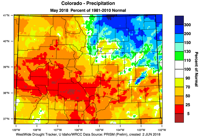
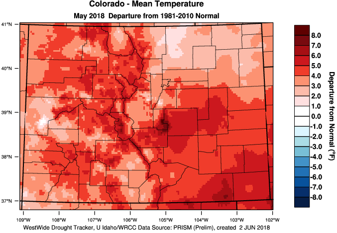
In other news, we have been highlighting the ongoing drought over southern Colorado. Below are the precipitation and temperature anomalies for the month of May from the WRCC. The two days of heavy rainfall in late May over the northeast plains and Urban Corridor helped precipitation values rise to 150-200% above normal. Elsewhere, May was quite dry with isolated portions of the Central Mountains and Grand Valley at less than 5% of normal precipitation. Statewide, temperatures were above well above average. As expected, the warmer temperatures helped dry out the little ground moisture from this winter’s snowpack, which increased fire danger across the the state. We are still looking at critical fire danger across the southern portion of the state this FTO period due to dry fuels and high temperatures in the 90s each day.
Event #1: Thursday (6/7) – Sunday (6/10)
Elevated Flood Threat/No Apparent Threat as the ridge axis slides east and allows an increase in PW for more widespread thunderstorm activity.
The surface high pressure begins to move eastward, which will allow moisture return southwest and eastern CO. With PW values moving closer to 1 inch and light steering flow under the ridge, some isolated heavy rainfall will be likely on Friday and Saturday. The most favored region for thunderstorm activity will be the San Juan Mountains, Southeast Mountains and Northeast Plains; however, the heavier rainfall should be limited to the Northeast Plains. The fire scars over the Southeast Mountains may need to be watched for excessive runoff. Isolated flash flooding, debris slides and mud flows will be possible over the mountains.
Event #2: Tuesday (6/12) – Friday (6/15)
Elevated Flood Threat/No Apparent Threat as a tropical system brings high PW to the San Juan and Southeast Mountains and strong southeast winds increase PW over the Northeast Plains.
Currently, the GFS is producing a tropical system that moves up the coast of the Baja and into Southern CA. If this transpires, this would supply ample moisture return to southwest and southern Colorado similar to the monsoon pattern. Currently, it is unknown if this system will develop and when the timing of the heaviest rainfall would be. Threats could include flash flooding, debris slides and mud flows over the steeper terrains. Over the plains, field ponding and flooding of low elevation roads are possible. Be sure to check back to Thursday’s FTO for more details as this forecast is likely to change quite a bit.

