FTO 07-16-2018: Elevated Flood Threat for Tuesday then Drying Pattern Until this Weekend

Issue Date: Monday, July 16th, 2018
Issue Time: 1:10PM MDT
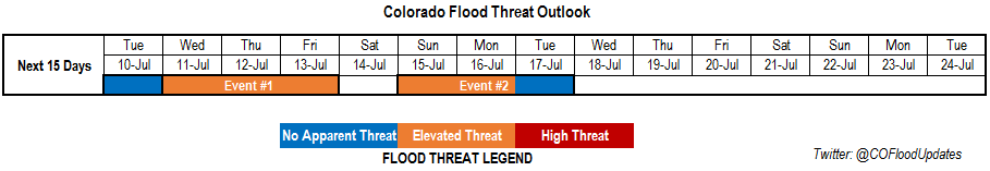
Valid Dates: 7/17– 7/31

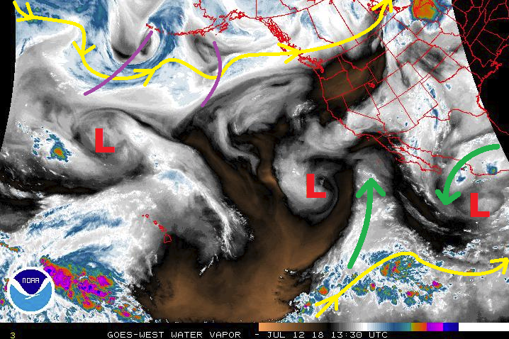
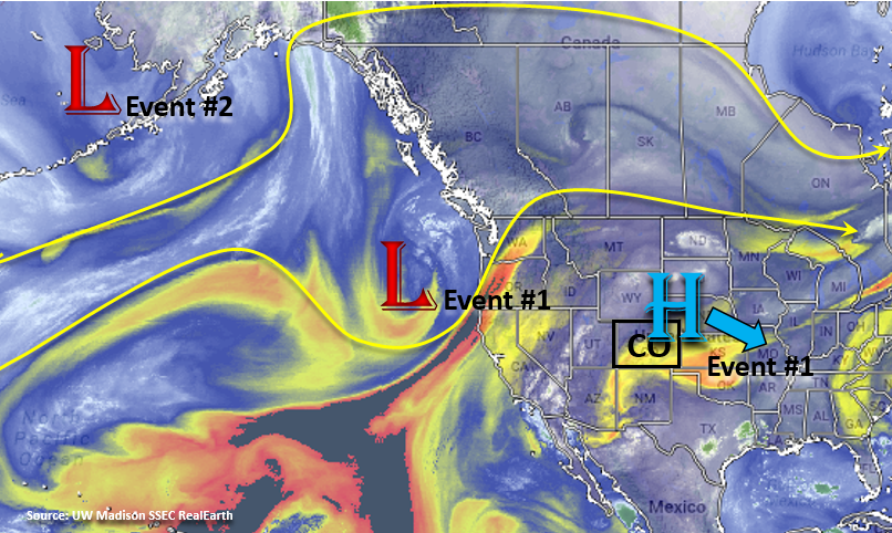
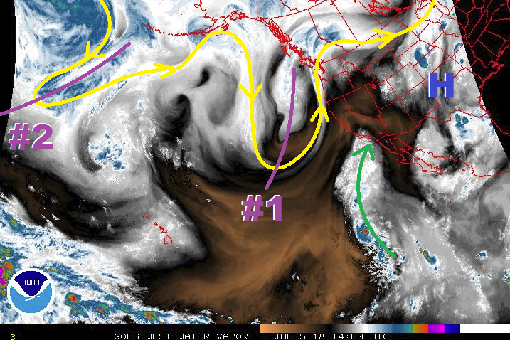
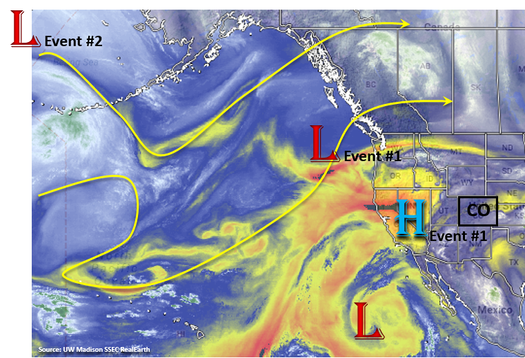
For the next FTO period, expect on and off rainfall as the upper level ridge builds and then breaks down as upper troughs move through the Pacific Northwest. The first event in this period is ongoing from the last FTO. Currently, there is a weak high pressure ridge that has formed over the Great Basin. This has drawn in some dry air over northern Colorado and reduce available moisture of widespread showers and thunderstorms this afternoon. Tomorrow, the Low over the Pacific Northwest will begin to migrate to the east and flatten out the ridge. As the Low passes over Colorado, upper level shortwaves will be passed from the low around the high pressure during the afternoon. This will enhance lift for the afternoon orographic driven storms and spark more widespread showers and thunderstorms over the northern mountains. By the late afternoon/early evening, some more thunderstorms will move off the Cheyenne Ridge and northern Front Range into the Northeast Plains. With sufficient upper level support and abundant moisture from low level southeast flow during the day, the storms should continue overnight into Wednesday morning. After Event #1, the ridge builds back in place and begins to pull in drier air with very hot temperatures expected Wednesday and Thursday. There will still be some antecedent moisture under the ridge, so expect isolated showers and thunderstorms Wednesday and Thursday over the higher terrains, but without a flood threat. By Friday, a second upper low moves into the Pacific Northwest and breaks down the ridge. This will allow more southwest/west flow in the upper levels and subtropical moisture to be drawn back into southern and western Colorado. It’s a bit too early to tell how far north this moisture will be pulled, but right now the greatest chance for rainfall will be over the southern and western mountains. With PW values on the increase, there is a return of a flood threat over the weekend especially over the burn scars that have caused such problems the last few weeks. Sunday, the GFS hints at a frontal passage with the passing upper trough, which would moisten the low-levels for abundant rainfall Sunday afternoon. This may generate a flood threat for the Northeast Plains and Palmer Ridge, but it’s a bit too early for all the details to come together.

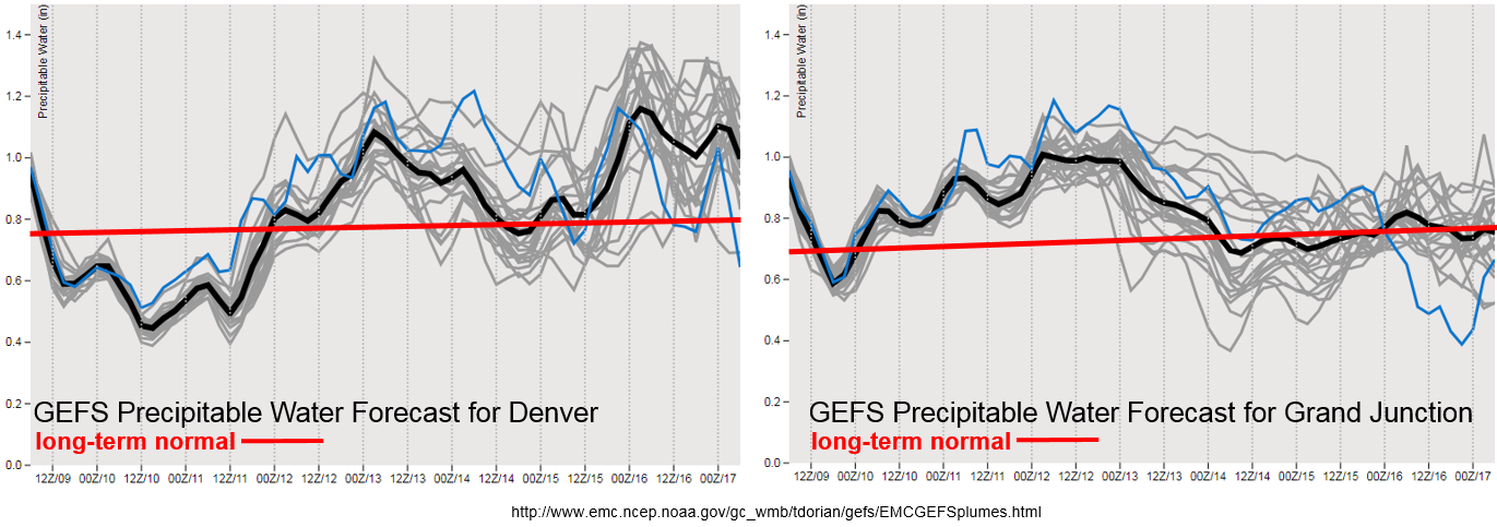
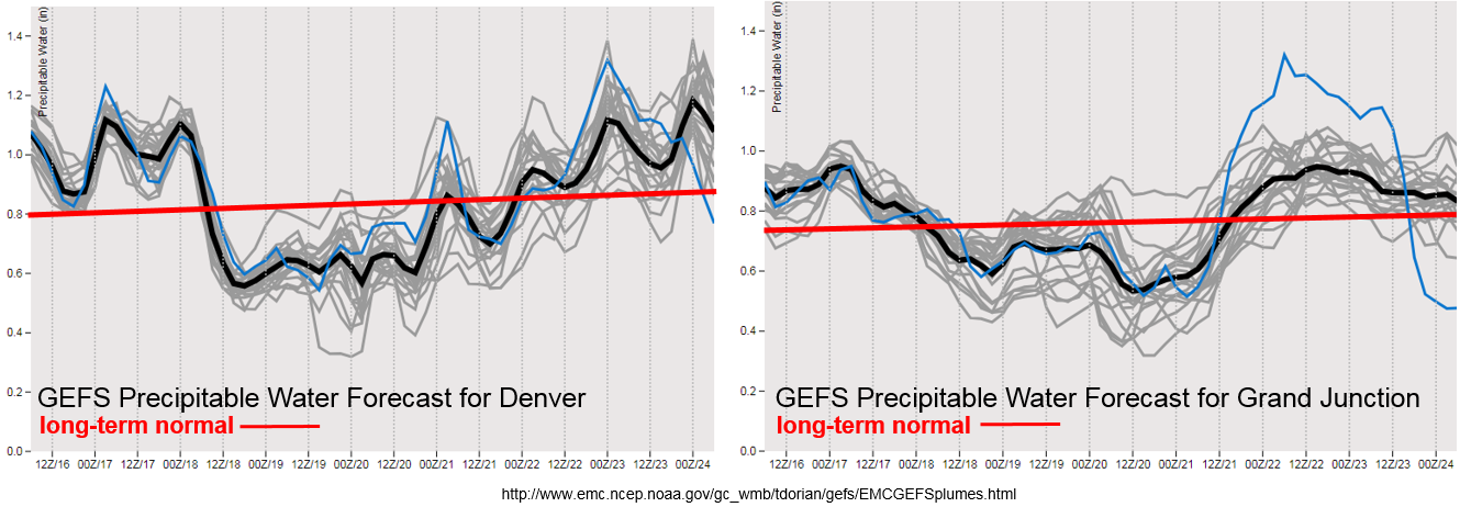
Precipitable Water (PW) remains high over Colorado through tomorrow. After this, PW drops off both east and west of the Divide to below the climatological average as the high pressure builds in to the west and dries out the atmosphere with more northerly flow. By Friday, the PW values begin to creep back up above average as the elongated upper high weakens and is more centered over AZ/TX. This will allow subtropical moisture to return with upper level southwest/westerly flow to southern and western Colorado for a heavy rainfall threat. Even with the on and off return of subtropical moisture the last few weeks, none of these patterns are a typical southwest monsoon setup. Also, it is typical this time of year for surface high pressures to move southward over the state from Canada and provide return southeasterly flow to Colorado. The surface highs have stayed well east of Colorado for most of this season. By the end of this FTO period, there does seem to be an eastward shift of the center of the subtropical high, but it is still very unclear whether or not it will set up over OK/AR/MO pulling in Gulf of Mexico moisture on its west side (monsoon pattern). I guess only time will tell.

Below we describe the two identified precipitation event of this FTO in more detail.

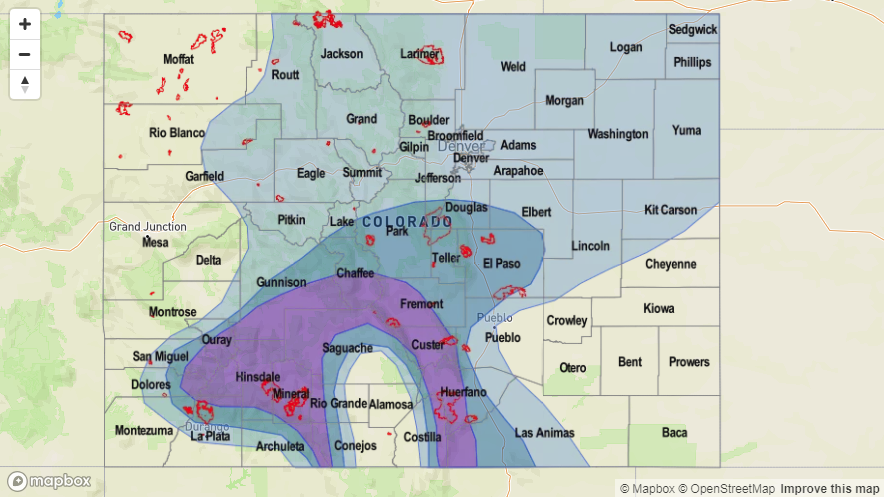
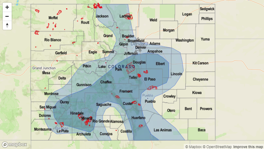
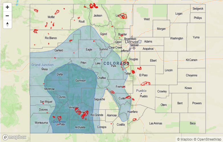
Event #1: Tuesday (7/17)

Elevated for afternoon, terrain induced thunderstorms and an overnight MCS over the Northeast Plains.

The high pressure to the west of Colorado begins to break down as the upper trough passes to the north of Colorado. As the trough passes, it will release numerous shortwaves that will rotate around the upper high. This will help kick off more widespread thunderstorms over the northern mountains. By the early evening, expecting some strong storms to move off the Cheyenne Ridge and northern Front Range into the Northeast Plains. Southeast flow at the low levels will bring abundant moisture into the region. With high moisture, an MCS will likely set up and bring heavy rainfall to the Northeast Plains and become sustained overnight thanks to help from the low level jet. High PW values will also continue over the southern high terrains. Thus, the flooding threat with the slow steering winds will stick around one more day before the ridge begins to build back to the west and dry out the atmosphere. Max 1-hour rain rates up to 1 inch are possible over the higher terrains with rain rates up to 2 inches/hour over the Northeast Plains.


Legend

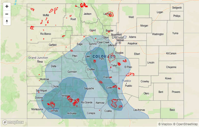
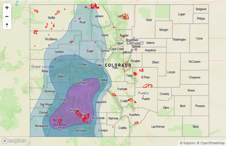
Event #2: Friday (7/20) – Monday (7/23)

Elevated/No Apparent Threat as subtropical moisture returns to Southeast Colorado when the upper ridge shifts southeast.

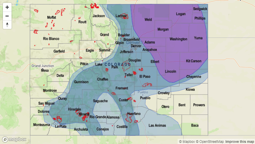
The second event of this FTO period will mostly be for the Southeast Mountains and western high terrains. PW values just below 1 inch return for this weekend as the high shifts to the southeast and allows subtropical moisture to be pulled back into southern and western Colorado. Where the center of the high sets up will determine how far north the high PW values can return, so there is some uncertainty in the forecast at this time. Burn scars over the mountains will also be under the gun once again as rain rates greater than 0.75 inches/hour are likely. The slow moving nature of the storms will also increase the chances of flooding across all these regions. Threats include mud flows and debris slides over the higher terrains and flash flooding of small streams/low-lying roadways over the adjacent plains. A cold front looks to move through the region on Sunday, and if this happens, this will be the day with the greatest flood threat as it would moisten the lower levels and increase rain rates behind it.


Legend

FTO 07-12-2018: Uncertainty Reigns as Complicated Weather Regime Takes Shape

Issue Date: 7/12/2018
Issue Time: 9:40 AM

A “chaotic weather regime” is the best way to describe the weather pattern over the Pacific, and this has the negative effect of adding extra uncertainty to the extended forecast. Here in Colorado, the best way to break down the next 15 days will be to discuss the meandering upper-level high, which will take turns opening Colorado to subtropical moisture, upper-level disturbances, cool fronts from the north, and periods of hot summer weather. This FTO period kicks off quickly, with Event #1 slated for the first 4 days (Friday, July 13th – Monday, July 16th). The upper-level high pressure will begin to build over the western US on Friday, which will allow for the each day to be drier than the previous day, as subtropical moisture gets shunted south of the state. Even so, there will be enough residual moisture trapped underneath the ridge to generate daily showers/thunderstorms, with the bulk of activity focused over the higher terrain. If the upper-level ridge centers far enough southwest, northwesterly flow will return to eastern Colorado, allowing the influence of disturbances aloft (purple lines on the water vapor image) and surface cool fronts to bring additional support for thunderstorms, which would increase the precipitation expected. This will be monitored closely.

At any rate, due to the number of recent/ongoing fire burn areas scattered across the higher terrain, an Elevated Flood Threat has been issued for Event #1. It will be important to monitor the daily FTB forecasts; they will provide the most up-to-date and specific flood threat information. By late Monday, the upper-level high is expected to shift back over Utah/western Colorado, which will help suppress thunderstorm activity and allow the state to dry through Thursday. Daily isolated, high-based showers/weak thunderstorms will still hug ridge tops during this time frame, as is typical of the Colorado summertime, with the result being more gusty winds than rain.
Event #2 will make its appearance beginning on Friday, June 20th, as an upper-level disturbance flattens the ridge. This elongated high pressure will open Colorado to influence from cool fronts moving in from the northwest in association with any additional shortwave disturbances, with drier westerly flow aloft. While this type of scenario will generally be unfavorable for storms along/west of the Continental Divide, it will be favorable for storms to the east as upslope flow behind cool fronts will transport low-level moisture from the Great Plains into eastern Colorado. This period should be watched for the return of a few strong-to-severe storms capable of heavy rain from the foothills to the eastern border. Unfortunately, the current large-scale pattern we find ourselves in lends itself to more uncertainty in the medium- and long-range forecasts, so there isn’t enough confidence for any flood threat designation. Event #2 will continue through the weekend, ending Monday, July 23rd.

After Event #2 comes to a close, upper-level high pressure will once again strengthen across the region, allowing Colorado to heat up and dry out as we head towards August. Daily afternoon/evening thunderstorms over/near the higher terrain will likely still be in the forecast, but that should be about it. We will keep an eye on this time period as it draws nearer, and will provide an update during Monday’s FTO.

Event #1: Friday (07-13-2018) through Monday (07-16-2016)

Elevated Flood Threat Mainly Due to Recent/Ongoing Fire Burn Areas
An upper-level ridge will try to build over the western United States, drying out Colorado little by little over the event period as subtropical moisture gets shunted south of the state. However, residual moisture and precipitable water values that are slow to come down will aid the development of daily afternoon/evening thunderstorms, mainly over/near the higher terrain. We will be monitoring closely the eventual position of the upper-level high; if it is located far enough south/southwest, northwest flow aloft, surface cool fronts, and increased moisture transport from the Great Plains into eastern Colorado will bring the threat of heavy rain from the Front Range to the eastern border. It will be important to stay up-to-date with the daily FTB.

Recent and ongoing fire burn scars are the main culprit behind the Elevated Flood Threat designation.

Legend

Event #2: Friday (07-20-2018) through Monday (07-23-2018)

No Apparent Flood Threat due to Uncertainty in the Weather Pattern
The position and elongation of the upper-level high will open Colorado to the influence of passing upper-level disturbances and cool fronts from the north, making this period a focus on eastern Colorado. Upslope flow behind any cool fronts will transport Great Plains moisture into eastern Colorado and back into the Front Range, setting the stage for the return of strong-to-severe thunderstorms capable of heavy rain. Unfortunately, uncertainty in the placement of large-scale features such as the upper-level high leave uncertainty too great for a precipitation map and flood threat designation. We will closely monitor this time frame, and have an update in Monday’s FTO.

FTO 07-09-2018: Afternoon Thunderstorms with Off and On Access to Subtropical Moisture

Issue Date: Monday, July 9th, 2018
Issue Time: 1:55PM MDT
Valid Dates: 7/10– 7/24

Before getting started on the FTO for this next period, let’s take a look a look back June’s climatology and the June 2018 Colorado Reservoir Storage Summary for the State of Colorado (source: HPRCC and NRCS). June was very warm compared to climatology with above average temperatures across the entire state. Most areas were 2-4F above average, with the warmest region over the Southeast Mountains and adjacent Southeast Plains. High temperatures were 6-8F above normal. As far as precipitation, the Southwest Slope and eastern San Juan Mountains received anywhere between 0.25 to 1 inch more than June climatology. Other areas that were above average for precipitation during June were the far Northeast Plains and northern Front Range. Elsewhere, precipitation was 5-25 percent of normal with the lowest percent of normal over the Southeast Mountains, Southeast Plains and Northwest Slope. Despite above average precipitation over the southeast corner of the state, reservoirs are anywhere between 60-80% of average. Reservoir storage at the beginning of May in this area was close to 100%, so quite a bit of water has been used. Hopefully the onset of the monsoon season will bring plentiful moisture to this area without triggering mud flows and debris slides over the burn scars. Elsewhere, storage remains high with most watersheds well above average and close to capacity. Statewide, Colorado is looking pretty good going into June (especially considering this year’s low snowpack) sitting at 97% of average. However, this is down 17% when compared to this time last year.

Moving back into the forecast, afternoon thunderstorms over the higher terrains with on and off access to subtropical moisture will define this next FTO period. Colorado will remain under a ridging pattern, which will bring warm temperatures the rest of this week. Models are hinting at a cold front moving through this weekend, which will be a welcomed respite from the heat should that forecast stay on track. Currently, the upper-level high pressure is sitting on the north side of Colorado and can be seen in the water vapor imagery below. The low pressure over the west coast will move northeast starting tomorrow, which will shift the ridge axis to the east. Then by Wednesday, the center of the high pressure system will be located over MO/AR and spin in place through Friday. These two features will define Event #1. After Event #1, the ridge will begin building back to the west. A second upper trough pushes through the northern US starting on Saturday afternoon (Event #2), which will make the upper flow more zonal and maybe even give the flow more of a northerly component.  The position of the high pressure at this time (west of Colorado), is expected to keep the higher moisture south. There is quite a bit of uncertainty with the forecast after this weekend due to not having high confidence in the exact positioning of the high pressure, which will directly affect the moisture return.

Precipitable Water (PW) over Colorado should be high enough over the next week to allow afternoon upslope flow to develop scattered thunderstorms over the higher terrains each afternoon. The daily location of greatest rainfall and highest coverage is hard to predict more than a couple days out, so check back to the FTB for details. By mid-week, PW jumps quite a bit both east and west of the Continental Divide. The moisture returns more quickly to the southwest corner/western Colorado, and then as the high pressure continues to spin to the east, moisture returns to eastern Colorado. This monsoon flow, will create an Elevated Flood Threat at the end of this week. Rain rates will be high enough that if storms track over recent burn scars in the Southeast and San Juan Mountains, mud flows and debris slides could occur. Moisture decreases after Friday west of the Divide, so not as worried about burn scars this weekend. Sunday afternoon, PW increases east of the Divide. Once again, slow moving thunderstorms and high moisture content of the atmosphere will bring another Elevated Flood Threat to the Front Range, Southeast Mountains, Palmer Ridge and adjacent plains Sunday – Tuesday. This will be especially true if the passage of the cold front moistens the lower levels of the atmosphere later this weekend.

Below we describe the two identified precipitation event of this FTO in more detail.

Event #1: Tuesday (7/10) – Friday (7/13)

Elevated/No Apparent Threat for afternoon, terrain induced thunderstorms with subtropical moisture.

With the high pressure setting up to the east of Colorado, the ridge axis will allow subtropical moisture to return to the state. At first, the moisture will move into southwestern and western Colorado, but by Thursday, the subtropical moisture will have made its way east of the Continental Divide. Despite on and off again moisture, there should be enough moisture to allow for thunderstorm development each afternoon with upslope flow over the higher terrains. With the exception of Friday, not expecting thunderstorms over the eastern plains. With PW greater than 1 inch later this week, the slow moving storms are expected to produce flash flooding. Over the mountains, threats include mud flows, debris slides and local stream flooding. This is especially true if any of these storms track over recent burn scars. Over the adjacent plains, highly impervious urban areas may experience street flooding, field ponding and local stream flooding. For specific details about coverage of the thunderstorms each day and rain rates, please check back to the FTB posted daily by 11AM.


Legend


Event #2: Sunday (7/15) – Tuesday (7/17)

Elevated/No Apparent Threat as subtropical moisture returns to Southeast Colorado.

The second event of this FTO period will mostly be for the Southeast Mountains, Palmer Ridge, Southern Front Range and the adjacent plains. PW values greater than 1 inch are currently forecast return at the beginning of next week. Where the ridge sets up will determine how far north the high PW can return, so there is some uncertainty in the forecast at this time. There is still a chance for some more isolated showers over the San Juan Mountains, so this will be monitored closely as it will only take 0.25-0.5 inches/hour to trigger flash flooding over the recent burn scars. Burn scars over the Southeast Mountains will also be under the gun once again as rain rates up to 1 inch/hour are possible. The slow moving nature of the storms will increase the chances of flooding over the areas they track. Of course, these high rain rates all depend on if PW returns to the values predicted by the GEFS. At this time it is impossible to predict the exact location of the flooding, though heavier rain should favor the Southeast Mountains, Raton Ridge and Palmer Ridge.


Legend

FTO 07-05-2018: The First Breath of the 2018 Monsoon

Issue Date: 7/5/2018
Issue Time: 11:10 AM

This FTO period is very front-heavy, with two events in the first 5 days, and then no apparent events through the remainder of the period. With Event #1 designated as a High Flood Threat, and Event #2 designated as an Elevated Flood Threat, we’re just going to dive straight into the discussion today, focusing on the key points surrounding the flood threats.

Monsoon season is drawing near, and the first real breath of the 2018 monsoon is the main culprit behind both Event #1 and Event #2. Highlighted in the water vapor image below are the large-scale features of note for this period; we will break them down with each individual event. Event #1 will begin on Friday, July 6th, as the broad upper-level High centered over the Great Plains shifts eastward with the approach of the upper-level trough denoted by the purple “#1”. These features will funnel Pacific moisture across the southwestern US (green arrow) and into western Colorado, as well as make use of the residual moisture from the Gulf of Mexico already impacting the state today. This funneling of moisture will focus the bulk of shower/thunderstorm activity along/west of the Continental Divide, with precipitable water values well above normal across much of western Colorado. This deep moisture, combined with fairly weak steering flow, will bring the threat of heavy rain and slow-moving thunderstorms to susceptible terrain and sensitive burn scars, such as the 416 Fire, Burro Fire, and West Fork Complex Fire. There is enough potential for heavy rainfall, or extended periods of moderate rainfall, impacting these areas that the trigger has been pulled on a High Threat designation. Event #1 continues through Sunday, July 8th, when the upper-trough will exit across the northern US, and the next upper-level trough follows closely behind.

Event #2 begins immediately after Event #1, on Monday, July 9th, as the next upper-level trough digs into the western US, forcing southwesterly flow to remain over the state and continuing the funnel of Pacific moisture into western Colorado. Event #2, just as Event #1, will be mainly a western Colorado event, but Event #2 will hold some potential for heavy rain along the Front Range and Southeast Mountains, extending eastward slightly to adjacent lower elevations. The upper-level trough will exit the region across the northern Rockies late Tuesday/early Wednesday (July 10th/July 11th). A bit of uncertainty in the eventual evolution of Event #2 precludes the issuance of a high threat, but an Elevated Threat is warranted at this time.

After Event #2, the remainder of this FTO period will see the upper-level ridge dominate the weather pattern over Colorado once again, resulting in hot temperatures and sparser, high-based thunderstorm activity. Diurnal showers/thunderstorms over the higher terrain will be likely, as is typical of hot summer days in Colorado, with the potential for them to drift over adjacent lower elevations. No flood threat highlights are warranted at this time.

Event #1: Friday (07-06-2018) through Sunday (07-08-2018)

High Flood Threat from the first breath of Deep, Monsoonal Moisture

The favorable position of an upper-level trough to the west and an upper-level high centered over the central US will funnel Pacific moisture into western Colorado. This deep moisture will coincide with relatively weak steering flow, meaning that slow-moving thunderstorms capable of heavy rainfall will be a threat to susceptible terrain and sensitive burn scars, especially new burn scars like the 416 Fire and Burro Fire. Please monitor the daily FTB for more information regarding each specific day’s flood threat.

Legend

Event #2: Monday (07-09-2018) and Tuesday (07-10-2018)

Elevated Flood Threat as the Moisture Funnel Continues

Following immediately on the heels of Event #1, Event #2 is more of the same, with the funnel of Pacific moisture continuing thanks to the second upper-level trough positioning itself favorably. Just as Event #1, this is mainly an event for areas along/west of the Continental Divide, but a bit stronger steering flow to the east will allow for a few storms to impact the Front Range, Southeast Mountains, and adjacent lower elevations. Uncertainty in the eventual evolution of the event precludes Event #2 from being designated as a High Flood Threat, but the presence of deep moisture, instability, and relatively weak steering flow are enough to warrant the Elevated Flood Threat. We will continue to monitor Event #2, and the daily FTB’s will provide up-to-date information.

Legend