Issue Date: 7/5/2018
Issue Time: 11:10 AM

This FTO period is very front-heavy, with two events in the first 5 days, and then no apparent events through the remainder of the period. With Event #1 designated as a High Flood Threat, and Event #2 designated as an Elevated Flood Threat, we’re just going to dive straight into the discussion today, focusing on the key points surrounding the flood threats.
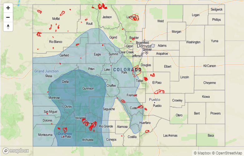
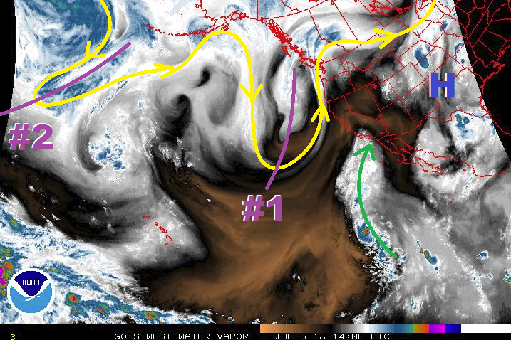
Monsoon season is drawing near, and the first real breath of the 2018 monsoon is the main culprit behind both Event #1 and Event #2. Highlighted in the water vapor image below are the large-scale features of note for this period; we will break them down with each individual event. Event #1 will begin on Friday, July 6th, as the broad upper-level High centered over the Great Plains shifts eastward with the approach of the upper-level trough denoted by the purple “#1”. These features will funnel Pacific moisture across the southwestern US (green arrow) and into western Colorado, as well as make use of the residual moisture from the Gulf of Mexico already impacting the state today. This funneling of moisture will focus the bulk of shower/thunderstorm activity along/west of the Continental Divide, with precipitable water values well above normal across much of western Colorado. This deep moisture, combined with fairly weak steering flow, will bring the threat of heavy rain and slow-moving thunderstorms to susceptible terrain and sensitive burn scars, such as the 416 Fire, Burro Fire, and West Fork Complex Fire. There is enough potential for heavy rainfall, or extended periods of moderate rainfall, impacting these areas that the trigger has been pulled on a High Threat designation. Event #1 continues through Sunday, July 8th, when the upper-trough will exit across the northern US, and the next upper-level trough follows closely behind.
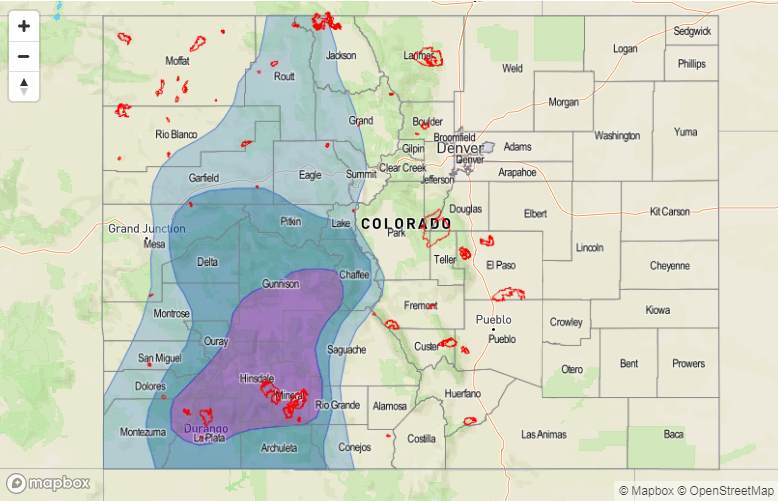
Event #2 begins immediately after Event #1, on Monday, July 9th, as the next upper-level trough digs into the western US, forcing southwesterly flow to remain over the state and continuing the funnel of Pacific moisture into western Colorado. Event #2, just as Event #1, will be mainly a western Colorado event, but Event #2 will hold some potential for heavy rain along the Front Range and Southeast Mountains, extending eastward slightly to adjacent lower elevations. The upper-level trough will exit the region across the northern Rockies late Tuesday/early Wednesday (July 10th/July 11th). A bit of uncertainty in the eventual evolution of Event #2 precludes the issuance of a high threat, but an Elevated Threat is warranted at this time.
After Event #2, the remainder of this FTO period will see the upper-level ridge dominate the weather pattern over Colorado once again, resulting in hot temperatures and sparser, high-based thunderstorm activity. Diurnal showers/thunderstorms over the higher terrain will be likely, as is typical of hot summer days in Colorado, with the potential for them to drift over adjacent lower elevations. No flood threat highlights are warranted at this time.
Event #1: Friday (07-06-2018) through Sunday (07-08-2018)
High Flood Threat from the first breath of Deep, Monsoonal Moisture
The favorable position of an upper-level trough to the west and an upper-level high centered over the central US will funnel Pacific moisture into western Colorado. This deep moisture will coincide with relatively weak steering flow, meaning that slow-moving thunderstorms capable of heavy rainfall will be a threat to susceptible terrain and sensitive burn scars, especially new burn scars like the 416 Fire and Burro Fire. Please monitor the daily FTB for more information regarding each specific day’s flood threat.

Event #2: Monday (07-09-2018) and Tuesday (07-10-2018)
Elevated Flood Threat as the Moisture Funnel Continues
Following immediately on the heels of Event #1, Event #2 is more of the same, with the funnel of Pacific moisture continuing thanks to the second upper-level trough positioning itself favorably. Just as Event #1, this is mainly an event for areas along/west of the Continental Divide, but a bit stronger steering flow to the east will allow for a few storms to impact the Front Range, Southeast Mountains, and adjacent lower elevations. Uncertainty in the eventual evolution of the event precludes Event #2 from being designated as a High Flood Threat, but the presence of deep moisture, instability, and relatively weak steering flow are enough to warrant the Elevated Flood Threat. We will continue to monitor Event #2, and the daily FTB’s will provide up-to-date information.