Issue Date: Monday, July 16th, 2018
Issue Time: 1:10PM MDT
Valid Dates: 7/17– 7/31
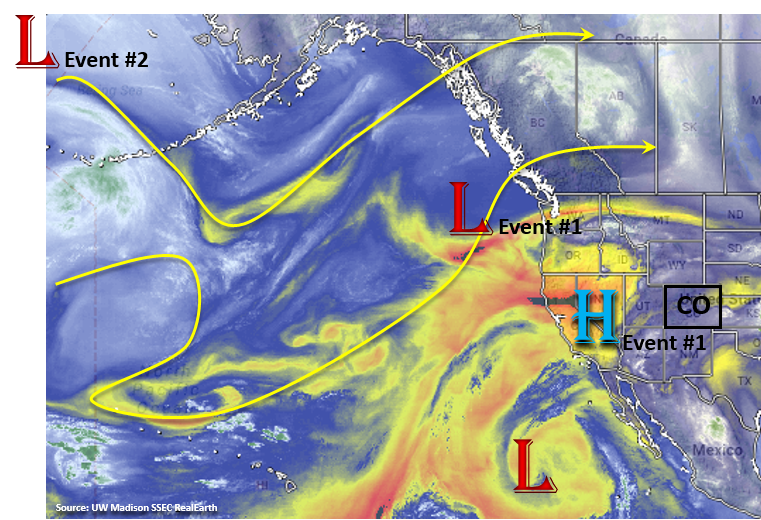
For the next FTO period, expect on and off rainfall as the upper level ridge builds and then breaks down as upper troughs move through the Pacific Northwest. The first event in this period is ongoing from the last FTO. Currently, there is a weak high pressure ridge that has formed over the Great Basin. This has drawn in some dry air over northern Colorado and reduce available moisture of widespread showers and thunderstorms this afternoon. Tomorrow, the Low over the Pacific Northwest will begin to migrate to the east and flatten out the ridge. As the Low passes over Colorado, upper level shortwaves will be passed from the low around the high pressure during the afternoon. This will enhance lift for the afternoon orographic driven storms and spark more widespread showers and thunderstorms over the northern mountains. By the late afternoon/early evening, some more thunderstorms will move off the Cheyenne Ridge and northern Front Range into the Northeast Plains. With sufficient upper level support and abundant moisture from low level southeast flow during the day, the storms should continue overnight into Wednesday morning. After Event #1, the ridge builds back in place and begins to pull in drier air with very hot temperatures expected Wednesday and Thursday. There will still be some antecedent moisture under the ridge, so expect isolated showers and thunderstorms Wednesday and Thursday over the higher terrains, but without a flood threat. By Friday, a second upper low moves into the Pacific Northwest and breaks down the ridge. This will allow more southwest/west flow in the upper levels and subtropical moisture to be drawn back into southern and western Colorado. It’s a bit too early to tell how far north this moisture will be pulled, but right now the greatest chance for rainfall will be over the southern and western mountains. With PW values on the increase, there is a return of a flood threat over the weekend especially over the burn scars that have caused such problems the last few weeks. Sunday, the GFS hints at a frontal passage with the passing upper trough, which would moisten the low-levels for abundant rainfall Sunday afternoon. This may generate a flood threat for the Northeast Plains and Palmer Ridge, but it’s a bit too early for all the details to come together.
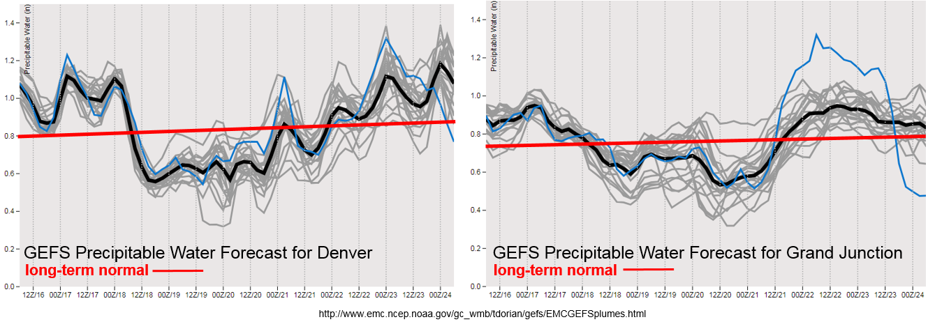
Precipitable Water (PW) remains high over Colorado through tomorrow. After this, PW drops off both east and west of the Divide to below the climatological average as the high pressure builds in to the west and dries out the atmosphere with more northerly flow. By Friday, the PW values begin to creep back up above average as the elongated upper high weakens and is more centered over AZ/TX. This will allow subtropical moisture to return with upper level southwest/westerly flow to southern and western Colorado for a heavy rainfall threat. Even with the on and off return of subtropical moisture the last few weeks, none of these patterns are a typical southwest monsoon setup. Also, it is typical this time of year for surface high pressures to move southward over the state from Canada and provide return southeasterly flow to Colorado. The surface highs have stayed well east of Colorado for most of this season. By the end of this FTO period, there does seem to be an eastward shift of the center of the subtropical high, but it is still very unclear whether or not it will set up over OK/AR/MO pulling in Gulf of Mexico moisture on its west side (monsoon pattern). I guess only time will tell.
Below we describe the two identified precipitation event of this FTO in more detail.
Event #1: Tuesday (7/17)
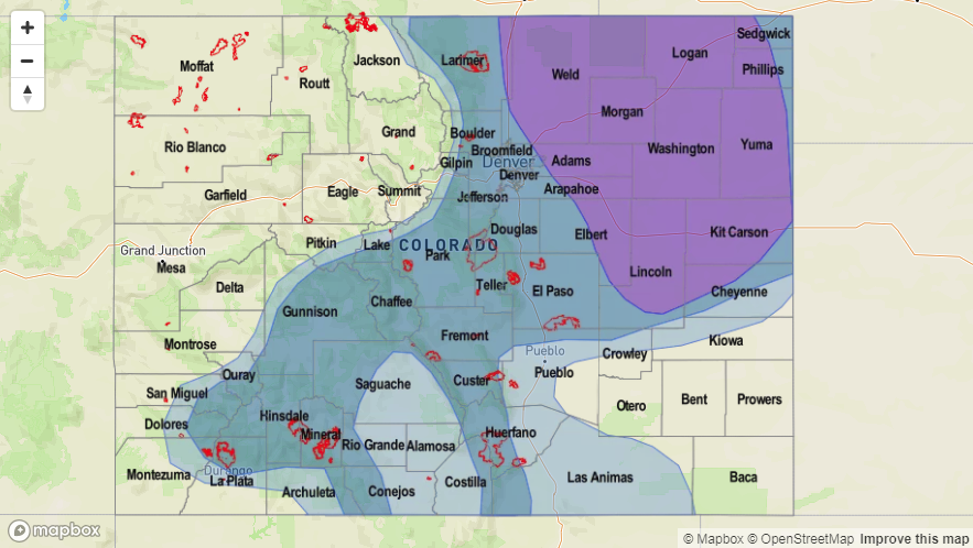
Elevated for afternoon, terrain induced thunderstorms and an overnight MCS over the Northeast Plains.
The high pressure to the west of Colorado begins to break down as the upper trough passes to the north of Colorado. As the trough passes, it will release numerous shortwaves that will rotate around the upper high. This will help kick off more widespread thunderstorms over the northern mountains. By the early evening, expecting some strong storms to move off the Cheyenne Ridge and northern Front Range into the Northeast Plains. Southeast flow at the low levels will bring abundant moisture into the region. With high moisture, an MCS will likely set up and bring heavy rainfall to the Northeast Plains and become sustained overnight thanks to help from the low level jet. High PW values will also continue over the southern high terrains. Thus, the flooding threat with the slow steering winds will stick around one more day before the ridge begins to build back to the west and dry out the atmosphere. Max 1-hour rain rates up to 1 inch are possible over the higher terrains with rain rates up to 2 inches/hour over the Northeast Plains.
Event #2: Friday (7/20) – Monday (7/23)
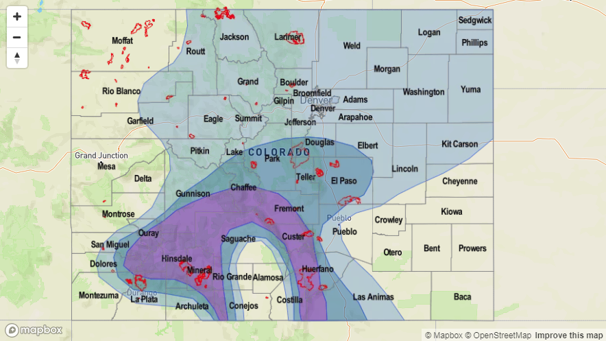
Elevated/No Apparent Threat as subtropical moisture returns to Southeast Colorado when the upper ridge shifts southeast.
The second event of this FTO period will mostly be for the Southeast Mountains and western high terrains. PW values just below 1 inch return for this weekend as the high shifts to the southeast and allows subtropical moisture to be pulled back into southern and western Colorado. Where the center of the high sets up will determine how far north the high PW values can return, so there is some uncertainty in the forecast at this time. Burn scars over the mountains will also be under the gun once again as rain rates greater than 0.75 inches/hour are likely. The slow moving nature of the storms will also increase the chances of flooding across all these regions. Threats include mud flows and debris slides over the higher terrains and flash flooding of small streams/low-lying roadways over the adjacent plains. A cold front looks to move through the region on Sunday, and if this happens, this will be the day with the greatest flood threat as it would moisten the lower levels and increase rain rates behind it.


