Issue Date: Monday, July 9th, 2018
Issue Time: 1:55PM MDT
Valid Dates: 7/10– 7/24

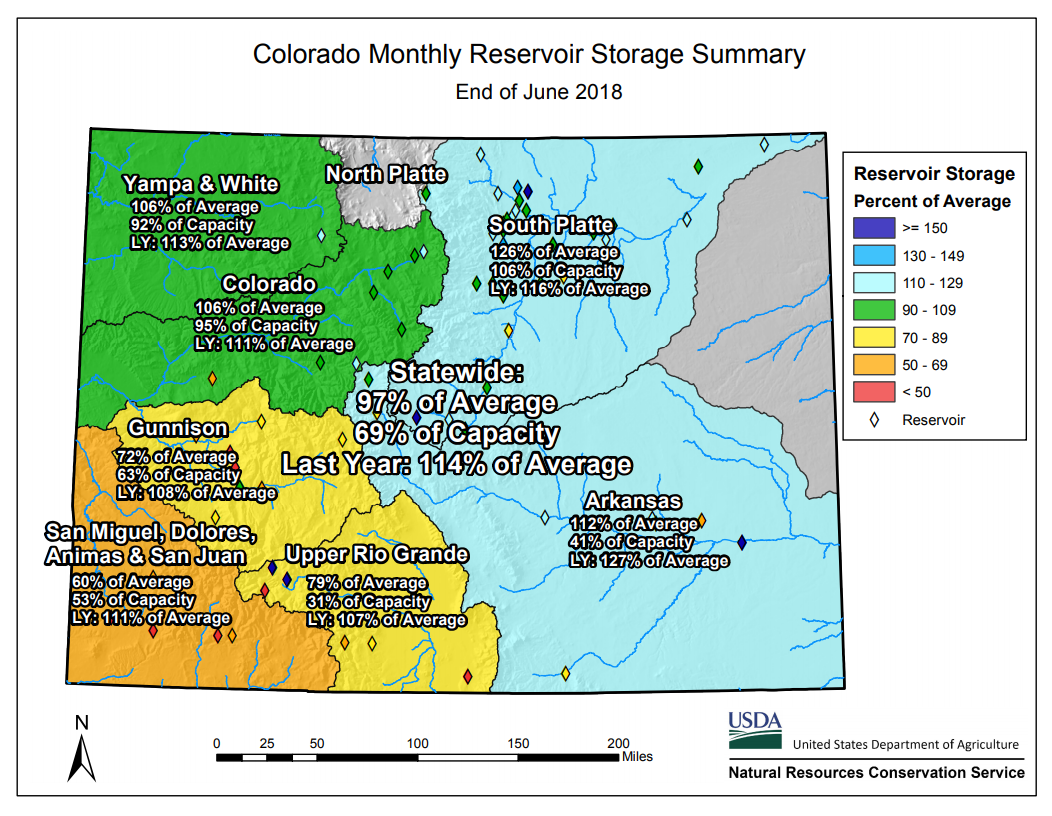
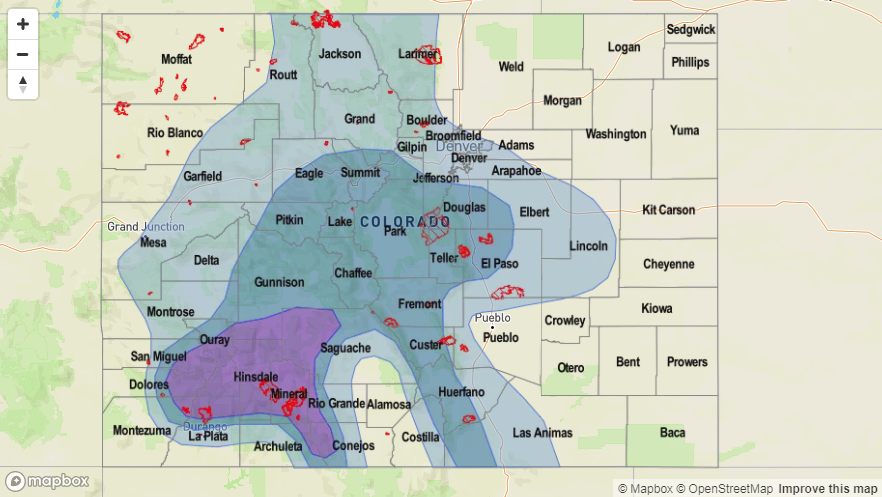
Before getting started on the FTO for this next period, let’s take a look a look back June’s climatology and the June 2018 Colorado Reservoir Storage Summary for the State of Colorado (source: HPRCC and NRCS). June was very warm compared to climatology with above average temperatures across the entire state. Most areas were 2-4F above average, with the warmest region over the Southeast Mountains and adjacent Southeast Plains. High temperatures were 6-8F above normal. As far as precipitation, the Southwest Slope and eastern San Juan Mountains received anywhere between 0.25 to 1 inch more than June climatology. Other areas that were above average for precipitation during June were the far Northeast Plains and northern Front Range. Elsewhere, precipitation was 5-25 percent of normal with the lowest percent of normal over the Southeast Mountains, Southeast Plains and Northwest Slope. Despite above average precipitation over the southeast corner of the state, reservoirs are anywhere between 60-80% of average. Reservoir storage at the beginning of May in this area was close to 100%, so quite a bit of water has been used. Hopefully the onset of the monsoon season will bring plentiful moisture to this area without triggering mud flows and debris slides over the burn scars. Elsewhere, storage remains high with most watersheds well above average and close to capacity. Statewide, Colorado is looking pretty good going into June (especially considering this year’s low snowpack) sitting at 97% of average. However, this is down 17% when compared to this time last year.
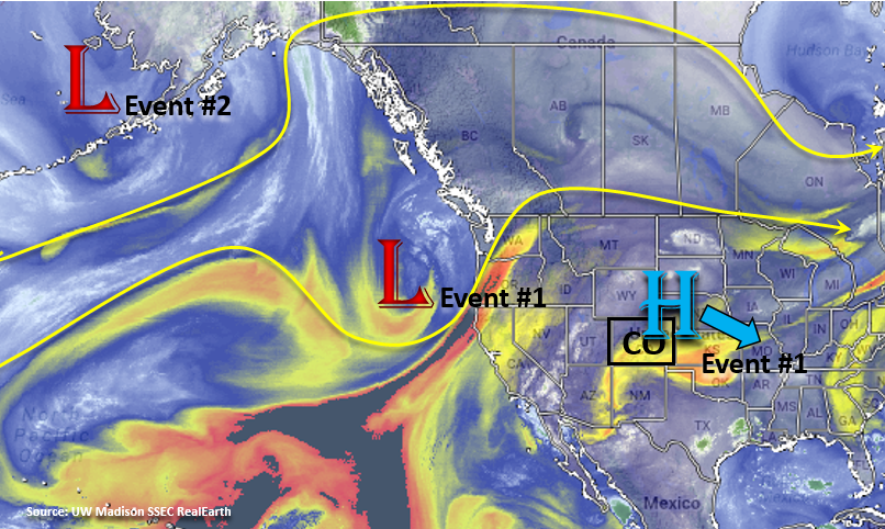
Moving back into the forecast, afternoon thunderstorms over the higher terrains with on and off access to subtropical moisture will define this next FTO period. Colorado will remain under a ridging pattern, which will bring warm temperatures the rest of this week. Models are hinting at a cold front moving through this weekend, which will be a welcomed respite from the heat should that forecast stay on track. Currently, the upper-level high pressure is sitting on the north side of Colorado and can be seen in the water vapor imagery below. The low pressure over the west coast will move northeast starting tomorrow, which will shift the ridge axis to the east. Then by Wednesday, the center of the high pressure system will be located over MO/AR and spin in place through Friday. These two features will define Event #1. After Event #1, the ridge will begin building back to the west. A second upper trough pushes through the northern US starting on Saturday afternoon (Event #2), which will make the upper flow more zonal and maybe even give the flow more of a northerly component. The position of the high pressure at this time (west of Colorado), is expected to keep the higher moisture south. There is quite a bit of uncertainty with the forecast after this weekend due to not having high confidence in the exact positioning of the high pressure, which will directly affect the moisture return.
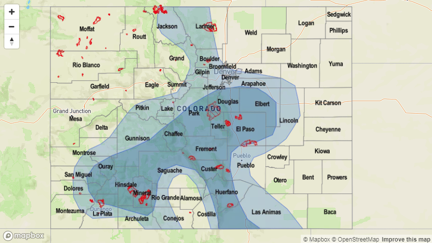
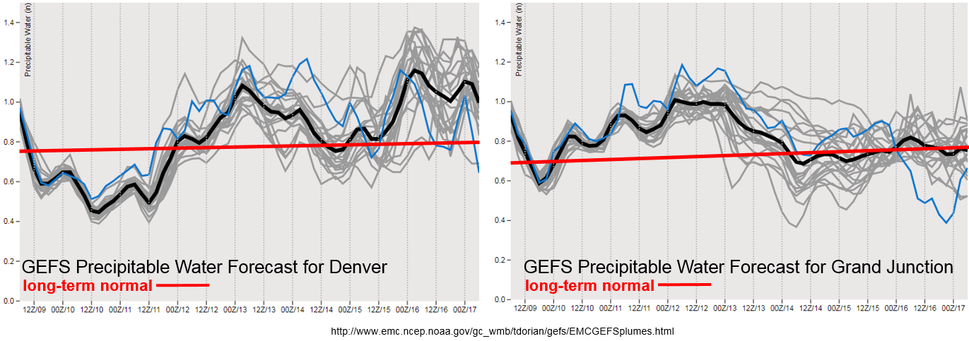
Precipitable Water (PW) over Colorado should be high enough over the next week to allow afternoon upslope flow to develop scattered thunderstorms over the higher terrains each afternoon. The daily location of greatest rainfall and highest coverage is hard to predict more than a couple days out, so check back to the FTB for details. By mid-week, PW jumps quite a bit both east and west of the Continental Divide. The moisture returns more quickly to the southwest corner/western Colorado, and then as the high pressure continues to spin to the east, moisture returns to eastern Colorado. This monsoon flow, will create an Elevated Flood Threat at the end of this week. Rain rates will be high enough that if storms track over recent burn scars in the Southeast and San Juan Mountains, mud flows and debris slides could occur. Moisture decreases after Friday west of the Divide, so not as worried about burn scars this weekend. Sunday afternoon, PW increases east of the Divide. Once again, slow moving thunderstorms and high moisture content of the atmosphere will bring another Elevated Flood Threat to the Front Range, Southeast Mountains, Palmer Ridge and adjacent plains Sunday – Tuesday. This will be especially true if the passage of the cold front moistens the lower levels of the atmosphere later this weekend.
Below we describe the two identified precipitation event of this FTO in more detail.
Event #1: Tuesday (7/10) – Friday (7/13)
Elevated/No Apparent Threat for afternoon, terrain induced thunderstorms with subtropical moisture.
With the high pressure setting up to the east of Colorado, the ridge axis will allow subtropical moisture to return to the state. At first, the moisture will move into southwestern and western Colorado, but by Thursday, the subtropical moisture will have made its way east of the Continental Divide. Despite on and off again moisture, there should be enough moisture to allow for thunderstorm development each afternoon with upslope flow over the higher terrains. With the exception of Friday, not expecting thunderstorms over the eastern plains. With PW greater than 1 inch later this week, the slow moving storms are expected to produce flash flooding. Over the mountains, threats include mud flows, debris slides and local stream flooding. This is especially true if any of these storms track over recent burn scars. Over the adjacent plains, highly impervious urban areas may experience street flooding, field ponding and local stream flooding. For specific details about coverage of the thunderstorms each day and rain rates, please check back to the FTB posted daily by 11AM.

Event #2: Sunday (7/15) – Tuesday (7/17)
Elevated/No Apparent Threat as subtropical moisture returns to Southeast Colorado.
The second event of this FTO period will mostly be for the Southeast Mountains, Palmer Ridge, Southern Front Range and the adjacent plains. PW values greater than 1 inch are currently forecast return at the beginning of next week. Where the ridge sets up will determine how far north the high PW can return, so there is some uncertainty in the forecast at this time. There is still a chance for some more isolated showers over the San Juan Mountains, so this will be monitored closely as it will only take 0.25-0.5 inches/hour to trigger flash flooding over the recent burn scars. Burn scars over the Southeast Mountains will also be under the gun once again as rain rates up to 1 inch/hour are possible. The slow moving nature of the storms will increase the chances of flooding over the areas they track. Of course, these high rain rates all depend on if PW returns to the values predicted by the GEFS. At this time it is impossible to predict the exact location of the flooding, though heavier rain should favor the Southeast Mountains, Raton Ridge and Palmer Ridge.