Issue Date: 7/12/2018
Issue Time: 9:40 AM

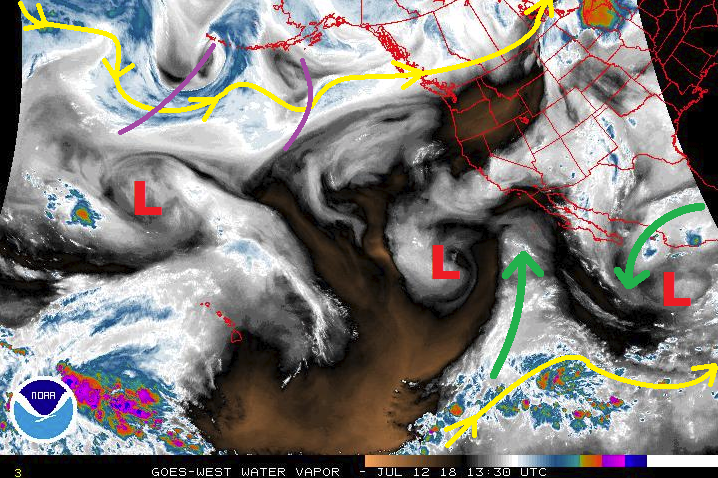
A “chaotic weather regime” is the best way to describe the weather pattern over the Pacific, and this has the negative effect of adding extra uncertainty to the extended forecast. Here in Colorado, the best way to break down the next 15 days will be to discuss the meandering upper-level high, which will take turns opening Colorado to subtropical moisture, upper-level disturbances, cool fronts from the north, and periods of hot summer weather. This FTO period kicks off quickly, with Event #1 slated for the first 4 days (Friday, July 13th – Monday, July 16th). The upper-level high pressure will begin to build over the western US on Friday, which will allow for the each day to be drier than the previous day, as subtropical moisture gets shunted south of the state. Even so, there will be enough residual moisture trapped underneath the ridge to generate daily showers/thunderstorms, with the bulk of activity focused over the higher terrain. If the upper-level ridge centers far enough southwest, northwesterly flow will return to eastern Colorado, allowing the influence of disturbances aloft (purple lines on the water vapor image) and surface cool fronts to bring additional support for thunderstorms, which would increase the precipitation expected. This will be monitored closely.
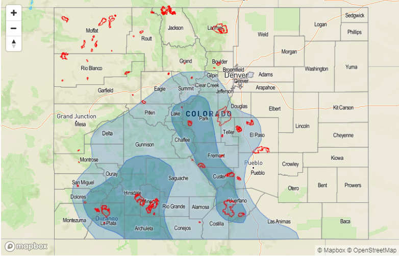
At any rate, due to the number of recent/ongoing fire burn areas scattered across the higher terrain, an Elevated Flood Threat has been issued for Event #1. It will be important to monitor the daily FTB forecasts; they will provide the most up-to-date and specific flood threat information. By late Monday, the upper-level high is expected to shift back over Utah/western Colorado, which will help suppress thunderstorm activity and allow the state to dry through Thursday. Daily isolated, high-based showers/weak thunderstorms will still hug ridge tops during this time frame, as is typical of the Colorado summertime, with the result being more gusty winds than rain.
Event #2 will make its appearance beginning on Friday, June 20th, as an upper-level disturbance flattens the ridge. This elongated high pressure will open Colorado to influence from cool fronts moving in from the northwest in association with any additional shortwave disturbances, with drier westerly flow aloft. While this type of scenario will generally be unfavorable for storms along/west of the Continental Divide, it will be favorable for storms to the east as upslope flow behind cool fronts will transport low-level moisture from the Great Plains into eastern Colorado. This period should be watched for the return of a few strong-to-severe storms capable of heavy rain from the foothills to the eastern border. Unfortunately, the current large-scale pattern we find ourselves in lends itself to more uncertainty in the medium- and long-range forecasts, so there isn’t enough confidence for any flood threat designation. Event #2 will continue through the weekend, ending Monday, July 23rd.
After Event #2 comes to a close, upper-level high pressure will once again strengthen across the region, allowing Colorado to heat up and dry out as we head towards August. Daily afternoon/evening thunderstorms over/near the higher terrain will likely still be in the forecast, but that should be about it. We will keep an eye on this time period as it draws nearer, and will provide an update during Monday’s FTO.
Event #1: Friday (07-13-2018) through Monday (07-16-2016)
Elevated Flood Threat Mainly Due to Recent/Ongoing Fire Burn Areas
An upper-level ridge will try to build over the western United States, drying out Colorado little by little over the event period as subtropical moisture gets shunted south of the state. However, residual moisture and precipitable water values that are slow to come down will aid the development of daily afternoon/evening thunderstorms, mainly over/near the higher terrain. We will be monitoring closely the eventual position of the upper-level high; if it is located far enough south/southwest, northwest flow aloft, surface cool fronts, and increased moisture transport from the Great Plains into eastern Colorado will bring the threat of heavy rain from the Front Range to the eastern border. It will be important to stay up-to-date with the daily FTB.
Recent and ongoing fire burn scars are the main culprit behind the Elevated Flood Threat designation.

Event #2: Friday (07-20-2018) through Monday (07-23-2018)
No Apparent Flood Threat due to Uncertainty in the Weather Pattern
The position and elongation of the upper-level high will open Colorado to the influence of passing upper-level disturbances and cool fronts from the north, making this period a focus on eastern Colorado. Upslope flow behind any cool fronts will transport Great Plains moisture into eastern Colorado and back into the Front Range, setting the stage for the return of strong-to-severe thunderstorms capable of heavy rain. Unfortunately, uncertainty in the placement of large-scale features such as the upper-level high leave uncertainty too great for a precipitation map and flood threat designation. We will closely monitor this time frame, and have an update in Monday’s FTO.