FTO 08-04-2022: High Flood Threat This Weekend Before A Break In Rainfall Activity

Issue Date: Thursday, August 4th, 2022
Issue Time: 3PM MDT
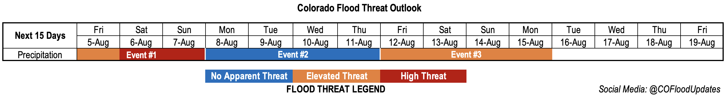
Valid Dates: 8/5 – 8/19

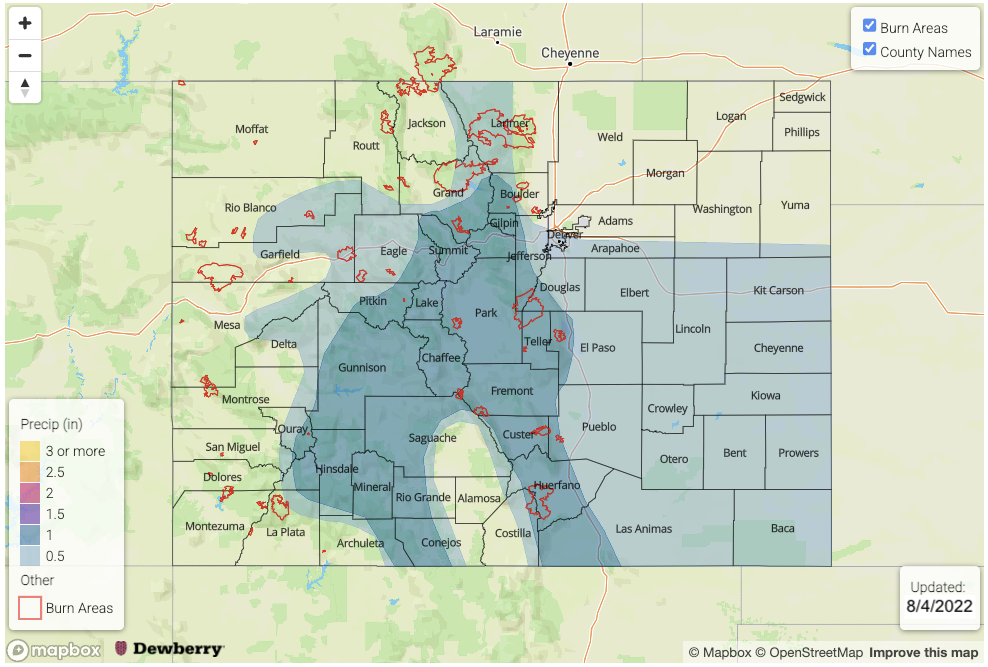
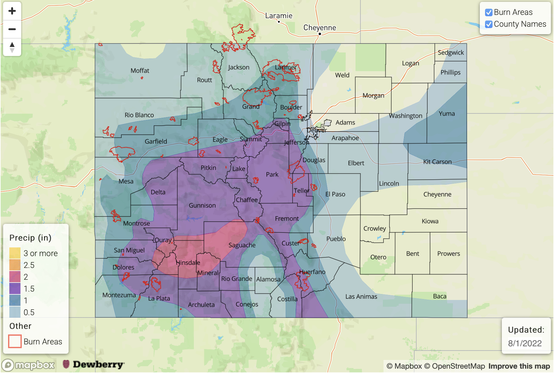
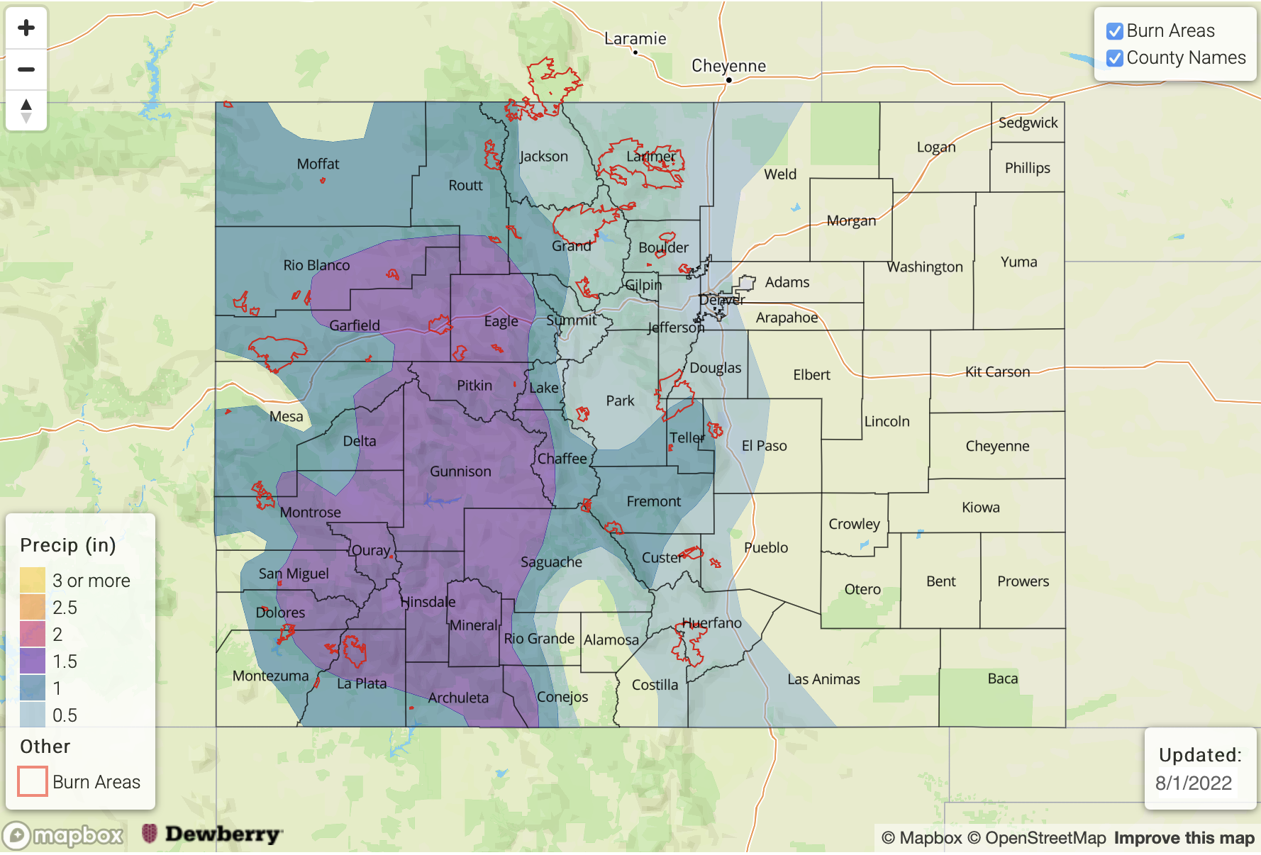
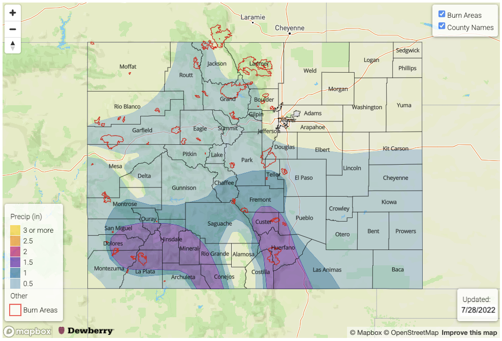
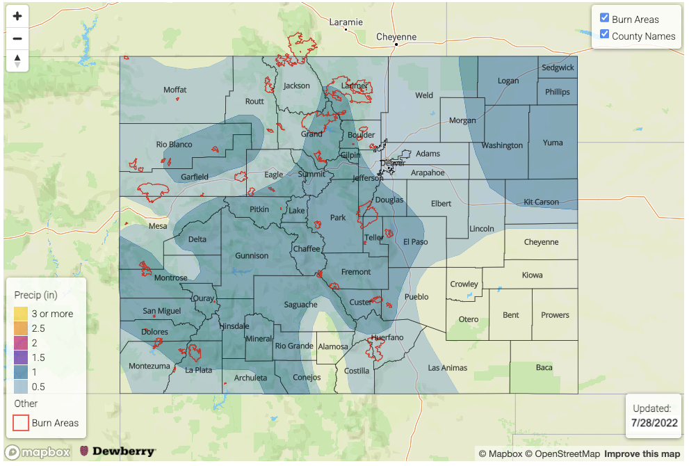
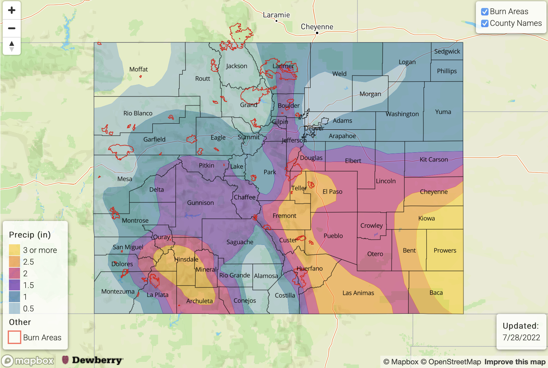
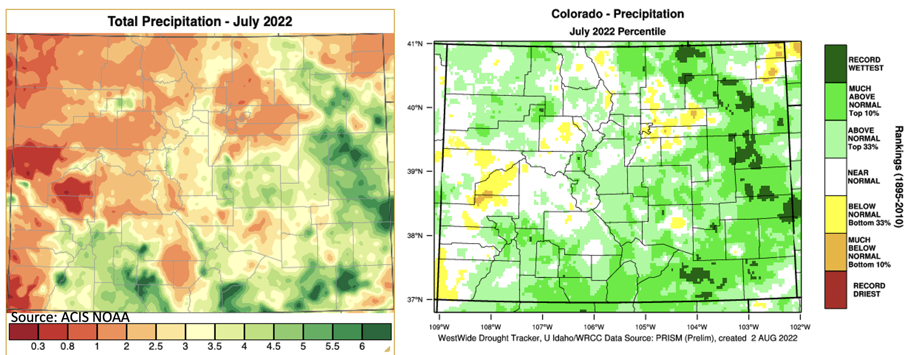
Below is a quick recap of precipitation from July using PRISM data. On the left is the estimated total precipitation for the month (inches), and on the right is the percentile of precipitation. Outside of portions of the western central and southern valleys, precipitation was generally above normal to much above normal statewide, and for portions of the eastern plains, July was the wettest on record. The one exception for the eastern plains is Sedgwick and Phillips Counties, which are still experiencing Extreme Drought conditions and recorded much below normal precipitation. As we’ve been monitoring in the SPM and FTB, it was a very wet month for the southern Southeast and San Juan Mountains with maximum estimated precipitation coming in at over 6 inches. A CoCoRaHS station outside of Pagosa Springs measured 5.18 inches for the month. As expected, local rivers are running higher than usual for this area with increased runoff from saturated soils, and gauges are showing well-defined spikes in streamflow associated with each day’s rainfall. Head on over to the DWR site to check them out.

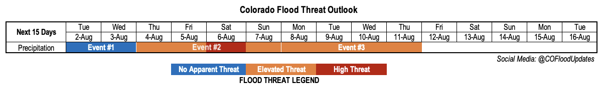
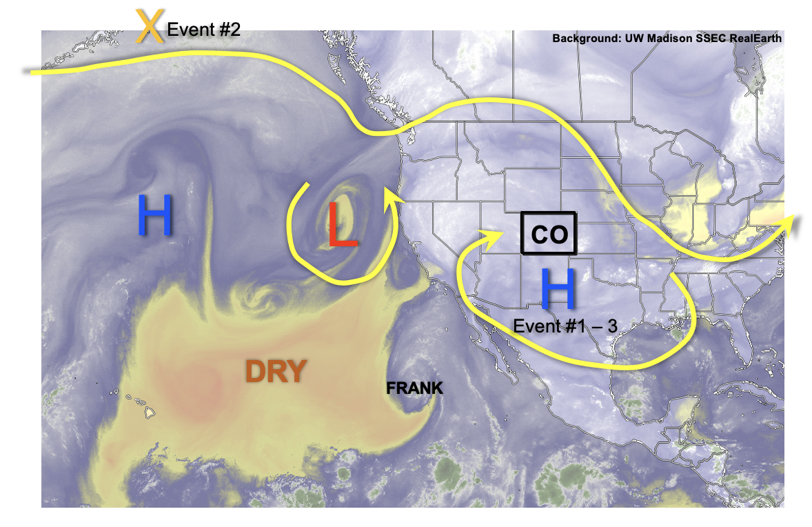
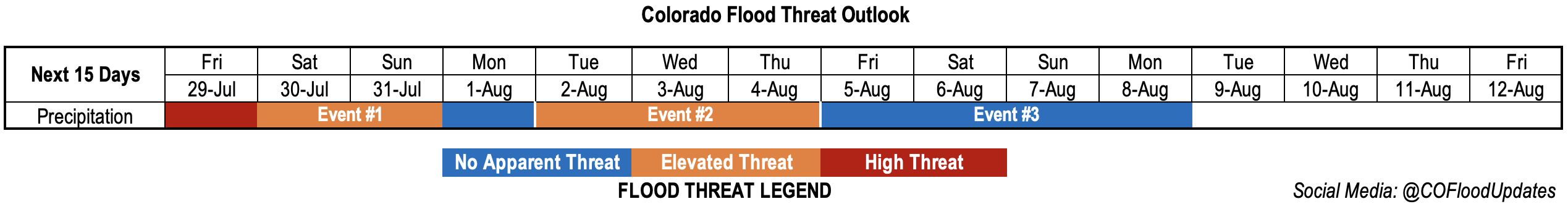
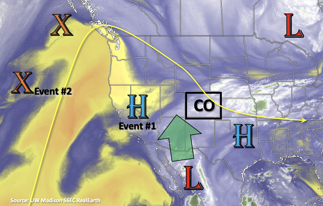
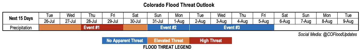
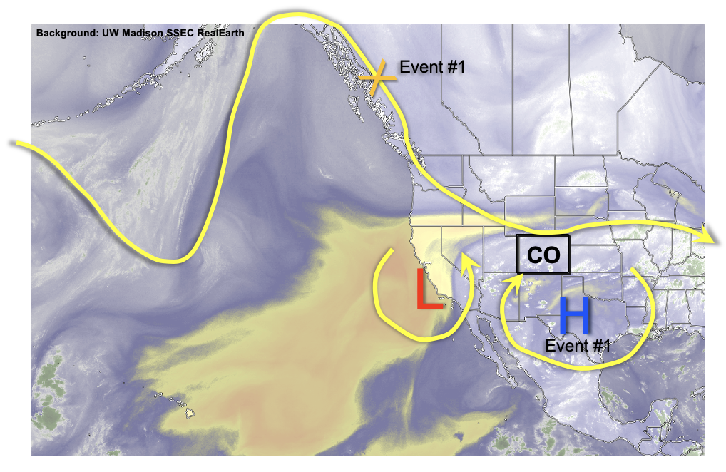
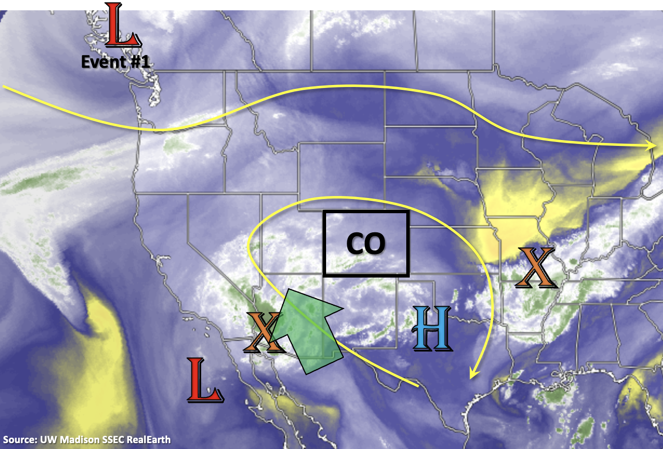
Heading into this next Outlook, it will remain very active on the rainfall front through this weekend (Event #1) before a nice break in precipitation and heavy rainfall chances next week (Event #2). Driving this weekend’s precipitation event will be an incoming trough that should displace the ridge axis eastward. In turn, this and a Low off the west coast will help to pull the subtropical moisture plume and mid-level energy marked below northwards into western Colorado first, and then into eastern Colorado later this weekend. Following Event #1, drying is expected for a couple days, although residual moisture, south, will likely continue to produce diurnally driven storms over the high terrain. Guidance is hinting at another monsoon surge after that (Event #3), so we aren’t quite done with this long rainy season yet. Here are some quick stats about Colorado’s heavy rainfall threat. Since mid-June, there have been 37 threats issued, and the current FTB threat streak is at 13 days with additional threats likely continuing over the next 3 days.

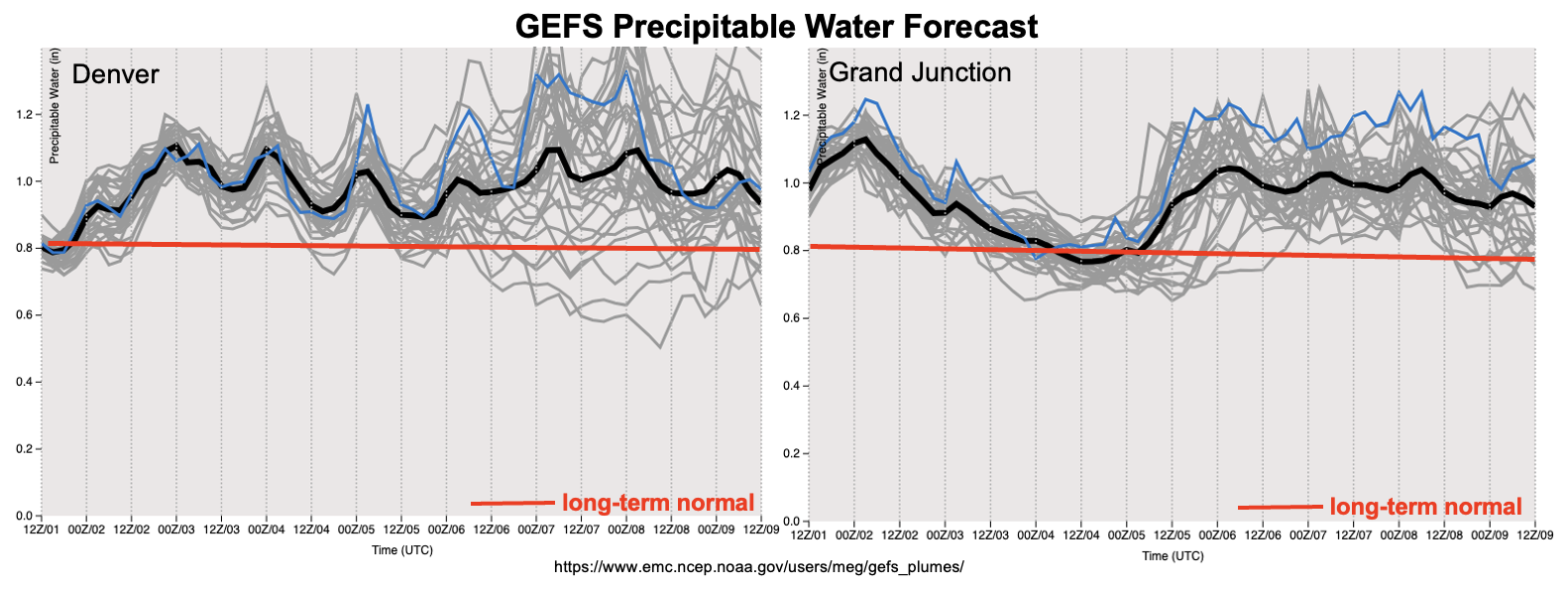
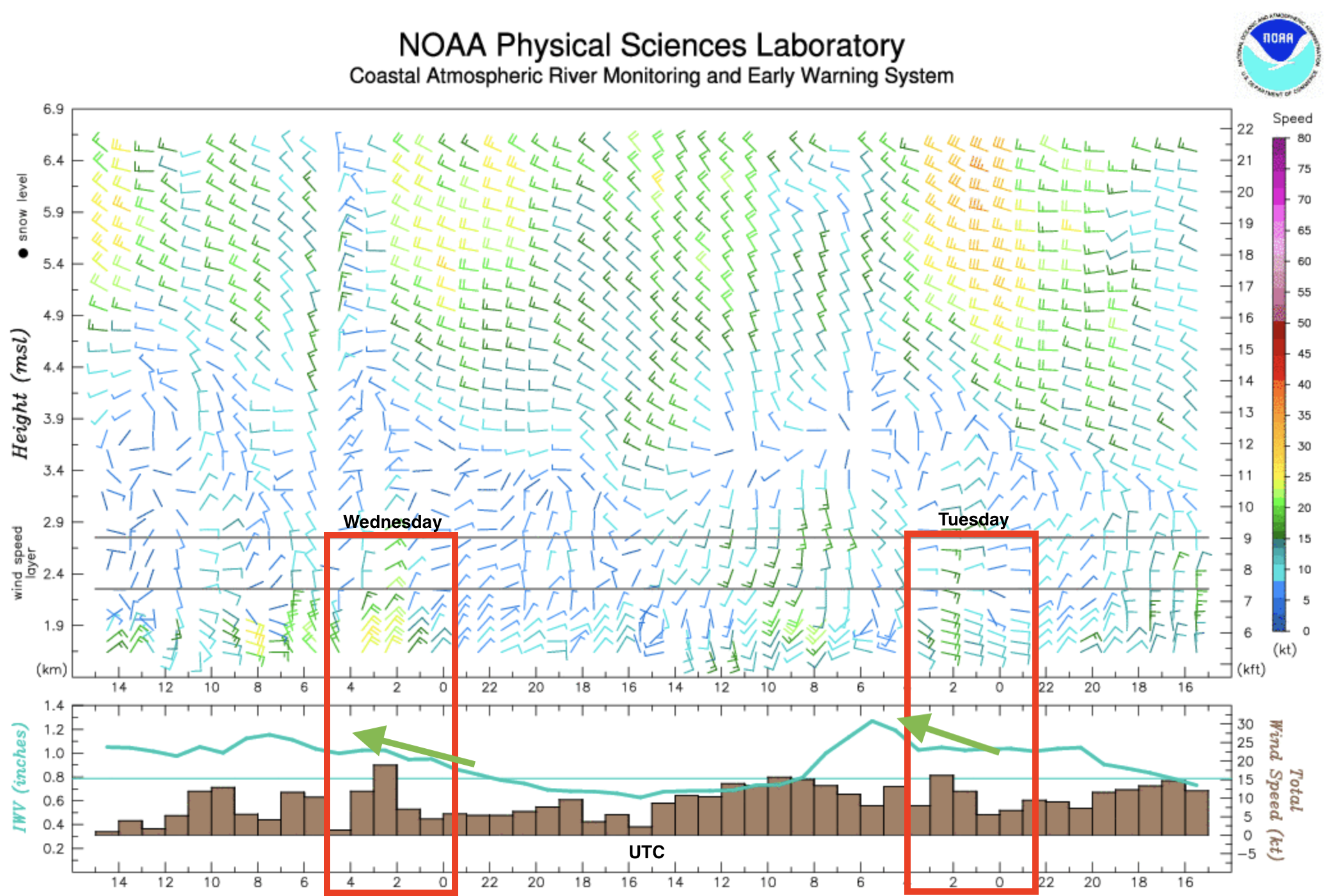
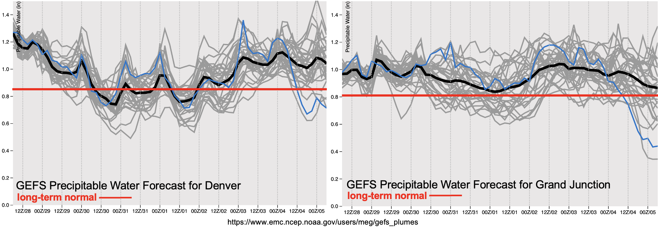
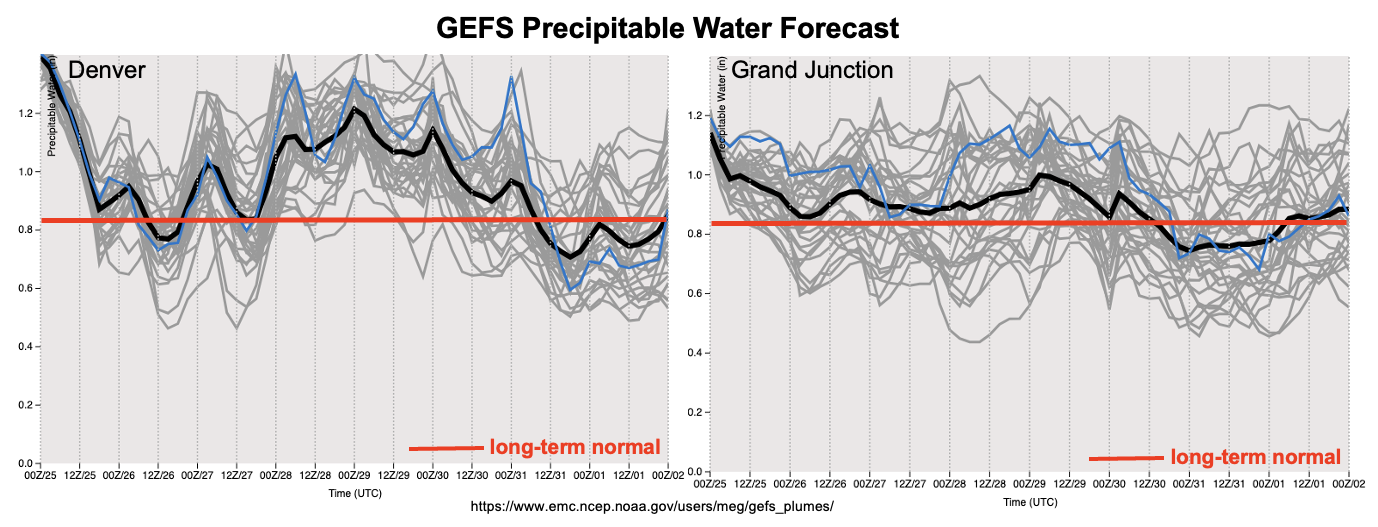
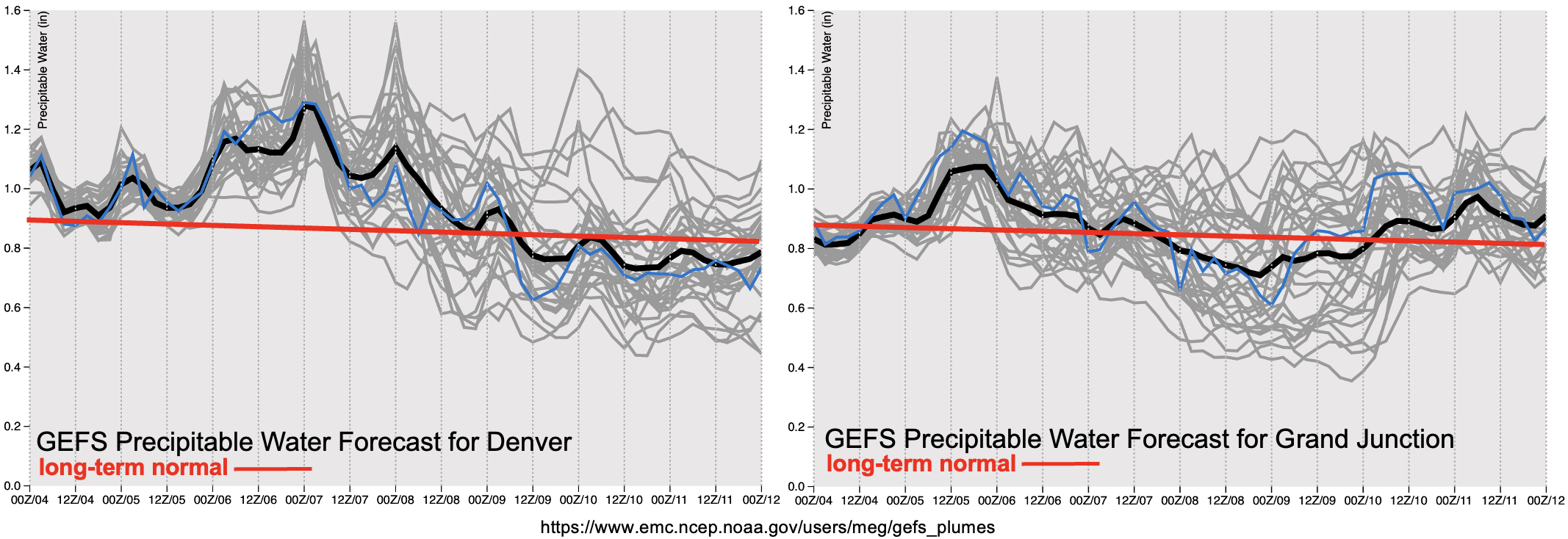
A High threat has been issued for Saturday and Sunday with above average PW values forecast statewide. The drying trend early next week can be seen by the downward trend in the middle of the PW plots below. Although moisture does look to decrease, PW values are likely to remain right around average. Although some capping is expected next week, the isolated storms that are able to pop over the high terrains (most likely south), may still be able to produce a flood threat with steering flows. Be sure to tune back into the FTO on Monday as there will likely be more clarity as to how much of a break in heavy rainfall there will actually be.

Event #1: Friday – Sunday (8/5 – 8/7)

Above average moisture, increased dynamics and saturated soils will cause a High flood threat to be issued for this weekend.

This event will first begin over western Colorado and shift into eastern Colorado with the passage of a trough to the north. The flood threat on Friday should continue to be in the 30-minute to 1-hour range from storms, but some longer duration, moderate rainfall may also be possible this weekend with the passage of a front. Depending on the timing of the frontal passage, a couple of severe storms may be possible with the main threat being strong outflow winds. As for potential flood impacts, saturated soils further south, may continue to cause rises on local rivers and creeks and there is an increased threat for mud flows and debris slides over steeper terrains. Over the lower elevations and valleys, road flooding and field ponding will be possible.

Event #2: Monday – Thursday (8/8 – 8/11)

No Apparent flood as PW decreases and rising heights help to suppress precipitation chances.

Widely scattered to scattered storms will be likely over the high terrain during this period with the best coverage over central western Colorado and the southern mountains. With the High building over western Colorado, increased subsidence and capping should keep the adjacent plains and valleys dry. Max 30-minute rain rates up to 0.5 inches will be possible, so at this time, there is No Apparent flood threat.

Event #3: Friday – Monday (8/12 – 8/15)

Guidance is hinting at a return of monsoon moisture, so an Elevated flood threat has been issued with highest precipitation amounts forecast over the high terrain.

The monsoon season looks to continue with another monsoon moisture surge possible over the western Colorado and the mountains at the end of next week. Rain rates could easily reach the 1 inch in 1 hour threshold with PW anomalies likely increasing to above average values. Tune back into the FTO on Monday as the details of this next event will inevitably evolve.

FTO 08-01-2022: Moisture Abounds; Flood Threat Continues

Issue Date: Monday, August 1st, 2022
Issue Time: 3PM MDT
Valid Dates: 8/2-8/16

As mentioned in the July 25th Outlook, there were 44 straight days of rain somewhere across Colorado. Well, fast forward one week and we can safely bump that number up to 51 straight days. And fast forwarding at least 7-10 more days within this Outlook, that streak will easily continue to play out.

It has certainly been a memorable monsoon already, and it has been many years since we have seen this kind of consistency in the flow of above normal moisture into our state. As shown in the water vapor image, below, this Outlook is a status quo of the past 45 days or so. The circulation of the monsoonal ridge will continue to wobble across the western North America. But, it will be centered primarily to the south and east of Colorado. With plenty of moisture available over the eastern tropical Pacific, moisture here at home will continue to be above normal to, at times, near record level (see forecast PW plumes, below). As an interesting aside, tropical cyclone activity over the eastern Tropical Pacific is currently almost twice the normal value (compared to well below normal over the western Pacific), possibly helping explain our abundance of moisture here.

To start this Outlook, we see a relative lull in the flood threat as moisture will dip just a bit (Event #1), which combined with quicker steering flow will promote at least scattered storms but limited heavy rainfall potential. But by later this week, a monsoonal surge will re-ignite the heavy rainfall mainly over the higher terrain. An Elevated threat is warranted over a prolonged stretch (Event #2). The passage of a Pacific cool front (currently located over the Gulf of Alaska) looks to enhance the heavy rainfall ingredients so that a High flood threat looks possible though the exact timing is uncertain. With plenty of antecedent precipitation, soils will be particularly vulnerable not only to enhanced runoff rates, but also mud flows and debris slides. This provides extra confidence in the issuance of a High flood threat.

The pulse of monsoonal moisture responsible for Event #2 looks to carry further north. However, in its wake, above normal moisture should continue through mid next-week, leaving an Elevated flood threat for the higher terrain. At this time, the threat looks to shift further west towards the Utah border as more subsidence and relatively drier should curtail the threat over eastern Colorado.

Throughout this Outlook, temperature anomalies will persist in a similar fashion as the past month or so: most of western Colorado should be cooler than normal due to the presence of storms and frequent cloudiness. More variations in temperature is likely for eastern Colorado as very hot days are mixed with more seasonable days following cool front passages, and also when storms are able to make it off the higher terrain.

The identified precipitation events are described in more detail below.

Event #1: Tuesday – Wednesday (August 2 – August 3)

Scattered High Terrain Storms, But No Apparent Flood Threat

Widely scattered to scattered showers and storms are expected daily during the afternoon and evening. The best coverage will be over the western and central higher terrain. Max 30-min rainfall up to 0.5 inches is currently expected. However, outside of fire burn areas, flooding looks unlikely at this time.

Event #2: Thursday – Sunday (August 4 – August 7)

Mainly Higher Terrain Elevated/High Flood Threat; Uncertainty For Lower Elevations

An increase in storm coverage should begin on Thursday over the southern higher terrain, then spread northward by Friday. During this period, the flood threat appears to mainly reside in the 30-60 minute duration where 1.0 inch and 1.5 inch intensity is possible, respectively.

By Saturday, a frontal passage from the north is expected. Depending on the exact setup with timing, moisture availability and steering flow, a 36-48 hour period of enhanced threat will be possible over the Front Range southward through the Southeast Mountains. Heavy rainfall in the 3-6 hour duration looks possible, with max 6-hour accumulation exceeding 3 inches possible. Additionally, precipitation could extend well into the evening and overnight hours, adding to the impact. Given enough heavy rainfall coverage, along with the growing importance of wet soils, this could translate into a riverine flood threat.

The flood threat for the eastern Plains looks limited at this time.

The next Outlook should have more details on this Event.

Event #3: Monday – Thursday (August 8 – August 11)

Plenty Of Storms Expected Daily For Higher Terrain; Elevated Flood Threat

With moisture dialing back a bit, afternoon and evening storms are likely to drop in coverage but still be of at least the scattered variety. The best coverage looks to be over the western and central high terrain. Maximum intensity of 0.8 inch/30 minutes and 1.2 inch/60 minutes supports an Elevated flood threat for the risk of isolated flash flooding, debris slides and mud flows.

FTO 07-28-2022: Brief Break In Rainfall Possible Early Next Week, But High/Elevated Flood Threat Heading Into This Weekend

Issue Date: Thursday, July 28th, 2022
Issue Time: 2:15PM MDT
Valid Dates: 7/29 – 8/12

There have been some significant rainfall events across the state over the last couple of days, which include the Denver Metro area. Below is an image from the wind profiler at Platteville, CO (east of Longmont). A wind profiler detects how the wind’s direction and magnitude changes from the surface to 6km upwards. Below in the red boxes are the near-surface evening winds on Tuesday (right) and Wednesday (left). While model guidance was somewhat bullish on whether or not convection would fire over the Front Range, the profiler shows very strong upslope flow from the surface to 3km, which helped to initiate storms. The profiler also shows Integrated Water Vapor (IWV) on the bottom, which shows an increasing trend (green arrow) coinciding with the intensification of the upslope flow. With PW values over an inch and slow steering flows aloft the last couple of days, it is no wonder that the storms have dumped extremely heavy rainfall in their cores. The one saving grace is that the thunderstorms have been more isolated over the Denver Metro area, which has helped to reduce the overall flooding impacts.

The heavy rainfall threat will continue for this next FTO period as monsoon moisture continues to be syphoned northwards as shown by the green arrow in the water vapor imagery below. It is important to note that several areas have seen days of rainfall at this point (head over to the SPM and check out the 72-hour option), which could increase the localized flood threat if convective storms develop during the afternoons and evenings. This is especially true over portions of the southern high terrains, and these antecedence conditions will be tracked closely in the daily FTB.

During Event #1, the High will begin to rebuild to our west. This should keep moisture elevated across southern and western Colorado through this weekend. A small downtick in moisture, and thus storm activity, is anticipated on Monday, but residual moisture over the western high terrains will likely help produce some isolated afternoon and evening rainfall. Event #2 begins as a shortwave moves inland over the Pacific Northwest and displaces the ridge axis eastward, which should create another monsoon surge. Flow aloft is forecast to turn westerly during this period with a chance of a cool front dropping through the plains, which will should help return rainfall to the area. Soon after Event #2, the ridge begins to build back over the western US (Event #3), pulling moisture northward. At this time, it looks like the highest PW values should be our west, so there is No Apparent flood threat issued. As for high temperatures this week, by Monday, above average temperatures return to most areas, and they should persist over the eastern half of Colorado through the end of the week.

PW plumes below show extremely elevated moisture over the state with the long-term normal (red line) already at or around 0.8 inches. A High flood threat has been issued for tomorrow with an Elevated threat issued through this weekend. The downtick in moisture mentioned above can be seen both over central western and eastern Colorado, but it is likely higher PW values will hang around across the southern border with little change to the synoptic setup or mixing out of the boundary layer moisture. PW begins to climb again over eastern Colorado on Tuesday with the eastward displacement of the ridge, and an Elevated flood threat has been issued for Event #2.

Event #1: Friday – Monday (7/298/1)

Saturated soils mixed with convection is likely across the southern mountains & will cause a one-day High flood threat to be issued.

As mentioned above, soils are likely very saturated over the southern portion of the state after multiple days of rainfall. Thus, it could take lower rain rates to produce mud flows, debris slides and excessive runoff tomorrow. With max 1-hour rain rates up to 1.25 inches possible and widespread areas potentially receiving at least another inch of rain over the San Juan and Southeast Mountains, a High threat has been issued. Additionally, max 1-hour rain rates up to 1.75 inches may be possible over the western portions of the elevated ridges, which could cause more isolated flooding. The threat for flooding somewhat decreases over the weekend, but isolated downpours could still occur over the southern high terrains, so an Elevated flood threat has been issued. Monday looks to be a quieter weather day with only isolated to widely scattered storms forecast over the western high terrains and southern Southeast Mountains.

Event #2: Tuesday – Thursday (8/28/4)

Elevated flood threat is issued as the next monsoon surge occurs over western Colorado and spills eastward under westerly flow aloft.

Initially, the flood threat is likely to be over the western high terrains with some stronger thunderstorm activity possible over the Northwest Slope and Northern Mountains. By Wednesday, most of the mountain areas should expect scattered to numerous storms redevelop. Thursday is looking like the most active day with numerous to widespread storms over the state. Increasing westerly steering flows and perhaps a weak boundary may return storm chances to the Northeast Plains and Palmer Ridge. Be sure to tune back into the FTO on Monday as it may be possible for a partial upgrade for this event.

Event #3: Friday – Monday (8/58/8)

No Apparent flood threat with the ridge building northward over western Colorado.

Still too early to how exactly this event will unfold, but with the ridge axis rebuilding itself over the western US, it is likely that monsoon moisture will move northward with it. Currently, it looks like the largest PW anomalies will stay west of the state, but that forecast could easily change as the event nears. At this time, there is No Apparent flood threat, but worth mentioning there’s a high likelihood for this long monsoon season to continue.

FTO 07-25-2022: A Very Busy Week For Heavy Rainfall Ahead

Issue Date: Monday, July 25th, 2022
Issue Time: 2:45PM MDT
Valid Dates: 7/26-8/9

Shown below is the maximum daily estimated precipitation across Colorado since our forecast season started on May 1st. As we can see, it has been a busy season with 44 consecutive days of rainfall now observed since the early (but welcome!) start to the 2022 monsoon season. Moreover, as shown in the magnitude of the bars below, heavy rainfall (roughly measured by the 1 inch value) has been a recurring theme. Fortunately, the heaviest accumulations have been rather isolated in space, precluding significant flooding. Until now, that is. The past 24-hours of widespread heavy rainfall activity has been a foreshadowing to a very busy week ahead for Colorado.

As shown below in this afternoon’s water vapor imagery, we will generally not have to stray far from home to see the main players in this week’s atmospheric circulation. By far the most important piece is the infamous upper-level ridge (often termed the “monsoonal ridge”). Anytime this feature is located east of Colorado, we are usually under an increased threat of heavy rainfall. The reason for this is due to the clockwise flow around the high pressure, deep subtropical or even tropical moisture can easily work northward into the Four Corners. Such will be the case over the next ~5 days or so. PW will gradually increase from the 0.9 – 1.3 inch range today to as high as 1.7 inches along our KS border by late Thursday (see forecast PW plumes, below)! Thus, we expect a prolonged period of heavy rainfall (Event #1) that will impact most of the state.

An Elevated flood threat is warranted for Tuesday and Wednesday as heavy rainfall will generally stay limited to the 30-60 minute duration. By Thursday, however, things turn interesting as a moist cool front drops south out of Canada (see “X” in the water vapor image above). A stalled frontal boundary will likely setup somewhere over eastern Colorado. To the north of this boundary, weak subsidence and limited instability will keep rainfall relatively light. This looks to be the case over the Northwest Slope, though the Northeast Plains may also fall into this category. Further south, however, with plenty of moisture, slow steering flow and sufficient instability, very heavy rainfall will be possible. In addition, there will be the chance of a prolonged period of heavy rainfall in the 3-6 hour duration, possibly longer, both Thursday and Friday. With antecedent wet soil conditions becoming more of a factor in limiting infiltration, runoff will be very efficient. This warrants a High flood threat for Thursday and Friday.

Notable drying and warmer weather is expected in the wake of Event #1, so that by Sunday, we stand a chance of seeing our first dry day statewide since June 10th. Thereafter, there is once again signs of another monsoonal moisture push, though at this time enough disagreement in guidance precludes a flood threat.

The identified precipitation events are described in more detail below.

Event #1: Tuesday – Saturday (July 26 – July 30)

Elevated Flood Threat Initially, With A High Threat Expected Later In The Week

Mainly higher elevation showers and storms are expected on Tuesday and Wednesday with 30-60 minutes of heavy rainfall expected. An Elevated flood threat is warranted with the chance of flash flooding, debris slides and mud flows. Some spillover of storms is anticipated into the Northeast and Southeast Plains, though at this time, flooding is not anticipated in these lower elevations.

By Thursday and Friday, almost all of the the higher terrain, especially east of the Continental Divide, will be under a threat of heavy rainfall mainly in the 1-3 hour duration. Max 3-hour rainfall approaching 2.5 – 3 inches could occur for elevations above 6,000 feet. Further east, storms are expected to grow into large complexes by the late afternoon. Heavy rainfall of 3-6 hour duration looks possible over mainly the Southeast Plains, though it’s possible the Northeast Plains will also be impacted. At this time, max 6-hour rainfall exceeding 4.5 inches looks likely at least over isolated parts of the Southeast Plains. In addition, the widespread nature of the heavy rainfall suggests a riverine flood threat will exist though mainly for smaller and medium-sized basins. A minor flood wave could certainly occur on the Arkansas River, but at this time it appears the main impacts at this scale will stay on the KS side of the border.

Conditions will begin to quiet down by Saturday, though an Elevated threat is still anticipated mainly for 30-60 minutes of heavy rainfall over the higher terrain of central and southern Colorado.

Event #2: Sunday – Monday (July 31 – August 1)

General Lull In Precipitation With Isolated Storms Along NM Border; No Apparent Flood Threat

Isolated storms are expected over the San Juan Mountains and Southeast Mountains on Sunday, with some northward increase possible into the Central Mountains by Monday. Rainfall amounts are expected to stay below 0.5 inches.

Event #3: Tuesday – Friday (August 2 – August 5)

Some Monsoon Moisture Returns, But No Apparent Flood Threat At This Time

Shower and storm coverage looks to increase into the widely scattered to scattered variety by Tuesday as monsoon moisture returns into the region. At this time, there is too much disagreement in guidance to issue an Elevated threat, so the next Outlook could update this. The best chances of storms will be over far western Colorado.