Issue Date: Thursday, July 28th, 2022
Issue Time: 2:15PM MDT
Valid Dates: 7/29 – 8/12
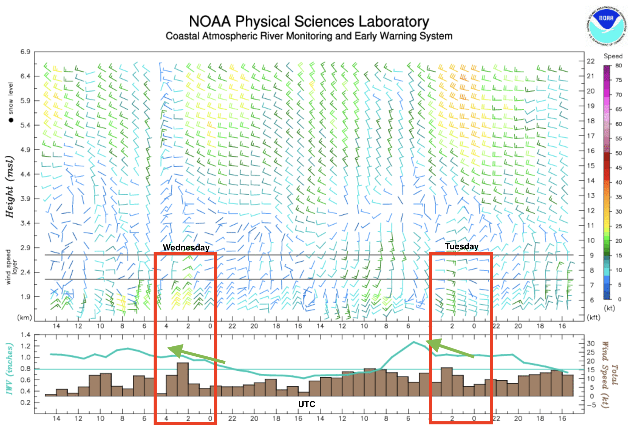
There have been some significant rainfall events across the state over the last couple of days, which include the Denver Metro area. Below is an image from the wind profiler at Platteville, CO (east of Longmont). A wind profiler detects how the wind’s direction and magnitude changes from the surface to 6km upwards. Below in the red boxes are the near-surface evening winds on Tuesday (right) and Wednesday (left). While model guidance was somewhat bullish on whether or not convection would fire over the Front Range, the profiler shows very strong upslope flow from the surface to 3km, which helped to initiate storms. The profiler also shows Integrated Water Vapor (IWV) on the bottom, which shows an increasing trend (green arrow) coinciding with the intensification of the upslope flow. With PW values over an inch and slow steering flows aloft the last couple of days, it is no wonder that the storms have dumped extremely heavy rainfall in their cores. The one saving grace is that the thunderstorms have been more isolated over the Denver Metro area, which has helped to reduce the overall flooding impacts.
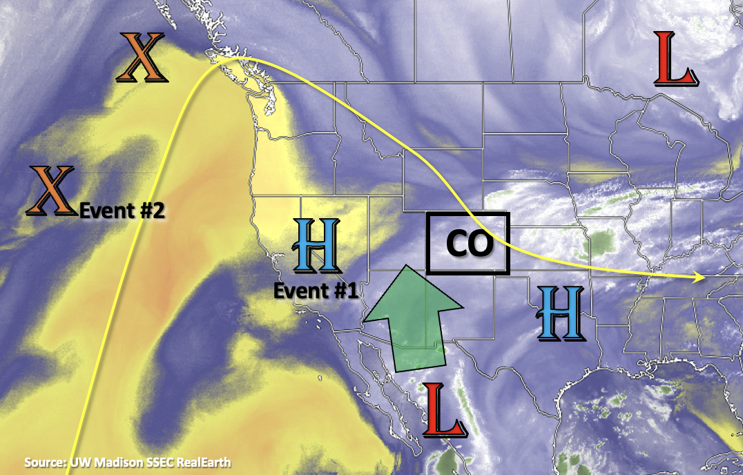
The heavy rainfall threat will continue for this next FTO period as monsoon moisture continues to be syphoned northwards as shown by the green arrow in the water vapor imagery below. It is important to note that several areas have seen days of rainfall at this point (head over to the SPM and check out the 72-hour option), which could increase the localized flood threat if convective storms develop during the afternoons and evenings. This is especially true over portions of the southern high terrains, and these antecedence conditions will be tracked closely in the daily FTB.
During Event #1, the High will begin to rebuild to our west. This should keep moisture elevated across southern and western Colorado through this weekend. A small downtick in moisture, and thus storm activity, is anticipated on Monday, but residual moisture over the western high terrains will likely help produce some isolated afternoon and evening rainfall. Event #2 begins as a shortwave moves inland over the Pacific Northwest and displaces the ridge axis eastward, which should create another monsoon surge. Flow aloft is forecast to turn westerly during this period with a chance of a cool front dropping through the plains, which will should help return rainfall to the area. Soon after Event #2, the ridge begins to build back over the western US (Event #3), pulling moisture northward. At this time, it looks like the highest PW values should be our west, so there is No Apparent flood threat issued. As for high temperatures this week, by Monday, above average temperatures return to most areas, and they should persist over the eastern half of Colorado through the end of the week.
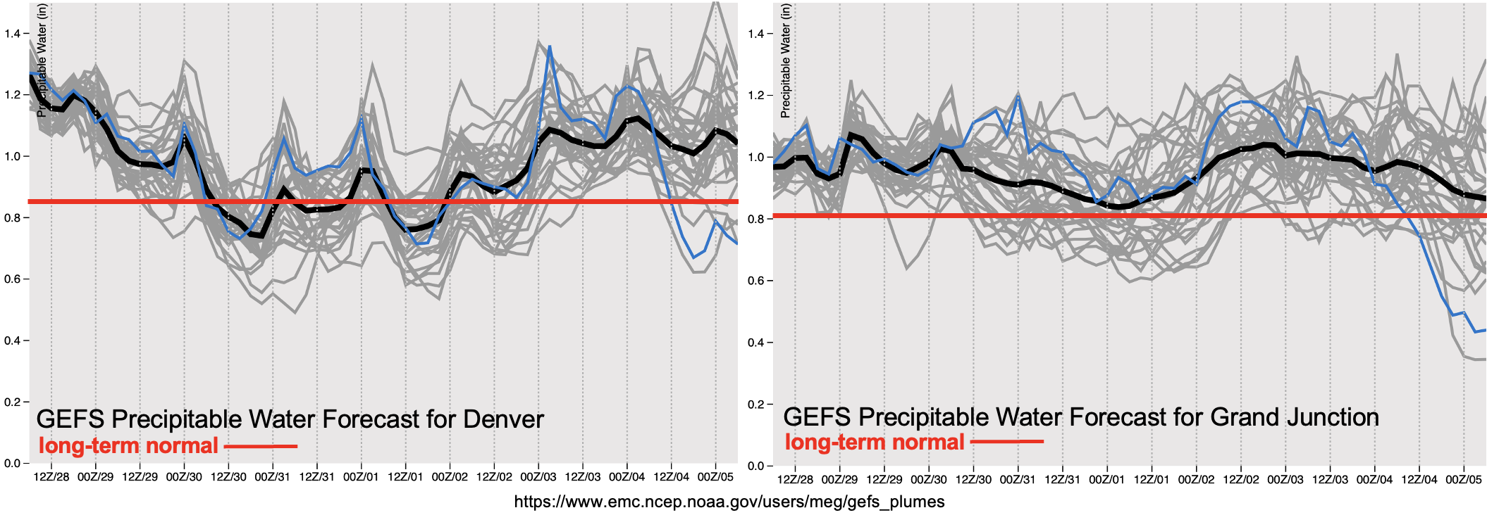
PW plumes below show extremely elevated moisture over the state with the long-term normal (red line) already at or around 0.8 inches. A High flood threat has been issued for tomorrow with an Elevated threat issued through this weekend. The downtick in moisture mentioned above can be seen both over central western and eastern Colorado, but it is likely higher PW values will hang around across the southern border with little change to the synoptic setup or mixing out of the boundary layer moisture. PW begins to climb again over eastern Colorado on Tuesday with the eastward displacement of the ridge, and an Elevated flood threat has been issued for Event #2.
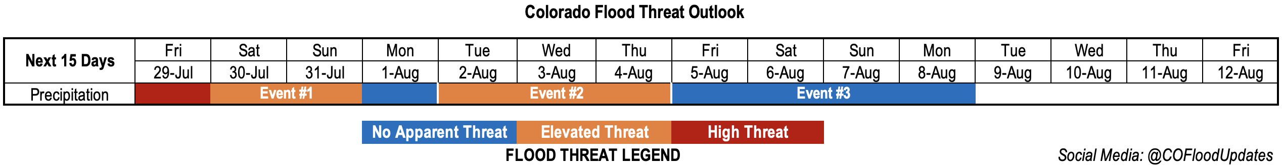
Event #1: Friday – Monday (7/29 – 8/1)
Saturated soils mixed with convection is likely across the southern mountains & will cause a one-day High flood threat to be issued.
As mentioned above, soils are likely very saturated over the southern portion of the state after multiple days of rainfall. Thus, it could take lower rain rates to produce mud flows, debris slides and excessive runoff tomorrow. With max 1-hour rain rates up to 1.25 inches possible and widespread areas potentially receiving at least another inch of rain over the San Juan and Southeast Mountains, a High threat has been issued. Additionally, max 1-hour rain rates up to 1.75 inches may be possible over the western portions of the elevated ridges, which could cause more isolated flooding. The threat for flooding somewhat decreases over the weekend, but isolated downpours could still occur over the southern high terrains, so an Elevated flood threat has been issued. Monday looks to be a quieter weather day with only isolated to widely scattered storms forecast over the western high terrains and southern Southeast Mountains.
Event #2: Tuesday – Thursday (8/2 – 8/4)
Elevated flood threat is issued as the next monsoon surge occurs over western Colorado and spills eastward under westerly flow aloft.
Initially, the flood threat is likely to be over the western high terrains with some stronger thunderstorm activity possible over the Northwest Slope and Northern Mountains. By Wednesday, most of the mountain areas should expect scattered to numerous storms redevelop. Thursday is looking like the most active day with numerous to widespread storms over the state. Increasing westerly steering flows and perhaps a weak boundary may return storm chances to the Northeast Plains and Palmer Ridge. Be sure to tune back into the FTO on Monday as it may be possible for a partial upgrade for this event.
Event #3: Friday – Monday (8/5 – 8/8)
No Apparent flood threat with the ridge building northward over western Colorado.
Still too early to how exactly this event will unfold, but with the ridge axis rebuilding itself over the western US, it is likely that monsoon moisture will move northward with it. Currently, it looks like the largest PW anomalies will stay west of the state, but that forecast could easily change as the event nears. At this time, there is No Apparent flood threat, but worth mentioning there’s a high likelihood for this long monsoon season to continue.