FTO 07-30-2018: On and Off Rainfall Threat with Movement of the Upper-Level Ridge

Issue Date: Monday, July 30th, 2018
Issue Time: 1:20PM MDT
Valid Dates: 7/31– 8/14

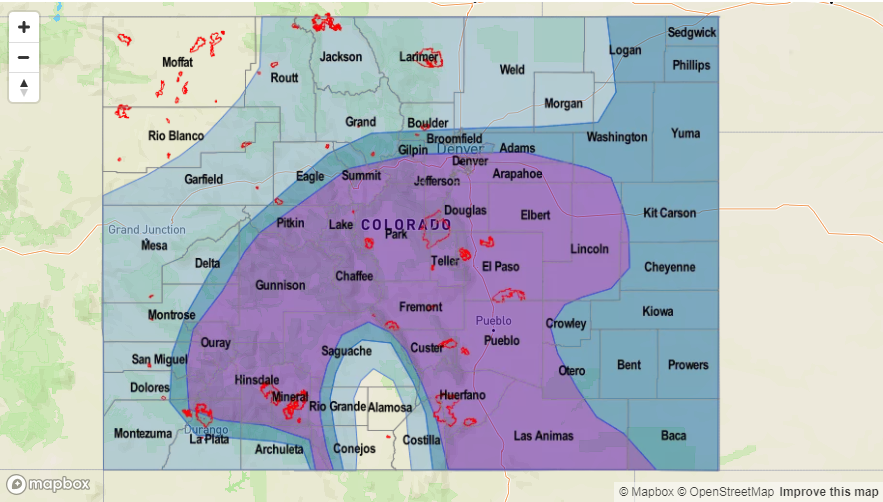
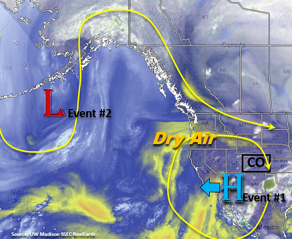
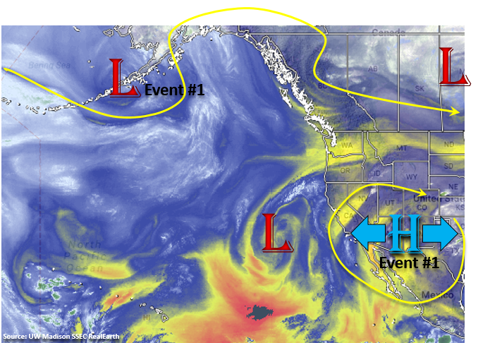
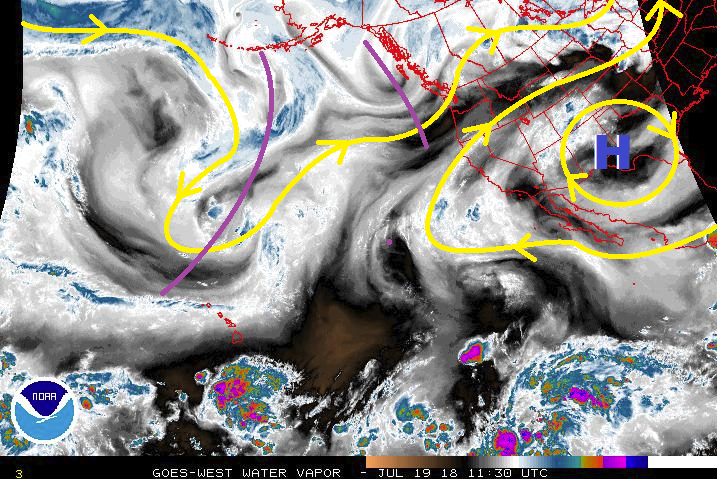
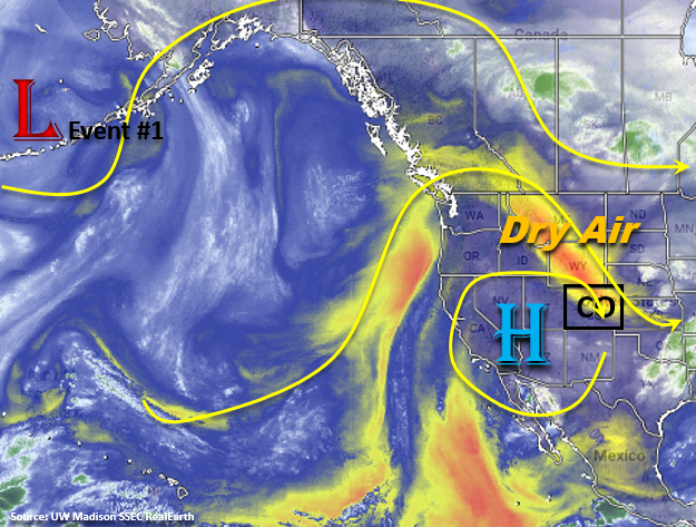
We start this FTO period with a break from the heavy rainfall and severe weather. The flow aloft remains northerly the next couple of days, which will pull in dry air from WY and MT as seen in the water vapor imagery below. This should limit the rainfall chances to the higher terrains and the overall coverage of storms will also be reduced. This is a much needed rainfall break for the eastern plains of Colorado who have just gotten hammered by heavy rain and severe weather since Friday. So for the next couple of days, expect the upper-level high to spin over the Great Basin and dry out the lower-levels. This will allow the high temperatures to bounce back a bit when compared to last week with some of the lower elevations in western Colorado reaching the 90Fs by Tuesday.

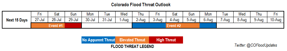
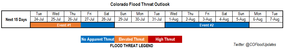
Starting Wednesday, mid-level disturbances will start to increase as a trough moves into the Pacific Northwest. By Thursday, there is a complete breakdown the riding pattern over Colorado and the upper-level flow becomes more zonal. Subtropical moisture will return to the state with the greatest moisture statewide on Friday. The zonal pattern will also push shortwaves through the state, which if timed correctly, will increase lift and coverage of PM thunderstorms. Event #1 will begin on Wednesday (over the Southeast Mountains) and pick up intensity to start next weekend with an Elevated flood threat.

By Sunday, the ridge begins to build back to the west and there should be a temporary decrease in available subtropical moisture and downtick in thunderstorm activity. Convection will still be likely over the higher terrains in the afternoon, but coverage will be greatly reduced. By Monday, the upper-level ridge begins to shift west with another upper trough moving over the Pacific Northwest. If this occurs, this would allow for an influx of subtropical moisture first over western Colorado and then eastern Colorado by Tuesday (Event #2). Confidence is a bit lower in this solution as it is still over a week away.

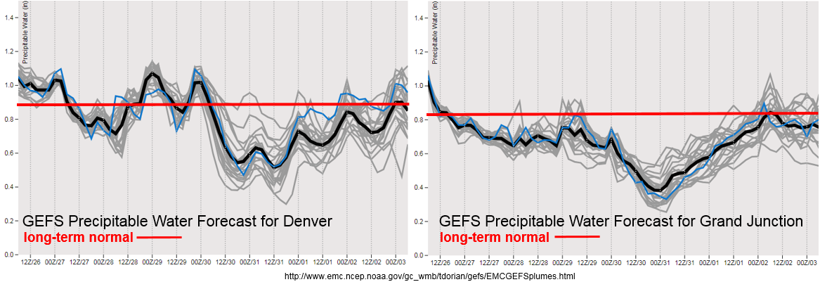
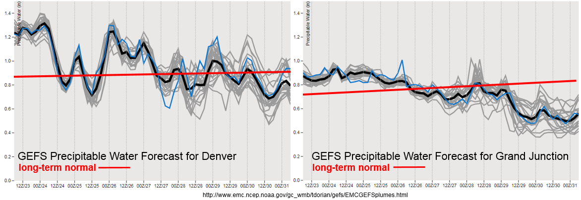
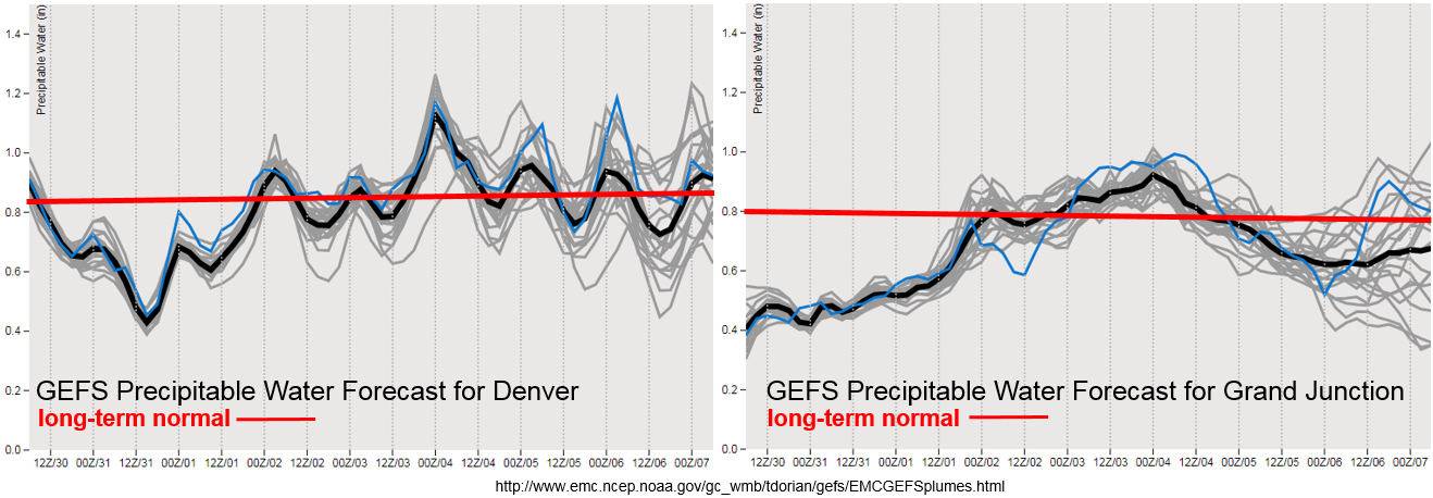
A weak front is forecast to pass through the state on Wednesday, which will increase low-level moisture over the eastern portion of the state. PW is expected to rise the most over the southeast corner of the state on Wednesday, which could return the flood threat to the Southeast Mountain and in particularly, the recent burn scars. Thursday into Friday, PW continues to increase and by Friday, PW will reach its maximum both east and west of the divide. Over western Colorado, the moisture seems to make a run much further north, so the rainfall is expected over the Northern and Central Mountains with the Central Mountains being included in the flood threat on Friday. After Friday, the GEFS ensemble shows some spread in the PW plumes, as there is less confidence as to where the ridge will set up this far out. Likely, moisture will remain high over eastern Colorado and decrease to the west as the ridge begins to build over the southwest again.

Below we describe the two identified precipitation event of this FTO in more detail.

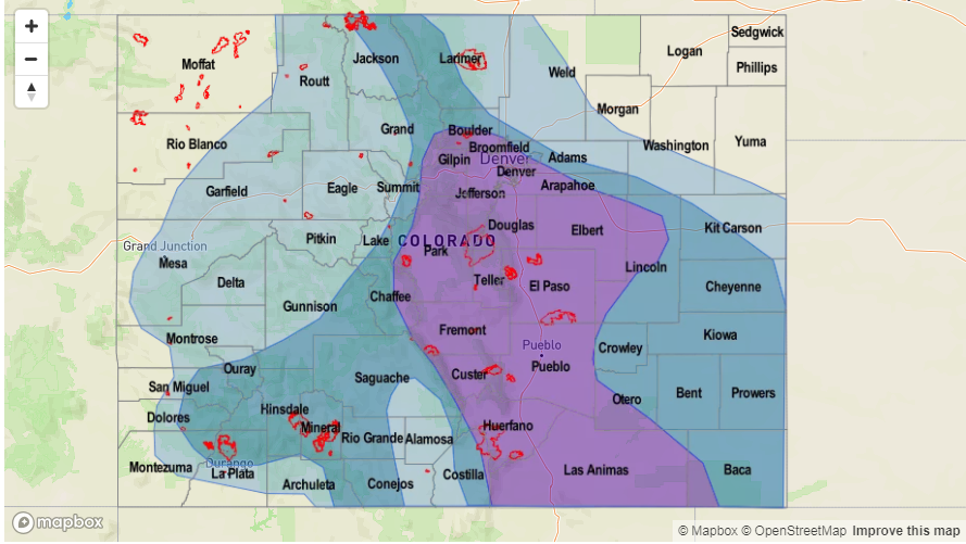
Event #1: Wednesday (8/1) – Saturday (8/4)

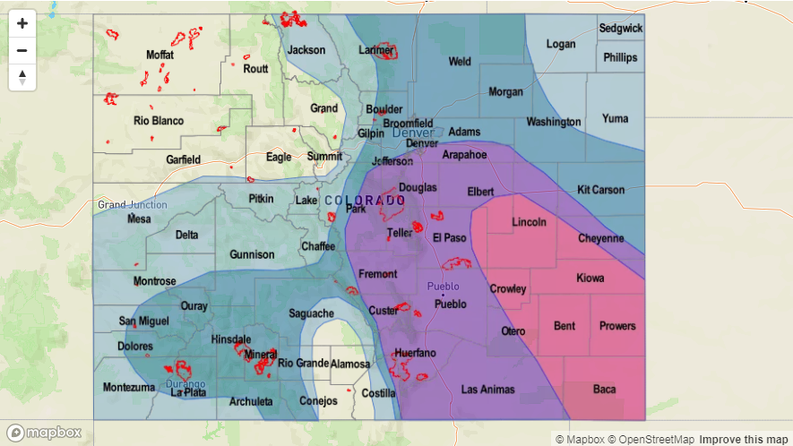
Elevated Threat / No Apparent Threat as the ridge breaks down and zonal flow returns upper-dynamics and subtropical moisture.

After rotating over the desert southwest and drying out the lower-levels, the upper-level high will begin to break down as a trough moves north of Colorado. This should allow subtropical moisture to return to the state, as well as allow multiple mid-level shortwaves to pass through the state and increase thunderstorm coverage. Friday, PW and the flood threat looks to the highest with chances for showers and thunderstorms both east and west of the Continental Divide. Storm motion also looks to decrease at this time, which would allow more rain to fall over one area. This also means an increased risk for mud flows and debris slides over the recent burn scars. Decent CAPE and shear will be in place over the far eastern plains on Friday and Saturday, so storms that form or move into this environment may become severe. The main threats would be local, heavy rainfall, large hail and strong winds. The daily details for this period will be monitored closely in the FTB as the far eastern plains could remain capped.

Legend

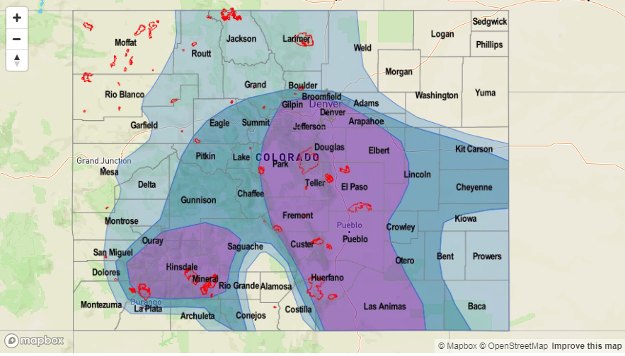
Event #2: Monday (8/6) – Thursday (8/9)

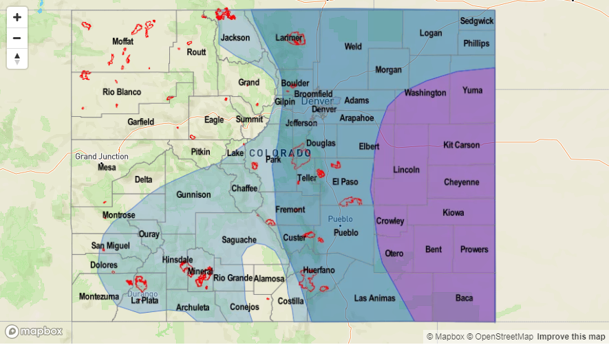
No Apparent Threat as upper-level ridge moves east and allows for subtropical moisture to return to the state.

Less confidence in the forecast due to it being over a week away, but the models are currently digging another trough through the Pacific Northwest. This would push the upper-level ridge east of Colorado, which is a classic pattern that returns subtropical moisture first to the western portion of the state and then to the eastern portion of the state. Thus, the flood threat would return for the showers and thunderstorms that form under the diurnal flow. With the ridge so far north, steering winds are also expected to decrease, so heavy rainfall would be expected. Please return back to the FTO on Thursday as it is likely many details of this forecast will change.


Legend

FTO 07-26-2018: Heavy Rainfall Threat for this Weekend, Then a Statewide Break from Monsoon Moisture

Issue Date: Thursday, July 26th, 2018
Issue Time: 12:20PM MDT
Valid Dates: 7/27– 8/10

High/Elevated flood threat headed into this weekend with the bulk of the activity and chances for flooding occurring over eastern Colorado (Event #1). The center of the upper-level high pressure will move slightly to the west, and spin in place over the southwest corner of the US. The northerly component to the upper-level flow over eastern Colorado will allow shortwaves to move through the state, which if timed correctly, would increase the chances for more widespread shower activity over the mountains and adjacent plains in the afternoon and evening hours. These disturbances and support from the low-level jet (LLJ) could also help to keep thunderstorms rolling into the night over the far eastern plains, where high moisture could cause local flooding. With soils being saturated from the rain over the next two days and overnight rainfall over the Southeast Plains on Saturday, a High flood threat has been issued for the expected widespread, heavy rainfall on Sunday. The Southeast Mountains and adjacent plains will be the most susceptible to flash flooding on Sunday. To the west, sub-tropical moisture gets cut off; however, there will still be a chance for more isolated showers in the afternoon over the higher terrains during the afternoon and evening. The main threats will be gusty winds and dangerous cloud-to-ground lightning. The 416 burn scar will continued to be monitored in the daily FTB as the majority of the rainfall activity will be over the San Juan Mountains.

After Event #1, the ridge will build further to the west and begin pulling in the dry air marked in the water vapor imagery below. This should decrease Precipitable Water (PW) values east/west of the Continental Divide starting Monday and start to increase the high temperatures to at or just above average. After the break in monsoon moisture, a trough begins to move over the west coast, which will bring more zonal flow over the state with the breakdown of the ridge. It’s a bit early to tell how much moisture will be pulled in over the eastern plains with low-level southeasterly flow, but shortwaves embedded in the westerly flow could return the flood threat to eastern Colorado. Currently, the GFS is pulling in very high PW values over next weekend. This is due to the ridge shifting east of Colorado, which would allow subtropical moisture to rotate clockwise around the upper-level high into the state. It is a bit far out to put high confidence in this solution, but it is monsoon season, and this event is looking more and more like the traditional atmospheric setup seen during the North American Monsoon.

A cold front is forecast to pass through the state on Sunday, which should drop temperatures on Sunday into the upper 70sF over northeastern Colorado. The cold front will also help moisten the boundary layer, which means there will be a good chance for flooding on Sunday as rain rates will become more efficient. There is also a rebound in PW over eastern Colorado from Friday into Saturday, which can be seen in the PW plumes from the GEFS (above) over Denver. Starting Monday, the upper-level high traverses more to the west and the drying trend begins. This is noted both in the Denver and Grand Junction GEFS PW forecasts. As the ridge breaks down mid-next week, the PW values start to rise again over Colorado and the bridge starts to build to the east of the state. Still a lot of spread in the model PW values, but they look to rebound to more normal values for this time of year. The FTOs next week will offer a better look into flooding potential at the beginning of August. As a side note, this is about the time of year the PW maxes out. Usually the red line or long-term normal has a slightly positive tilt, but for this FTO it is completely flat. Below we describe the two identified precipitation event of this FTO in more detail.

Event #1: Friday (7/27) – Sunday (7/29)

High/Elevated Threat for flash flooding and severe thunderstorms over eastern Colorado.

The upper-level high is still expected to migrate slightly west of its current position. With northwesterly flow aloft, this will allow for a cold front to pass through the state this weekend. Low-level moisture will enrich the boundary layer and upper dynamics will increase the likelihood for severe thunderstorms. The boundary and LLJ may also act as a lifting mechanism for overnight thunderstorms, which could cause flooding due to the more stationary rainfall. The greatest chance for widespread showers and thunderstorms over eastern Colorado will be Saturday and Sunday. Due to the rainfall over the next couple of days and highly efficient rainfall rates expected on Sunday, a High threat has been issued. Burn scars over the Southeast Mountains will be watched closely on Sunday for the potential of mud flows and debris slides. After Sunday, PW values decrease giving us a break from heavy rainfall through Wednesday. To the east, the best chance for rainfall is over the San Juan Mountains. Max 1-hour values should be less than 1 inch/hour, but rain rates are still expected to be high enough to trigger possible debris flows over the 416 fire scar. The daily potential for burn scar flash flooding will be evaluated in the daily FTB.


Legend

Event #2: Thursday (8/2) – Monday (8/6)

No Apparent Threat as upper-level ridge becomes flattened by an approach west coast trough.

The blocking/strong riding pattern starts to break down on Wednesday, which will create more westerly flow aloft. The ridge is forecast to move to the east, which would allow subtropical moisture to return to the state. The flattening of the ridge may also allow more shortwaves to pass through the state, which if timed with the upslope flow could increase thunderstorm coverage. The projected upper-level high over TX and eastward would mean the heavy rainfall threat would return to Colorado. This would be more of the typical pattern associated with the North American Monsoon (NAM). Be sure to check back to the FTO for a higher confidence forecast next week as the details continue to evolve.


Legend

FTO 07-23-2018: On and Off Low-Level Moisture with the Passage of Cold Fronts

Issue Date: Monday, July 23rd, 2018
Issue Time: 1:25PM MDT
Valid Dates: 7/24– 8/7

Looking forward to the next 15 days for this FTO period, there is an Elevated flood threat, followed by a lull in rainfall before Event #2 kicks off August. It has been a bit of strange monsoon season as the upper-level high has sat more to the west rather than moving east to situate itself over the High Plains. While slight shifts in this ridge to the east and west have allowed subtropical moisture to be pulled into Colorado, we have yet to have an event where both Gulf of Mexico and Gulf of California moisture have been present at the same time. This pattern continues for this next FTO period with only slight shifts in the upper-level high expected, as an omega block will set up to the north. The result is minor movements in the upper-level high will drive Colorado’s high temperatures and precipitation chances. By the end of this FTO, an upper trough will move over the Pacific Northwest and it looks to push the upper-high to the east and into a more favorable position for subtropical moisture return. It is still is a bit far out to place high confidence into this solution, but it will be monitored over the next week.

Precipitable Water (PW) remains high over eastern Colorado today before it begins to drop off east of the Continental Divide. By Wednesday afternoon, a cold front is expected to slide through the state, which should help moisten the lower levels for more abundant afternoon showers and thunderstorms. At this time, low-level moisture looks sufficient to return the threat for heavy rainfall and flooding; thus, the Elevated flood threat. Another cold front is likely to move through the state on Saturday afternoon, which returns some moisture to the west, but the heavy rainfall threat should just be over the eastern plains. East of the Divide, there is not much change in the PW values over the next couple of days. Under this regime, the atmosphere has not been producing very efficient rain rates, so other than near burn scars, flash flooding is not likely. Though, Tuesday there is a chance for max 1-hour rain rates to reach 1 inch/hour, which may cause mud flows, debris slides and local stream flooding. With W/WNW flow aloft, the rainfall that does fall should be confined to the higher terrains. By later this week into this weekend, the lack of low-level moisture should give Colorado a break from the heavy rainfall until the omega block is able to breakdown next week. Temperatures will be up and down with the passages of the cold fronts, but overall, a nice break from extreme high temperatures is anticipated.

Below we describe the two identified precipitation event of this FTO in more detail.

Event #1: Tuesday (7/24) – Saturday (7/28)

Elevated/No Apparent Threat for afternoon, terrain induced thunderstorms as cold fronts moisten the lower levels of the atmosphere.

The upper-level high will migrate slightly west and east of its current position. With northwesterly flow aloft over Eastern Colorado, this will allow for cold front passages over the state. After the cold fronts pass through, the low-level moisture will become enriched and increase the changes for heavy rainfall in the afternoon over the mountains and portions of the adjacent plains. When the ridge shifts west, the chances for heavy rainfall decrease in the afternoon and evenings. The first front is expected to pass through the state on Wednesday, while the second front will pass through on Saturday. These should be the days with the greatest heavy rainfall threat at this time. PW values remain elevated over eastern CO through Thursday due to Gulf of Mexico moisture being streamed into the state with low-level SE/E flow. Each afternoon there will be a threat of heavy rainfall due this factor. To the west, the best chance for heavy rainfall is Tuesday over the San Juan Mountains. Max 1-hour values should be around 1 inch/hour, which would pose a threat to burn scars. Please tune back into the daily FTB for more details as slight changes to this weekend’s forecast will be likely.

Legend

Event #2: Wednesday (8/1) – Sunday (8/5)

No Apparent Threat as omega block breaks down and allows the upper-level ridge to shift eastward.

The omega block starts to break down over this period, which will push the upper-level high over the desert SW towards the east. This will allow subtropical moisture to return to the state as well as more northerly flow. The more northerly flow will allow the passage of cold fronts, which could help moisten the low-level flow. The details of this event will change over the next week, but the projected upper-level high over TX and eastward would mean the heavy rainfall threat would return to Colorado. Be sure to check back to the FTO for a higher confidence forecast Thursday and next Monday. Getting a little bit excited as glimpses of a more typical North American Monsoon pattern are being hinted at by long-term models. Southern Colorado really needs the moisture as a large portion of southern Colorado is under an Exceptional Drought (D4 intensity).

Legend

FTO 07-19-2018: Two Events in First 9 Days, Possibly a Third Late in the Period

Issue Date: 7/19/2018
Issue Time: 9:55 AM

To start off today’s edition of the FTO, let’s take a quick look at the most recent drought monitor, released this morning at 6 AM MDT. Nearly 77% of the state is in moderate drought or worse, with just over 13% of the state under Exceptional Drought conditions. Northeast Colorado continues to avoid drought conditions, reaping the benefits of the spring/early summer storm track.

Looking forward to the next 15 days, the first half of the period looks to be the wettest, with the majority of the activity occurring during the first four days, designated Event #1 (Friday, July 20th – Monday, July 23rd). Event #1 is a combination of monsoonal moisture, disturbances aloft (purple lines in water vapor image), a weak cool front, and easterly upslope flow behind the front. Precipitation chances begin to increase on Friday, mainly over/near the High Country, as monsoonal moisture works in from the southwest thanks to the shift of the upper-level high over the southern Great Plains. Through the weekend, precipitation chances will increase across the plains, as well, as monsoonal moisture spreads over the area on Saturday, with a cool front pushing southward through eastern Colorado on Sunday. Surface convergence along the front, as well as the transport of low-level moisture from the Great Plains, will increase the threat of heavy rain and organized thunderstorm activity. Monday looks to be the wettest day of the event, as monsoonal moisture, a disturbance aloft, and upslope flow behind the front all combine to bring the threat of heavy rain to much of Colorado. Precipitable water values will be near 1 inch in lower mountain valleys, and over 1 inch everywhere east of the mountains. This is plenty of moisture for efficient precipitation production, thus Monday is expected to be the most widespread flood threat day of Event #1.

The upper-level high will shift back westward, becoming centered over the Great Basin by late Tuesday, allowing drier air to work back into Colorado for Tuesday/Wednesday (July 24th/25th). Even so, enough residual moisture will be hanging around for a few scattered showers/garden-variety thunderstorms over the higher terrain during this two-day period. Event #2 begins on Thursday, July 26th, continuing through Saturday, July 28th, in the form of multiple disturbances working across eastern Colorado. This will send another weak cool front or two surging through the eastern plains, with upslope flow behind the front transporting moisture back into the foothills. There are some discrepancies on the eventual evolution of this event, as well as the amount of moisture that will return, so no flood threat designation is warranted at this time.

After Event #2, Colorado will likely dry out for the remainder of the period, with potentially a third event coming to fruition to begin August. This is a plausible scenario, given the start of monsoon season is nearly upon us, but significant uncertainty precludes the issuance of an event designation. Instead, consider this mention as something for which to be on the lookout, and an update will be provided in Monday’s edition of the FTO.

Event #1: Friday (07-20-2018) through Monday (07-23-2016)

Elevated Flood Threat as Monsoonal Moisture Combines with Other Factors

Event #1 is a combination of monsoonal moisture, disturbances aloft, a weak surface cool front, and easterly upslope flow. The majority of the state will get in on the rainfall, with the wettest day of the event being Monday. Precipitable water values will increase through the event, topping out at over an inch across eastern Colorado, with values near 1 inch over the High Country. This will lead to efficient rainfall production, especially Sunday/Monday. It will be important to monitor burn scars, especially sensitive ones like the 416, Spring, Burro, and other recent/ongoing burns, as well as urban areas and steep terrain.

Legend

Event #2: Thursday (07-26-2018) through Saturday (07-28-2018)

No Apparent Threat due to Questions Regarding Moisture Return

Multiple disturbances aloft and another cool front surging southward through eastern Colorado are the main culprits behind Event #2. This event will be mainly for areas east of the Continental Divide, with more garden-variety showers/thunderstorms west of the Divide. Moisture return is a question mark at this time, so no flood threat designation will be assigned. The Urban Corridor, Front Range, Southeast Mountains, Palmer Ridge, and western portions of the Northeast Plains and Southeast Plains will be the focus areas for thunderstorms capable of heavy rainfall.

Legend