Issue Date: Monday, July 30th, 2018
Issue Time: 1:20PM MDT
Valid Dates: 7/31– 8/14
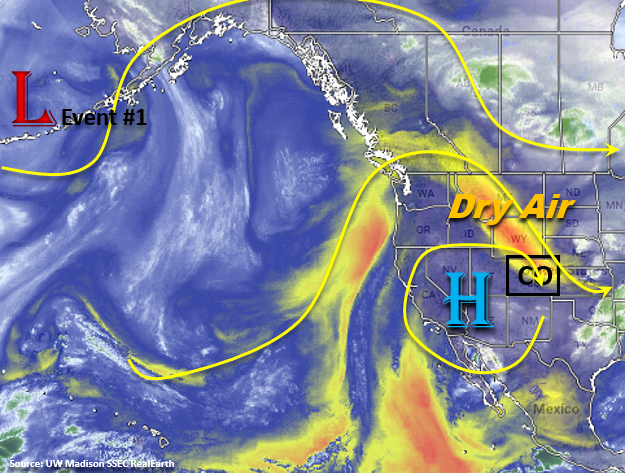
We start this FTO period with a break from the heavy rainfall and severe weather. The flow aloft remains northerly the next couple of days, which will pull in dry air from WY and MT as seen in the water vapor imagery below. This should limit the rainfall chances to the higher terrains and the overall coverage of storms will also be reduced. This is a much needed rainfall break for the eastern plains of Colorado who have just gotten hammered by heavy rain and severe weather since Friday. So for the next couple of days, expect the upper-level high to spin over the Great Basin and dry out the lower-levels. This will allow the high temperatures to bounce back a bit when compared to last week with some of the lower elevations in western Colorado reaching the 90Fs by Tuesday.
Starting Wednesday, mid-level disturbances will start to increase as a trough moves into the Pacific Northwest. By Thursday, there is a complete breakdown the riding pattern over Colorado and the upper-level flow becomes more zonal. Subtropical moisture will return to the state with the greatest moisture statewide on Friday. The zonal pattern will also push shortwaves through the state, which if timed correctly, will increase lift and coverage of PM thunderstorms. Event #1 will begin on Wednesday (over the Southeast Mountains) and pick up intensity to start next weekend with an Elevated flood threat.
By Sunday, the ridge begins to build back to the west and there should be a temporary decrease in available subtropical moisture and downtick in thunderstorm activity. Convection will still be likely over the higher terrains in the afternoon, but coverage will be greatly reduced. By Monday, the upper-level ridge begins to shift west with another upper trough moving over the Pacific Northwest. If this occurs, this would allow for an influx of subtropical moisture first over western Colorado and then eastern Colorado by Tuesday (Event #2). Confidence is a bit lower in this solution as it is still over a week away.
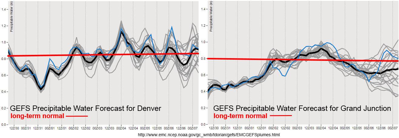
A weak front is forecast to pass through the state on Wednesday, which will increase low-level moisture over the eastern portion of the state. PW is expected to rise the most over the southeast corner of the state on Wednesday, which could return the flood threat to the Southeast Mountain and in particularly, the recent burn scars. Thursday into Friday, PW continues to increase and by Friday, PW will reach its maximum both east and west of the divide. Over western Colorado, the moisture seems to make a run much further north, so the rainfall is expected over the Northern and Central Mountains with the Central Mountains being included in the flood threat on Friday. After Friday, the GEFS ensemble shows some spread in the PW plumes, as there is less confidence as to where the ridge will set up this far out. Likely, moisture will remain high over eastern Colorado and decrease to the west as the ridge begins to build over the southwest again.
Below we describe the two identified precipitation event of this FTO in more detail.
Event #1: Wednesday (8/1) – Saturday (8/4)
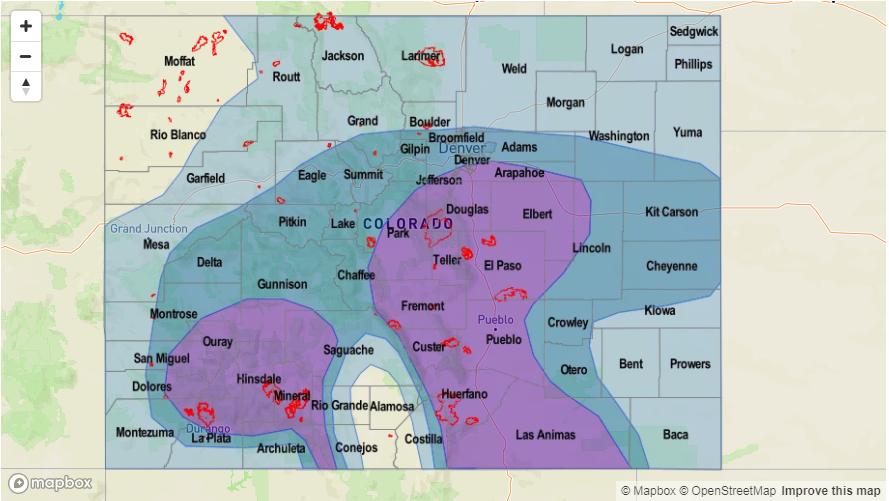
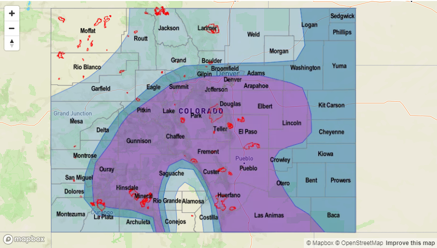
Elevated Threat / No Apparent Threat as the ridge breaks down and zonal flow returns upper-dynamics and subtropical moisture.
After rotating over the desert southwest and drying out the lower-levels, the upper-level high will begin to break down as a trough moves north of Colorado. This should allow subtropical moisture to return to the state, as well as allow multiple mid-level shortwaves to pass through the state and increase thunderstorm coverage. Friday, PW and the flood threat looks to the highest with chances for showers and thunderstorms both east and west of the Continental Divide. Storm motion also looks to decrease at this time, which would allow more rain to fall over one area. This also means an increased risk for mud flows and debris slides over the recent burn scars. Decent CAPE and shear will be in place over the far eastern plains on Friday and Saturday, so storms that form or move into this environment may become severe. The main threats would be local, heavy rainfall, large hail and strong winds. The daily details for this period will be monitored closely in the FTB as the far eastern plains could remain capped.
Event #2: Monday (8/6) – Thursday (8/9)
No Apparent Threat as upper-level ridge moves east and allows for subtropical moisture to return to the state.
Less confidence in the forecast due to it being over a week away, but the models are currently digging another trough through the Pacific Northwest. This would push the upper-level ridge east of Colorado, which is a classic pattern that returns subtropical moisture first to the western portion of the state and then to the eastern portion of the state. Thus, the flood threat would return for the showers and thunderstorms that form under the diurnal flow. With the ridge so far north, steering winds are also expected to decrease, so heavy rainfall would be expected. Please return back to the FTO on Thursday as it is likely many details of this forecast will change.


