Issue Date: Monday, July 23rd, 2018
Issue Time: 1:25PM MDT
Valid Dates: 7/24– 8/7
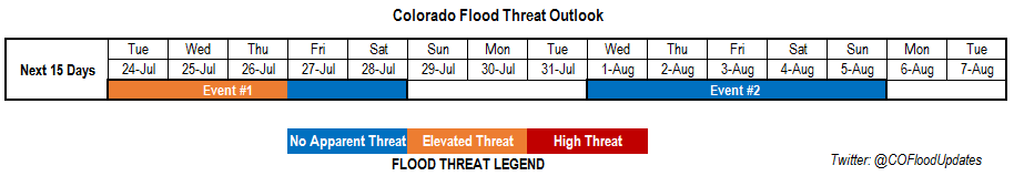
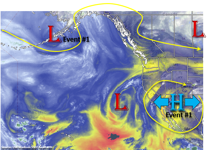
Looking forward to the next 15 days for this FTO period, there is an Elevated flood threat, followed by a lull in rainfall before Event #2 kicks off August. It has been a bit of strange monsoon season as the upper-level high has sat more to the west rather than moving east to situate itself over the High Plains. While slight shifts in this ridge to the east and west have allowed subtropical moisture to be pulled into Colorado, we have yet to have an event where both Gulf of Mexico and Gulf of California moisture have been present at the same time. This pattern continues for this next FTO period with only slight shifts in the upper-level high expected, as an omega block will set up to the north. The result is minor movements in the upper-level high will drive Colorado’s high temperatures and precipitation chances. By the end of this FTO, an upper trough will move over the Pacific Northwest and it looks to push the upper-high to the east and into a more favorable position for subtropical moisture return. It is still is a bit far out to place high confidence into this solution, but it will be monitored over the next week.
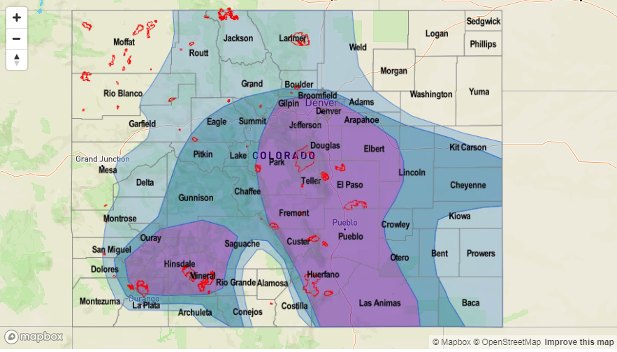
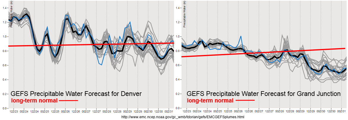
Precipitable Water (PW) remains high over eastern Colorado today before it begins to drop off east of the Continental Divide. By Wednesday afternoon, a cold front is expected to slide through the state, which should help moisten the lower levels for more abundant afternoon showers and thunderstorms. At this time, low-level moisture looks sufficient to return the threat for heavy rainfall and flooding; thus, the Elevated flood threat. Another cold front is likely to move through the state on Saturday afternoon, which returns some moisture to the west, but the heavy rainfall threat should just be over the eastern plains. East of the Divide, there is not much change in the PW values over the next couple of days. Under this regime, the atmosphere has not been producing very efficient rain rates, so other than near burn scars, flash flooding is not likely. Though, Tuesday there is a chance for max 1-hour rain rates to reach 1 inch/hour, which may cause mud flows, debris slides and local stream flooding. With W/WNW flow aloft, the rainfall that does fall should be confined to the higher terrains. By later this week into this weekend, the lack of low-level moisture should give Colorado a break from the heavy rainfall until the omega block is able to breakdown next week. Temperatures will be up and down with the passages of the cold fronts, but overall, a nice break from extreme high temperatures is anticipated.
Below we describe the two identified precipitation event of this FTO in more detail.
Event #1: Tuesday (7/24) – Saturday (7/28)
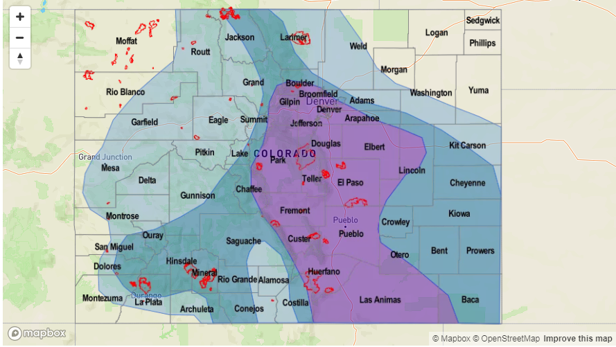
Elevated/No Apparent Threat for afternoon, terrain induced thunderstorms as cold fronts moisten the lower levels of the atmosphere.
The upper-level high will migrate slightly west and east of its current position. With northwesterly flow aloft over Eastern Colorado, this will allow for cold front passages over the state. After the cold fronts pass through, the low-level moisture will become enriched and increase the changes for heavy rainfall in the afternoon over the mountains and portions of the adjacent plains. When the ridge shifts west, the chances for heavy rainfall decrease in the afternoon and evenings. The first front is expected to pass through the state on Wednesday, while the second front will pass through on Saturday. These should be the days with the greatest heavy rainfall threat at this time. PW values remain elevated over eastern CO through Thursday due to Gulf of Mexico moisture being streamed into the state with low-level SE/E flow. Each afternoon there will be a threat of heavy rainfall due this factor. To the west, the best chance for heavy rainfall is Tuesday over the San Juan Mountains. Max 1-hour values should be around 1 inch/hour, which would pose a threat to burn scars. Please tune back into the daily FTB for more details as slight changes to this weekend’s forecast will be likely.

Event #2: Wednesday (8/1) – Sunday (8/5)
No Apparent Threat as omega block breaks down and allows the upper-level ridge to shift eastward.
The omega block starts to break down over this period, which will push the upper-level high over the desert SW towards the east. This will allow subtropical moisture to return to the state as well as more northerly flow. The more northerly flow will allow the passage of cold fronts, which could help moisten the low-level flow. The details of this event will change over the next week, but the projected upper-level high over TX and eastward would mean the heavy rainfall threat would return to Colorado. Be sure to check back to the FTO for a higher confidence forecast Thursday and next Monday. Getting a little bit excited as glimpses of a more typical North American Monsoon pattern are being hinted at by long-term models. Southern Colorado really needs the moisture as a large portion of southern Colorado is under an Exceptional Drought (D4 intensity).