Issue Date: Thursday, July 26th, 2018
Issue Time: 12:20PM MDT
Valid Dates: 7/27– 8/10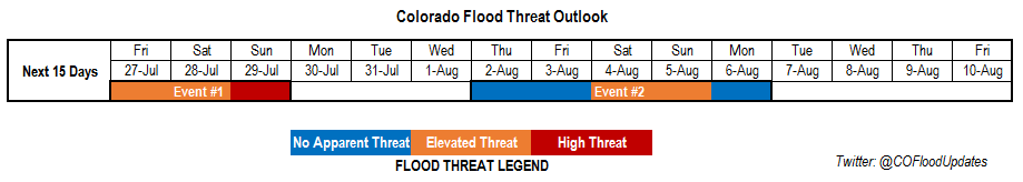
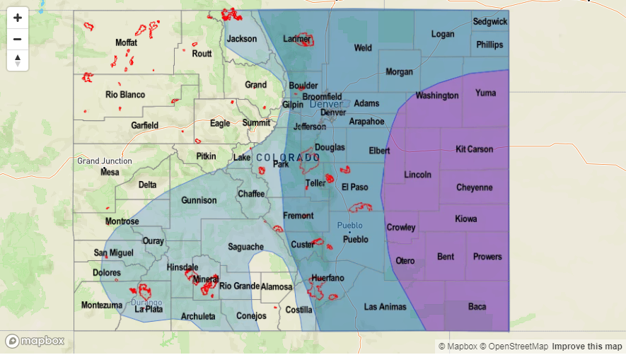
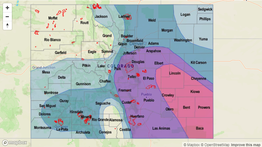
High/Elevated flood threat headed into this weekend with the bulk of the activity and chances for flooding occurring over eastern Colorado (Event #1). The center of the upper-level high pressure will move slightly to the west, and spin in place over the southwest corner of the US. The northerly component to the upper-level flow over eastern Colorado will allow shortwaves to move through the state, which if timed correctly, would increase the chances for more widespread shower activity over the mountains and adjacent plains in the afternoon and evening hours. These disturbances and support from the low-level jet (LLJ) could also help to keep thunderstorms rolling into the night over the far eastern plains, where high moisture could cause local flooding. With soils being saturated from the rain over the next two days and overnight rainfall over the Southeast Plains on Saturday, a High flood threat has been issued for the expected widespread, heavy rainfall on Sunday. The Southeast Mountains and adjacent plains will be the most susceptible to flash flooding on Sunday. To the west, sub-tropical moisture gets cut off; however, there will still be a chance for more isolated showers in the afternoon over the higher terrains during the afternoon and evening. The main threats will be gusty winds and dangerous cloud-to-ground lightning. The 416 burn scar will continued to be monitored in the daily FTB as the majority of the rainfall activity will be over the San Juan Mountains.
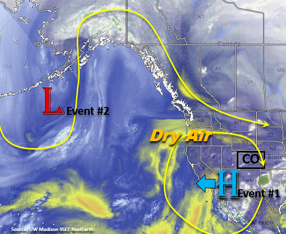
After Event #1, the ridge will build further to the west and begin pulling in the dry air marked in the water vapor imagery below. This should decrease Precipitable Water (PW) values east/west of the Continental Divide starting Monday and start to increase the high temperatures to at or just above average. After the break in monsoon moisture, a trough begins to move over the west coast, which will bring more zonal flow over the state with the breakdown of the ridge. It’s a bit early to tell how much moisture will be pulled in over the eastern plains with low-level southeasterly flow, but shortwaves embedded in the westerly flow could return the flood threat to eastern Colorado. Currently, the GFS is pulling in very high PW values over next weekend. This is due to the ridge shifting east of Colorado, which would allow subtropical moisture to rotate clockwise around the upper-level high into the state. It is a bit far out to put high confidence in this solution, but it is monsoon season, and this event is looking more and more like the traditional atmospheric setup seen during the North American Monsoon.
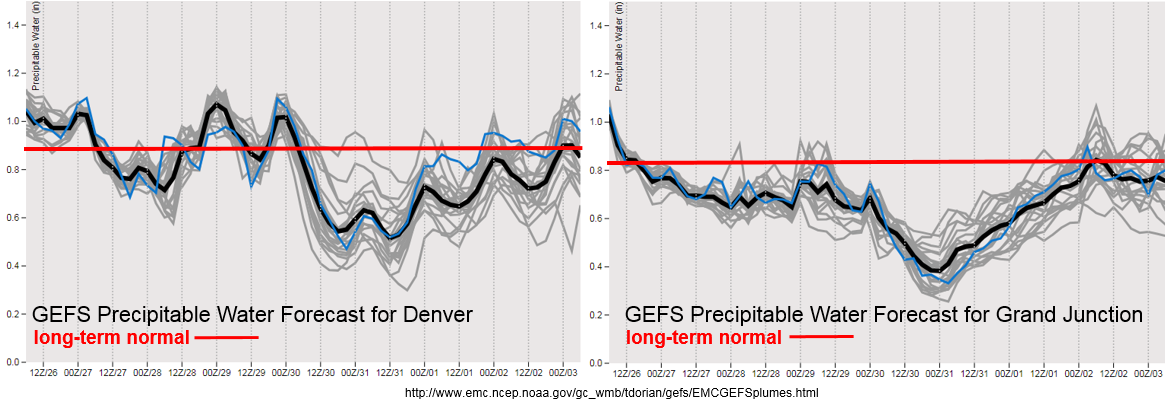
A cold front is forecast to pass through the state on Sunday, which should drop temperatures on Sunday into the upper 70sF over northeastern Colorado. The cold front will also help moisten the boundary layer, which means there will be a good chance for flooding on Sunday as rain rates will become more efficient. There is also a rebound in PW over eastern Colorado from Friday into Saturday, which can be seen in the PW plumes from the GEFS (above) over Denver. Starting Monday, the upper-level high traverses more to the west and the drying trend begins. This is noted both in the Denver and Grand Junction GEFS PW forecasts. As the ridge breaks down mid-next week, the PW values start to rise again over Colorado and the bridge starts to build to the east of the state. Still a lot of spread in the model PW values, but they look to rebound to more normal values for this time of year. The FTOs next week will offer a better look into flooding potential at the beginning of August. As a side note, this is about the time of year the PW maxes out. Usually the red line or long-term normal has a slightly positive tilt, but for this FTO it is completely flat. Below we describe the two identified precipitation event of this FTO in more detail.
Event #1: Friday (7/27) – Sunday (7/29)
High/Elevated Threat for flash flooding and severe thunderstorms over eastern Colorado.
The upper-level high is still expected to migrate slightly west of its current position. With northwesterly flow aloft, this will allow for a cold front to pass through the state this weekend. Low-level moisture will enrich the boundary layer and upper dynamics will increase the likelihood for severe thunderstorms. The boundary and LLJ may also act as a lifting mechanism for overnight thunderstorms, which could cause flooding due to the more stationary rainfall. The greatest chance for widespread showers and thunderstorms over eastern Colorado will be Saturday and Sunday. Due to the rainfall over the next couple of days and highly efficient rainfall rates expected on Sunday, a High threat has been issued. Burn scars over the Southeast Mountains will be watched closely on Sunday for the potential of mud flows and debris slides. After Sunday, PW values decrease giving us a break from heavy rainfall through Wednesday. To the east, the best chance for rainfall is over the San Juan Mountains. Max 1-hour values should be less than 1 inch/hour, but rain rates are still expected to be high enough to trigger possible debris flows over the 416 fire scar. The daily potential for burn scar flash flooding will be evaluated in the daily FTB.

Event #2: Thursday (8/2) – Monday (8/6)
No Apparent Threat as upper-level ridge becomes flattened by an approach west coast trough.
The blocking/strong riding pattern starts to break down on Wednesday, which will create more westerly flow aloft. The ridge is forecast to move to the east, which would allow subtropical moisture to return to the state. The flattening of the ridge may also allow more shortwaves to pass through the state, which if timed with the upslope flow could increase thunderstorm coverage. The projected upper-level high over TX and eastward would mean the heavy rainfall threat would return to Colorado. This would be more of the typical pattern associated with the North American Monsoon (NAM). Be sure to check back to the FTO for a higher confidence forecast next week as the details continue to evolve.