FTO 08-13-2018: Active Week Ahead with Possible Severe Thunderstorms for Eastern Colorado on Wednesday

Issue Date: Monday, August 13th, 2018
Issue Time: 1:25 PM MDT
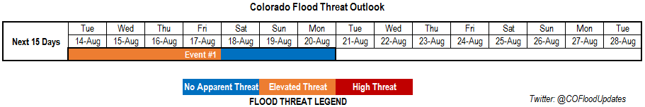
Valid Dates: 8/14 – 8/28

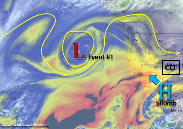
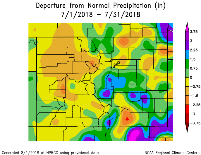
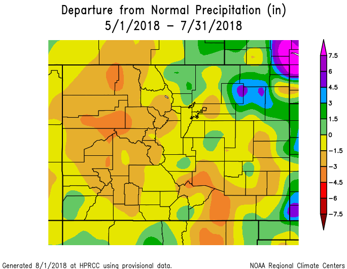
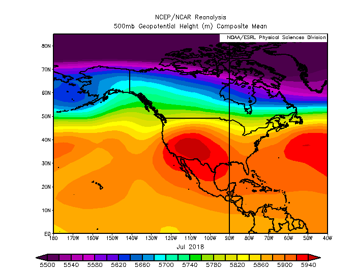
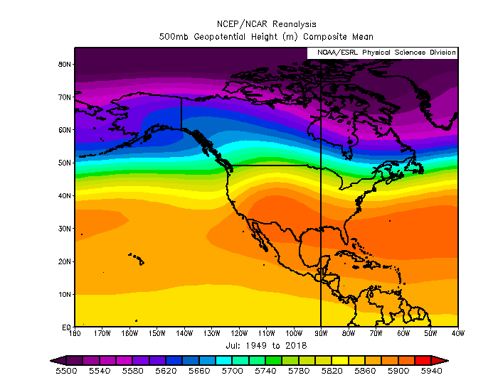
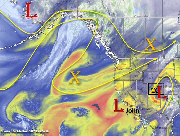
It is mid-August already, which means climatologically we’ve started the descent from the peak of the North American Monsoon (NAM). At the beginning of the season (May), Climate Prediction Center predicted above average precipitation for June, July and August over western Colorado (40-50% probability). Over eastern Colorado, there was equal chance for above/below average precipitation. Unfortunately, the majority of western Colorado continues to be at 10-50% of normal precipitation. To further look into the overall pattern in July (the NAM), we took at a quick look at the NCEP/NCAR reanalysis data. Below is the 500mb geopotential heights for July 2018 (top) and July 1949-2018 or climatology (bottom). It shows that throughout July there was an anomalously strong high pressure center over the southwest US with the axis of the subtropical ridge extending further west than normal. This is similar to what we saw in observations for the Flood Threat Bulletin. For the most part, there were only slight movements with the center of the high to the east and west, which allowed for minimal subtropical moisture return or “monsoon surges” over western Colorado. There is still a chance for a couple more surges before the subtropical ridge shifts back south, but the 2018 monsoon season has been quiet when compared to season’s past.

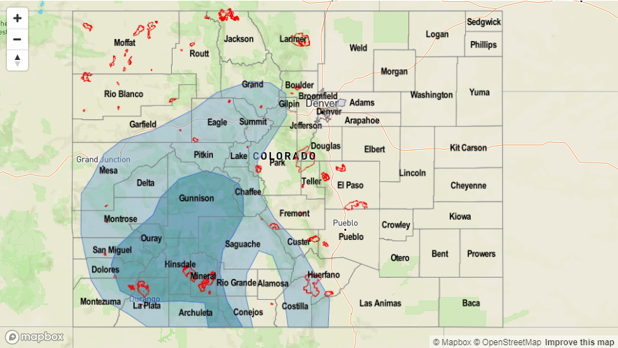
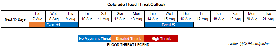
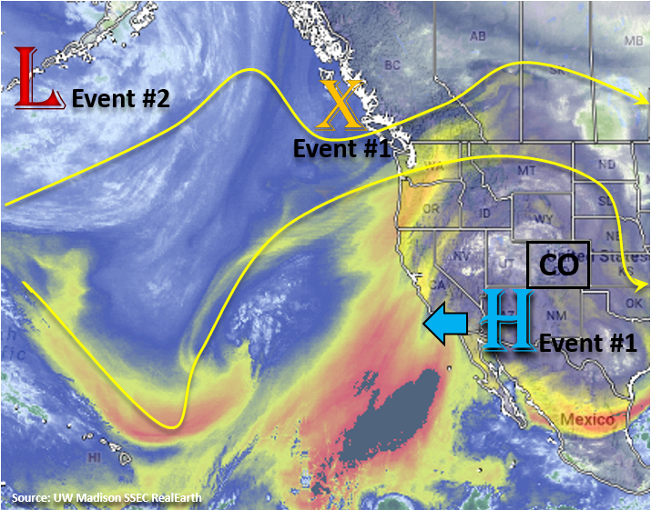
There is only one identified event for this next FTO, which begins tomorrow and brings an Elevated Flood Threat to the state the rest of this week. The upper-level low over southeastern Colorado will begin to move to the east through tomorrow, and in its place, the subtropical ridge will begin to build again over the west. This should allow Gulf of Mexico low-level moisture to start to fill in over eastern Colorado. Thus, there will be an increase of storms over the eastern mountains beginning tomorrow. Flow aloft will become northwesterly again, which will promote an active weather pattern by allowing fronts to pass through the state. On Wednesday, the first boundary passes through the northeast corner of the state and brings a chance for some larger thunderstorms over the eastern plains. High instability and 40 knots of shear associated with a lee trough will promote possibly severe thunderstorms, which would be capable of producing strong winds, large hail and heavy rainfall.

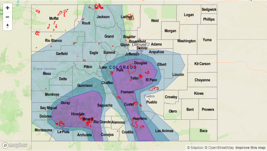
By Thursday, the subtropical ridge will have re-established itself over the PNW with the center of the high pressure over the southwest US and 4-corner region. Flow aloft will become more northerly as well. From Thursday to Friday, the ridge axis will shift eastward and begin to pull in subtropical moisture to the southwest corner of the state. This would make the recent burn scars over the San Juan Mountains prone to flash flooding. The monsoon surge will continue its hold over eastern Colorado during this time with shortwaves possibly moving through each afternoon. By Saturday, the ridge begins to break down again and upper-level flow becomes more zonal. This would likely lower 700mb relative humidity and the threat for heavy rainfall.

Recent GFS runs have a cold front moving through the state late on Sunday, which could return an Elevated flood threat for this weekend. This would also start off next week a bit cooler if the upper trough materializes. Confidence in this solution is low at this time, so please check back to Thursday’s FTO. Further out, the GFS is starting to push some fall-like fronts through the state by the end of this FTO period. Again, confidence is very low in this solution, but it is a reminder that summer is coming to close.

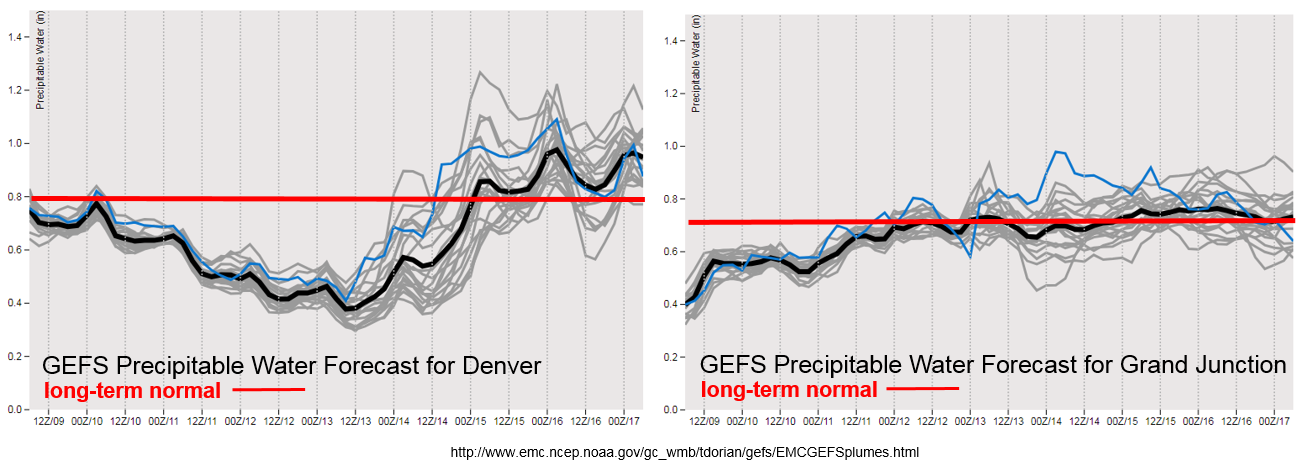
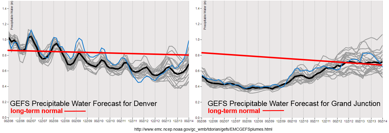
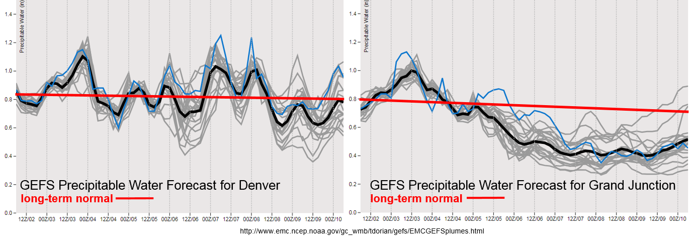
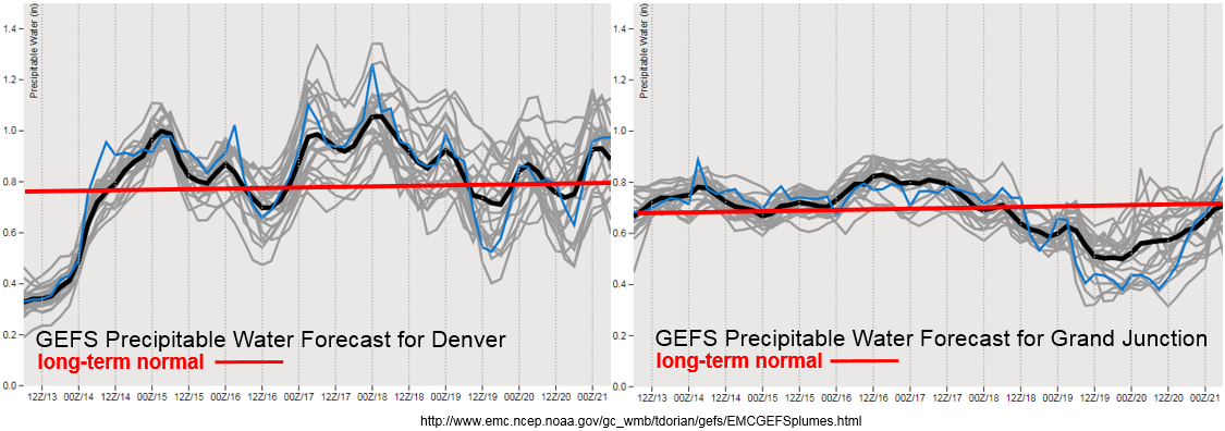
Precipitable Water (PW) starts to return to above average both east and west of the Continental Divide beginning tomorrow. Little spread means there is higher confidence that elevated PW over western Colorado will remain through Friday. This may be an issue for the 416/Burro burn scars especially on Thursday and Friday. Be sure to tune into the daily FTB for more details. Less confidence and more spread in PW values after Thursday for eastern Colorado. Though all members have above average PW. The GEFS is also showing a drop of PW with the frontal passage on Sunday. Overall, looking at a very active week with heavy rainfall possible each day.

Below we describe the identified precipitation event of this FTO in more detail.

Event #1: Tuesday (8/14) – Monday (8/20)

Elevated Threat as a monsoon surge begins for eastern and western Colorado.

As the ridge begins to rebuild itself throughout the next couple of days, PW values will be on the increase. First, the threat will be over the eastern CO with more widespread storms returning to the Front Range and Southeastern Mountains on Tuesday. Recent burn scar flash flooding potential will be monitored and addressed daily in the FTB as small details will change with the forecast day to day. There is a possible severe weather threat on Wednesday over the eastern plains associated with lee troughing and a passing front. Heavy rain, damaging winds and large hail are all possible if the forecast stays on track. After this event, the subtropical ridge begins to slide eastward, which will pull in high low-level moisture to southwest Colorado. While widespread flooding is not forecast, this could be potentially dangerous for the 416/Burro burn scars as storms in the areas would have rain rates in the 0.75-1 inch/hour range. PW begins to drop off this weekend with a potential frontal passage on Sunday bringing cooler temperatures to start next week.

Legend

FTO 08-09-2018: Rainfall Returns to the San Juan and Central Mountains over the Weekend

Issue Date: Thursday, August 9th, 2018
Issue Time: 2:30 PM MDT
Valid Dates: 8/10 – 8/24

Very dry air has worked its way over the western US as the 500mb high spins over the Great Basin. Extreme temperatures associated with this high has place many areas under an Excessive Heat Warning. To start of this FTO period, we will begin with Event #1 from Monday’s FTO. Starting Friday, the ridge will begin to move eastward as the closed low over the Pacific makes its way to the west coast. This will displace the ridge to the east, and a cut-off low, from the previous trough, will place itself over TX/OK. This weekend, the ridge completely breaks down with the passing of the trough to the north, and the cut-off low moves west and north into eastern Colorado where it slowly migrates east through Tuesday. This should keep the chances for rainfall over eastern Colorado minimal due to northeastly flow aloft. Tropical cyclone John will also move north this weekend, but shouldn’t affect the region until early next week by possibly bringing in some extra subtropical moisture. Slight eastward movement of the ridge Friday to Sunday may increase the chances for afternoon rainfall over the San Juan and Central Mountains. Widespread flooding is not anticipated though burn scars may be prone to flash flooding and mud flows.

From Tuesday to Thursday, a weak ridge begins to rebuild over the Pacific Northwest. Slight movements of the center of the 500mb high indicate there will be a chance of showers over eastern Colorado with returned low-level moisture to start Event #2. Tropical Cyclone John is absorbed into the westerlies as well, which has the potential to pull in a little extra moisture. An incoming trough over the Pacific Northwest pushes the ridge far enough east on Friday and Saturday that subtropical moisture is expected to return both east and west over Colorado. Showers will become more widespread, and at this time, there is an Elevated flood threat to start next weekend though there is still low confidence in a forecast this far out.

Precipitable Water (PW) continues to remain below average over western Colorado. A small increase is seen going into this weekend thanks to the slight eastward movement of the ridge. The GEFS continues to hold average PW over the next week, which will allow afternoon showers and thunderstorm to return to the San Juan and Central Mountains. For Event #2, the moisture should be far enough north to return afternoon rainfall chances to the Northern Mountains as well. Eastern Colorado remains quiet heading into this weekend though there is a chance for isolated showers over the mountains with residual moisture under the ridge. By mid-week the subtropical moisture begins to recover with PW returning to above average values. Quite a bit of uncertainty this far out, but the subtropical moisture trend is upwards, so there is the possibility of heavy rainfall returning to the forecast.

Below we describe the two identified precipitation event of this FTO in more detail.

Event #1: Friday (8/10) – Sunday (8/12)

No Apparent Threat as rainfall returns to western Colorado.

Slight shift in the upper-level ridge axis is expected to return some more low-level moisture to the southwest corner of the state. Widespread rainfall is not anticipated, but afternoon showers over the Central and San Juan Mountains are expected to increase. There is still a question as to how much subtropical moisture will return, though a flood threat will likely be unnecessary. Rain rates may exceed the 0.5 inch/hour threshold, which could cause issues with burn scars. Please tune into the daily FTB as those details will evolve day to day. Possible threats include mud flows, debris slides and flash flooding should a storm track directly over a recent burn scar. To the east, northeasterly flow associated with the cut-off low should prevent chances for afternoon showers and thunderstorms. A few storms may be possible along the Continental Divide and far southern Southeast Mountains.


Legend

Event #2: Wednesday (8/15) – Sunday (8/19)

Elevated / No Apparent Threat as subtropical moisture returns with the ridge axis shifting eastward.

Event #2 of this FTO still has a lot of details that are in the works. The GFS continues to shift the upper-level ridge to the east, which would allow subtropical to return to the state both east and west of the Divide. GEFS moisture plumes indicate there is an upward trend in PW throughout the week, which would return the heavy rainfall chances. Tropical Cyclone John may also increase moisture into the area starting on Tuesday as it is absorbed into the next passing system. If this forecast continues to stay on track, the Event looks to return showers and thunderstorms chances to Northern Mountains. Trends in future model runs will be monitored closely throughout this weekend, and new details will be incorporated into Monday’s FTO.

Legend

FTO 08-06-2018: Elevated Flood Threat Continues for Tuesday before the Drying Trend Gets Under Way

Issue Date: Monday, August 6th, 2018
Issue Time: 1:15 PM MDT
Valid Dates: 8/7 – 8/21

The satellite imagery below shows a closed low over the Pacific Ocean, which will control our weather the next week. Currently, the 500mb high is elongated is a bit south over New Mexico and Arizona making the winds aloft westerly. A bit of dry air can be seen over southern Colorado, which will help limit the rain rates along the border this afternoon. Throughout this week, the low will continue to progress slightly eastward and dig south. This will re-center the 500mb high to the northwest and progressively make the winds aloft have more of a northerly component. As the winds begin to become more northerly, this will pull in a dry air mass and provide a downtick in rainfall chances as the week continues. Expecting smoke to return with this flow, too. Residual moisture under the ridge from Tuesday to Thursday, along with northerly flow moving afternoon shortwaves through the state, will be enough to spark some afternoon thunderstorms. The main activity should be confined to the eastern high terrains and immediate adjacent plains. Due to increased convergence along the Palmer Ridge, this will be the most likely area for thunderstorms to survive as they move eastward in the afternoons.

By Friday afternoon, the center of the 500mb high is expected to be over the Great Basin and continue to build north through Saturday. The center of the upper high moves far enough north that it is expected to produce an easterly component to the winds aloft, which will keep the subtropical moisture well to the south of Colorado this weekend. The trough ejects eastward this weekend, but it should remain well to the north of Colorado. The trough re-deepens over western Canada at the beginning of next week, which will shift the ridge axis east and allow some subtropical moisture to return to the state (Event #2). The GFS has a cold front moving through the state on Wednesday of next week, which will help moisten the low-levels and promote upslope flow behind it. At this time, the details of the event will change quite a bit, so there is No Apparent Threat.

The GEFS PW plumes show above average PW to continue into Tuesday for eastern Colorado. Thus, the Elevated Flood Threat. The daily threat over the recent burn scars will be addressed in the daily FTB. After Tuesday, moisture drops off quite a bit with the arid, northerly flow aloft. This will reduce the flood threat; although, afternoon showers and thunderstorms are still likely Wednesday and Thursday with the upslope flow regime. Towards the beginning of next week, the ridge axis shifts slight west and may return the subtropical moisture to the state. There is quite a bit of spread as to how much moisture returns, so we will continue to watch trends from future model runs. Below we describe the two identified precipitation event of this FTO in more detail.

Event #1: Tuesday (8/7) – Thursday (8/9)

Elevated Threat / No Apparent Threat as high PW remains under the building ridge on Tuesday returning the heavy rainfall threat to eastern Colorado.

The upper-level high will begin to rebuild itself over the Pacific Northwest, but low-level moisture should remain high enough to return the threat of heavy rainfall to eastern Colorado on Tuesday. The threat will most likely be over the southern Front Range and Southeast Mountains and extend into the immediate adjacent plains – especially the Palmer Ridge area. At this time, activity looks to increase over the Southeast Mountains, so burn scars may need to be monitored closely tomorrow. Please check back to the FTB tomorrow morning for more specifics. After Tuesday, the drying out begins as arid air will be ushered into the state with more northerly flow. This should limit the heavy rainfall chances, though afternoon showers and thunderstorms will still kick off over the higher terrains in the afternoons on Wednesday and Thursday. If timed correctly with passing shortwaves, some stronger thunderstorms may be possible. This is especially true if they are able to survive and make it into the deeper moisture over the eastern plains. As of right now, the main threat will be gusty winds due to the dry upper-levels in the atmosphere.


Legend

Event #2: Tuesday (8/14) – Thursday (8/16)

No Apparent Threat as subtropical moisture returns with the passage of a cold front mid-week.

No Apparent Threat for Event #2 of this FTO as there is very little confidence in this solution so far. The GFS is currently shifting the upper-level ridge to the east, which would allow subtropical to return to the state. It also shows a cold front passing through the state by mid-week, which will help prime the lower-levels with moisture and promote upslope flow behind it on Wednesday/Thursday for eastern Colorado. If this forecast continues to stay on track, the Event looks to return the flood threat to the western mountains as well. Trends with future model runs will be monitored closely throughout this week, and details are expected to change throughout the next couple of FTOs.

Legend

FTO 08-02-2018: Heavy Rainfall on Friday Poses Flooding Threat for Recent Burn Scars

Issue Date: Thursday, August 2nd, 2018
Issue Time: 2:00 PM MDT
Valid Dates: 8/3 – 8/17

To start this FTO, we’re going to take a minute to look back on the precipitation that fell during July. Below is the departure from normal precipitation from 7/1 – 7/31 (top), which shows above average precipitation for most of eastern Colorado. The exception is over the Raton Ridge, which normally receives between 2-3 inches of rainfall during the monsoon. The majority of western Colorado had below normal precipitation with the Northwest Slope, Northern Mountains, Central Mountains and Grand Valley receiving the least precipitation. The bottom image shows the departure from normal precipitation from 5/1 to 7/31. Excluding the Northeast Plains and northern Front Range, the majority of the state is still in a deficient when it comes to rainfall. This has helped lead to a very active fire season with 13 fires currently burning across the state. Some relief is expected tomorrow, but it will take an unlikely shift of the large-scale atmospheric circulation pattern to catch up to climatology.

Below is the visible satellite imagery, which identifies two events for this next FTO period. Event #1 will begin tomorrow as an upper trough, marked with the orange “X”, will slide to the east and help nudge the axis of the ridge eastward. It will then begin to break down the upper-level ridge and produce more of a zonal pattern aloft with a shortwave embedded in the flow. This shortwave will help provide extra lift for thunderstorm development tomorrow afternoon and evening over the eastern plains and southern mountains. At the surface, a lee trough will set up over eastern Colorado, which should pull in plentiful moisture over the eastern half of the state with southeast flow. Convergence associated with the lee trough will help produce a line of severe thunderstorms over the eastern plains. CAPE and shear will be moderate, but with PW values over 1 inch, storms will be capable of producing heavy rainfall with some gusty winds and hail (1.25 inch).

The trough marked in the picture below begins digging south over the west coast on Saturday and Sunday. Southwest/westerly flow aloft will continue to keep the subtropical moisture to the south over western Colorado. High pressure will likely begin building over the state, so paired with the entrainment of dry air, storm chances decrease Saturday into Sunday. Event #2 begins on Monday after the passage of a cold front on Sunday evening helps return low-level moisture to the atmosphere over eastern Colorado. After Tuesday, the ridge begins to build over the Pacific Northwest and more northerly flow will begin to dry out the atmosphere. The low will continue to spin off the coast of CA through Thursday when it begins to lift to the northeast. Confidence is a bit low this far out, but this would return the heavy rainfall threat at the end of next week.

The GEFS PW plumes show above average PW for Friday both east and west of the Continental Divide. In fact, it is close to or above 1 inch, so this will return the heavy rainfall threat. Burn scars will need to be monitored closely as rain rates from storms that track over the scars will likely be high enough to produce flash flooding, mud flows and debris slides. The more settle details will be addressed in tomorrow’s FTB. After Saturday, dry westerly and southwesterly flow drop PW values over western Colorado. The threat of heavy rainfall for eastern Colorado also decreases, though the southern Southeast Mountains might have enough residual moisture on Saturday for another round of heavy rainfall. On Monday and Tuesday of next week, high PW values return to eastern Colorado for another Elevated flood threat. There seems to be a break in thunderstorm activity after Tuesday.

Below we describe the two identified precipitation event of this FTO in more detail.

Event #1: Friday (8/3) – Saturday (8/4)

Elevated Threat / No Apparent Threat as the ridge moves east and breaks down with the passage of an upper-level trough.

The upper-level high will begin to shift slightly to the east before it breaks down as a trough moves north of Colorado. This should allow subtropical moisture to return to both eastern and western Colorado. PW values greater than 1 inch will produce heavy rainfall, and storms tracking near burn scars should be monitored closely. More severe storms and higher rain rates will be present over the eastern plains. Moderate shear should decrease the threat for large hail and severe thunderstorms, but storms will still be capable of producing hail, strong winds and heavy rainfall. Saturday, coverage and intensity of storms should decrease, but the flood threat may hold on over the far Southeast Mountains. This is especially true if storms track over the same areas as tomorrow where soils will be a bit more saturated and produce higher runoff. The details of this event will be highlighted in the upcoming FTBs.


Legend

Event #2: Monday (8/6) – Wednesday (8/8)

Elevated Threat / No Apparent Threat as southeasterly surface flow pulls in high moisture over the eastern portion of the state.

Less confidence in the forecast due to the GFS solutions varying quite a bit over the last couple of days. Currently, the runs are digging a trough south over the Pacific Ocean. This would place the upper-level ridge west of Colorado, which would put Colorado under more northwesterly flow aloft. A cold front when then be able to pass through eastern Colorado on Sunday evening, which should help prime the lower-levels for heavy rainfall on Monday. Southeasterly surface flow will pull in high moisture over eastern Colorado from the Gulf of Mexico on Monday and Tuesday. Thus, the flood threat would return for the showers and thunderstorms that form under the diurnal flow. Similar to this week, embedded shortwaves will increase thunderstorm coverage on Monday and Tuesday. After Tuesday, more of a northerly component to the upper-level flow would pull in dry air and rising heights would bring a break in afternoon shower and thunderstorm activity.


Legend