Issue Date: Monday, August 6th, 2018
Issue Time: 1:15 PM MDT
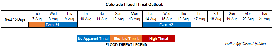
Valid Dates: 8/7 – 8/21
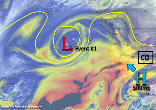
The satellite imagery below shows a closed low over the Pacific Ocean, which will control our weather the next week. Currently, the 500mb high is elongated is a bit south over New Mexico and Arizona making the winds aloft westerly. A bit of dry air can be seen over southern Colorado, which will help limit the rain rates along the border this afternoon. Throughout this week, the low will continue to progress slightly eastward and dig south. This will re-center the 500mb high to the northwest and progressively make the winds aloft have more of a northerly component. As the winds begin to become more northerly, this will pull in a dry air mass and provide a downtick in rainfall chances as the week continues. Expecting smoke to return with this flow, too. Residual moisture under the ridge from Tuesday to Thursday, along with northerly flow moving afternoon shortwaves through the state, will be enough to spark some afternoon thunderstorms. The main activity should be confined to the eastern high terrains and immediate adjacent plains. Due to increased convergence along the Palmer Ridge, this will be the most likely area for thunderstorms to survive as they move eastward in the afternoons.
By Friday afternoon, the center of the 500mb high is expected to be over the Great Basin and continue to build north through Saturday. The center of the upper high moves far enough north that it is expected to produce an easterly component to the winds aloft, which will keep the subtropical moisture well to the south of Colorado this weekend. The trough ejects eastward this weekend, but it should remain well to the north of Colorado. The trough re-deepens over western Canada at the beginning of next week, which will shift the ridge axis east and allow some subtropical moisture to return to the state (Event #2). The GFS has a cold front moving through the state on Wednesday of next week, which will help moisten the low-levels and promote upslope flow behind it. At this time, the details of the event will change quite a bit, so there is No Apparent Threat.
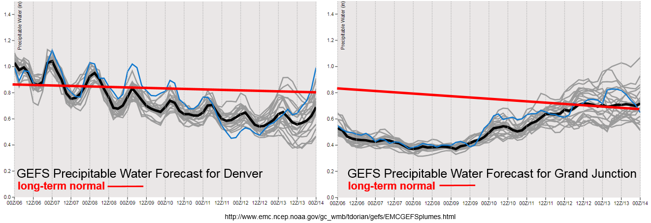
The GEFS PW plumes show above average PW to continue into Tuesday for eastern Colorado. Thus, the Elevated Flood Threat. The daily threat over the recent burn scars will be addressed in the daily FTB. After Tuesday, moisture drops off quite a bit with the arid, northerly flow aloft. This will reduce the flood threat; although, afternoon showers and thunderstorms are still likely Wednesday and Thursday with the upslope flow regime. Towards the beginning of next week, the ridge axis shifts slight west and may return the subtropical moisture to the state. There is quite a bit of spread as to how much moisture returns, so we will continue to watch trends from future model runs. Below we describe the two identified precipitation event of this FTO in more detail.
Event #1: Tuesday (8/7) – Thursday (8/9)
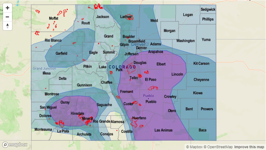
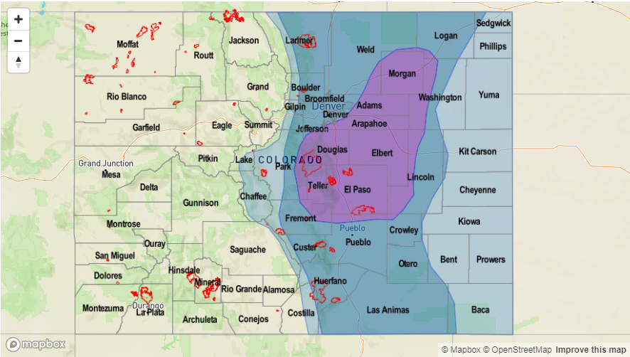
Elevated Threat / No Apparent Threat as high PW remains under the building ridge on Tuesday returning the heavy rainfall threat to eastern Colorado.
The upper-level high will begin to rebuild itself over the Pacific Northwest, but low-level moisture should remain high enough to return the threat of heavy rainfall to eastern Colorado on Tuesday. The threat will most likely be over the southern Front Range and Southeast Mountains and extend into the immediate adjacent plains – especially the Palmer Ridge area. At this time, activity looks to increase over the Southeast Mountains, so burn scars may need to be monitored closely tomorrow. Please check back to the FTB tomorrow morning for more specifics. After Tuesday, the drying out begins as arid air will be ushered into the state with more northerly flow. This should limit the heavy rainfall chances, though afternoon showers and thunderstorms will still kick off over the higher terrains in the afternoons on Wednesday and Thursday. If timed correctly with passing shortwaves, some stronger thunderstorms may be possible. This is especially true if they are able to survive and make it into the deeper moisture over the eastern plains. As of right now, the main threat will be gusty winds due to the dry upper-levels in the atmosphere.

Event #2: Tuesday (8/14) – Thursday (8/16)
No Apparent Threat as subtropical moisture returns with the passage of a cold front mid-week.
No Apparent Threat for Event #2 of this FTO as there is very little confidence in this solution so far. The GFS is currently shifting the upper-level ridge to the east, which would allow subtropical to return to the state. It also shows a cold front passing through the state by mid-week, which will help prime the lower-levels with moisture and promote upslope flow behind it on Wednesday/Thursday for eastern Colorado. If this forecast continues to stay on track, the Event looks to return the flood threat to the western mountains as well. Trends with future model runs will be monitored closely throughout this week, and details are expected to change throughout the next couple of FTOs.