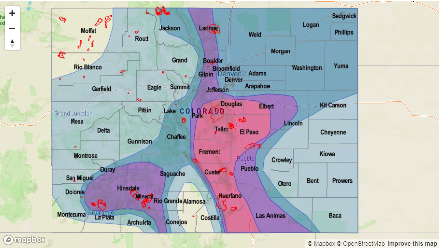
Issue Date: Monday, August 13th, 2018
Issue Time: 1:25 PM MDT
Valid Dates: 8/14 – 8/28
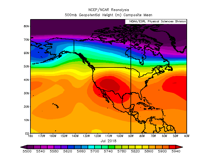
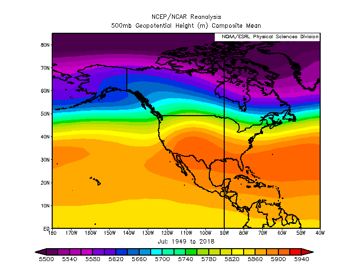
It is mid-August already, which means climatologically we’ve started the descent from the peak of the North American Monsoon (NAM). At the beginning of the season (May), Climate Prediction Center predicted above average precipitation for June, July and August over western Colorado (40-50% probability). Over eastern Colorado, there was equal chance for above/below average precipitation. Unfortunately, the majority of western Colorado continues to be at 10-50% of normal precipitation. To further look into the overall pattern in July (the NAM), we took at a quick look at the NCEP/NCAR reanalysis data. Below is the 500mb geopotential heights for July 2018 (top) and July 1949-2018 or climatology (bottom). It shows that throughout July there was an anomalously strong high pressure center over the southwest US with the axis of the subtropical ridge extending further west than normal. This is similar to what we saw in observations for the Flood Threat Bulletin. For the most part, there were only slight movements with the center of the high to the east and west, which allowed for minimal subtropical moisture return or “monsoon surges” over western Colorado. There is still a chance for a couple more surges before the subtropical ridge shifts back south, but the 2018 monsoon season has been quiet when compared to season’s past.
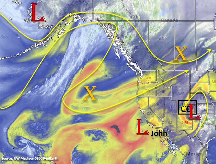
There is only one identified event for this next FTO, which begins tomorrow and brings an Elevated Flood Threat to the state the rest of this week. The upper-level low over southeastern Colorado will begin to move to the east through tomorrow, and in its place, the subtropical ridge will begin to build again over the west. This should allow Gulf of Mexico low-level moisture to start to fill in over eastern Colorado. Thus, there will be an increase of storms over the eastern mountains beginning tomorrow. Flow aloft will become northwesterly again, which will promote an active weather pattern by allowing fronts to pass through the state. On Wednesday, the first boundary passes through the northeast corner of the state and brings a chance for some larger thunderstorms over the eastern plains. High instability and 40 knots of shear associated with a lee trough will promote possibly severe thunderstorms, which would be capable of producing strong winds, large hail and heavy rainfall.
By Thursday, the subtropical ridge will have re-established itself over the PNW with the center of the high pressure over the southwest US and 4-corner region. Flow aloft will become more northerly as well. From Thursday to Friday, the ridge axis will shift eastward and begin to pull in subtropical moisture to the southwest corner of the state. This would make the recent burn scars over the San Juan Mountains prone to flash flooding. The monsoon surge will continue its hold over eastern Colorado during this time with shortwaves possibly moving through each afternoon. By Saturday, the ridge begins to break down again and upper-level flow becomes more zonal. This would likely lower 700mb relative humidity and the threat for heavy rainfall.
Recent GFS runs have a cold front moving through the state late on Sunday, which could return an Elevated flood threat for this weekend. This would also start off next week a bit cooler if the upper trough materializes. Confidence in this solution is low at this time, so please check back to Thursday’s FTO. Further out, the GFS is starting to push some fall-like fronts through the state by the end of this FTO period. Again, confidence is very low in this solution, but it is a reminder that summer is coming to close.
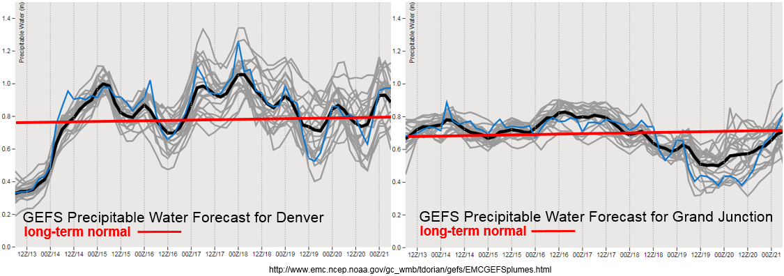
Precipitable Water (PW) starts to return to above average both east and west of the Continental Divide beginning tomorrow. Little spread means there is higher confidence that elevated PW over western Colorado will remain through Friday. This may be an issue for the 416/Burro burn scars especially on Thursday and Friday. Be sure to tune into the daily FTB for more details. Less confidence and more spread in PW values after Thursday for eastern Colorado. Though all members have above average PW. The GEFS is also showing a drop of PW with the frontal passage on Sunday. Overall, looking at a very active week with heavy rainfall possible each day.
Below we describe the identified precipitation event of this FTO in more detail.
Event #1: Tuesday (8/14) – Monday (8/20)
Elevated Threat as a monsoon surge begins for eastern and western Colorado.
As the ridge begins to rebuild itself throughout the next couple of days, PW values will be on the increase. First, the threat will be over the eastern CO with more widespread storms returning to the Front Range and Southeastern Mountains on Tuesday. Recent burn scar flash flooding potential will be monitored and addressed daily in the FTB as small details will change with the forecast day to day. There is a possible severe weather threat on Wednesday over the eastern plains associated with lee troughing and a passing front. Heavy rain, damaging winds and large hail are all possible if the forecast stays on track. After this event, the subtropical ridge begins to slide eastward, which will pull in high low-level moisture to southwest Colorado. While widespread flooding is not forecast, this could be potentially dangerous for the 416/Burro burn scars as storms in the areas would have rain rates in the 0.75-1 inch/hour range. PW begins to drop off this weekend with a potential frontal passage on Sunday bringing cooler temperatures to start next week.

