Issue Date: Thursday, August 2nd, 2018
Issue Time: 2:00 PM MDT
Valid Dates: 8/3 – 8/17

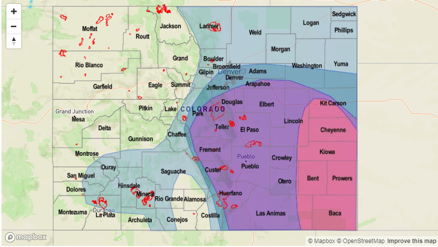
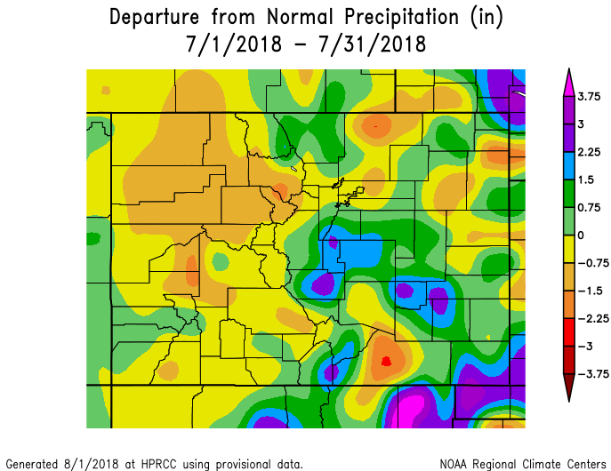
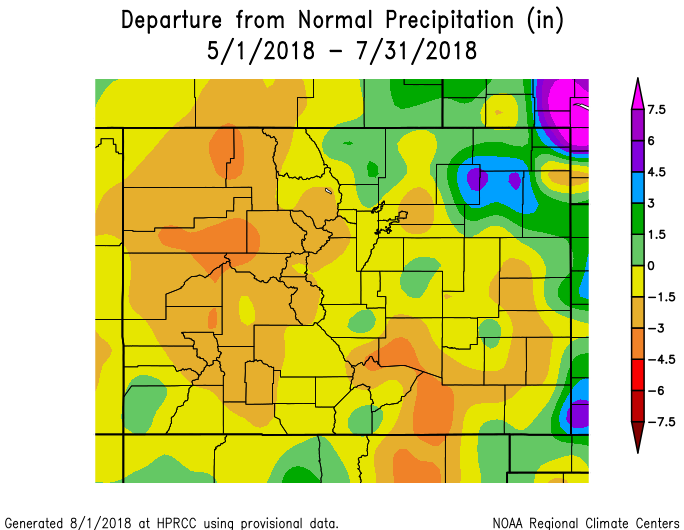
To start this FTO, we’re going to take a minute to look back on the precipitation that fell during July. Below is the departure from normal precipitation from 7/1 – 7/31 (top), which shows above average precipitation for most of eastern Colorado. The exception is over the Raton Ridge, which normally receives between 2-3 inches of rainfall during the monsoon. The majority of western Colorado had below normal precipitation with the Northwest Slope, Northern Mountains, Central Mountains and Grand Valley receiving the least precipitation. The bottom image shows the departure from normal precipitation from 5/1 to 7/31. Excluding the Northeast Plains and northern Front Range, the majority of the state is still in a deficient when it comes to rainfall. This has helped lead to a very active fire season with 13 fires currently burning across the state. Some relief is expected tomorrow, but it will take an unlikely shift of the large-scale atmospheric circulation pattern to catch up to climatology.
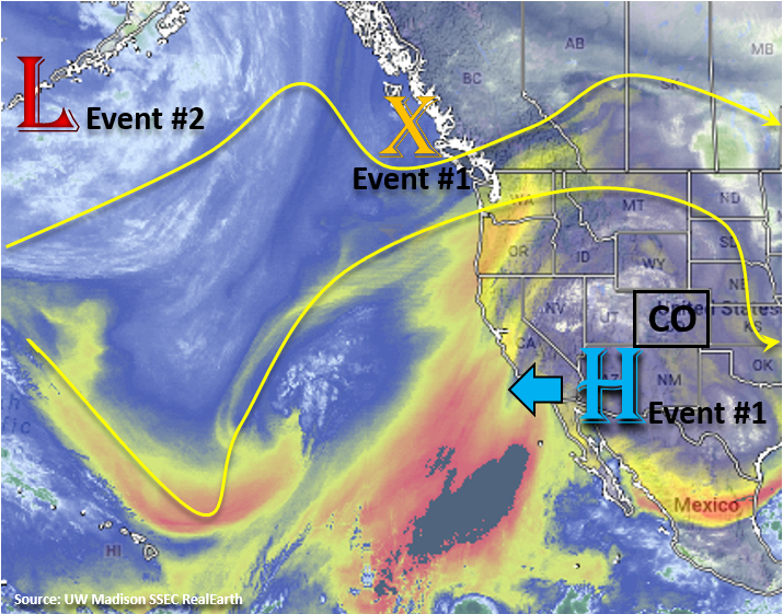
Below is the visible satellite imagery, which identifies two events for this next FTO period. Event #1 will begin tomorrow as an upper trough, marked with the orange “X”, will slide to the east and help nudge the axis of the ridge eastward. It will then begin to break down the upper-level ridge and produce more of a zonal pattern aloft with a shortwave embedded in the flow. This shortwave will help provide extra lift for thunderstorm development tomorrow afternoon and evening over the eastern plains and southern mountains. At the surface, a lee trough will set up over eastern Colorado, which should pull in plentiful moisture over the eastern half of the state with southeast flow. Convergence associated with the lee trough will help produce a line of severe thunderstorms over the eastern plains. CAPE and shear will be moderate, but with PW values over 1 inch, storms will be capable of producing heavy rainfall with some gusty winds and hail (1.25 inch).
The trough marked in the picture below begins digging south over the west coast on Saturday and Sunday. Southwest/westerly flow aloft will continue to keep the subtropical moisture to the south over western Colorado. High pressure will likely begin building over the state, so paired with the entrainment of dry air, storm chances decrease Saturday into Sunday. Event #2 begins on Monday after the passage of a cold front on Sunday evening helps return low-level moisture to the atmosphere over eastern Colorado. After Tuesday, the ridge begins to build over the Pacific Northwest and more northerly flow will begin to dry out the atmosphere. The low will continue to spin off the coast of CA through Thursday when it begins to lift to the northeast. Confidence is a bit low this far out, but this would return the heavy rainfall threat at the end of next week.
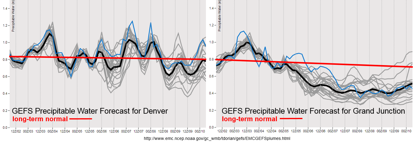
The GEFS PW plumes show above average PW for Friday both east and west of the Continental Divide. In fact, it is close to or above 1 inch, so this will return the heavy rainfall threat. Burn scars will need to be monitored closely as rain rates from storms that track over the scars will likely be high enough to produce flash flooding, mud flows and debris slides. The more settle details will be addressed in tomorrow’s FTB. After Saturday, dry westerly and southwesterly flow drop PW values over western Colorado. The threat of heavy rainfall for eastern Colorado also decreases, though the southern Southeast Mountains might have enough residual moisture on Saturday for another round of heavy rainfall. On Monday and Tuesday of next week, high PW values return to eastern Colorado for another Elevated flood threat. There seems to be a break in thunderstorm activity after Tuesday.
Below we describe the two identified precipitation event of this FTO in more detail.
Event #1: Friday (8/3) – Saturday (8/4)
Elevated Threat / No Apparent Threat as the ridge moves east and breaks down with the passage of an upper-level trough.
The upper-level high will begin to shift slightly to the east before it breaks down as a trough moves north of Colorado. This should allow subtropical moisture to return to both eastern and western Colorado. PW values greater than 1 inch will produce heavy rainfall, and storms tracking near burn scars should be monitored closely. More severe storms and higher rain rates will be present over the eastern plains. Moderate shear should decrease the threat for large hail and severe thunderstorms, but storms will still be capable of producing hail, strong winds and heavy rainfall. Saturday, coverage and intensity of storms should decrease, but the flood threat may hold on over the far Southeast Mountains. This is especially true if storms track over the same areas as tomorrow where soils will be a bit more saturated and produce higher runoff. The details of this event will be highlighted in the upcoming FTBs.

Event #2: Monday (8/6) – Wednesday (8/8)
Elevated Threat / No Apparent Threat as southeasterly surface flow pulls in high moisture over the eastern portion of the state.
Less confidence in the forecast due to the GFS solutions varying quite a bit over the last couple of days. Currently, the runs are digging a trough south over the Pacific Ocean. This would place the upper-level ridge west of Colorado, which would put Colorado under more northwesterly flow aloft. A cold front when then be able to pass through eastern Colorado on Sunday evening, which should help prime the lower-levels for heavy rainfall on Monday. Southeasterly surface flow will pull in high moisture over eastern Colorado from the Gulf of Mexico on Monday and Tuesday. Thus, the flood threat would return for the showers and thunderstorms that form under the diurnal flow. Similar to this week, embedded shortwaves will increase thunderstorm coverage on Monday and Tuesday. After Tuesday, more of a northerly component to the upper-level flow would pull in dry air and rising heights would bring a break in afternoon shower and thunderstorm activity.