FTO 08-27-2018: Cold Front Brings Fall-like Temperatures to Eastern Colorado on Tuesday

Issue Date: Monday, August 27th, 2018
Issue Time: 12:25 PM MDT
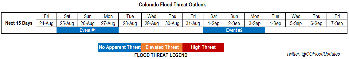
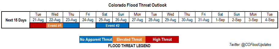
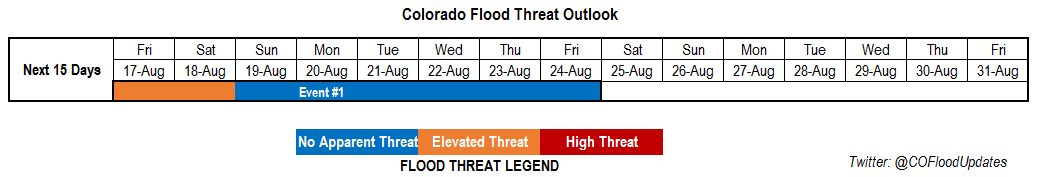
Valid Dates: 8/28 – 9/11

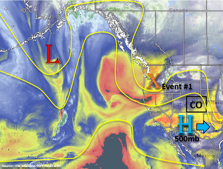
This is expected to be a fairly slow FTO period with dry air being entrained into Colorado due to westerly flow aloft and limiting the heavy rainfall potential. The subtropical high continues to sit over the Pacific with several troughs passing on its north side. These troughs are expected to stay north of the state for this FTO with the exception of the current trough to our north. Today into tomorrow the axis of the trough will affect the northern portion of the state. Today, the main threats will be gusty winds and low relative humidity combining to create critical fire weather. Tonight, the passage of a cold front will increase relative humidity values and reduce high temperatures over the eastern plains for Tuesday. This should in turn reduce the critical fire weather for tomorrow.

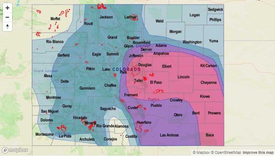
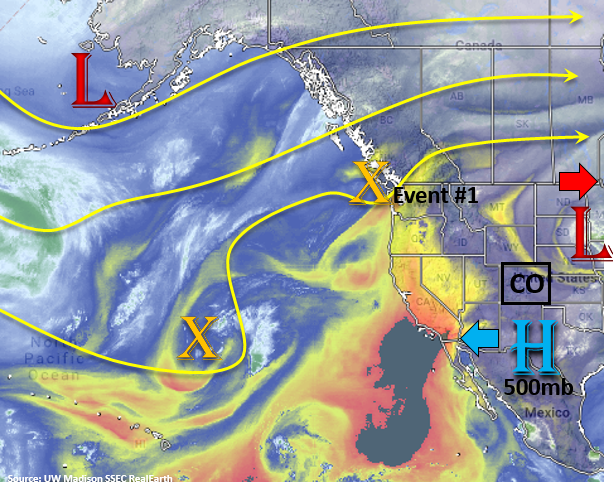
For Tuesday, an upper-level jet oriented from the southwest to northeast will set up over southern Wyoming. With the air mass being near saturation after the passing cold front and northern Colorado being located in the right entrance region of the jet streak, shower and thunderstorm development is expected over the Front Range, Urban Corridor and portions of the Northeast Plains. At the same time, post-frontal upslope flow is expected to increase showers along the Palmer Divide and Southeast Mountains. Storm motion to the southeast will be fairly swift, so widespread flooding is not expected with this band of showers and thunderstorms. Please tune into the FTB tomorrow as increased moisture and slower steering winds may lead to storms producing some localized flooding threats further south.

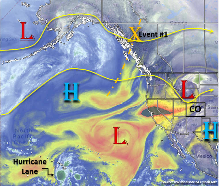
After Tuesday, westerly flow aloft will return to the state, which will scour out moisture over eastern Colorado and promote downsloping winds. Moisture will also be limited over western Colorado, so the only threat will be a few light showers along and near the Continental Divide each afternoon. The zonal flow aloft will also begin to return warmer temperatures through the end of this week.  Early Saturday morning, a weak cold front may drop across the eastern plains. With a weak trough progged to move through the state in the afternoon and upslope flow increasing behind the front, showers and thunderstorms may return to the forecast. While moisture will be limited, this may help trigger a few isolated thunderstorms capable of producing gusty winds. Flow aloft turns more southwesterly on Sunday as a trough moves onto the west coast (Event #2). This flow aloft is expected to increase subtropical moisture across the state, which will cause an uptick in thunderstorm and shower coverage over the holiday weekend. By Monday, flow will become westerly again, so afternoon storm chances will decrease Monday into Tuesday.

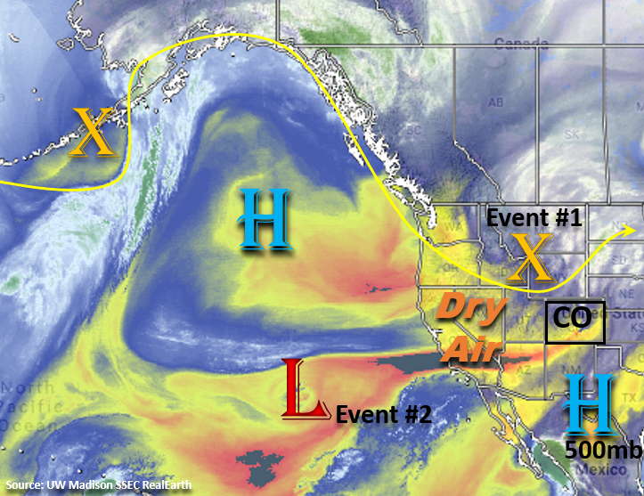
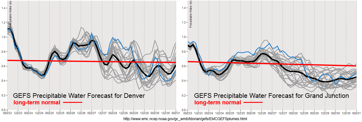
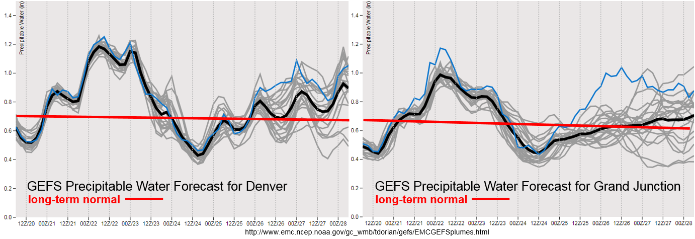
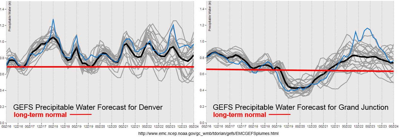
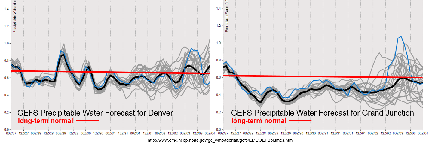
As forecast, exceptionally dry air has worked its way into Colorado with the westerly flow aloft. Precipitable Water (PW) values are expected to drop off and remain below average for western Colorado through the end of the week. Subtropical moisture return for this weekend is still questionable as the GEFS PW plumes show a lot of variation between the members. There is also quite a bit of spread at the end of the week over eastern Colorado though there seems to be a slight upward trend. So, at this time there is No Apparent Threat for Event #2. PW over eastern Colorado does look to increase after the cold front passage later tonight. This may cause some localized heavy rainfall tomorrow though, at this time, widespread flooding is not expected. Scroll down below to find out more about the two identified precipitation event of this FTO.

Event #1: Tuesday (8/28)

No Apparent Threat as post-frontal upslope flow and upper dynamics combine over eastern Colorado for afternoon and evening rainfall.

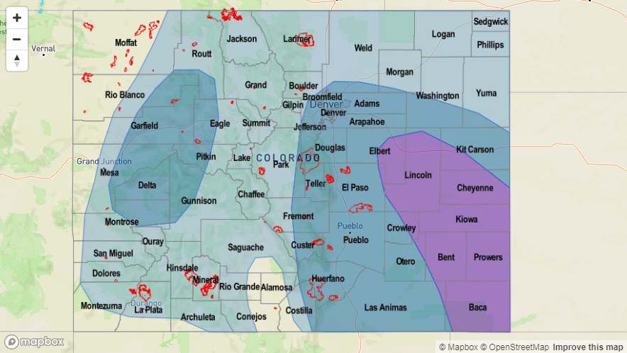
A strong cold front is forecast to drop over eastern Colorado overnight. This will help return low-level moisture for tomorrow afternoon’s upslope flow regime, so expect showers and thunderstorms to return to the forecast for the eastern mountains and Palmer Ridge. At the same time, a southwest to northeast oriented jet will slowly drop south into northern Colorado. With this area under the right entrance region, upper divergence will promote upward motion. So a band of showers will likely develop in the afternoon and evening oriented in the same manner. Fairly quick motion to the southeast should limit the flooding potential, but some localized flooding may be possible depending on the instability that can build and how much low-level moisture returns. Over the Southeast Mountains and adjacent plains, slower storm motion may be an issue for recent burn scars and urban areas. At this time there is No Apparent Threat, but be sure to tune into the FTB tomorrow as small changes in the details may affect the flood forecast. Over western Colorado, low-level moisture is expected to decrease with the entrainment of drier air. There still may be a chance for some light showers over the Northern Mountains nears the Continental Divide, but flooding is not expected.


Legend

Event #2: Saturday (9/1) – Sunday (9/2)

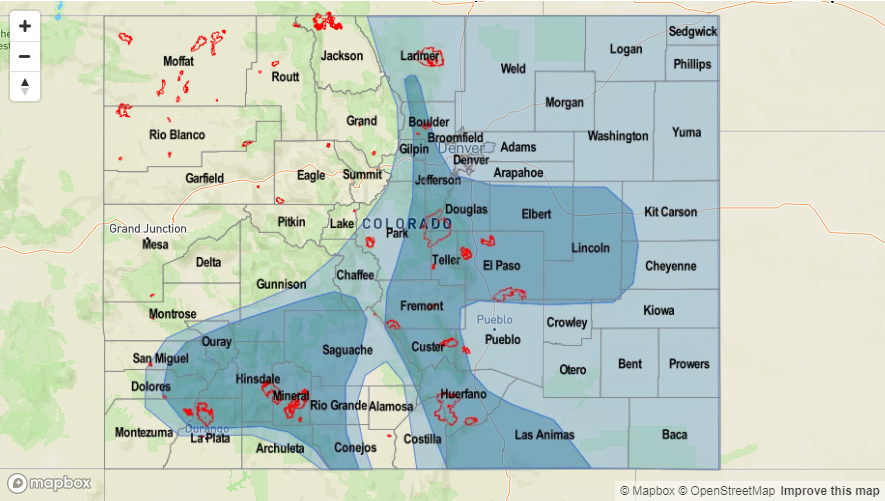
No Apparent Threat as southwesterly flow returns with another trough moving into California.

On Saturday morning, models show a weak cold front passing over eastern Colorado. Upslope flow and a shortwave moving through the state on Saturday afternoon may help trigger some more widespread storm development. However, low-level moisture is still expected to be somewhat limited, so the main threat will be gusty winds and dangerous lightning. By Sunday flow aloft turns more southwesterly, which may allow a bit more subtropical moisture to return to the state. Unsure of how much moisture will return, but an uptick in afternoon storm activity statewide is anticipated. At this time there is No Apparent Threat though that may change by the next FTO. The higher low-level moisture values are short-lived as downsloping winds return on Monday and Tuesday. This will push the higher dew points east and cause a downturn in afternoon storm activity.


Legend

FTO 08-23-2018: Active Weather Pattern Continues with a Break from Rainfall Expected Next Week

Issue Date: Thursday, August 23rd, 2018
Issue Time: 12:15 PM MDT
Valid Dates: 8/24 – 9/7

This next FTO period is expected to have on and off rainfall activity with an almost repetitive pattern of troughs dropping into the Pacific Northwest and then lifting to the northeast. There is very little movement in the subtropical high over the Pacific, which is leading to this recurring cycle. The troughs movement will produce east and west change in the ridge axis, which will bring on and off subtropical moisture into the state. Currently, the trough that brought our last monsoon moisture surge is passing over the northern border of Colorado. This is pulling in dry air behind it and promoting downsloping flow across the state. Subsidence and dry air entrainment will continue on Friday as the next trough starts to dig in over the northwest (Event #1).

Starting Saturday, flow aloft will turn more to the southwest and the ridge axis will shift eastward. The center of the 500mb high shifts into eastern Texas, which allows subtropical moisture to return to eastern Colorado and the southwest corner of the state. This surge is not expected to be as strong as the last, but rain rates could still pose a threat to burn scars over this weekend and an uptick in shower activity. The pattern holds on Sunday, but the high pressure becomes a bit more elongated and shifts into the southeast US through Monday. Low-level moisture is expected to decrease with this movement, with the higher subtropical moisture shifting south and east of Colorado. Tuesday the trough begins its migration eastward, which may brush the northern border of Colorado and drop a weak cold front through the Northeast Plains. Behind the trough, more zonal flow aloft will promote drying and downslope flow through the rest of the week. Weak and isolated showers will still be possible over the higher terrains during the afternoon and evening hours.

Event #2 begins at the end of next week as another trough rounds the subtropical high over the Pacific and deepens over the west coast. Southwesterly flow is forecast to return to the state, but there is a lot of uncertainty as to where the center of the 500mb high will set up at this time and the strength of the trough. Both these details will determine the magnitude and location of the subtropical moisture return. Nonetheless, it looks like a potentially stormy pattern, or at least uptick in storm coverage, for the holiday weekend.

Some exceptionally dry air will work its way into Colorado with the westerly flow aloft over the next couple of days. PW values are expected to drop from the 90th percentile to the 10th percentile in about a 36 hour span. These very dry conditions are expected to create some critical fire weather, so please use caution with any open flames. The GEFS begins an upward trend in moisture towards the end of this week statewide with the next trough arrival. Moisture return further north over western Colorado is not expected to be as strong as this last surge, so storms that do form will likely produce gusty winds. Zonal flow at the beginning of next week is expected to decrease PW values once again, which should cause a downtick in afternoon thunderstorm activity. Below we describe the two identified precipitation event of this FTO in more detail.

Event #1: Saturday (8/25) – Monday (8/27)

No Apparent Threat as a trough digs south over the west coast and southwest flow aloft over CO pulls in a bit of subtropical moisture into the state.

Another, weaker monsoon moisture surge is likely this weekend. This should mostly affect eastern Colorado and the southwest corner of the state. Thunderstorms are expected over the northern portion of western Colorado, but will likely produce more gusty winds than rainfall. Shortwaves are forecast to move through each day, and if timed correctly, will help provide an uptick in thunderstorm coverage. Over the higher terrains, rain rates have the potential to cause problems for recent burn scars without much flooding expected elsewhere. Some severe thunderstorms are possible on Saturday over the eastern plains, but with decent storm motion and moderate dew points, flooding is not expected at this time. Sunday into Monday there will be a downtick in storm activity from west to east as the trough passes north of Colorado and downsloping flow begins.

Legend

Event #2: Saturday (9/1) – Monday (9/3)

No Apparent Threat as southwesterly flow returns with another troughing pattern over the west coast.

For Event #2 there is still a quite a bit that can change. With an almost repetitive pattern in place, another trough is expected to set up over the east coast at the end of next week. This should push the ridge axis eastward and return southwesterly flow aloft. At this time, it is unknown how much low-level moisture will be pulled northward into the state, but this pattern is typical for an uptick in storm development. Moisture will likely return to the west first and spread eastward from there. With it being a holiday weekend, it is best to be prepared though details are likely to change in Monday and Thursday’s FTO. Please tune back in then for the latest details and evolution of Event #2.


Legend

FTO 08-20-2018: Monsoon Surge on Tuesday and Wednesday Bring an High Flood Threat into the Forecast

Issue Date: Monday, August 20th, 2018
Issue Time: 1:45 PM MDT
Valid Dates: 8/21 – 9/4

High flood threat along with an Elevated flood threat to start this FTO period as a traditional monsoon pattern sets up and a subtropical moisture plume surges north across the state (Event #1). It has been awhile since we’ve seen this pattern, which will bring some much needed rainfall to northwest corner of the state where a severe drought is in full swing. The upper trough over the Pacific Northwest will slightly push the ridge and center of the 500mb high to the east on Tuesday and allow for an influx of subtropical moisture both east and west of the Continental Divide. The trough will also eject a strong shortwave over the state, which should enhance vertical motion and create more widespread showers and thunderstorms over the higher terrains in the afternoon. High instability and moderate shear will bring a threat for some more severe storms over the far Southeast Plains. Slow steering winds under the ridge will allow storms to produce very heavy rainfall rates in the moisture-rich environment. This will be especially dangerous for recent burn scars over the next couple of days. The high remains over TX through Wednesday evening, which will continue the Elevated flood threat for Wednesday. One reason for the Elevated threat is that heavy rainfall on Tuesday may saturate soils in places and increase runoff on Wednesday. Also, steeper terrains may also have loosened soils, which would mean it would not take much rainfall to trigger additional mud flows and debris slides. However, the Elevated threat for Wednesday is a bit more complicated than it initially seems. Overnight rainfall on Tuesday may make storms more isolated on Wednesday and greatly limit instability over areas. Please tune into the Flood Threat Bulletin on Wednesday morning as the details of the small details for the forecast will become more clear.

By Thursday, the trough moves eastward and brushes the northern border of Colorado. At this time, westerly flow will increase and begin to dry out the air mass, which will cause a downtick in thunderstorm activity. On Friday, westerly flow will increase even more and should dry out the air mass enough to give us a break from rainfall. On Saturday, Event #2 begins as flow aloft turns more southwesterly and pulls high moisture back into the state. The 500mb high builds over eastern TX and southeasterly flow at the surface will return high dew points to eastern Colorado. There is also a chance for subtropical moisture to return over the southwestern corner depending on where the 500mb sets up. Weak flow aloft should return the chance for heavy rainfall, but at this time, there is No Apparent threat. By Monday, the high moves over the southeast US and strong southeasterly flow aloft will pull in a very arid air mass over the state. All in all, the start to next week is expected be cool and dry at this time.

Extremely high PW values working their way north with this next monsoon surge. A strong anomalous surface high will work its way down from the north, which is always a precursor to heavy rainfall over Colorado. PW values over Denver will be about as high as they get for this time of year. The daily max for Denver is about 1.25 inches, and we will be getting very close that record. For Grand Junction we will easily be in the 90th percentile for this time year. With slow steering winds aloft, heavy widespread rainfall is likely tomorrow. The forecast is a little more complicated for Wednesday, but the high moisture sticks around, which will bring an Elevated flood threat. Moisture decreases in the wake of the trough until Saturday and Sunday where the GEFS hints at a return of low-level moisture. Quite a bit of spread for western Colorado, which means some of the members of the ensemble have subtropical moisture returning and others do not. Good consensus that showers and thunderstorms will be on the rise over eastern Colorado, though how much moisture will return is unknown. At this time there is No Apparent threat.

Below we describe the two identified precipitation event of this FTO in more detail.

Event #1: Tuesday (8/21) – Thursday (8/23)

High Threat / Elevated Threat / No Apparent Threat as a typical monsoon pattern sets up and a subtropical moisture plume moves north.

High/Elevated Threat for Tuesday – Wednesday of this week. The 500mb subtropical high sets up over Texas, which will pull ample subtropical moisture north into the state. This means there will be a good chance for some wetting rains over the northwest corner of the state, which very much needs the precipitation. However, rain rates may also be high enough to cause some flooding issues. Slow steering winds aloft and a passing shortwave mean widespread, heavy rainfall is likely tomorrow. Over the Southeast Plains, a couple of severe storms are possible with the main threats being strong winds, severe hail and heavy rainfall. Burn scars will be especially vulnerable to flooding over the next couple of days. Threats over the steeper terrains include mud flows, debris slides and local stream flooding. Over the lower elevations, flooding of low-lying streets, field ponding and arroyo flooding are all possible.  The flood threat for Tuesday will likely be overnight as upper-level jet will continue to promote upward motion in the high moisture environment. This may make the forecast for Wednesday a bit more complicated, but there should be some breaks in cloud cover that allow instability to build for another round of afternoon thunderstorms. The most likely area for thunderstorm development and heavy rainfall on Wednesday will be over the southern high terrains. Please tune into the FTB tomorrow for a more detailed forecast and more precise location of the heavy rainfall.


Legend

Event #2: Saturday (8/18) – Sunday (8/19)

No Apparent Threat as southwesterly flow aloft begins to pull subtropical moisture back into the state.

Event #2 of this FTO still has a lot of details that are in the works, but there will likely be in uptick in thunderstorm activity over eastern Colorado. Flow aloft will turn from westerly to more southwesterly and surface flow over eastern CO will become more southeasterly this weekend. This should begin to pull in higher dew points to eastern Colorado, though how much is still unknown at this time. There is also a chance for subtropical moisture to return to southwest CO. At this time, this would mostly be problematic for the recent burn scars. Nonetheless, expecting increasing showers this weekend after a break from rainfall on Friday. Trends in the subtropical moisture return will be monitored closely with future model runs, and new details will be incorporated into Thursday’s FTO.

Legend

FTO 08-16-2018: Elevated Flood Threat before Cold Front Slides Through on Sunday

Issue Date: Thursday, August 16th, 2018
Issue Time: 1:15 PM MDT
Valid Dates: 8/17 – 8/31

As pointed out in the FTB this morning, the remnants of the last trough are now over the Midwest and the system will continue to push eastward. In its wake, an arid air mass has pushed into northern Colorado. Beginning Friday morning, increased moisture will arrive to this region (east of the Divide) as SE surface winds return with an approaching shortwave. With weak surface winds aloft, there is an Elevated Threat to start this FTO period. Moisture trapped under the ridge over southwest Colorado will again spark another round of afternoon thunderstorms favoring the San Juan and southern Central Mountains on Friday.

On Saturday, the upper-level trough marked in the water vapor imagery below begins to move inland and displace/breakdown the weak ridge. Positive vorticity advection (PVA) on the east side of the trough will provide a large amount of lift for widespread thunderstorms. Early Saturday, showers will begin over the Northwest Slope and increase north to south by early afternoon. By the mid-afternoon hours, the trough will arrive to the eastern mountains where upslope flow and daytime heating are occurring. A line of convergence is expected to produce a strong line of thunderstorms over the adjacent plains by early afternoon with plenty of thunderstorm action over the higher terrains as well. Threats include large hail, damaging winds and heavy rainfall. While moisture over the mountains won’t be quite as deep as over the adjacent plains, rain rates are expected to be high enough to cause flooding concerns near recent burn scars. Steering winds should be quick with the mid-level jet streak, so widespread flooding over the mountains is not a concern at this time. Though these details may change over the next couple of runs. Dew points over the eastern plains could reach 60F, so there are flooding concerns despite swift southeast movement of the storms.

Sunday, activity looks to calm down a bit as the trough drops a cold front over the state. This is expected to draw in some dry air with northerly flow, cap convection and bring much cooler temperatures. While no strong convection is forecast, there is a chance for some stratiform rain associated with the front. To start next week, the ridge begins to build north of Colorado once again. A second trough forms over the Pacific Northwest, but at this time, the models lift the trough north. This should keep northwesterly flow over the state and increase the chances for upper-level disturbances to pass through the state each afternoon through the end of the week. The big question each day will be the availability of low-level moisture. At this time there should be enough residual moisture under the ridge to the west and daily southeasterly flow to the east that mountain convection will be possible each afternoon. There is not enough confidence at this time to forecast anything more than No Apparent Threat.

Quite a jump in Precipitable Water (PW) for Denver starting tomorrow as southeasterly surface flow returns. Not much change for western Colorado. With steering flows aloft being light again tomorrow, burn scars will be monitored closely. On Saturday, PW begins to drop off statewide with the exception of the far eastern plains. Western movement of the 500mb high is expected to decrease rainfall chances over western Colorado until next week when the ridge begins to build and the 500mb high shifts east again. Not much confidence in low-level moisture after Tuesday as the GEFS shows a lot of variability both east and west. This likely has to do with how strong the ridge rebuilds and the location of its axis. All details that are nearly impossible to pinpoint this far out. Nonetheless, there should be enough moisture for daily rounds of thunderstorms with the diurnal flow.

Below we describe the identified precipitation event of this FTO in more detail.

Event #1: Friday (8/17) – Friday (8/24)

Elevated Threat/ No Apparent Threat for severe weather on Saturday and potential heavy rainfall over the eastern plains.

Elevated Threat for Friday as slow steering winds aloft and low-level moisture combine over eastern Colorado. Not much change in PW over the southwest corner of the state, but slow steering winds could cause problems for the 416/Burro burn areas. Saturday looks to have the best potential for flooding as the approach trough brings widespread PVA and strong upper-level winds. While steering flow will increase, large scale lift will promote widespread thunderstorm development. This will be most problematic over the eastern plains where high PW could lead to widespread, heavy rainfall, large hail and damaging winds associated with the line of convection. After Saturday, Sunday should bring a break in heavy rainfall as dry air moves in behind the trough. Some stratiform rain may occur with the passage of the cold front, but this is not expected to cause any flooding issues at this time. Monday to Friday of next week, the ridge begins to build north of Colorado. The strength and location of the ridge is a little hard to determine at this time, but there could be a couple days with a flood threat next week. There should at least be enough moisture for daily rounds of thunderstorms with the diurnal flow. Please check back to Monday’s FTO for more details.


Legend